Texas Spring-2015
Moderator: S2k Moderators
Forum rules

The posts in this forum are NOT official forecast and should not be used as such. They are just the opinion of the poster and may or may not be backed by sound meteorological data. They are NOT endorsed by any professional institution or STORM2K.
-
Texas Snowman

- Storm2k Moderator

- Posts: 6197
- Joined: Fri Jan 25, 2008 11:29 am
- Location: Denison, Texas
Large (maybe 1/2 to 3/4 of a mile wide) tornado on the ground SW of OKC Metro.
Again.
Again.
0 likes
The above post and any post by Texas Snowman is NOT an official forecast and should not be used as such. It is just the opinion of the poster and may or may not be backed by sound meteorological data. It is NOT endorsed by any professional institution including storm2k.org. For official information, please refer to NWS products.
-
Texas Snowman
- Storm2k Moderator
- Posts: 6197
- Joined: Fri Jan 25, 2008 11:29 am
- Location: Denison, Texas
Headed for Tuttle, Mustang and west side of OKC.
0 likes
The above post and any post by Texas Snowman is NOT an official forecast and should not be used as such. It is just the opinion of the poster and may or may not be backed by sound meteorological data. It is NOT endorsed by any professional institution including storm2k.org. For official information, please refer to NWS products.
-
TheProfessor

- Professional-Met

- Posts: 3506
- Age: 29
- Joined: Tue Dec 03, 2013 10:56 am
- Location: Wichita, Kansas
-
Texas Snowman
- Storm2k Moderator
- Posts: 6197
- Joined: Fri Jan 25, 2008 11:29 am
- Location: Denison, Texas
OKC has reached and soon will exceed it's rainfall record for the month of May (14.52 inches...and counting).
0 likes
The above post and any post by Texas Snowman is NOT an official forecast and should not be used as such. It is just the opinion of the poster and may or may not be backed by sound meteorological data. It is NOT endorsed by any professional institution including storm2k.org. For official information, please refer to NWS products.

Re: Texas Spring-2015
TheProfessor wrote:Heavy rain here in San Antonio, i'm not sure where I'm exactly at though. Water is starting to cover up the parking lot at my hotel.
Be careful. San Antonio floods easily and often. We once got got caught in a flood on .Loop 410 under an underpass.
0 likes
-
TheProfessor
- Professional-Met
- Posts: 3506
- Age: 29
- Joined: Tue Dec 03, 2013 10:56 am
- Location: Wichita, Kansas
Re: Texas Spring-2015
Shoshana wrote:TheProfessor wrote:Heavy rain here in San Antonio, i'm not sure where I'm exactly at though. Water is starting to cover up the parking lot at my hotel.
Be careful. San Antonio floods easily and often. We once got got caught in a flood on .Loop 410 under an underpass.
Yeah, the good thing is my family knows the dangers of flooded roads, my dad is from Huston and spent summers in San Antonio. The most dangerous time here is if we are going to be traveling in the dark where it's harder to see roads.
0 likes
An alumnus of The Ohio State University.
Your local National Weather Service office is your best source for weather information.
Your local National Weather Service office is your best source for weather information.

-
TheProfessor
- Professional-Met
- Posts: 3506
- Age: 29
- Joined: Tue Dec 03, 2013 10:56 am
- Location: Wichita, Kansas
-
TheProfessor
- Professional-Met
- Posts: 3506
- Age: 29
- Joined: Tue Dec 03, 2013 10:56 am
- Location: Wichita, Kansas
-
TheProfessor
- Professional-Met
- Posts: 3506
- Age: 29
- Joined: Tue Dec 03, 2013 10:56 am
- Location: Wichita, Kansas
My dad took my sister and I to the hotel were my parents were attending a wedding at because its up hill, we may not make it back to our hotel tonight due to flooding.
0 likes
An alumnus of The Ohio State University.
Your local National Weather Service office is your best source for weather information.
Your local National Weather Service office is your best source for weather information.
-
Texas Snowman
- Storm2k Moderator
- Posts: 6197
- Joined: Fri Jan 25, 2008 11:29 am
- Location: Denison, Texas
Over 3 inches of rain in OKC today, Norman NWS says daily record of 4-inches plus will likely fall.
OKC now sitting at 17.61 inches of rain for May 2015. Just unreal, unreal.
Seeing photos coming out of the Texas Hill Country of massive flooding along the Frio and Blanco Rivers.
And Lake Texoma is now about six-inches from topping the spillway.
Pretty unreal run of wet weather.
OKC now sitting at 17.61 inches of rain for May 2015. Just unreal, unreal.
Seeing photos coming out of the Texas Hill Country of massive flooding along the Frio and Blanco Rivers.
And Lake Texoma is now about six-inches from topping the spillway.
Pretty unreal run of wet weather.
0 likes
The above post and any post by Texas Snowman is NOT an official forecast and should not be used as such. It is just the opinion of the poster and may or may not be backed by sound meteorological data. It is NOT endorsed by any professional institution including storm2k.org. For official information, please refer to NWS products.

Re:
TheProfessor wrote:My dad took my sister and I to the hotel were my parents were attending a wedding at because its up hill, we may not make it back to our hotel tonight due to flooding.
Stay safe and heed the flood warnings. A couple of tornado warnings were also in the SA area.
Meanwhile here in North Texas a train is setting up over Dallas county (central and western side) heading from south to north.
0 likes
The above post and any post by Ntxw is NOT an official forecast and should not be used as such. It is just the opinion of the poster and may or may not be backed by sound meteorological data. It is NOT endorsed by any professional institution including Storm2k. For official information, please refer to NWS products.
Help support Storm2K!
Re: Texas Spring-2015
Tornado Warning in and near Austin. Bow echo, severe thunderstorm warning. Currently can't cut n paste actual warning
0 likes

Re: Texas Spring-2015
TeamPlayersBlue wrote:Ntxw wrote:TeamPlayersBlue wrote:I would really like to see this for Houston. We seriously dont see the sun after 10 am anymore. Ever.
Houston (IAH) to date
Partly/Mostly Cloudy days - 127
Clear days - 15
Days with QPF 0.01 or more - 58
Depression.
Now you know what its like to be in many parts of Canada during the winter - its actually worse here with weeks non-stop of overcast and to get no sun for what seems like the whole season. Depression is the only word for it, and it sucks more than one might think.
0 likes

-
weatherdude1108
- Category 5

- Posts: 4228
- Joined: Tue Dec 13, 2011 1:04 pm
- Location: Northwest Austin/Cedar Park, TX
Lake Travis WILL get a boost.
Summary Last Update: May 23 2015 10:14PM
As of 10:15 PM, Saturday May 23:
The Pedernales River near Johnson City has risen to 37,900 cfs, over five feet above flood stage, and appears to reaching a peak. Miller Creek continues to rise to 41,090 cfs, and will flow into the Pedernales River below Johnson City. Flat Rock Creek near Pedernales State Park appears to have peaked at 27,950 cfs and has fallen to 25,900 cfs in fifteen minutes. Full hydro generation is in operation at Wirtz and Starcke dams as storm runoff is passed through. A partial gate has been opened at Starcke Dam to maintain Lake Marble Falls within normal operating range. Lake LBJ will be maintained near the bottom of the usual operating ranges until the higher inflows are passed. Inks lake and Lake Austin will be maintained within their usual operating ranges.
There are extremely hazardous conditions in the Pedernales River watershed due to big increase in streamflow of the Pedernales River, which will enter Lake Travis at Pace Bend.
Rainfall continues to moving up from the south across the Colorado River watershed. The most significant rain has been the Pedernales River Basin with total as high as 8.26 inches. The general rainfall over the entire basin ranges from 0.30-0.60 cfs in the Llano and San Saba basins. The forecast calls for additional rains and lasting through the weekend.
[b]Based on current conditions, Lake Travis is expected to rise quickly to 641-643 feet msl tomorrow. Lake Buchanan is also expected to continue to rise slowly[/b].
http://floodstatus.lcra.org
0 likes
The preceding post is NOT an official forecast, and should not be used as such. It is only the opinion of the poster and may or may not be backed by sound meteorological data. It is NOT endorsed by any professional institution including storm2k.org. For Official Information please refer to the NHC and NWS products.
-
Rgv20

- S2K Supporter

- Posts: 2466
- Age: 39
- Joined: Wed Jan 05, 2011 5:42 pm
- Location: Edinburg/McAllen Tx
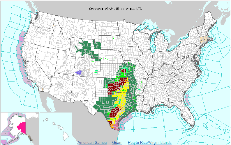
Something you don't see everyday! 
Yellow--Tornado Watch
Pink--Severe Thunderstorm Watch
Green--Flash Flood Watch
Red--Flash Flood Warning
Yellow--Tornado Watch
Pink--Severe Thunderstorm Watch
Green--Flash Flood Watch
Red--Flash Flood Warning

0 likes
The following post is NOT an official forecast and should not be used as such. It is just the opinion of the poster and may or may not be backed by sound meteorological data. It is NOT endorsed by any professional institution including storm2k.org For Official Information please refer to the NHC and NWS products.
0 likes
The above post and any post by Ntxw is NOT an official forecast and should not be used as such. It is just the opinion of the poster and may or may not be backed by sound meteorological data. It is NOT endorsed by any professional institution including Storm2k. For official information, please refer to NWS products.
Help support Storm2K!
Help support Storm2K!
Return to “USA & Caribbean Weather”
Who is online
Users browsing this forum: No registered users and 73 guests