Page 83 of 85
Re: Texas Fall-2014
Posted: Sun Nov 23, 2014 6:34 pm
by Ntxw
Portastorm wrote:That Portastorm Weather Center prediction of a major winter storm for Texas around Thanksgiving looks ... uh ... well, I hope none of you guys went to Vegas on those odds.

Hey don't feel too bad, I was with you there. Technically there could be a nor'easter along the eastern seaboard. Maybe we will see snow for the Parade in NYC. It's just not doing much passing over Texas except causing the windstorm out there currently.
Canada is frigid, we just have to wait for the pattern to buckle. The warming at 10mb and up will take a little time for develop a -AO dive.

Re: Texas Fall-2014
Posted: Sun Nov 23, 2014 9:03 pm
by aggiecutter
Portastorm wrote:That Portastorm Weather Center prediction of a major winter storm for Texas around Thanksgiving looks ... uh ... well, I hope none of you guys went to Vegas on those odds.
Not only that, you promised that Texarkana would get over 12" of snow last Monday night. I got 12 alright, 12 flakes.
Posted: Sun Nov 23, 2014 10:14 pm
by SaskatchewanScreamer
The war has just started between Houses of Targaryen and Stark...Winter 2014/15
https://www.youtube.com/watch?v=14AlnOK9WsoMay the Northern Wolf beat the Southern fire breathing Dragon into submission!
Re: Texas Fall-2014
Posted: Mon Nov 24, 2014 8:57 am
by weatherguy425
Keep an eye on the first week of December, specially December 4th - onward. EPO already back in negative territory, AO forecast to go the same direction after December 1st. Long-Range GFS (and I guess the medium range ECMWF) are hinting at a return of 'cool and unsettled weather' across the Southern Plains. And, as Ntxw already mentioned, the source regions (most of Canada, actually) are quite cold.
Re: Texas Fall-2014
Posted: Mon Nov 24, 2014 9:04 am
by Tireman4
weatherguy425 wrote:Keep an eye on the first week of December, specially December 4th - onward. EPO already back in negative territory, AO forecast to go the same direction after December 1st. Long-Range GFS (and I guess the medium range ECMWF) are hinting at a return of 'cool and unsettled weather' across the Southern Plains. And, as Ntxw already mentioned, the source regions (most of Canada, actually) are quite cold.
I was thinking mid December, but yep..stay tuned...
Re: Texas Fall-2014
Posted: Mon Nov 24, 2014 1:29 pm
by hriverajr
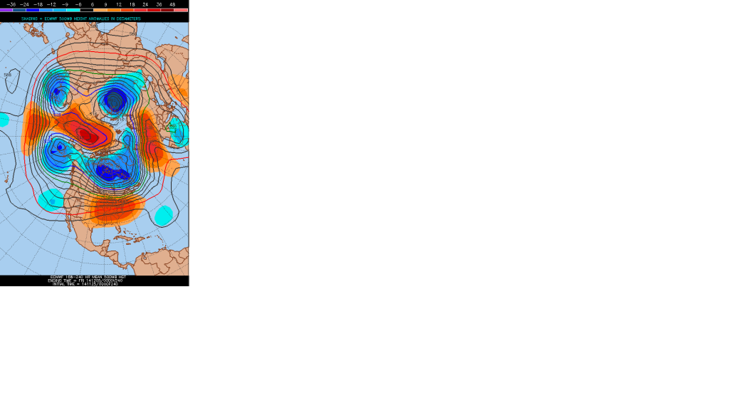
Ryan Maue tweeting about some anomalies of up to 72F below normal in western Canada potentially developing by end of month.
Re: Texas Fall-2014
Posted: Mon Nov 24, 2014 1:40 pm
by srainhoutx
hriverajr wrote:Ryan Maue tweeting about some anomalies of up to 72F below normal in western Canada potentially developing by end of month.
Blocking regime developing across the Artic via the 12Z Euro. Heights are rising fairly rapidly across the North Pole toward Alaska.
Re: Texas Fall-2014
Posted: Mon Nov 24, 2014 5:23 pm
by CaptinCrunch
AREA FORECAST DISCUSSION...CORRECTED
NATIONAL WEATHER SERVICE FORT WORTH TX
317 PM CST MON NOV 24 2014
.DISCUSSION...
QUIET...DRY...AND PLEASANT WEATHER IS EXPECTED THROUGH THE WEEKEND
MAKING FOR AN ENJOYABLE HOLIDAY WEEK.
SOME HIGH CLOUDS HAVE SPREAD ACROSS THE REGION TODAY AS ENERGY IN
THE BASE OF AN UPPER LEVEL TROUGH MOVES ACROSS THE STATE.
TEMPERATURES HAVE WARMED INTO THE UPPER 50S AND LOWER 60S WITH
MOSTLY LIGHT WINDS. LIGHT WINDS WILL CONTINUE TONIGHT AS A SURFACE
HIGH MOVES OVER THE REGION AND OVERNIGHT LOWS WILL FALL INTO THE
30S...BUT MOSTLY REMAIN ABOVE FREEZING.
ONE FINAL PIECE OF UPPER LEVEL ENERGY WILL SWING ACROSS THE REGION
TOMORROW AND THEN THE ENTIRE UPPER LEVEL TROUGH SYSTEM WILL MOVE
EAST WITH NORTHWEST FLOW PERSISTING OVERHEAD THROUGH FRIDAY. A
WEAK AND BARELY NOTICEABLE FRONT WILL SLIDE INTO THE REGION
TOMORROW BUT ITS EFFECTS WILL BE LIMITED TO BRINGING THE WINDS
BACK AROUND TO THE NORTHWEST...BUT FOR ONLY A SHORT TIME.
TEMPERATURES TOMORROW WILL BE VERY SIMILAR TO TODAY AND THEN A
WARMING TREND WILL COMMENCE.
UNDER THE INFLUENCE OF QUIET NORTHWEST FLOW ALOFT...TEMPERATURES
WILL WARM INTO THE 60S ACROSS THE REGION ON WEDNESDAY AND
THURSDAY. ANOTHER WEAK FRONT WILL PASS THROUGH ON WEDNESDAY BUT
AGAIN...ITS EFFECT WILL BE VERY MINIMAL AND MOSTLY MARKED BY A
WIND SHIFT TO THE NORTH. SOUTH AND SOUTHWEST WINDS RETURN ACROSS
THE REGION FRIDAY AND THIS WEEKEND AND WILL STRENGTHEN AS A STRONG
SURFACE LOW PRESSURE MOVES THROUGH THE NORTHERN PLAINS. THE UPPER
LEVEL FLOW WILL TRANSITION TO A ZONAL FLOW PATTERN AND
TEMPERATURES WILL CONTINUE TO WARM INTO THE UPPER 60S AND 70S
THIS WEEKEND. THE WEEKEND FORECAST WILL FEATURE WARM
TEMPERATURES...BREEZY WINDS AND INCREASING CLOUD COVER.
PREVIOUSLY...A FRONT WAS FORECAST TO ARRIVE LATE SUNDAY BUT NOW
BOTH THE GFS AND ECMWF BARELY EASE THIS FRONT INTO THE REGION
SUNDAY NIGHT BEFORE QUICKLY RETURNING IT NORTH. THIS HAPPENS IN
RESPONSE TO ANOTHER LOW PRESSURE SYSTEM DEEPENING THE LEE OF THE
ROCKIES...AHEAD OF A SHORTWAVE MOVING ACROSS THE WESTERN CONUS.
THE SHORTWAVE WILL MOVE ACROSS THE REGION SOMETIME NEXT WEEK AND
COULD BRING US RAIN CHANCES.
sounds nice doesn't it?.............But would rather have the cold of 2 weeks ago.
Re: Texas Fall-2014
Posted: Mon Nov 24, 2014 10:33 pm
by orangeblood
hriverajr wrote:Ryan Maue tweeting about some anomalies of up to 72F below normal in western Canada potentially developing by end of month.
Need the NE Pacific Ridge to deliver that insane cold into the lower 48....Euro weeklies have it invading towards the end of the 2 week period (around Dec 8-10).
The Weeklies have performed quite well over the past few runs
Re: Texas Fall-2014
Posted: Mon Nov 24, 2014 10:38 pm
by asd123
orangeblood wrote:hriverajr wrote:Ryan Maue tweeting about some anomalies of up to 72F below normal in western Canada potentially developing by end of month.
Need the NE Pacific Ridge to deliver that insane cold into the lower 48....Euro weeklies have it invading towards the end of the 2 week period (around Dec 8-10).
The Weeklies have performed quite well over the past few runs
Will it turn out to be anything like this:
http://theweathercentre.blogspot.com/20 ... ortex.html
Posted: Tue Nov 25, 2014 7:38 am
by Texas Snowman
Got another official freeze in the Red River Valley this morning - currently 31 degrees this morning with fog and mist being reported here in Denison/Sherman at 6:30 a.m.
That marks the seventh freeze for D/S so far during the month of November.
Posted: Tue Nov 25, 2014 10:36 am
by cctxhurricanewatcher
Early Winter Cancel?
So quiet.
Re: Texas Fall-2014
Posted: Tue Nov 25, 2014 10:49 am
by srainhoutx
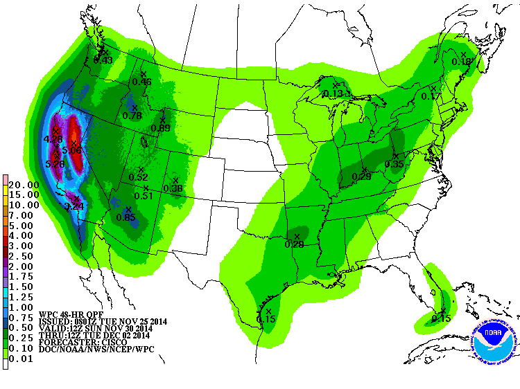
It looks like El Nino is progressing nicely and the Day 6 to 7 Quantitative Precipitation Forecast (QPF) certainly suggests a pattern we would expected as an El Nino pattern develops. The West Coast has endured a multi year significant drought and it appears the active Pacific will bring heavy higher elevation snow and lower elevation heavy rainfall beginning Sunday into Tuesday. Our rain chances should increase across our Region next week as the Pacific storm moves inland and the return flow of the Gulf becomes established with a noisy sub tropical jet overhead. We may see a rather damp first week of December.
Re:
Posted: Tue Nov 25, 2014 11:41 am
by aggiecutter
cctxhurricanewatcher wrote:Early Winter Cancel?
So quiet.
Looks like winter is cancelled for the first half of December. The EURO weeklies and operational(see below) say blow torch.
Re: Texas Fall-2014
Posted: Tue Nov 25, 2014 12:03 pm
by weatherdude1108
srainhoutx wrote:It looks like El Nino is progressing nicely and the Day 6 to 7 Quantitative Precipitation Forecast (QPF) certainly suggests a pattern we would expected as an El Nino pattern develops. The West Coast has endured a multi year significant drought and it appears the active Pacific will bring heavy higher elevation snow and lower elevation heavy rainfall beginning Sunday into Tuesday. Our rain chances should increase across our Region next week as the Pacific storm moves inland and the return flow of the Gulf becomes established with a noisy sub tropical jet overhead. We may see a rather damp first week of December.

That's great news, especially for the west (CA)!
I have some relatives that live out there who are coping with the drought. My relatives are okay on city water, but I saw reports of houses in the central valley who's wells are completely dry. Those people have to truck in water daily for basic needs. Scary eye-opening stuff.

Re:
Posted: Tue Nov 25, 2014 12:17 pm
by Texas Snowman
cctxhurricanewatcher wrote:Early Winter Cancel?
So quiet.
True, but it is also Thanksgiving Day week and lots of folks are busy with travel, finishing up work, etc.
And keep in mind that winter hasn't even technically started yet, either the calendar/meteorological version or the astronomical version.

So I'm going for "No Cancel."
Re: Texas Fall-2014
Posted: Tue Nov 25, 2014 12:31 pm
by srainhoutx
It was an epic November with regard to super Typhoon Nuri transitioning to an exratropical Super Storm that basically changed the entire November pattern on a planetary scale particularly the Northern Hemisphere. The October Eurasia snow led the way with the teleconnection indices responding and Nuri flipped the building cold over Eurasia/Siberia and delivered a record breaking extreme shot of cold air in mid-November across much of the Lower 48. Enjoy the warmup while it lasts. It was sort of fitting to end the Fall discussions with an epic Arctic Outbreak that actually continues today into tomorrow and Thanksgiving to our E as the pattern of a deep Central/Eastern trough pattern finally relaxes. Happy Thanksgiving Everyone!
Posted: Tue Nov 25, 2014 12:40 pm
by TeamPlayersBlue
Lots of football left!

Winter will be back. Cant be super cold forever
Posted: Tue Nov 25, 2014 1:10 pm
by TeamPlayersBlue
Man that is one boring 12z GFS lol. Saw a Low coming into Cali which would be beneficial for them
Re: Re:
Posted: Tue Nov 25, 2014 1:51 pm
by cctxhurricanewatcher
Texas Snowman wrote:cctxhurricanewatcher wrote:Early Winter Cancel?
So quiet.
True, but it is also Thanksgiving Day week and lots of folks are busy with travel, finishing up work, etc.
And keep in mind that winter hasn't even technically started yet, either the calendar/meteorological version or the astronomical version.
So I'm going for "No Cancel."
I will patiently wait and enjoy our current weather pattern if it helps to build the cold just in time to be released Christmas week and thereafter. Just as long as we don't have some of those freaky days in the upper 80's and 90's between now and then, I'm good.
