

Watches, Warnings or Advisories for
Texas:
http://alerts.weather.gov/cap/tx.php?x=1
Texas Spring-2015
Moderator: S2k Moderators
Forum rules

The posts in this forum are NOT official forecast and should not be used as such. They are just the opinion of the poster and may or may not be backed by sound meteorological data. They are NOT endorsed by any professional institution or STORM2K.
-
Texas Snowman

- Storm2k Moderator

- Posts: 6197
- Joined: Fri Jan 25, 2008 11:29 am
- Location: Denison, Texas
Lots of one-inch totals on radar estimate map showing up now near the Red River between Wichita Falls and Sherman. Not going to help the Texoma flood situation.
0 likes
The above post and any post by Texas Snowman is NOT an official forecast and should not be used as such. It is just the opinion of the poster and may or may not be backed by sound meteorological data. It is NOT endorsed by any professional institution including storm2k.org. For official information, please refer to NWS products.

Re: Texas Spring-2015
Looks like 4 current tornado warnings in CTX and 3 along Red River counties in NTX atm.
0 likes


Tornado Watch soon for SE TX. Be weather aware this afternoon and evening.
MESOSCALE DISCUSSION 0767
NWS STORM PREDICTION CENTER NORMAN OK
0235 PM CDT MON MAY 25 2015
AREAS AFFECTED...SERN OK/SWRN AR/E TX
CONCERNING...SEVERE POTENTIAL...TORNADO WATCH LIKELY
VALID 251935Z - 252030Z
PROBABILITY OF WATCH ISSUANCE...80 PERCENT
SUMMARY...CONTINUED EWD ADVANCE OF A WELL-ORGANIZED MCS ACROSS
CENTRAL TX AND MORE ISOLATED ROTATING STORMS EVOLVING AHEAD OF THE
LINE WILL RESULT IN AN INCREASING RISK FOR DAMAGING WINDS AND
ISOLATED TORNADOES ALONG WITH HAIL ACROSS THE MD AREA. NEW TORNADO
WATCH WILL BE REQUIRED WITHIN THE NEXT HOUR.
DISCUSSION...LATEST RADAR LOOP SHOWS WIDESPREAD STRONG/SEVERE STORMS
ACROSS CENTRAL TX -- INCLUDING A WELL-ORGANIZED BOWING MCS AND
INCREASINGLY NUMEROUS SUPERCELLS AHEAD OF THE MAIN CONVECTIVE LINE.
THE STORMS ARE MOVING THROUGH A MOIST/MODERATELY UNSTABLE
ENVIRONMENT...AND ARE BEING AIDED BY A MID-LEVEL JET STREAM CROSSING
CENTRAL TX S OF A NWRN TX/SWRN OK VORT MAX. WITH THE ENVIRONMENT E
0 likes
The following post is NOT an official forecast and should not be used as such. It is just the opinion of the poster and may or may not be backed by sound meteorological data. It is NOT endorsed by any professional institution including storm2k.org For Official Information please refer to the NHC and NWS products.

-
Texas Snowman
- Storm2k Moderator
- Posts: 6197
- Joined: Fri Jan 25, 2008 11:29 am
- Location: Denison, Texas
Been busy for a while.
I'm in Tom Bean at my father-in-law's house for Memorial Day.
Tornado may - may - have gone through a portion of Sherman and Denison.
It was reported to be on the ground by spotters and Fort Worth NWS. Went not far from my parent's house. My heart is beating 200 beats a minute.
I can't get any confirmation if it was on the ground in Denison and if it did any damage.
My
0 likes
The above post and any post by Texas Snowman is NOT an official forecast and should not be used as such. It is just the opinion of the poster and may or may not be backed by sound meteorological data. It is NOT endorsed by any professional institution including storm2k.org. For official information, please refer to NWS products.
Re: Texas Spring-2015
Tornado footage near Pidcoke, TX -- Warning expletive language.
https://www.youtube.com/watch?v=vYaM7ESytiQ
https://www.youtube.com/watch?v=vYaM7ESytiQ
0 likes
Re: Texas Spring-2015

0 likes
-
Texas Snowman
- Storm2k Moderator
- Posts: 6197
- Joined: Fri Jan 25, 2008 11:29 am
- Location: Denison, Texas
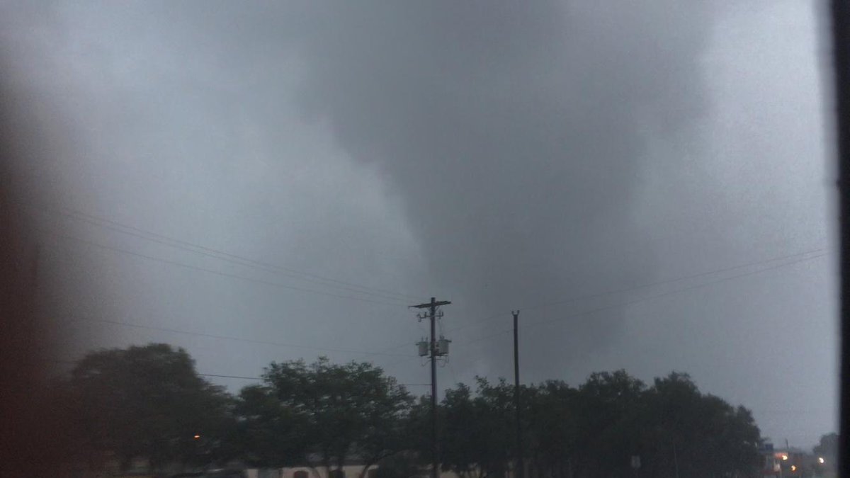
This is the storm that produced the tornado near Sherman/Denison:
-------
@tornadopayne -- 3:10pm- Confirmed strong tornado just S of Atoka moving north. Caney & Tushka stay alert! #okwx
-------
@tornadopayne -- 3:10pm- Confirmed strong tornado just S of Atoka moving north. Caney & Tushka stay alert! #okwx
0 likes
The above post and any post by Texas Snowman is NOT an official forecast and should not be used as such. It is just the opinion of the poster and may or may not be backed by sound meteorological data. It is NOT endorsed by any professional institution including storm2k.org. For official information, please refer to NWS products.

-
Texas Snowman
- Storm2k Moderator
- Posts: 6197
- Joined: Fri Jan 25, 2008 11:29 am
- Location: Denison, Texas
Re: Texas Spring-2015
Tornado lifted as it approached Denison from what I have learned. This was it passing over the east side of town.
From a friend, Josh Kelly's Facebook page:

From a friend, Josh Kelly's Facebook page:
0 likes
The above post and any post by Texas Snowman is NOT an official forecast and should not be used as such. It is just the opinion of the poster and may or may not be backed by sound meteorological data. It is NOT endorsed by any professional institution including storm2k.org. For official information, please refer to NWS products.
Re: Texas Spring-2015
Should we make a severe wx thread for today or keep it in TX Spring thread? I know some of the nastiness may stretch north across the Red River.
0 likes
Re: Texas Spring-2015
Storm going over North Austin is Radar Warned.
TORNADO WARNING
OKC005-013-252100-
/O.NEW.KOUN.TO.W.0129.150525T2032Z-150525T2100Z/
BULLETIN - EAS ACTIVATION REQUESTED
TORNADO WARNING
NATIONAL WEATHER SERVICE NORMAN OK
332 PM CDT MON MAY 25 2015
THE NATIONAL WEATHER SERVICE IN NORMAN HAS ISSUED A
* TORNADO WARNING FOR...
NORTH CENTRAL BRYAN COUNTY IN SOUTHEASTERN OKLAHOMA...
SOUTHWESTERN ATOKA COUNTY IN SOUTHEASTERN OKLAHOMA...
* UNTIL 400 PM CDT
* AT 330 PM CDT...A SEVERE THUNDERSTORM CAPABLE OF PRODUCING A
TORNADO WAS LOCATED 4 MILES SOUTHEAST OF KENEFIC...MOVING
NORTHEAST AT 30 MPH.
HAZARD...TORNADO AND GOLF BALL SIZE HAIL.
SOURCE...RADAR INDICATED ROTATION.
IMPACT...FLYING DEBRIS WILL BE DANGEROUS TO THOSE CAUGHT WITHOUT
SHELTER. MOBILE HOMES WILL BE DAMAGED OR DESTROYED.
DAMAGE TO ROOFS...WINDOWS AND VEHICLES WILL OCCUR. TREE
DAMAGE IS LIKELY.
* LOCATIONS IMPACTED INCLUDE...
CADDO...KENEFIC AND ARMSTRONG.
TORNADO WARNING
OKC005-013-252100-
/O.NEW.KOUN.TO.W.0129.150525T2032Z-150525T2100Z/
BULLETIN - EAS ACTIVATION REQUESTED
TORNADO WARNING
NATIONAL WEATHER SERVICE NORMAN OK
332 PM CDT MON MAY 25 2015
THE NATIONAL WEATHER SERVICE IN NORMAN HAS ISSUED A
* TORNADO WARNING FOR...
NORTH CENTRAL BRYAN COUNTY IN SOUTHEASTERN OKLAHOMA...
SOUTHWESTERN ATOKA COUNTY IN SOUTHEASTERN OKLAHOMA...
* UNTIL 400 PM CDT
* AT 330 PM CDT...A SEVERE THUNDERSTORM CAPABLE OF PRODUCING A
TORNADO WAS LOCATED 4 MILES SOUTHEAST OF KENEFIC...MOVING
NORTHEAST AT 30 MPH.
HAZARD...TORNADO AND GOLF BALL SIZE HAIL.
SOURCE...RADAR INDICATED ROTATION.
IMPACT...FLYING DEBRIS WILL BE DANGEROUS TO THOSE CAUGHT WITHOUT
SHELTER. MOBILE HOMES WILL BE DAMAGED OR DESTROYED.
DAMAGE TO ROOFS...WINDOWS AND VEHICLES WILL OCCUR. TREE
DAMAGE IS LIKELY.
* LOCATIONS IMPACTED INCLUDE...
CADDO...KENEFIC AND ARMSTRONG.
0 likes
-
HockeyTx82
- S2K Supporter

- Posts: 2791
- Joined: Tue Oct 27, 2009 11:17 am
- Location: Ponder, TX
Re: Texas Spring-2015
So for my own interest why with such a high threat (4 out of 5) of severe weather today has it been rather tame to other days when have been in a lower risk? I know that forecasting is not perfect but my concern is when such high risks are posted and it does not materialize the general public might a false sense for when things really start cranking. Did we not warm up as much as we thought? Have we had so much weather of late my expected level of severe is now higher? It seems things were more south this time. Hope everyone stays safe.
Last edited by HockeyTx82 on Mon May 25, 2015 3:40 pm, edited 1 time in total.
0 likes
Don't hold me accountable for anything I post on this forum. Leave the real forecasting up to the professionals.
Location: Ponder, TX (all observation posts are this location unless otherwise noted)
Location: Ponder, TX (all observation posts are this location unless otherwise noted)

-
Texas Snowman
- Storm2k Moderator
- Posts: 6197
- Joined: Fri Jan 25, 2008 11:29 am
- Location: Denison, Texas
Re: Texas Spring-2015
HockeyTx82 wrote:So for my own interest why with such a high threat (4 out of 5) of severe weather today has it been rather tame to other days when have been in a lower risk? I know that forecasting is not perfect but my concern is when such high risks are posted and it does not materialize the general public might a false sense for when things really start cranking. Did we not warm up as much as we thought? Have we had so much weather of late my expected level of severe is now higher? It seems things were more south this time. Hope everyone stays safe.
Having had a tornado/funnel cloud move directly over Sherman and Denison this afternoon, I'd say it was pretty good.
Keep in mind that the moderate risk is for severe weather, not just for tornadoes. The tornado threat was always from supercells that could get going in front of the MCS (which is what happened in central Texas and in Grayson County).
Spin-up tornadoes, hail, torrential rains and damaging straight line winds were the biggest threats with the MCS and I'd say that delivered as well.
0 likes
The above post and any post by Texas Snowman is NOT an official forecast and should not be used as such. It is just the opinion of the poster and may or may not be backed by sound meteorological data. It is NOT endorsed by any professional institution including storm2k.org. For official information, please refer to NWS products.
Return to “USA & Caribbean Weather”
Who is online
Users browsing this forum: Stratton23 and 56 guests