Page 2 of 3
Re: Potential Severe Weather Event; 2/28, 3/1; Mid South
Posted: Tue Feb 28, 2017 1:26 pm
by TheProfessor
Got Radarscope a few days ago, looks like this would be a good event to put it to use, but it seems like a lot of the storms will be at night and I have 9 AM class tomorrow. sigh

Re: Potential Severe Weather Event; 2/28, 3/1; Mid South
Posted: Tue Feb 28, 2017 1:53 pm
by cycloneye
PUBLIC SEVERE WEATHER OUTLOOK
NWS STORM PREDICTION CENTER NORMAN OK
1050 AM CST TUE FEB 28 2017
...Severe thunderstorms expected over parts of the Ozarks region to
the Ohio Valley late this afternoon into tonight...
* LOCATIONS...
Indiana
Western and northern Kentucky
Southern and eastern Missouri
Illinois
Northern Arkansas
Northwest Tennessee
Far western Ohio
* HAZARDS...
Several tornadoes, a few intense
Widespread large hail, some baseball size
Scattered damaging winds
* SUMMARY...
Severe thunderstorms are expected to develop from portions of
the lower Mississippi Valley to the Ohio Valley through tonight.
Strong tornadoes will be possible, especially across portions of
the lower and middle Ohio Valley. Otherwise, large hail and
damaging winds are expected.
Preparedness actions...
Review your severe weather safety procedures for the possibility
of dangerous weather today. Stay tuned to NOAA Weather Radio,
weather.gov, or other media for watches and warnings. A tornado
watch means that conditions are favorable for tornadoes to form
during the next several hours. If a tornado warning is issued for
your area, move to a place of safety, ideally in a basement or
interior room on the lowest floor of a sturdy building.
&&
..Cohen.. 02/28/2017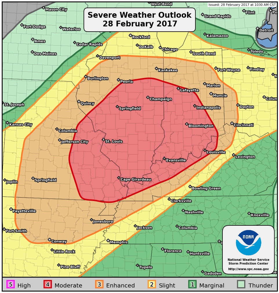
Re: Potential Severe Weather Event; 2/28, 3/1; Mid South
Posted: Tue Feb 28, 2017 1:58 pm
by EF-5bigj
PDS watch?
Re: Potential Severe Weather Event; 2/28, 3/1; Mid South
Posted: Tue Feb 28, 2017 3:26 pm
by EF-5bigj
http://www.spc.noaa.gov/products/watch/ww0041.html First tornado watch mentions "A couple of intense tornadoes possible"
Re: Potential Severe Weather Event; 2/28, 3/1; Mid South
Posted: Tue Feb 28, 2017 3:26 pm
by cycloneye
Tornado Watch issued
URGENT - IMMEDIATE BROADCAST REQUESTED
Tornado Watch Number 41
NWS Storm Prediction Center Norman OK
215 PM CST Tue Feb 28 2017
The NWS Storm Prediction Center has issued a
* Tornado Watch for portions of
Southern and West-Central Illinois
Extreme Southeast Kansas
Central and Southern Missouri
* Effective this Tuesday afternoon and evening from 215 PM until
900 PM CST.
* Primary threats include...
A few tornadoes likely with a couple intense tornadoes possible
Scattered large hail likely with isolated very large hail events
to 3 inches in diameter possible
Scattered damaging wind gusts to 70 mph possible
SUMMARY...Widely scattered thunderstorms are expected to affect the
watch area this afternoon and evening, with a few severe storms
likely. Very large hail and isolated tornadoes will be possible in
the more intense storms.
The tornado watch area is approximately along and 70 statute miles
north and south of a line from 10 miles west northwest of Joplin MO
to 25 miles south southeast of Mount Vernon IL. For a complete
depiction of the watch see the associated watch outline update
(WOUS64 KWNS WOU1).
PRECAUTIONARY/PREPAREDNESS ACTIONS...
REMEMBER...A Tornado Watch means conditions are favorable for
tornadoes and severe thunderstorms in and close to the watch
area. Persons in these areas should be on the lookout for
threatening weather conditions and listen for later statements
and possible warnings.
&&
AVIATION...Tornadoes and a few severe thunderstorms with hail
surface and aloft to 3 inches. Extreme turbulence and surface wind
gusts to 60 knots. A few cumulonimbi with maximum tops to 450. Mean
storm motion vector 25035.
...Hart
Re: Potential Severe Weather Event; 2/28, 3/1; Mid South
Posted: Tue Feb 28, 2017 3:41 pm
by JDawg512
So since there's nothing going on here in my neck of the woods, guess I'll monitor this thread. Looks like there's a couple of severe storm warnings southwest of St. Louis.
Re: Potential Severe Weather Event; 2/28, 3/1; Mid South
Posted: Tue Feb 28, 2017 4:10 pm
by EF-5bigj
New watch out
Re: Potential Severe Weather Event; 2/28, 3/1; Mid South
Posted: Tue Feb 28, 2017 4:14 pm
by cycloneye
Re: Potential Severe Weather Event; 2/28, 3/1; Mid South
Posted: Tue Feb 28, 2017 4:19 pm
by cycloneye
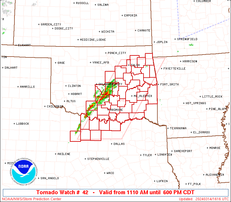
Almost all of Illinois under Tornado Watch that includes Chicago.
URGENT - IMMEDIATE BROADCAST REQUESTED
Tornado Watch Number 42
NWS Storm Prediction Center Norman OK
300 PM CST Tue Feb 28 2017
The NWS Storm Prediction Center has issued a
* Tornado Watch for portions of
Southeast Iowa
Northern and Central Illinois
Northwest Indiana
Northeast Missouri
Lake Michigan
* Effective this Tuesday afternoon and evening from 300 PM until
1000 PM CST.
* Primary threats include...
A few tornadoes possible
Scattered large hail likely with isolated very large hail events
to 3 inches in diameter possible
Scattered damaging wind gusts to 70 mph possible
SUMMARY...Scattered thunderstorms are expected to form this
afternoon and early evening across the watch area. Conditions
appear favorable for large hail in the stronger cells, along with
the risk for isolated tornadoes.
The tornado watch area is approximately along and 120 statute miles
north and south of a line from 35 miles south of Ottumwa IA to 30
miles north of Lafayette IN. For a complete depiction of the watch
see the associated watch outline update (WOUS64 KWNS WOU2).
Re: Potential Severe Weather Event; 2/28, 3/1; Mid South
Posted: Tue Feb 28, 2017 4:35 pm
by WeatherGuesser
Since it isn't going south of 36N, keep it north of 38N. I have no interest in dealing with it.
Soupy as all get out right now; feels like July.
Re: Potential Severe Weather Event; 2/28, 3/1; Mid South
Posted: Tue Feb 28, 2017 4:48 pm
by EF-5bigj
New watch in ARK..
Re: Potential Severe Weather Event; 2/28, 3/1; Mid South
Posted: Tue Feb 28, 2017 5:21 pm
by cycloneye
Re: Potential Severe Weather Event; 2/28, 3/1; Mid South
Posted: Tue Feb 28, 2017 5:39 pm
by cycloneye
Re: Potential Severe Weather Event; 2/28, 3/1; Mid South
Posted: Tue Feb 28, 2017 5:44 pm
by cycloneye
Re: Potential Severe Weather Event; 2/28, 3/1; Mid South
Posted: Tue Feb 28, 2017 6:25 pm
by EF-5bigj
There is a violent tornado ongoing in Illinois right now.

Re: Potential Severe Weather Event; 2/28, 3/1; Mid South
Posted: Tue Feb 28, 2017 6:28 pm
by WeatherGuesser
Twin hooks moving towards Little Rock, AR.
Re: Potential Severe Weather Event; 2/28, 3/1; Mid South
Posted: Tue Feb 28, 2017 6:40 pm
by cycloneye
Re: Potential Severe Weather Event; 2/28, 3/1; Mid South
Posted: Tue Feb 28, 2017 7:21 pm
by cycloneye
Re: Potential Severe Weather Event; 2/28, 3/1; Mid South
Posted: Tue Feb 28, 2017 7:32 pm
by cycloneye
Re: Potential Severe Weather Event; 2/28, 3/1; Mid South
Posted: Tue Feb 28, 2017 8:18 pm
by WeatherGuesser
MDT extended further west across MO.