Ingredients coming together to produce several days of scattered to numerous heavy showers and thunderstorms across the region.
Upper level ridges are located over northern MX and across the SE US this morning with a “break” or “weakness” in between the ridges over much of TX. This shear or trough axis is resulting in a thermodynamically favorable environment for thunderstorm development with low convective (trigger) temperatures in the low to mid 80’s and no capping aloft. Additionally, a stream of mid and high level moisture is pouring NNE from the eastern Pacific Ocean trapped in this weakness between the high pressure ridges. A surge of deep tropical moisture is quickly arriving on the TX coast this morning with GPS data showing PWS values pushing 2.0-2.1 inches from S TX northward into the coastal bend…which is slightly higher than models were forecasting. The high PWS alone with weak capping would support high rain chances, but couple that with weak short wave roaming across the state within the broad shear axis adds even more lift for widespread rainfall.
On the meso scale a weak boundary is noted both in radar images and data analysis on the theta E profiles extending from roughly Waco to north of Fort Polk, LA where recently thunderstorms have developed. Out west across SW TX into the rolling plains of west TX (Del Rio to east of Midland) an ESE moving MCS (thunderstorm complex) appears to be increasing in intensity some and supported by an eastward moving short wave. Locally, northward moving showers have crossed eastern Galveston Island this morning and moved inland around Matagorda Bay as a result of the increasing tropical air mass moving northward off the western Gulf.
Given all the above triggers (near northern boundary, approaching SW TX short wave, and inland moving seabreeze front) coupled with a few hours of daytime heating and expect numerous thunderstorms to result. Should start to see development near the coast/just inland in the next few hours with a rapid expansion of storms near area-wide as surface temperatures warm into the mid 80’s around 1000am-noon. Not sure if any of the meso models are going to get much correct over the next few days as they were too dry yesterday. For what it is worth the HRRR seems to like the US 59 corridor today and actually keeps our northern counties fairly dry.
Wednesday-Thursday:
Models are attempting to peg the area pretty good with high QPF during this window as deep tropical moisture will be in place (PWS 2.0-2.2 inches). Think we will see a transition to late night/early morning development near the coast/offshore as low level speed convergence is maximized in the midnight-300am range and this tends to be a favored development time in such tropical air masses. Storms will develop offshore and near the coast and spread inland during the morning hours possibly helped along by incoming weak short waves aloft which currently are not seen. Hard to pin point where and when the greatest activity will occur as the weather over the next 3-4 days will be nearly completely meso scale driven along outflow boundaries. TX TECH WRF shows a good bit of development Wednesday with some slow moving clustering of storms over our central counties along the US 59 and I-10 corridors.
Rainfall:
Air mass will be certainly capable of excessive rainfall given a near saturated air column and high PW air mass. Storm motions will also becoming increasing slow with weakening steering winds aloft and much of their forward motions being driven by outflow boundaries. Concern will be with any cell training of overall storm organization (such as a slowing moving line of storms or slow moving MCS) which would be very capable of putting down several inches of rainfall in a short amount of time. 3-hr flash flood guidance ranges from 2.0-4.0 inches across much of the area. Slow moving organized storms will be capable of exceeding the flash flood guidance values across the area and generating run-off. Additional concern will be high hourly rainfall rates (1-3 inches) in the urban areas which will quickly result in street flooding.
Storm totals not including yesterday will likely average 1-3 inches with isolated amounts upwards of 6 inches by the end of the week. Could see a few isolated locations (as seen on Sunday SW of Fort Worth) pick up 8-10 inches. This air mass and pattern in place is very much capable of producing some really big rainfall totals in a short amount of time under slow moving strong thunderstorms.
Texas Summer - 2014
Moderator: S2k Moderators
Forum rules

The posts in this forum are NOT official forecast and should not be used as such. They are just the opinion of the poster and may or may not be backed by sound meteorological data. They are NOT endorsed by any professional institution or STORM2K.
-
gboudx

- S2K Supporter

- Posts: 4090
- Joined: Thu Sep 04, 2003 1:39 pm
- Location: Rockwall, Tx but from Harvey, La
From Jeff:
0 likes
-
wxman57

- Moderator-Pro Met

- Posts: 23172
- Age: 68
- Joined: Sat Jun 21, 2003 8:06 pm
- Location: Houston, TX (southwest)
Re: Texas Summer - 2014
Ntxw wrote:
Kudos to you! As painful as it was I'm sure, you didn't take the easy forecast! I'm sure you took a deep look at the Pacific Ocean, the big engine! Now how about going on a limb and forecast a 2 feet snowstorm for Houston in December??? I'm sure you can do that right?
I'm still holding out for hot and dry next December, particularly the 6th-12th when we'll be at Disneyworld.
0 likes
-
Tireman4

- S2K Supporter
- Posts: 5903
- Age: 60
- Joined: Fri Jun 30, 2006 1:08 pm
- Location: Humble, Texas
- Contact:
Re: Texas Summer - 2014
wxman57 wrote:Ntxw wrote:
Kudos to you! As painful as it was I'm sure, you didn't take the easy forecast! I'm sure you took a deep look at the Pacific Ocean, the big engine! Now how about going on a limb and forecast a 2 feet snowstorm for Houston in December??? I'm sure you can do that right?
I'm still holding out for hot and dry next December, particularly the 6th-12th when we'll be at Disneyworld.
Yeah, but that is Florida, not here. We can have a snowstorm. You can enjoy Mouseworld. Works for all us.
0 likes
-
srainhoutx

- S2K Supporter
- Posts: 6919
- Age: 68
- Joined: Sun Jan 14, 2007 11:34 am
- Location: Haywood County, NC
- Contact:
Re: Texas Summer - 2014
From Nesdis:
SATELLITE PRECIPITATION ESTIMATES..DATE/TIME 06/24/14 1612Z
SATELLITE ANALYSIS BRANCH/NESDIS---NPPU---TEL.301-683-1404
LATEST DATA USED: GOES-13 1600Z WARREN
.
LOCATION...TEXAS...
.
ATTN WFOS...SHV...HGX...FWD...OUN...SJT...
ATTN RFCS...LMRFC...ABRFC...WGRFC...
.
EVENT...LOCALLY HEAVY RAINS THIS AFTERNOON/EVENING AHEAD OF MCV
.
SATELLITE ANALYSIS AND TRENDS...MCV IS SEEN TRACKING SE AS MCS ACROSS
TX PANHANDLE CONTINUES TO DISSIPATE. THIS FEATURE IS APPROACHING AN
AXIS OF MODEST LLVL CONFLUENCE WITH A SFC BOUNDARY DRAPED WNW TO ESE
ACROSS N-CENTRAL/CENTRAL TO ERN TX. LATEST VISIBLE SATELLITE IMAGERY IS
SHOWING INCREASING CU DEVELOPMENT ALONG THIS BOUNDARY WHERE PW MOISTURE
HAS POOLED TO 1.5-1.6". ADDITIONAL HIGHER MOISTURE VALUES ARE SLOWLY
SURGING NWD WITHIN SERLY 85H FLOW AND THIS TREND SHOULD PERSIST THROUGHOUT
THE AFTERNOON INTO EVENING HRS. SHORTWAVE IMPULSE IS SLOWLY DROPPING
SE AND THIS SHOULD AID IN ENHANCING VERTICAL ASCENT ALONG THE BOUNDARY.
WATER VAPOR DOES SHOW RELATIVELY DRY AIR ALOFT...THIS IS ALSO NOTED
IN 12Z RAOB FROM FWD WHICH WOULD SUPPORT COLD POOL DEVELOPMENT AND
ORGANIZED CONVECTION TRENDING MORE PROGRESSIVE IN NATURE. INITIAL
STORMS...PARTICULARLY AHEAD OF MCV FEATURE MAY BE SLOW-MOVING GIVEN
WEAK STEERING FLOW ACROSS THE REGION. THIS COULD HELP SUPPORT LOCALIZED
HEAVY RAINFALL AMOUNTS BETWEEN 18-00Z.
.
AN ANNOTATED SATELLITE GRAPHIC SHOWING THE HEAVY PRECIPITATION
THREAT AREA SHOULD BE AVAILABLE ON THE INTERNET ADDRESS LISTED
BELOW IN APPROXIMATELY 10-15 MINUTES.
.
SHORT TERM OUTLOOK VALID 1610-2210Z...MEDIUM CONFIDENCE FACTOR
IN SHORT TERM OUTLOOK...CONFIDENCE IS INCREASING WITH POTENTIAL FOR
HEAVY RAINS ALONG A NARROW CORRIDOR EXTENDING FROM JUST E OF SNK TO JSO.
AVAILABLE MOISTURE WOULD SUGGEST RAINFALL RATES NEAR 2.0"/HR AT TIMES.
LIMITING FACTOR FOR WIDESPREAD HEAVY RAINFALL WOULD BE ANY ORGANIZED
CONVECTIVE CLUSTER THAT DEVELOPS SHOULD BECOME RELATIVELY PROGRESSIVE AND
GRAVITATE TOWARD THE S AND E WHERE BEST MOISTURE INFLOW AND INSTABILITY
IS LOCATED. HOWEVER LOCALIZED HEAVY RAINFALL FROM INITIALLY SLOW-MOVING
CELLS/MERGERS COULD RESULT IN 2-3" AMOUNTS.
.
0 likes
Carla/Alicia/Jerry(In The Eye)/Michelle/Charley/Ivan/Dennis/Katrina/Rita/Wilma/Ike/Harvey
Member: National Weather Association
Wx Infinity Forums
http://wxinfinity.com/index.php
Facebook.com/WeatherInfinity
Twitter @WeatherInfinity
Member: National Weather Association
Wx Infinity Forums
http://wxinfinity.com/index.php
Facebook.com/WeatherInfinity
Twitter @WeatherInfinity
-
South Texas Storms

- Professional-Met

- Posts: 4256
- Joined: Thu Jun 24, 2010 12:28 am
- Location: Houston, TX
Re: Texas Summer - 2014
weatherdude1108 wrote:JDawg512 wrote:Well, here we go again. EWX has pulled back rain chances and siding with a drier long range forecast. I don't like this back and forth crud.
I saw that too.
The models were trending much drier across central Texas last night. However, today's 12z runs are much wetter across our area.
Plus, the seabreeze boundary is active this afternoon with a line of showers and storms moving northwest towards Austin and San Antonio.
0 likes
-
srainhoutx
- S2K Supporter
- Posts: 6919
- Age: 68
- Joined: Sun Jan 14, 2007 11:34 am
- Location: Haywood County, NC
- Contact:
Re: Texas Summer - 2014
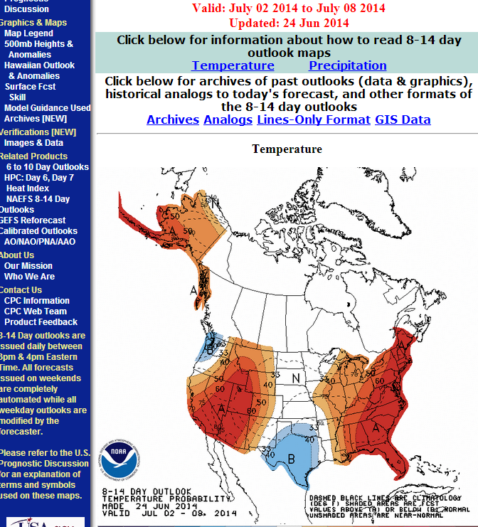
I have noticed some rather interesting trends that past several days as we head toward the end of June and the beginning of July regarding a potentially wet to very wet pattern. There are growing indications that possibly the strongest MJO pulse of the season as well as a very stout Kelvin wave will transition E into the Eastern Pacific and arrive in the western part of the Atlantic Basin ( Western Gulf/NW Caribbean Sea ) near the 4th of July.
If the operational and ensemble guidance is correct beyond the medium range, increasing rain chances could develop with even a tropical disturbance near our part of the world. The Climate Prediction Center is forecasting below normal temperatures and above normal precipitation for most of Texas extending into the July 10th time frame. That would tend to suggest that the arriving MJO pulse/KW may have legs and offer a pattern much different than what we have experienced the past 3-4 years.
Also the 12Z suite of guidance is continuing to advertise a wet pattern into the weekend and little in the way of Ridging developing over our part of the world. The shorter range meso guidance continue to ‘sniff’ a robust 700 to 500mb vort moving off the Gulf on Thursday into Friday dropping very heavy rainfall. The trough/shear axis does not appear to move which raises an eyebrow and there are indications that the EPAC may see a tropical cyclone develop and hug the Pacific Coast of Mexico as well as lower pressures from the Bay of Campeche extending N along the trough axis into Texas and Louisiana.
0 likes
Carla/Alicia/Jerry(In The Eye)/Michelle/Charley/Ivan/Dennis/Katrina/Rita/Wilma/Ike/Harvey
Member: National Weather Association
Wx Infinity Forums
http://wxinfinity.com/index.php
Facebook.com/WeatherInfinity
Twitter @WeatherInfinity
Member: National Weather Association
Wx Infinity Forums
http://wxinfinity.com/index.php
Facebook.com/WeatherInfinity
Twitter @WeatherInfinity
-
Portastorm

- Storm2k Moderator

- Posts: 9955
- Age: 63
- Joined: Fri Jul 11, 2003 9:16 am
- Location: Round Rock, TX
- Contact:
Re: Texas Summer - 2014
Our old friend, the seabreeze front, is chugging northwest. If it holds, we'll get some welcomed rains here in Austin about 3:30 p.m. or so.
I was quite pleased to read srainhoutx and South Texas Storms posts above. Bring the rain!
I was quite pleased to read srainhoutx and South Texas Storms posts above. Bring the rain!
0 likes
Any forecasts under my name are to be taken with a grain of salt. Get your best forecasts from the National Weather Service and National Hurricane Center.
-
Ralph's Weather
- S2K Supporter
- Posts: 3371
- Age: 38
- Joined: Fri Dec 13, 2013 11:55 am
- Location: Lindale, TX
- Contact:
I-20 through East Texas is really getting it right now. Heavy rain here in Tyler.
I too am glad that we look to be in a continued moisture rich airmass. We may be in the midst of one of the cooler 18 month periods in a long time from the beginning of last winter through next winter. The chances of no 100 degree days in my area are beginning to look good, but it doesn't take much to do it if we get a dry couple weeks in late summer.
I too am glad that we look to be in a continued moisture rich airmass. We may be in the midst of one of the cooler 18 month periods in a long time from the beginning of last winter through next winter. The chances of no 100 degree days in my area are beginning to look good, but it doesn't take much to do it if we get a dry couple weeks in late summer.
0 likes
Follow on Facebook at Ralph's Weather.
-
Ralph's Weather
- S2K Supporter
- Posts: 3371
- Age: 38
- Joined: Fri Dec 13, 2013 11:55 am
- Location: Lindale, TX
- Contact:
The storm over Tyler has reached severe levels. Getting heavy rain and frequent lighting here. There is potential for large hail and strong winds.
0 likes
Follow on Facebook at Ralph's Weather.
-
BrokenGlassRepublicn
- Category 1

- Posts: 483
- Joined: Sun Nov 20, 2011 8:07 pm
- Location: Richardson, Texas
-
Portastorm
- Storm2k Moderator
- Posts: 9955
- Age: 63
- Joined: Fri Jul 11, 2003 9:16 am
- Location: Round Rock, TX
- Contact:
Re:
BrokenGlassRepublicn wrote:Ft. Worth is getting DUMPED ON right now. Sure wish that had setup about 40 miles to the ENE, over Lavon Lake.
Yeah, I'm seeing some photos of the deluge on Twitter. They are definitely getting dumped on. That evening commute home is going to be miserable for the western part of the Metroplex.
0 likes
Any forecasts under my name are to be taken with a grain of salt. Get your best forecasts from the National Weather Service and National Hurricane Center.
-
weatherdude1108
- Category 5

- Posts: 4228
- Joined: Tue Dec 13, 2011 1:04 pm
- Location: Northwest Austin/Cedar Park, TX

Re: Texas Summer - 2014
The EPAC is about to kick it up a gear with a strong MJO kelvin wave well advertised by other posters here. The nation is going to feel it's first heat wave (MS river valley and Ohio River valley), while Texas is going to be influence by the weakness below and to the west of these ridges. Models are abysmal especially the GFS, likely not responding to the local features and overall strength of the MJO.
Everything is connected and El Nino is the dominant player. The deeper into the year we go the more it will control the weather.

Everything is connected and El Nino is the dominant player. The deeper into the year we go the more it will control the weather.
0 likes
The above post and any post by Ntxw is NOT an official forecast and should not be used as such. It is just the opinion of the poster and may or may not be backed by sound meteorological data. It is NOT endorsed by any professional institution including Storm2k. For official information, please refer to NWS products.
Help support Storm2K!
-
high_lander
- Tropical Low

- Posts: 34
- Joined: Tue Jan 01, 2013 7:02 pm
- Location: Little Elm, TX
-
high_lander
- Tropical Low
- Posts: 34
- Joined: Tue Jan 01, 2013 7:02 pm
- Location: Little Elm, TX
Re:
high_lander wrote:Pardon my ignorance, but I thought Joe B. killed the notion of a El Nino this year.
Personally I say bring it on, but is he wrong on this one?
This is what a classic El Nino looks like

This is what the current Pacific looks like

It just has to persist several more months. He can call it what he wants, but hard to argue that.
0 likes
The above post and any post by Ntxw is NOT an official forecast and should not be used as such. It is just the opinion of the poster and may or may not be backed by sound meteorological data. It is NOT endorsed by any professional institution including Storm2k. For official information, please refer to NWS products.
Help support Storm2K!
Help support Storm2K!
-
somethingfunny

- ChatStaff

- Posts: 3926
- Age: 37
- Joined: Thu May 31, 2007 10:30 pm
- Location: McKinney, Texas
Re: Texas Summer - 2014
Oh, Garland... how does a subsidence punch-hole like this even happen? 


Last edited by somethingfunny on Tue Jun 24, 2014 8:00 pm, edited 1 time in total.
0 likes
I am not a meteorologist, and any posts made by me are not official forecasts or to be interpreted as being intelligent. These posts are just my opinions and are probably silly opinions.
-
Portastorm
- Storm2k Moderator
- Posts: 9955
- Age: 63
- Joined: Fri Jul 11, 2003 9:16 am
- Location: Round Rock, TX
- Contact:
Re:
high_lander wrote:Pardon my ignorance, but I thought Joe B. killed the notion of a El Nino this year.
Personally I say bring it on, but is he wrong on this one?
He has stated publicly that a strong or super Nino is unlikely. He has not "killed the notion of a El Nino this year." I believe he is suggesting something like a modoki Nino.
OK, I just wanted to clarify ... let's get back to Texas summer weather!
0 likes
Any forecasts under my name are to be taken with a grain of salt. Get your best forecasts from the National Weather Service and National Hurricane Center.
-
aggiecutter
- Category 5
- Posts: 1755
- Joined: Thu Oct 14, 2004 9:22 pm
- Location: Texarkana
Re: Texas Summer - 2014
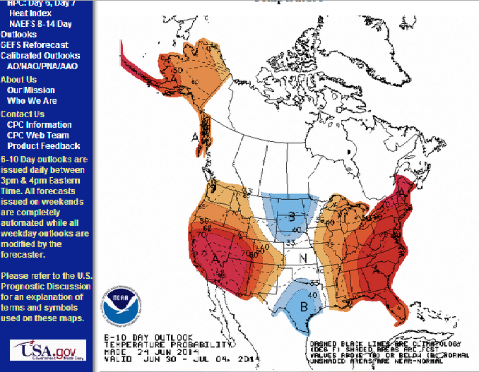
Looks like Texas will be an island of cool in a sea of warmth the next few weeks:


0 likes
Return to “USA & Caribbean Weather”
Who is online
Users browsing this forum: A1A, CaptinCrunch, Stratton23, txtwister78 and 163 guests