Texas Spring-2015

U.S. & Caribbean Weather Discussions and Severe Weather Events

Moderator: S2k Moderators

Forum rules

The posts in this forum are NOT official forecast and should not be used as such. They are just the opinion of the poster and may or may not be backed by sound meteorological data. They are NOT endorsed by any professional institution or STORM2K.

Help Support Storm2K
Message
Author
weatherdude1108
Category 5
Category 5
Posts: 4228
Joined: Tue Dec 13, 2011 1:04 pm
Location: Northwest Austin/Cedar Park, TX

Re: Texas Spring-2015

#2021 Postby weatherdude1108 » Tue Jun 02, 2015 3:44 pm

cheezyWXguy wrote:
aggiecutter wrote::uarrow: You show back-up and the Omega Block and Drought return to Texas. I always figured there was a correlation between the two.

Image


Is this reasonable? From what I've heard recently, the ridge is supposed to flatten out and shift west a bit next week. I imagine this would allow for at least low rain chances with NW flow becoming established. Additionally, couldn't moisture from Andres and Blanca in the EPAC become a factor at some point?


I was wondering about the EPAC hurricane moisture and the NW flow. Seems the pattern as of June 1st caused the "faucet" to shut off. :roll: I know a lot of us need a break from the flooding and to clean up. Lake Travis in our area is amazingly almost average and within 10-15 feet of its full pool elevation. Buchanan is 25 feet below average, nowhere near its full elevation. So ideally, we need the next rain event to park over Buchanan. :wink:
0 likes   

aggiecutter
Category 5
Category 5
Posts: 1753
Joined: Thu Oct 14, 2004 9:22 pm
Location: Texarkana

Re: Texas Spring-2015

#2022 Postby aggiecutter » Tue Jun 02, 2015 4:40 pm

Todd Warren NBC 6
1 hr ·
National Weather Service indicates that this was the wettest spring on record for Texarkana. 25.79" fell which is 12.56" or 195% above normal
0 likes   

User avatar
Texas Snowman
Storm2k Moderator
Storm2k Moderator
Posts: 6179
Joined: Fri Jan 25, 2008 11:29 am
Location: Denison, Texas

#2023 Postby Texas Snowman » Tue Jun 02, 2015 4:50 pm

FYI, Lake Texoma is finally starting its slow fall back towards normal level.

The reservoir crested at 3 a.m. yesterday morning at 645.66 feet above sea level. That's not quite a foot beyond the previous record of 644.76 (May 1990). That's also 5.66 feet of water rolling over the spillway.

If any of you North Texas residents get a chance to make it up to Denison Dam in the next week or so, it's quite the sight to see the water rolling over the spillway by several feet. Equally impressive to see the floodgates wide open and Spillway Creek - which blew out the Hwy. 91 bridge - surging towards the Red River.

Image
Last edited by Texas Snowman on Tue Jun 02, 2015 4:57 pm, edited 1 time in total.
0 likes   
The above post and any post by Texas Snowman is NOT an official forecast and should not be used as such. It is just the opinion of the poster and may or may not be backed by sound meteorological data. It is NOT endorsed by any professional institution including storm2k.org. For official information, please refer to NWS products.

Brent
S2K Supporter
S2K Supporter
Posts: 38088
Age: 36
Joined: Sun May 16, 2004 10:30 pm
Location: Tulsa Oklahoma
Contact:

Re: Texas Spring-2015

#2024 Postby Brent » Tue Jun 02, 2015 4:55 pm

weatherdude1108 wrote:
cheezyWXguy wrote:
aggiecutter wrote::uarrow: You show back-up and the Omega Block and Drought return to Texas. I always figured there was a correlation between the two.

Image


Is this reasonable? From what I've heard recently, the ridge is supposed to flatten out and shift west a bit next week. I imagine this would allow for at least low rain chances with NW flow becoming established. Additionally, couldn't moisture from Andres and Blanca in the EPAC become a factor at some point?


I was wondering about the EPAC hurricane moisture and the NW flow. Seems the pattern as of June 1st caused the "faucet" to shut off. :roll: I know a lot of us need a break from the flooding and to clean up. Lake Travis in our area is amazingly almost average and within 10-15 feet of its full pool elevation. Buchanan is 25 feet below average, nowhere near its full elevation. So ideally, we need the next rain event to park over Buchanan. :wink:


I was seeing strong hints of rain mid-late next week but the last few GFS runs have been nearly bone dry... and then there's this, which was a below normal bubble over Texas yesterday:

Image

Sigh... when is fall?
0 likes   
#neversummer

User avatar
Texas Snowman
Storm2k Moderator
Storm2k Moderator
Posts: 6179
Joined: Fri Jan 25, 2008 11:29 am
Location: Denison, Texas

#2025 Postby Texas Snowman » Tue Jun 02, 2015 5:01 pm

I'm sure we'll have some hot weather this summer. And I'm sure it will warm up over the next few days, after all, it is June.

But I'm not buying any June heat waves. Way too much water in area lakes, rivers and ponds, not to mention the ground.

And just glancing outside, plenty of puffy clouds dotting the sky, further evidence that moisture abounds at the moment. And that no death ridge is going to be able to set up shop anytime soon.
0 likes   
The above post and any post by Texas Snowman is NOT an official forecast and should not be used as such. It is just the opinion of the poster and may or may not be backed by sound meteorological data. It is NOT endorsed by any professional institution including storm2k.org. For official information, please refer to NWS products.

Brent
S2K Supporter
S2K Supporter
Posts: 38088
Age: 36
Joined: Sun May 16, 2004 10:30 pm
Location: Tulsa Oklahoma
Contact:

Re: Texas Spring-2015

#2026 Postby Brent » Tue Jun 02, 2015 5:07 pm

Larry Mowry on CBS 11 just said Blanca will increase rain chances next week
0 likes   
#neversummer

User avatar
ravyrn
S2K Supporter
S2K Supporter
Posts: 1000
Age: 42
Joined: Sun Aug 31, 2008 5:10 am
Location: Alderbranch, TX

Re:

#2027 Postby ravyrn » Wed Jun 03, 2015 1:12 am

Texas Snowman wrote:FYI, Lake Texoma is finally starting its slow fall back towards normal level.

The reservoir crested at 3 a.m. yesterday morning at 645.66 feet above sea level. That's not quite a foot beyond the previous record of 644.76 (May 1990). That's also 5.66 feet of water rolling over the spillway.

If any of you North Texas residents get a chance to make it up to Denison Dam in the next week or so, it's quite the sight to see the water rolling over the spillway by several feet. Equally impressive to see the floodgates wide open and Spillway Creek - which blew out the Hwy. 91 bridge - surging towards the Red River.

Image


Where was the Hwy. 91 bridge located? Was it the earthen roadway over the Spillway's creek?

EDIT: Nevermind, found a news article/video showing the roadways destruction: http://www.kxii.com/home/headlines/Officials-address-public-safety-concerns-as-tourists-flock-to-Lake-Texoma-305253361.html
0 likes   

weatherdude1108
Category 5
Category 5
Posts: 4228
Joined: Tue Dec 13, 2011 1:04 pm
Location: Northwest Austin/Cedar Park, TX

Re: Texas Spring-2015

#2028 Postby weatherdude1108 » Wed Jun 03, 2015 6:36 am

Brent wrote:Larry Mowry on CBS 11 just said Blanca will increase rain chances next week


Our forecast office hinted at possible Blanca effects:

000
FXUS64 KEWX 030819
AFDEWX

AREA FORECAST DISCUSSION
NATIONAL WEATHER SERVICE AUSTIN/SAN ANTONIO TX
319 AM CDT WED JUN 3 2015

.LONG TERM (THURSDAY NIGHT THROUGH TUESDAY)...
THE SUBTROPICAL RIDGE WILL TAKE CONTROL FOR THE NEXT SEVERAL DAYS
WITH DRY WEATHER CONDITIONS EXPECTED THROUGH EARLY NEXT WEEK. BY
MONDAY OF NEXT WEEK...THE UPPER LEVEL RIDGE WEAKENS AND ALLOWS
TROPICAL MOISTURE FROM CURRENTLY HURRICANE BLANCA IN THE EASTERN
PACIFIC TO PUSH ACROSS THE FOUR CORNERS REGION AND WEST CENTRAL
TEXAS. AT THIS TIME...GFS IS THE ONLY MODEL SUGGESTING
PRECIPITATION ACROSS THE EASTERN COUNTIES MONDAY AND TUESDAY
AFTERNOONS AND OPTED TO CONTINUE WITH A DRY FORECAST.
0 likes   
The preceding post is NOT an official forecast, and should not be used as such. It is only the opinion of the poster and may or may not be backed by sound meteorological data. It is NOT endorsed by any professional institution including storm2k.org. For Official Information please refer to the NHC and NWS products.

weatherdude1108
Category 5
Category 5
Posts: 4228
Joined: Tue Dec 13, 2011 1:04 pm
Location: Northwest Austin/Cedar Park, TX

#2029 Postby weatherdude1108 » Wed Jun 03, 2015 8:07 am

Hmmm. Looks oddly familiar. :roll: Faucet suddenly shuts off in June.

Not sure how I can already have surface cracks forming in the soil after nearly 15 inches of rain(?). Guess it has been so wet for so long, it dries fast as soon as we have a few days of warmth and dry.

Was hoping this ridge pattern would last only a week. I'm already wanting rain (beneficial rain) again.
Image
0 likes   
The preceding post is NOT an official forecast, and should not be used as such. It is only the opinion of the poster and may or may not be backed by sound meteorological data. It is NOT endorsed by any professional institution including storm2k.org. For Official Information please refer to the NHC and NWS products.

DonWrk
Category 1
Category 1
Posts: 488
Age: 37
Joined: Mon Jan 03, 2011 11:54 pm
Location: Collinsville, TX

Re: Re:

#2030 Postby DonWrk » Wed Jun 03, 2015 3:28 pm

ravyrn wrote:Where was the Hwy. 91 bridge located? Was it the earthen roadway over the Spillway's creek?

EDIT: Nevermind, found a news article/video showing the roadways destruction: http://www.kxii.com/home/headlines/Officials-address-public-safety-concerns-as-tourists-flock-to-Lake-Texoma-305253361.html


Here is some video I took at the Highway 91 bridge the other day!

[youtube]http://www.youtube.com/watch?v=LnkZyVFxZT0[/youtube]
0 likes   

User avatar
Ntxw
Storm2k Moderator
Storm2k Moderator
Posts: 22784
Joined: Wed Oct 21, 2009 6:34 pm
Location: DFW, Texas

Re:

#2031 Postby Ntxw » Wed Jun 03, 2015 6:21 pm

weatherdude1108 wrote:Hmmm. Looks oddly familiar. :roll: Faucet suddenly shuts off in June.

Not sure how I can already have surface cracks forming in the soil after nearly 15 inches of rain(?). Guess it has been so wet for so long, it dries fast as soon as we have a few days of warmth and dry.


I noticed this in some places up here as well and did some research to soil crusting. I'm not 100% sure but it seems you might want to check the condition of your soil especially if it is heavily trafficked, possibly worsened when it was exposed and damaged by drought before.

http://soilquality.org/indicators/soil_crusts.html

And also I've heard heavily clay reliant soils can dry out very quickly when not protected.
0 likes   
The above post and any post by Ntxw is NOT an official forecast and should not be used as such. It is just the opinion of the poster and may or may not be backed by sound meteorological data. It is NOT endorsed by any professional institution including Storm2k. For official information, please refer to NWS products.

  Help support Storm2K!
Help Support Storm2K

newtotex
Tropical Storm
Tropical Storm
Posts: 231
Age: 37
Joined: Wed Jan 05, 2011 5:19 pm
Location: Denton, Tx

Re: Texas Spring-2015

#2032 Postby newtotex » Thu Jun 04, 2015 6:23 am

I'm curious to see what the remainder of the summer has in store for Texas. I am also wondering if our Fall tornado season (October) will be active this year because of the southern jet. Won't even speculate on what winter 2015-16 will hold, though I have read that El Nino is suppose to be strong this winter.
0 likes   

weatherdude1108
Category 5
Category 5
Posts: 4228
Joined: Tue Dec 13, 2011 1:04 pm
Location: Northwest Austin/Cedar Park, TX

Re: Re:

#2033 Postby weatherdude1108 » Thu Jun 04, 2015 6:30 am

Ntxw wrote:
weatherdude1108 wrote:Hmmm. Looks oddly familiar. :roll: Faucet suddenly shuts off in June.

Not sure how I can already have surface cracks forming in the soil after nearly 15 inches of rain(?). Guess it has been so wet for so long, it dries fast as soon as we have a few days of warmth and dry.


I noticed this in some places up here as well and did some research to soil crusting. I'm not 100% sure but it seems you might want to check the condition of your soil especially if it is heavily trafficked, possibly worsened when it was exposed and damaged by drought before.

http://soilquality.org/indicators/soil_crusts.html

And also I've heard heavily clay reliant soils can dry out very quickly when not protected.


That explains the condition of my soil to an extent. Although I don't have much in the way of foot traffic, except lawn mowing and yard trimming. I have been faithful with the top dressing once a year for about 7 years (minus last year). I use composted (Texas "Living" mulch) for the beds. I think it takes a while for the organisms/earthworms to break it down, and it washes away some during heavy rains i am guessing. We have a lot of earthworms, especially after rain. Anyway, it is a long process. Thank you for that link! :)
0 likes   

User avatar
cheezyWXguy
Category 5
Category 5
Posts: 6108
Joined: Mon Feb 13, 2006 12:29 am
Location: Dallas, TX

Re: Texas Spring-2015

#2034 Postby cheezyWXguy » Thu Jun 04, 2015 8:48 am

FWD's AFD mentions that the ridge is expected to break down by the middle of next week, allowing for a weakening low over southern California to make it into OK/NTX by Wednesday. Probably not high rain chances, but it may be the first signs of returning to a wet pattern.
0 likes   

User avatar
South Texas Storms
Professional-Met
Professional-Met
Posts: 4224
Joined: Thu Jun 24, 2010 12:28 am
Location: Houston, TX

Re: Texas Spring-2015

#2035 Postby South Texas Storms » Thu Jun 04, 2015 2:55 pm

Praise the Lord! The wet start to 2015 has all but eliminated the drought across all of Texas! The two maps below compare the drought now to one year ago. What a huge improvement!

Image

Image
0 likes   

weatherdude1108
Category 5
Category 5
Posts: 4228
Joined: Tue Dec 13, 2011 1:04 pm
Location: Northwest Austin/Cedar Park, TX

#2036 Postby weatherdude1108 » Thu Jun 04, 2015 3:03 pm

:uarrow:
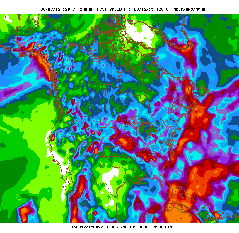
That is amazing! The latest CPC forecast (as of May 31st) shows a wet signal for the southern plains after the first week or so of June. Not sure if they need to revise or not.

Image
An extremely active pattern, partly associated with El Niño related climate anomalies, continued across the central and south-central U.S., promoting widespread heavy rainfall. These rains continued to erase drought conditions that have persisted for 3 years, but also led to devastating and deadly flooding across parts of Texas and Oklahoma. Currently, only small areas of long term (multi-year) D1 remain across the Plains. Significant rainfall also fell across the upper Midwest, promoting drought reduction across Minnesota and Wisconsin. Additional widespread rainfall fell across the south-central U.S. following the latest Drought Monitor period, exacerbating flooding and adding to massive runoff that is currently filling reservoirs. These rains may further reduce the remaining drought areas across the central and southern Plains. During the next several days, drier weather is forecast across much of Kansas and Oklahoma, but widespread rainfall is anticipated to return to much of Texas, the northern Plains, and the upper Midwest. Both the CPC 8-14 day outlook and the revised monthly outlook maintain a wet signal across most of the Plains and Midwest. Based on current conditions and these outlooks, continued drought reduction is expected, and the Plains may be largely drought-free during much of June.
Forecast confidence for the Plains and upper-Midwest is high
.
0 likes   
The preceding post is NOT an official forecast, and should not be used as such. It is only the opinion of the poster and may or may not be backed by sound meteorological data. It is NOT endorsed by any professional institution including storm2k.org. For Official Information please refer to the NHC and NWS products.

weatherdude1108
Category 5
Category 5
Posts: 4228
Joined: Tue Dec 13, 2011 1:04 pm
Location: Northwest Austin/Cedar Park, TX

#2037 Postby weatherdude1108 » Thu Jun 04, 2015 3:11 pm

White donut hole over most of Texas on yesterday's map has started to fill in today with greens, blues, and a purple or two (today's map below).

Image
0 likes   
The preceding post is NOT an official forecast, and should not be used as such. It is only the opinion of the poster and may or may not be backed by sound meteorological data. It is NOT endorsed by any professional institution including storm2k.org. For Official Information please refer to the NHC and NWS products.

User avatar
Rgv20
S2K Supporter
S2K Supporter
Posts: 2466
Age: 38
Joined: Wed Jan 05, 2011 5:42 pm
Location: Edinburg/McAllen Tx

#2038 Postby Rgv20 » Thu Jun 04, 2015 9:21 pm

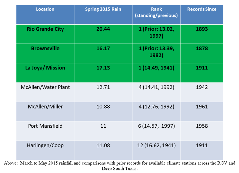
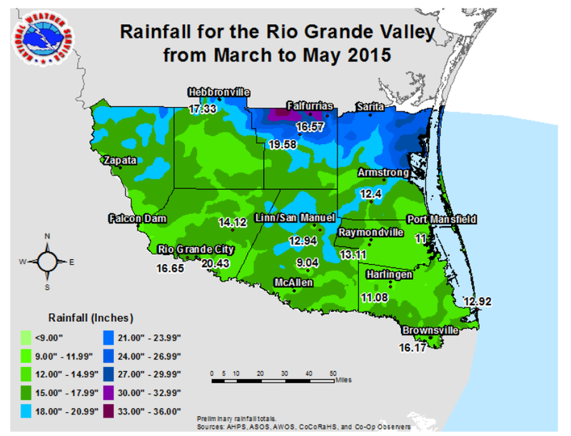
Below are the graphics for observed rainfall from March thru May.......:eek: My area just destroyed the old rainfall record! :eek:

Image

Image
0 likes   
The following post is NOT an official forecast and should not be used as such. It is just the opinion of the poster and may or may not be backed by sound meteorological data. It is NOT endorsed by any professional institution including storm2k.org For Official Information please refer to the NHC and NWS products.

User avatar
Ntxw
Storm2k Moderator
Storm2k Moderator
Posts: 22784
Joined: Wed Oct 21, 2009 6:34 pm
Location: DFW, Texas

#2039 Postby Ntxw » Thu Jun 04, 2015 11:21 pm

Tranquil weather continues but...

Changes are coming, don't have the stuff put together with other things going on tonight. I'll do a bigger post on Saturday or Sunday. The quiet weather will come to an end soon.
0 likes   
The above post and any post by Ntxw is NOT an official forecast and should not be used as such. It is just the opinion of the poster and may or may not be backed by sound meteorological data. It is NOT endorsed by any professional institution including Storm2k. For official information, please refer to NWS products.


  Help support Storm2K!

Help Support Storm2K


weatherdude1108
Category 5
Category 5
Posts: 4228
Joined: Tue Dec 13, 2011 1:04 pm
Location: Northwest Austin/Cedar Park, TX

#2040 Postby weatherdude1108 » Thu Jun 04, 2015 11:23 pm

Bob Rose:

I'm beginning to see some signs the weather pattern will turn a little more unsettled late next week into next weekend

Some changes in the weather pattern do look to take place beginning the middle of next week when the ridge of high pressure weakens and begins to shift southwest into Mexico. As the ridge weakens, the atmosphere looks to become less stable and this should allow for the development of widely scattered afternoon and evening rain showers and thunderstorms next Wednesday and Thursday. Expect high temperatures to be around 88-90 degrees.

Long-range solutions call for a trough of low pressure to develop across the Plains states late next week, allowing a weak cold front to sink south into Texas. At the same time, moisture is forecast to spread north off the Gulf of Mexico. Both of these features look to cause an increasing chance for scattered rain showers and thunderstorms across Central and South Texas late next week into next weekend.

One item to watch for late next week is the possible development of tropical cyclone in the southwestern Gulf of Mexico. Some forecast solutions are showing this possibility and this idea is certainly not out of the question based on developments in the upper atmosphere and increasing moisture off the deep tropics. It's too early to say much more about this. Stay tuned for updates over the next few days.


Bob


http://www.lcra.org/water/river-and-wea ... ather.aspx
0 likes   
The preceding post is NOT an official forecast, and should not be used as such. It is only the opinion of the poster and may or may not be backed by sound meteorological data. It is NOT endorsed by any professional institution including storm2k.org. For Official Information please refer to the NHC and NWS products.


Return to “USA & Caribbean Weather”

Who is online

Users browsing this forum: cstrunk, snownado and 20 guests