The blizzard up north is something else
Can't wait til its our turn
Texas Fall 2018
Moderator: S2k Moderators
Forum rules

The posts in this forum are NOT official forecast and should not be used as such. They are just the opinion of the poster and may or may not be backed by sound meteorological data. They are NOT endorsed by any professional institution or STORM2K.
-
Haris

- Category 5

- Posts: 1814
- Joined: Mon Nov 27, 2017 8:19 pm
- Location: ( Bee Cave) West Austin, Texas
Re: Texas Fall 2018
It's very painful as weird as it sounds watching and missing such a beautiful perfect snowstorm over the plains. Very painful 
2 likes
Weather geek and a storm spotter in West Austin. Not a degreed meteorologist. Big snow fan. Love rain and cold! Despise heat!
-
Brent
- S2K Supporter

- Posts: 38737
- Age: 37
- Joined: Sun May 16, 2004 10:30 pm
- Location: Tulsa Oklahoma
- Contact:
Re: Texas Fall 2018
Haris wrote:It's very painful as weird as it sounds watching and missing such a beautiful perfect snowstorm over the plains. Very painful
Missed a blizzard in Chicago by 6 weeks!

0 likes
#neversummer


Re: Texas Fall 2018
Brent wrote:The blizzard up north is something else
Can't wait til its our turn
Blizzard on the GFS. Path TBD.
Still thinking Dec 1-5 is period to watch.
2 likes
The above post and any post by Ntxw is NOT an official forecast and should not be used as such. It is just the opinion of the poster and may or may not be backed by sound meteorological data. It is NOT endorsed by any professional institution including Storm2k. For official information, please refer to NWS products.
Help support Storm2K!
-
South Texas Storms

- Professional-Met

- Posts: 4256
- Joined: Thu Jun 24, 2010 12:28 am
- Location: Houston, TX
Re: Texas Fall 2018
18z GFS is close to having a decent snow storm across TX around December 6.
1 likes

-
bubba hotep

- S2K Supporter
- Posts: 6014
- Joined: Wed Dec 28, 2016 1:00 am
- Location: Collin County Texas
Re: Texas Fall 2018
12z FV3 bringing the mother load of cold air?

2 likes
Winter time post are almost exclusively focused on the DFW area.
-
northjaxpro

- S2K Supporter
- Posts: 8900
- Joined: Mon Sep 27, 2010 11:21 am
- Location: Jacksonville, FL
Re: Texas Fall 2018
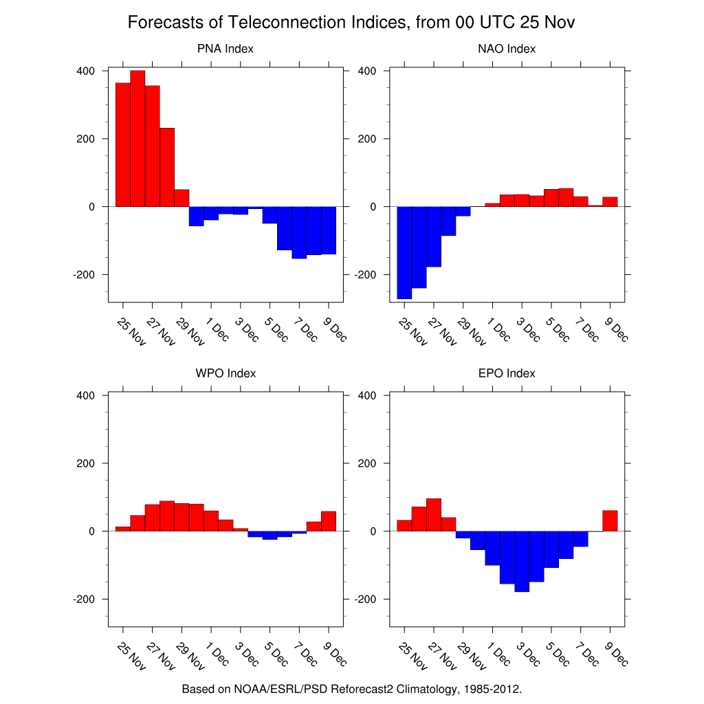
Cpv17 wrote:This +PNA has got to go!
Yeah, long range models hinting height rises at mid to upper levels across the Intermountain West and Western Canada in the next 10 days. We will see if indeed we are seeing a period of +PNA.
GFS long range is also showing deep upper trough potentially across the Eastern CONUS by the end of the first week of December. As I mentioned on a post previous page, GFS in long range showing a potent Arctic High coming down out of Saskatchewan south into the lower CONUS during the first week of December.
2 likes
NEVER, EVER SAY NEVER in the tropics and weather in general, and most importantly, with life itself!!
________________________________________________________________________________________
Fay 2008 Beryl 2012 Debby 2012 Colin 2016 Hermine 2016 Julia 2016 Matthew 2016 Irma 2017 Dorian 2019
________________________________________________________________________________________
Fay 2008 Beryl 2012 Debby 2012 Colin 2016 Hermine 2016 Julia 2016 Matthew 2016 Irma 2017 Dorian 2019
-
Brent
- S2K Supporter
- Posts: 38737
- Age: 37
- Joined: Sun May 16, 2004 10:30 pm
- Location: Tulsa Oklahoma
- Contact:
Re: Texas Fall 2018
Cpv17 wrote:This +PNA has got to go!
Cant be gone soon enough
I really hope early December produces
2 likes
#neversummer
-
TeamPlayersBlue

- Category 5
- Posts: 3530
- Joined: Tue Feb 02, 2010 1:44 am
- Location: Denver/Applewood, CO
Re: Texas Fall 2018
Lotta football left guys. Im ok with things being fairly zonal at the moment. Let that snow pack continue to grow in Canada. One thing i noticed about the 1977 winter thats similar to this one the snow pack was enormous all the way down into the plains. Storms like the one today dumping big snows that can stick around are good for us. Doesnt modify the HP as much when they descend into Texas
1 likes
Personal Forecast Disclaimer:
The posts in this forum are NOT official forecast and should not be used as such. They are just the opinion of the poster and may or may not be backed by sound meteorological data. They are NOT endorsed by any professional institution or storm2k.org. For official information, please refer to the NHC and NWS products.
The posts in this forum are NOT official forecast and should not be used as such. They are just the opinion of the poster and may or may not be backed by sound meteorological data. They are NOT endorsed by any professional institution or storm2k.org. For official information, please refer to the NHC and NWS products.
-
CaptinCrunch

- S2K Supporter
- Posts: 8779
- Age: 58
- Joined: Mon Nov 03, 2003 4:33 pm
- Location: Kennedale, TX (Tarrant Co.)
Re: Texas Fall 2018
NWS FTW
LONG TERM... /Issued 311 PM CST Sun Nov 25 2018/
/Monday through Sunday/
After a cold start to the morning with temperatures at sunrise in
the upper 20s to the mid 30s, a steady warmup is expected Monday under full sun. Afternoon temperatures will still be below normal with highs mainly in the lower and middle 50s.
Dry northwest flow aloft will continue Monday night and Tuesday with ridging over the western half of the country and a deep trough in the east. This pattern will keep North and Central Texas mostly clear and dry, allowing for optimal radiational cooling Monday night, with lows near or below freezing in most locations. Tuesday will be slightly warmer but still below seasonal normals with highs in upper 50s and lower 60s.
The upper pattern will become more zonal Tuesday night/Wednesday as the upper ridge axis shifts to the Plains and an upper trough strengthens off the West Coast. The surface reflection from this upper pattern will be lee troughing across the Central and Southern High Plains with increasing low level warm/moist advection across North and Central Texas. Therefore, it will be warmer Tuesday night/Wednesday with lows from the mid 30s to lower 40s and highs in the 60s.
The upper trough will deepen as it move into the western CONUS Thursday, further intensifying the surface lee trough and
bringing a good return of low level moisture to the region along
with a few warm air advection sprinkles. The better precipitation
chances will arrive Friday when the upper system moves across the Four Corners region, increasing large scale lift and
destabilizing the atmosphere over Texas. There are still some
model differences regarding the strength and speed of the upper low, but overall it appears that the best chance for showers and thunderstorms will be Friday night/early Saturday. The upper low is progged to lift northeast into the Central Plains Saturda night while dry air moves in behind a cold front.
Another upper trough is forecast by the GFS to move into the
Great Basin and Central Rockies on Sunday. If this solution
verifies it will bring a quick return of Gulf moisture to
North/Central Texas Sunday with rain/thunderstorm chances Sunday night/Monday. The ECMWF solution on the other hand keeps the forecast dry Sunday through Monday with zonal flow over much of the CONUS. We will side with the drier ECMWF solution for now and await some model consensus before introducing any PoPs for the first week of December.
0 likes
-
ThunderSleetDreams

- S2K Supporter
- Posts: 1510
- Age: 43
- Joined: Tue Dec 20, 2011 4:42 pm
- Location: S of Weimar, TX
Re: Texas Fall 2018
Whew, I think I’m still drunk from the LSU-A&M game... now bring me FRIGID AIR and moisture.
8 likes
#NeverSummer
I hibernate when it gets above 75 degrees!
I hibernate when it gets above 75 degrees!
Re: Texas Fall 2018
You know, in any other year that we weren't looking for snow the news of the upcoming -EPO/-PNA dip would be newsworthy and buzz on the board about early season unusual cold. The PNA dip is what will allow the storms to dig into the west before coming out. Of course snow has made a lot of headlines for this winter so that's been on the back burner. Chilly start to December.
4 likes
The above post and any post by Ntxw is NOT an official forecast and should not be used as such. It is just the opinion of the poster and may or may not be backed by sound meteorological data. It is NOT endorsed by any professional institution including Storm2k. For official information, please refer to NWS products.
Help support Storm2K!
Help support Storm2K!
-
hamburgerman7070
- Category 1

- Posts: 253
- Joined: Sat Dec 02, 2017 7:39 pm
- Location: Jonesboro ar
Re: Texas Fall 2018
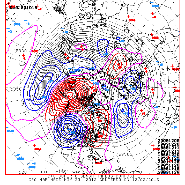
Ntxw wrote:You know, in any other year that we weren't looking for snow the news of the upcoming -EPO/-PNA dip would be newsworthy and buzz on the board about early season unusual cold. The PNA dip is what will allow the storms to dig into the west before coming out. Of course snow has made a lot of headlines for this winter so that's been on the back burner. Chilly start to December.
https://images2.imgbox.com/68/69/Tv3snyXE_o.jpg
Ntxw, to me, if the ensembles are correct in the epo and pna, the euro should start to show more storminess instead of dry scenarios
3 likes
Re: Texas Fall 2018
hamburgerman7070 wrote:Ntxw wrote:You know, in any other year that we weren't looking for snow the news of the upcoming -EPO/-PNA dip would be newsworthy and buzz on the board about early season unusual cold. The PNA dip is what will allow the storms to dig into the west before coming out. Of course snow has made a lot of headlines for this winter so that's been on the back burner. Chilly start to December.
https://images2.imgbox.com/68/69/Tv3snyXE_o.jpg
Ntxw, to me, if the ensembles are correct in the epo and pna, the euro should start to show more storminess instead of dry scenarios
I agree. I am not set on looking at the surface maps yet. You got to watch the 500mb shortwaves first. If they dig enough west of us there will be moisture. If they don't dig then it (moisture) will be north of us. A lot of lift in such a broad trough.
If the initial shortwave slows down and kicks out later, it's not going to be an Okla/KS snowstorm but rather west Texas/N Texas storm.
3 likes
The above post and any post by Ntxw is NOT an official forecast and should not be used as such. It is just the opinion of the poster and may or may not be backed by sound meteorological data. It is NOT endorsed by any professional institution including Storm2k. For official information, please refer to NWS products.
Help support Storm2K!
Help support Storm2K!
Re: Texas Fall 2018
Top heavy for D8 
7 likes
The above post and any post by Ntxw is NOT an official forecast and should not be used as such. It is just the opinion of the poster and may or may not be backed by sound meteorological data. It is NOT endorsed by any professional institution including Storm2k. For official information, please refer to NWS products.
Help support Storm2K!
Help support Storm2K!
-
Brent
- S2K Supporter
- Posts: 38737
- Age: 37
- Joined: Sun May 16, 2004 10:30 pm
- Location: Tulsa Oklahoma
- Contact:
Re: Texas Fall 2018
Euro looking interesting around December 4th, some light snow along an arctic front NW of DFW and so close to being something bigger. One thing for sure, that is looking like the next shot at some really cold air like a couple weeks ago. Hopefully with moisture this time
until then the +PNA Is killing us, most of Friday's rain is east
until then the +PNA Is killing us, most of Friday's rain is east
2 likes
#neversummer
-
Ralph's Weather
- S2K Supporter
- Posts: 3371
- Age: 38
- Joined: Fri Dec 13, 2013 11:55 am
- Location: Lindale, TX
- Contact:
Re: Texas Fall 2018
Models are getting closer to something good during the time period we have been highlighting. Now just need the trough to dig into Baja vs CA/NV to direct the moisture to the I-20 vs I-70 corridor. It is approaching the time where op runs can be useful, but I'd wait until late this week before concerning yourself too much with surface depictions for anything but entertainment.
0 likes
Follow on Facebook at Ralph's Weather.
-
Ralph's Weather
- S2K Supporter
- Posts: 3371
- Age: 38
- Joined: Fri Dec 13, 2013 11:55 am
- Location: Lindale, TX
- Contact:
Re: Texas Fall 2018
Watch how far south the system late this week digs. Models show it digging top the 4 Corners and heading due east. If it can dig south of I-40 I think our winter storm chances next week increase as each trough in this series should dig further south. At surface of the heavy snow late this week is along I-40 then we are looking good for next week to be along I-20. Also remember that there will be a final piece late next week before the +PNA returns so we will begin watching that also.
0 likes
Follow on Facebook at Ralph's Weather.
-
Yukon Cornelius
- S2K Supporter
- Posts: 1842
- Age: 42
- Joined: Thu Dec 20, 2012 9:23 pm
- Location: Dean, TX/Westcliffe, CO
Re: Texas Fall 2018
Nice to have another cold morning. Made it down to 27 with a heavy frost.
1 likes
#neversummer
Return to “USA & Caribbean Weather”
Who is online
Users browsing this forum: HurricaneBelle and 72 guests