Florida Weather
Moderator: S2k Moderators
Forum rules

The posts in this forum are NOT official forecast and should not be used as such. They are just the opinion of the poster and may or may not be backed by sound meteorological data. They are NOT endorsed by any professional institution or STORM2K.
-
HURAKAN

- Professional-Met

- Posts: 46084
- Age: 39
- Joined: Thu May 20, 2004 4:34 pm
- Location: Key West, FL
- Contact:
Miami: 3.04 inches
Based on the records of the NWS Miami office, the last time that more than 3 inches of rain were received in one day was May 15, 2006. Just over 4 inches of rain were accumulated that day.
Link: http://www.weather.gov/climate/getclima ... %3A11%3A11
Based on the records of the NWS Miami office, the last time that more than 3 inches of rain were received in one day was May 15, 2006. Just over 4 inches of rain were accumulated that day.
Link: http://www.weather.gov/climate/getclima ... %3A11%3A11
0 likes

-
tropicana

- Category 5

- Posts: 8056
- Joined: Sat Sep 27, 2003 6:48 pm
- Location: Niagara Falls, Ontario, Canada
- Contact:
Re:
HURAKAN wrote:Miami: 3.04 inches
Based on the records of the NWS Miami office, the last time that more than 3 inches of rain were received in one day was May 15, 2006. Just over 4 inches of rain were accumulated that day.
Link: http://www.weather.gov/climate/getclima ... %3A11%3A11
Yea, you beat me to that fact. It is a shame with all the rain though, the record of 1995 still stands grrrrr i hate when that happens.
0 likes


Re: Florida Weather Thread-Strong storms possible today
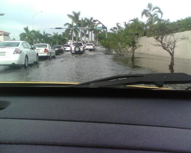
The only problem with that much rain coming down so fast it the run off. Much better to get that much rain during several hours so it has a chance to sink into the earth. 
0 likes
SPECIAL WEATHER STATEMENT
NATIONAL WEATHER SERVICE MELBOURNE FL
554 PM EDT FRI JUN 20 2008
FLZ045-053-202245-
ORANGE-OSCEOLA-
554 PM EDT FRI JUN 20 2008
...STRONG THUNDERSTORM AFFECTING NORTHEASTERN OSCEOLA COUNTY...MAY
ENTER RURAL SOUTHEAST ORANGE COUNTY...
AT 547 PM EDT...NATIONAL WEATHER SERVICE DOPPLER RADAR INDICATED A
STRONG STORM OVER HARMONY...MOVING NORTHEAST AT 10 MPH TOWARD NOVA
ROAD.
THE PRIMARY THREAT WILL BE CLOUD TO GROUND LIGHTNING STRIKES AND
GUSTY WINDS OF 45 TO 55 MPH...WHICH CAN CAUSE UNSECURED OBJECTS TO
BLOW AROUND...SNAP TREE LIMBS OR CAUSE POWER OUTAGES. HEAVY RAINFALL
WILL TEMPORARILY REDUCE VISIBILITY. SEEK SHELTER INDOORS UNTIL THE
STORM PASSES.
A BRIEF PERIOD OF SMALL HAIL...PEA TO DIME SIZE...WILL ALSO BE
POSSIBLE IN LOCALIZED AREAS.
TORRENTIAL RAINFALL CAN BE EXPECTED...CAUSING TEMPORARY PONDING ON
SOME ROADS AND MINOR FLOODING OF POOR DRAINAGE AREAS. MOTORISTS
SHOULD SLOW DOWN IN HEAVY RAINFALL TO REDUCE THE RISK OF HYDROPLANING
AND LEAVE SAFE DISTANCE BETWEEN OTHER VEHICLES.
$$
KELLY
0 likes


-
JonathanBelles
- Professional-Met
- Posts: 11430
- Age: 35
- Joined: Sat Dec 24, 2005 9:00 pm
- Location: School: Florida State University (Tallahassee, FL) Home: St. Petersburg, Florida
- Contact:
Re: Florida Weather Thread-Strong storms possible today
I've had a slight change in thought in the last few hours. If you look out in the GOM there is a, dare I say, a blob. This is going to make for a rainy day tomorrow across Florida. NWS has popped up the POPs to 60% over most of the Bay area, but at least for now, Im not going to be so strightforward with it. I think POPs will be 50% tomorrow Orlando (or Hernando County) South, 60% West and South of Lake O. 40% north of Orlando. The moisture will reach SW FL in the next few hours to the early morning hours of tomorrow and spread NEwrd. Possible washout in isolated spots for tomorrow. Temperatures should be pretty close to normal.
0 likes
Well thats not bad fact as at least it should mean that June will not come in nearly as below average as May was in terms of precip, indeed where abouts is S.Florida in terms of the June average right now?
SPECIAL WEATHER STATEMENT
NATIONAL WEATHER SERVICE MELBOURNE FL
613 PM EDT FRI JUN 20 2008
FLZ041-141-202300-
COASTAL VOLUSIA COUNTY-INLAND VOLUSIA COUNTY-
613 PM EDT FRI JUN 20 2008
...STRONG THUNDERSTORMS AFFECTING VOLUSIA COUNTY...
AT 611 PM EDT...NATIONAL WEATHER SERVICE DOPPLER RADAR INDICATED A
STRONG STORM OVER LAKE WOODRUFF...MOVING NORTHEAST AT 15 MPH.
THE STORM WILL MOVE THROUGH GLENWOOD AND DE LEON SPRINGS.
THE PRIMARY THREAT WILL BE CLOUD TO GROUND LIGHTNING STRIKES AND
GUSTY WINDS OF 45 TO 50 MPH...WHICH MAY CAUSE UNSECURED OBJECTS TO
BLOW AROUND. HEAVY RAINFALL WILL TEMPORARILY REDUCE VISIBILITY. SEEK
SHELTER INDOORS UNTIL THE STORM PASSES.
A BRIEF PERIOD OF SMALL HAIL...PEA TO DIME SIZE...WILL ALSO BE
POSSIBLE IN LOCALIZED AREAS.
$$
52
0 likes

Re: Florida Weather Thread-Strong storms possible today
The storms have been sitting off the coast from me all morning. Only .05 so far.
Looks like the heaviest are staying to my south.
And, it looks like Palm Harbor is going to get nailed again!
Looks like the heaviest are staying to my south.
And, it looks like Palm Harbor is going to get nailed again!
0 likes
-
Tampa Bay Hurricane

- Category 5
- Posts: 5597
- Age: 38
- Joined: Fri Jul 22, 2005 7:54 pm
- Location: St. Petersburg, FL


-
JonathanBelles
- Professional-Met
- Posts: 11430
- Age: 35
- Joined: Sat Dec 24, 2005 9:00 pm
- Location: School: Florida State University (Tallahassee, FL) Home: St. Petersburg, Florida
- Contact:
-
JonathanBelles
- Professional-Met
- Posts: 11430
- Age: 35
- Joined: Sat Dec 24, 2005 9:00 pm
- Location: School: Florida State University (Tallahassee, FL) Home: St. Petersburg, Florida
- Contact:
Large SVR for Polk
SEVERE THUNDERSTORM WARNING
FLC105-211715-
/O.NEW.KTBW.SV.W.0049.080621T1635Z-080621T1715Z/
BULLETIN - EAS ACTIVATION REQUESTED
SEVERE THUNDERSTORM WARNING
NATIONAL WEATHER SERVICE TAMPA BAY AREA - RUSKIN FL
1235 PM EDT SAT JUN 21 2008
THE NATIONAL WEATHER SERVICE IN RUSKIN HAS ISSUED A
* SEVERE THUNDERSTORM WARNING FOR...
CENTRAL POLK COUNTY IN FLORIDA.
* UNTIL 115 PM EDT
* AT 1235 PM EDT...NATIONAL WEATHER SERVICE DOPPLER RADAR INDICATED A
LINE OF SEVERE THUNDERSTORMS...CAPABLE OF PRODUCING PENNY SIZE HAIL
AND DAMAGING 60 MPH WINDS...FROM 7 MILES WEST OF BARTOW TO 10 MILES
SOUTH OF BARTOW...MOVING EAST AT 29 MPH.
* SEVERE THUNDERSTORMS WILL BE NEAR...
FORT MEADE.
BARTOW.
AUBURNDALE.
WAHNETA.
CYPRESS GARDENS.
HAINES CITY.
SEVERE THUNDERSTORMS CONTAIN WIND GUSTS OF 60 MPH OR HIGHER...AND
HAIL THE SIZE OF PENNIES OR LARGER. MOVE TO A PLACE OF SAFETY.
PLEASE REPORT TORNADOES OR FUNNEL CLOUDS...WINDS OF 58 MPH OR
HIGHER...HAIL THE SIZE OF PENNIES OR LARGER...AND ANY WIND DAMAGE TO
YOUR NATIONAL WEATHER SERVICE IN RUSKIN BY CALLING 813-645-2323.
&&
LAT...LON 2826 8175 2780 8135 2768 8180 2796 8206
TIME...MOT...LOC 1635Z 262DEG 26KT 2790 8189 2776 8176
$$
13
SEVERE THUNDERSTORM WARNING
FLC105-211715-
/O.NEW.KTBW.SV.W.0049.080621T1635Z-080621T1715Z/
BULLETIN - EAS ACTIVATION REQUESTED
SEVERE THUNDERSTORM WARNING
NATIONAL WEATHER SERVICE TAMPA BAY AREA - RUSKIN FL
1235 PM EDT SAT JUN 21 2008
THE NATIONAL WEATHER SERVICE IN RUSKIN HAS ISSUED A
* SEVERE THUNDERSTORM WARNING FOR...
CENTRAL POLK COUNTY IN FLORIDA.
* UNTIL 115 PM EDT
* AT 1235 PM EDT...NATIONAL WEATHER SERVICE DOPPLER RADAR INDICATED A
LINE OF SEVERE THUNDERSTORMS...CAPABLE OF PRODUCING PENNY SIZE HAIL
AND DAMAGING 60 MPH WINDS...FROM 7 MILES WEST OF BARTOW TO 10 MILES
SOUTH OF BARTOW...MOVING EAST AT 29 MPH.
* SEVERE THUNDERSTORMS WILL BE NEAR...
FORT MEADE.
BARTOW.
AUBURNDALE.
WAHNETA.
CYPRESS GARDENS.
HAINES CITY.
SEVERE THUNDERSTORMS CONTAIN WIND GUSTS OF 60 MPH OR HIGHER...AND
HAIL THE SIZE OF PENNIES OR LARGER. MOVE TO A PLACE OF SAFETY.
PLEASE REPORT TORNADOES OR FUNNEL CLOUDS...WINDS OF 58 MPH OR
HIGHER...HAIL THE SIZE OF PENNIES OR LARGER...AND ANY WIND DAMAGE TO
YOUR NATIONAL WEATHER SERVICE IN RUSKIN BY CALLING 813-645-2323.
&&
LAT...LON 2826 8175 2780 8135 2768 8180 2796 8206
TIME...MOT...LOC 1635Z 262DEG 26KT 2790 8189 2776 8176
$$
13
0 likes
-
JonathanBelles
- Professional-Met
- Posts: 11430
- Age: 35
- Joined: Sat Dec 24, 2005 9:00 pm
- Location: School: Florida State University (Tallahassee, FL) Home: St. Petersburg, Florida
- Contact:
there has been some training. I have received 2.4" so far. radar shows more rain headed the Caladesi/honeymoon region and points east and northeast. these areas have already been dumped on. normally such rains would cause at least some standing water but as soon as the rain intensity has let up the puddles disappear, illustrating how dry the soil is. it is just soaking it up.
0 likes
-
Extremeweatherguy

- Category 5
- Posts: 11095
- Joined: Mon Oct 10, 2005 8:13 pm
- Location: Florida
Return to “USA & Caribbean Weather”
Who is online
Users browsing this forum: cajungal, Iceresistance and 40 guests