Texas Summer 2016

U.S. & Caribbean Weather Discussions and Severe Weather Events

Moderator: S2k Moderators

Forum rules

The posts in this forum are NOT official forecast and should not be used as such. They are just the opinion of the poster and may or may not be backed by sound meteorological data. They are NOT endorsed by any professional institution or STORM2K.

Help Support Storm2K
Message
Author
User avatar
Ntxw
Storm2k Moderator
Storm2k Moderator
Posts: 22784
Joined: Wed Oct 21, 2009 6:34 pm
Location: DFW, Texas

Re: Texas Summer 2016

#281 Postby Ntxw » Mon Jul 18, 2016 12:04 pm

Tireman4 wrote:Yeah but you all will get a front before us..remember, the first front to clear out the humidity is September 25th...the first true front is second week of October...ughh


If we can get the lows into the 60s for runs, we'll call it a win!
0 likes   
The above post and any post by Ntxw is NOT an official forecast and should not be used as such. It is just the opinion of the poster and may or may not be backed by sound meteorological data. It is NOT endorsed by any professional institution including Storm2k. For official information, please refer to NWS products.

  Help support Storm2K!
Help Support Storm2K

User avatar
Tireman4
S2K Supporter
S2K Supporter
Posts: 5853
Age: 59
Joined: Fri Jun 30, 2006 1:08 pm
Location: Humble, Texas
Contact:

Re: Texas Summer 2016

#282 Postby Tireman4 » Mon Jul 18, 2016 12:43 pm

True enough on that one...:) My A race is October 29th...:)
0 likes   

User avatar
Ntxw
Storm2k Moderator
Storm2k Moderator
Posts: 22784
Joined: Wed Oct 21, 2009 6:34 pm
Location: DFW, Texas

Re: Texas Summer 2016

#283 Postby Ntxw » Mon Jul 18, 2016 4:11 pm

For the umpteenth day in a row the GFS and NWS keeps predicting 99-100F the day before only to end up in the mid 90s at DFW
0 likes   
The above post and any post by Ntxw is NOT an official forecast and should not be used as such. It is just the opinion of the poster and may or may not be backed by sound meteorological data. It is NOT endorsed by any professional institution including Storm2k. For official information, please refer to NWS products.


  Help support Storm2K!

Help Support Storm2K


aggiecutter
Category 5
Category 5
Posts: 1753
Joined: Thu Oct 14, 2004 9:22 pm
Location: Texarkana

Re: Texas Summer 2016

#284 Postby aggiecutter » Mon Jul 18, 2016 4:17 pm

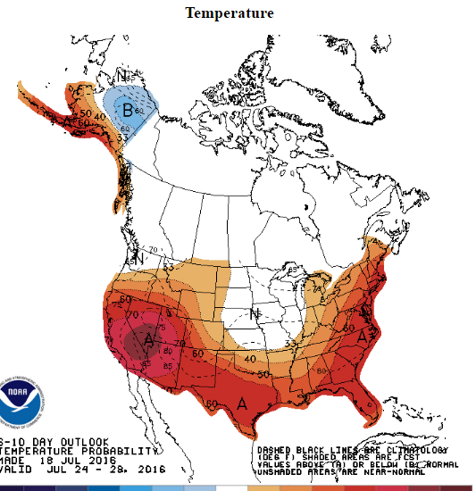
Relief on the way:

Image
0 likes   

User avatar
StormChaser75
Tropical Depression
Tropical Depression
Posts: 98
Age: 23
Joined: Sat Feb 06, 2016 4:23 pm
Location: Corpus Christi TX
Contact:

Re: Texas Summer 2016

#285 Postby StormChaser75 » Tue Jul 19, 2016 9:22 am

Just had a crazy summer storm with a tornado in it! Got video of the storm to. tornado was reported near oso bay!
0 likes   

User avatar
Ntxw
Storm2k Moderator
Storm2k Moderator
Posts: 22784
Joined: Wed Oct 21, 2009 6:34 pm
Location: DFW, Texas

Re: Texas Summer 2016

#286 Postby Ntxw » Tue Jul 19, 2016 11:48 am

It does look like the high pressure dome will weaken and move west after this week. Probably bringing back NW flow aloft and lesser temperatures. It's quite possible this is the apex of the summer heat dome and it's all downhill from here. The next week to week and a half is DFW's best chance at 100F. If we don't get it, you have to think about 1906 and 1973. Up north in the central and northern plains closer to the epicenter 100-105+! Whew good thing that is not us...
0 likes   
The above post and any post by Ntxw is NOT an official forecast and should not be used as such. It is just the opinion of the poster and may or may not be backed by sound meteorological data. It is NOT endorsed by any professional institution including Storm2k. For official information, please refer to NWS products.


  Help support Storm2K!

Help Support Storm2K


aggiecutter
Category 5
Category 5
Posts: 1753
Joined: Thu Oct 14, 2004 9:22 pm
Location: Texarkana

Re: Texas Summer 2016

#287 Postby aggiecutter » Tue Jul 19, 2016 6:37 pm

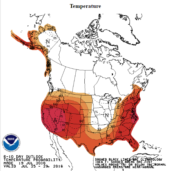
Get out the sweaters:

Image
1 likes   

User avatar
Tireman4
S2K Supporter
S2K Supporter
Posts: 5853
Age: 59
Joined: Fri Jun 30, 2006 1:08 pm
Location: Humble, Texas
Contact:

Re: Texas Summer 2016

#288 Postby Tireman4 » Wed Jul 20, 2016 10:04 am

000
FXUS64 KHGX 201121
AFDHGX

Area Forecast Discussion
National Weather Service Houston/Galveston TX
621 AM CDT WED JUL 20 2016

.AVIATION...
Locally dense fog near KLBX will burn off quickly with vsbys
improving by 13-14z. Still plenty of moisture over the western
Gulf and short term guidance suggests that moisture over the
southern half of the CWA is still sufficient to generate shra/tsra
by 16z once heating kicks in. Showers should diminish by 22-23z as
heating wanes. Clear skies expected overnight with patchy fog
possible near KLBX by sunrise. An upper level disturbance will
approach from the east in the aftn and this feature will trigger
sct aftn shra/tsra after 18z mainly east of I45. 43

&&

.PREV DISCUSSION... /ISSUED /

DISCUSSION...
Another warm and humid morning is underway for Southeast Texas
with 3 AM temperatures in the mid to upper 70s as the region
remains on the periphery of an expansive upper ridge over the
Southern Plains. Area radars show a few showers developing over
the coastal waters early this morning, with a few of these making
their way into coastal areas. Expect a fairly similar forecast to
yesterday with isolated to scattered marine convection persisting
through the remainder of the morning, with rain chances shifting
farther inland along the sea breeze late this morning and into
the afternoon. Greater subsidence from the upper ridge and
marginally lower moisture levels this afternoon (1.6-1.8 inch
PWATs) should provide for less shower and thunderstorm coverage
than yesterday. Otherwise, expect high temperatures again in the
low 90s along the coast and mid to upper 90s inland.

The upper ridge will maintain its influence over the region into
into the upcoming weekend, leaving a fairly stagnant pattern for
Southeast Texas. Warm and humid mornings with a few showers along
the coast will transition to hot and humid afternoons with a stray
shower or two generally along and south of the Highway 59
corridor. The NAM does attempt to bring a weak disturbance around
the upper ridge and across the region on Friday, and this may
result in higher PoPs (and lower temperatures) than what is
forecast. However, given the lack of consistency in this solution
with other models, will continue to trend closer to persistence
for this portion of the forecast. Otherwise, expect high
temperatures to gradually creep up into the upper 90s to possibly
100 at many inland locations on Thursday and Friday. Elevated heat
index values are expected through the end of the week but not
currently anticipating any heat advisories as forecast soundings
indicate enough mixing will occur to keep values in the 100-107
degree range.

A shortwave trough now off of the Washington/Oregon coasts early
this morning will gradually push towards the Rocky Mountains this
weekend, expanding the upper ridge across much of the southern
CONUS as it flattens. As heights aloft lower and subsidence over
the region weakens, a few more diurnally driven showers and
thunderstorms may be able to develop on Saturday and Sunday.
Temperatures will still remain hot in the upper 80s along the
coast to mid-upper 90s inland.

At the beginning of next week, a piece of energy looks to break
away from an upper trough located off the East Coast this morning,
retrograding westward under the broad flat ridge across the
southern CONUS. This weakness aloft reaching the region, combined
with low-mid level flow becoming more southeasterly (encouraging
more moisture to return to the region), looks to result in almost
daily chances for scattered showers and storms by the middle of
next week.

Huffman

MARINE...
High pressure over the SE U.S. and very weak low pressure over
the southwest Gulf will maintain light to moderate E-SE winds
through Friday morning. The high pressure will retreat east and
weak low pressure over the southern plains will induce more of a
southeast wind over the weekend. The pressure gradient will remain
weak and wind speeds are expected to remain below 15 knots through
the weekend. Tide levels will remain slightly elevated due to east
winds and levels will run about 1.0 to 1.25 feet above normal
through Friday. 43

&&

.PRELIMINARY POINT TEMPS/POPS...
College Station (CLL) 97 76 98 77 99 / 10 10 10 10 10
Houston (IAH) 96 77 97 77 97 / 20 10 20 10 20
Galveston (GLS) 91 81 92 82 90 / 30 20 20 10 10

&&

.HGX WATCHES/WARNINGS/ADVISORIES...
TX...NONE.
GM...NONE.
&&

$$

Discussion...14
Aviation/Marine...43
0 likes   

aggiecutter
Category 5
Category 5
Posts: 1753
Joined: Thu Oct 14, 2004 9:22 pm
Location: Texarkana

Re: Texas Summer 2016

#289 Postby aggiecutter » Wed Jul 20, 2016 4:22 pm

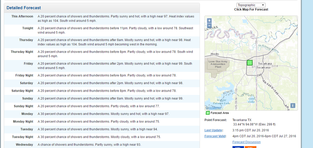
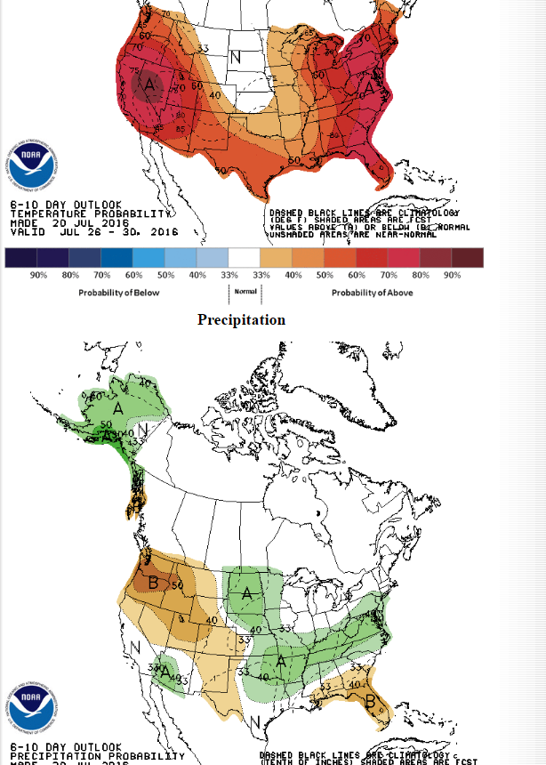
Rain and cooler temperatures on the way for NE Texas next week:

Image
0 likes   

aggiecutter
Category 5
Category 5
Posts: 1753
Joined: Thu Oct 14, 2004 9:22 pm
Location: Texarkana

Re: Texas Summer 2016

#290 Postby aggiecutter » Wed Jul 20, 2016 4:48 pm

3rd day in a row:

Image
0 likes   

User avatar
Tireman4
S2K Supporter
S2K Supporter
Posts: 5853
Age: 59
Joined: Fri Jun 30, 2006 1:08 pm
Location: Humble, Texas
Contact:

Re: Texas Summer 2016

#291 Postby Tireman4 » Thu Jul 21, 2016 8:37 am

000
FXUS64 KHGX 211052
AFDHGX

Area Forecast Discussion
National Weather Service Houston/Galveston TX
552 AM CDT THU JUL 21 2016

.AVIATION...
Some cirrus over the area this morning with some patchy fog near
KLBX. Expecting a cu field to develop between 15-17z with maybe a
few showers developing as temps warm into the mid 90s. Fcst
soundings show PW values AOA 2.00 inches this afternoon so can`t
rule out some scattered shra/tsra. HRRR/RAP continue to advertise
dry conditions across all TAF sites today. The gradient remains
weak and wind speeds should remain light and southeast today.
Generally VFR conds expected tonight with some patchy MVFR fog at
KLBX toward 12z. 43

&&

.PREV DISCUSSION... /ISSUED /

DISCUSSION...
Evening upper air analysis shows Southeast Texas remaining on the
southern periphery of a strong upper ridge centered over the
Southern Plains, with mid level heights nearly 600 decameters.
Precipitable water values across much of the region have fallen to
1.8 inches or less early this morning per SPC mesoanalysis, and
these lower moisture levels have resulted in a lack of convection
over the coastal waters. However, high resolution guidance
continues to advertise a few showers developing across the
offshore waters where greater moisture resides and have continued
low rain chances (20 PoPs) through the remainder of the morning.

For the rest of today, subsidence from the upper ridge will again
keep most of Southeast Texas dry. An isolated shower or
thunderstorm will again be possible along the sea breeze along the
coast (some may be capable of developing closer to the Interstate
10 corridor if an outflow boundary is produced from dying
convection), with greatest coverage southeast and east of the
Houston metro closer to better moisture over southwestern
Louisiana. If any convection does develop today, it will quickly
dissipate with sunset. Afternoon temperatures are expected to rise
into the mid to upper 90s inland, with low 90s along the coast. A
few sites across the Brazos Valley and Piney Woods regions
(including College Station) may even be able to reach 100. If
College Station reaches 100 today, it would be the first time it
has done so since August 15, 2015.

A warm start is expected again Friday morning with lows only
falling into the mid 70s to low 80s. The upper ridge appears to
nudge farther northwest of the region during the day on Friday and
there is fairly good model consensus for slightly higher PoPs on
Friday (as opposed to today) as a result. Have continued to
advertise 20-30 PoPs during the daytime hours with a somewhat more
active sea breeze. This shift may also allow for a few weak
disturbances rotating around the ridge to reach Southeast Texas on
Friday (further aiding in convective development). Interestingly,
tonight`s 00Z NAM continues the same trend it was showing 24 hours
ago, but with slightly slower timing (now in the late Friday-early
Saturday timeframe). Still have low confidence in this solution
given inconsistencies with other models and have kept the Friday
night forecast dry, but PoPs may need to be adjusted in this
timeframe for areas east of Interstate 45 should this feature
materialize.

A slow-moving shortwave trough remains off the Washington/Oregon
coasts early this morning per water vapor imagery and this
shortwave is forecast to slowly push east towards the Great Lakes
Friday through the weekend. As this happens, the upper ridge is
expected to flatten, expanding across the southern US and allowing
for a slight reduction in the influence of the ridge over
Southeast Texas as mid-level heights decrease. This will allow for
diurnally-driven scattered showers and thunderstorms to develop
this weekend and high temperatures a degree or two cooler (upper
80s coast to low-mid 90s inland) this weekend.

At the beginning of next week, the upper ridge begins to build
across the Great Basin as a secondary ridge develops over the
southeastern US. While medium range guidance disagrees on the
timing, persistent east/southeast mid-level flow will encourage
disturbances to retrograde under the upper ridge. While
temperatures are forecast to remain near seasonal normals, weak
lift associated with these disturbances will keep low daytime rain
chances in the forecast through the middle of next week.

Huffman

MARINE...
No significant changes to the forecast are expected through the
weekend for the marine areas as high pressure dominates the
weather pattern. High pressure over the eastern Gulf of Mexico and
low pressure over the central plains will produce generally light
to moderate E/SE winds across the area. A series of weak upper
level disturbances will bring scattered showers and thunderstorms
to the coastal waters Sunday through Wednesday. Tide levels will
remain slightly elevated through Friday. 43

&&

.PRELIMINARY POINT TEMPS/POPS...
College Station (CLL) 99 77 98 77 97 / 10 10 10 10 20
Houston (IAH) 97 78 97 77 96 / 10 10 30 10 30
Galveston (GLS) 92 82 91 82 90 / 20 10 20 20 20

&&

.HGX WATCHES/WARNINGS/ADVISORIES...
TX...NONE.
GM...NONE.
&&

$$

Discussion...14
Aviation/Marine...43
0 likes   

User avatar
Ntxw
Storm2k Moderator
Storm2k Moderator
Posts: 22784
Joined: Wed Oct 21, 2009 6:34 pm
Location: DFW, Texas

Re: Texas Summer 2016

#292 Postby Ntxw » Thu Jul 21, 2016 1:59 pm

Nail biters at DFW for 100 next couple of days. Will it stop at 99? If not, we may not get it the rest of the way.
0 likes   
The above post and any post by Ntxw is NOT an official forecast and should not be used as such. It is just the opinion of the poster and may or may not be backed by sound meteorological data. It is NOT endorsed by any professional institution including Storm2k. For official information, please refer to NWS products.


  Help support Storm2K!

Help Support Storm2K


User avatar
Tireman4
S2K Supporter
S2K Supporter
Posts: 5853
Age: 59
Joined: Fri Jun 30, 2006 1:08 pm
Location: Humble, Texas
Contact:

Re: Texas Summer 2016

#293 Postby Tireman4 » Thu Jul 21, 2016 2:31 pm

Ntxw wrote:Nail biters at DFW for 100 next couple of days. Will it stop at 99? If not, we may not get it the rest of the way.


You are discounting the dog days of August? ...:)
0 likes   

aggiecutter
Category 5
Category 5
Posts: 1753
Joined: Thu Oct 14, 2004 9:22 pm
Location: Texarkana

Re: Texas Summer 2016

#294 Postby aggiecutter » Thu Jul 21, 2016 2:57 pm

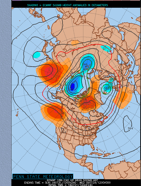
In the 8-10, the EURO moves the ridge out west, with a little weakness in the Central US:

Image
0 likes   

aggiecutter
Category 5
Category 5
Posts: 1753
Joined: Thu Oct 14, 2004 9:22 pm
Location: Texarkana

Re: Texas Summer 2016

#295 Postby aggiecutter » Thu Jul 21, 2016 3:08 pm

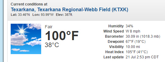
It happened:

Image
0 likes   

User avatar
Ntxw
Storm2k Moderator
Storm2k Moderator
Posts: 22784
Joined: Wed Oct 21, 2009 6:34 pm
Location: DFW, Texas

Re: Texas Summer 2016

#296 Postby Ntxw » Thu Jul 21, 2016 3:26 pm

Tireman4 wrote:
Ntxw wrote:Nail biters at DFW for 100 next couple of days. Will it stop at 99? If not, we may not get it the rest of the way.


You are discounting the dog days of August? ...:)


The pattern shift will allow slight cooling and small rain chances. Still seasonably hot for Aug. But nothing oppressive. I like the idea of real relief second half of August.
0 likes   
The above post and any post by Ntxw is NOT an official forecast and should not be used as such. It is just the opinion of the poster and may or may not be backed by sound meteorological data. It is NOT endorsed by any professional institution including Storm2k. For official information, please refer to NWS products.


  Help support Storm2K!

Help Support Storm2K


User avatar
srainhoutx
S2K Supporter
S2K Supporter
Posts: 6919
Age: 67
Joined: Sun Jan 14, 2007 11:34 am
Location: Haywood County, NC
Contact:

Re: Texas Summer 2016

#297 Postby srainhoutx » Thu Jul 21, 2016 4:12 pm

Hot and dry in a typical end of July fashion with isolated showers and storms mainly along the Coast and offshore will remain the sensible weather forecast the rest of today into tomorrow. A rather strong but not record breaking Heat Ridge develops across the Central/Northern Plains, Upper Mid West and the Atlantic Coast during the weekend, but we here along the Gulf Coast will be well South of the Upper Ridge and a Easterly wave currently across the Florida Straits and the NW Caribbean Sea arrives Saturday increasing PW's to above 2 inches suggesting increasing rain chances that will slowly spread inland as the Upper Ridge flattens out and we enter a typical Texas end of July weather Pattern.

Rain chances look to increase Sunday into early next week as a Tropical Upper Tropospheric Trough (TUTT)/low moves inland across Central America the Easterly tropical wave arrives in earnest with its higher moisture. Will need to monitor mid next week as a disturbance may round the Eastern flank of the Upper Ridge and head West beneath the underbelly of the Heat Dome as it meanders toward SE Texas and the Gulf Coastal waters.
0 likes   
Carla/Alicia/Jerry(In The Eye)/Michelle/Charley/Ivan/Dennis/Katrina/Rita/Wilma/Ike/Harvey

Member: National Weather Association
Wx Infinity Forums
http://wxinfinity.com/index.php

Facebook.com/WeatherInfinity
Twitter @WeatherInfinity

weatherdude1108
Category 5
Category 5
Posts: 4228
Joined: Tue Dec 13, 2011 1:04 pm
Location: Northwest Austin/Cedar Park, TX

Re: Texas Summer 2016

#298 Postby weatherdude1108 » Thu Jul 21, 2016 4:13 pm

Current conditions at
Austin City, Austin Camp Mabry (KATT)
Lat: 30.32°NLon: 97.77°WElev: 656ft.
Image
A Few Clouds
100°F
38°C
Humidity 34%
Wind Speed Vrbl 5 mph
Barometer 30.09 in (1017.3 mb)
Dewpoint 67°F (19°C)
Visibility 10.00 mi
Heat Index 105°F (41°C)
Last update 21 Jul 3:51 pm CDT
0 likes   
The preceding post is NOT an official forecast, and should not be used as such. It is only the opinion of the poster and may or may not be backed by sound meteorological data. It is NOT endorsed by any professional institution including storm2k.org. For Official Information please refer to the NHC and NWS products.

User avatar
Ntxw
Storm2k Moderator
Storm2k Moderator
Posts: 22784
Joined: Wed Oct 21, 2009 6:34 pm
Location: DFW, Texas

Re: Texas Summer 2016

#299 Postby Ntxw » Thu Jul 21, 2016 6:53 pm

DFW came up short at 99 today
0 likes   
The above post and any post by Ntxw is NOT an official forecast and should not be used as such. It is just the opinion of the poster and may or may not be backed by sound meteorological data. It is NOT endorsed by any professional institution including Storm2k. For official information, please refer to NWS products.


  Help support Storm2K!

Help Support Storm2K


User avatar
South Texas Storms
Professional-Met
Professional-Met
Posts: 4224
Joined: Thu Jun 24, 2010 12:28 am
Location: Houston, TX

Re: Texas Summer 2016

#300 Postby South Texas Storms » Thu Jul 21, 2016 7:59 pm

Ntxw wrote:DFW came up short at 99 today


Still several more shots at it over the next few days though. I bet yall reach it by Sunday.
0 likes   


Return to “USA & Caribbean Weather”

Who is online

Users browsing this forum: Brent, Brushcountry and 21 guests