February 5-6: Super Tuesday Outbreak... 57 dead
Moderator: S2k Moderators
Forum rules

The posts in this forum are NOT official forecast and should not be used as such. They are just the opinion of the poster and may or may not be backed by sound meteorological data. They are NOT endorsed by any professional institution or STORM2K.
-
JonathanBelles
- Professional-Met

- Posts: 11430
- Age: 35
- Joined: Sat Dec 24, 2005 9:00 pm
- Location: School: Florida State University (Tallahassee, FL) Home: St. Petersburg, Florida
- Contact:

-
Squarethecircle
- Category 5

- Posts: 2165
- Joined: Fri Oct 19, 2007 4:00 pm
- Location: Fairfax, VA
Re: Mardi Gras Outbreak - February 4-6
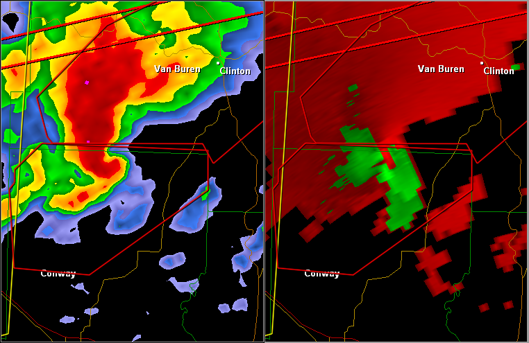
Conway Co
* AT 519 PM CST...NATIONAL WEATHER SERVICE DOPPLER RADAR INDICATED...
AND SPOTTERS HAVE CONFIRMED A TORNADO 18 MILES SOUTHWEST OF
CLINTON...OR 5 MILES SOUTHWEST OF SCOTLAND...MOVING NORTHEAST AT
50 MPH.
* AT 519 PM CST...NATIONAL WEATHER SERVICE DOPPLER RADAR INDICATED...
AND SPOTTERS HAVE CONFIRMED A TORNADO 18 MILES SOUTHWEST OF
CLINTON...OR 5 MILES SOUTHWEST OF SCOTLAND...MOVING NORTHEAST AT
50 MPH.
0 likes
-
CrazyC83
- Professional-Met
- Posts: 34315
- Joined: Tue Mar 07, 2006 11:57 pm
- Location: Deep South, for the first time!
WWUS54 KMEG 052326
SVSMEG
SEVERE WEATHER STATEMENT
NATIONAL WEATHER SERVICE MEMPHIS TN
525 PM CST TUE FEB 5 2008
MSC033-TNC047-157-060000-
/O.CON.KMEG.TO.W.0026.000000T0000Z-080206T0000Z/
DESOTO MS-FAYETTE TN-SHELBY TN-
525 PM CST TUE FEB 5 2008
...A TORNADO WARNING REMAINS IN EFFECT UNTIL 600 PM CST FOR SHELBY...
NORTHERN FAYETTE AND DESOTO COUNTIES...
...THIS IS A TORNADO EMERGENCY FOR THE WARNED AREA...
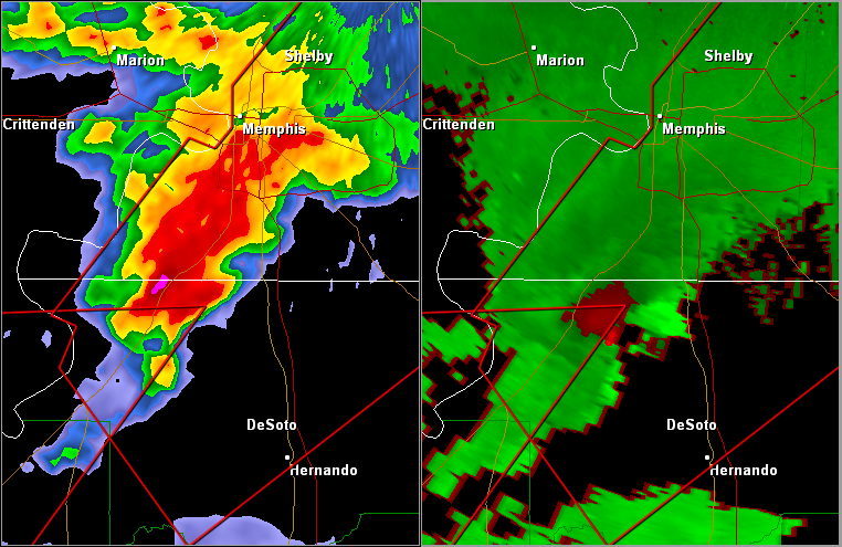
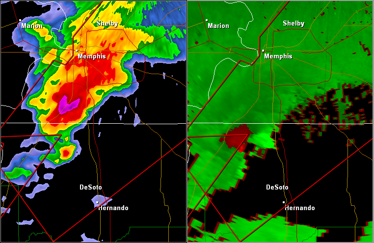
AT 525 PM CST...A TORNADO WAS REPORTED. THIS TORNADO WAS LOCATED
NEAR LYNCHBURG...OR ABOUT NEAR HORN LAKE...MOVING NORTHEAST AT 55
MPH.
OTHER LOCATIONS IN THE WARNING INCLUDE BUT ARE NOT LIMITED TO
SOUTHAVEN...WHITEHAVEN...SOUTHWEST MEMPHIS...DOWNTOWN MEMPHIS...OLIVE
BRANCH...MIDTOWN MEMPHIS...SOUTHEAST MEMPHIS...FRAYSER...
GERMANTOWN...COLLIERVILLE...BARTLETT...ELLENDALE...MILLINGTON...
LAKELAND...EADS...ARLINGTON...SOMERVILLE...OAKLAND AND GALLAWAY.
.IN ADDITION TO THE TORNADO...THIS STORM IS CAPABLE OF PRODUCING
GOLFBALL SIZE HAIL AND DESTRUCTIVE STRAIGHT LINE WINDS.
.THE SAFEST PLACE TO BE DURING A TORNADO IS IN A BASEMENT. GET UNDER
A WORKBENCH OR OTHER PIECE OF STURDY FURNITURE. IF NO BASEMENT IS
AVAILABLE...SEEK SHELTER ON THE LOWEST FLOOR OF THE BUILDING IN AN
INTERIOR HALLWAY OR ROOM SUCH AS A CLOSET. USE BLANKETS OR PILLOWS TO
COVER YOUR BODY AND ALWAYS STAY AWAY FROM WINDOWS.
.IF IN MOBILE HOMES OR VEHICLES...EVACUATE THEM AND GET INSIDE A
SUBSTANTIAL SHELTER. IF NO SHELTER IS AVAILABLE...LIE FLAT IN THE
NEAREST DITCH OR OTHER LOW SPOT AND COVER YOUR HEAD WITH YOUR HANDS.
.STAY TUNED TO THIS BROADCAST FOR THE LATEST UPDATES AND INFORMATION.
TO REPORT SEVERE WEATHER ONLY...CALL 1 800 4 3 2 0 8 7 5.
LAT...LON 3531 8921 3474 9011 3491 9026 3495 9024
3496 9027 3513 9011 3512 9008 3514 9006
3518 9006 3540 8984
TIME...MOT...LOC 2325Z 229DEG 48KT 3497 9007
$$
SVSMEG
SEVERE WEATHER STATEMENT
NATIONAL WEATHER SERVICE MEMPHIS TN
525 PM CST TUE FEB 5 2008
MSC033-TNC047-157-060000-
/O.CON.KMEG.TO.W.0026.000000T0000Z-080206T0000Z/
DESOTO MS-FAYETTE TN-SHELBY TN-
525 PM CST TUE FEB 5 2008
...A TORNADO WARNING REMAINS IN EFFECT UNTIL 600 PM CST FOR SHELBY...
NORTHERN FAYETTE AND DESOTO COUNTIES...
...THIS IS A TORNADO EMERGENCY FOR THE WARNED AREA...
AT 525 PM CST...A TORNADO WAS REPORTED. THIS TORNADO WAS LOCATED
NEAR LYNCHBURG...OR ABOUT NEAR HORN LAKE...MOVING NORTHEAST AT 55
MPH.
OTHER LOCATIONS IN THE WARNING INCLUDE BUT ARE NOT LIMITED TO
SOUTHAVEN...WHITEHAVEN...SOUTHWEST MEMPHIS...DOWNTOWN MEMPHIS...OLIVE
BRANCH...MIDTOWN MEMPHIS...SOUTHEAST MEMPHIS...FRAYSER...
GERMANTOWN...COLLIERVILLE...BARTLETT...ELLENDALE...MILLINGTON...
LAKELAND...EADS...ARLINGTON...SOMERVILLE...OAKLAND AND GALLAWAY.
.IN ADDITION TO THE TORNADO...THIS STORM IS CAPABLE OF PRODUCING
GOLFBALL SIZE HAIL AND DESTRUCTIVE STRAIGHT LINE WINDS.
.THE SAFEST PLACE TO BE DURING A TORNADO IS IN A BASEMENT. GET UNDER
A WORKBENCH OR OTHER PIECE OF STURDY FURNITURE. IF NO BASEMENT IS
AVAILABLE...SEEK SHELTER ON THE LOWEST FLOOR OF THE BUILDING IN AN
INTERIOR HALLWAY OR ROOM SUCH AS A CLOSET. USE BLANKETS OR PILLOWS TO
COVER YOUR BODY AND ALWAYS STAY AWAY FROM WINDOWS.
.IF IN MOBILE HOMES OR VEHICLES...EVACUATE THEM AND GET INSIDE A
SUBSTANTIAL SHELTER. IF NO SHELTER IS AVAILABLE...LIE FLAT IN THE
NEAREST DITCH OR OTHER LOW SPOT AND COVER YOUR HEAD WITH YOUR HANDS.
.STAY TUNED TO THIS BROADCAST FOR THE LATEST UPDATES AND INFORMATION.
TO REPORT SEVERE WEATHER ONLY...CALL 1 800 4 3 2 0 8 7 5.
LAT...LON 3531 8921 3474 9011 3491 9026 3495 9024
3496 9027 3513 9011 3512 9008 3514 9006
3518 9006 3540 8984
TIME...MOT...LOC 2325Z 229DEG 48KT 3497 9007
$$
0 likes
-
simplykristi
- S2K Supporter

- Posts: 1220
- Joined: Sat May 10, 2003 1:59 pm
- Location: Near KCMO
- Contact:
Re: Mardi Gras Outbreak - February 4-6
I am not surprised that there is a tornado emergency. The newsroom may have to clear out!
Kristi
Kristi
0 likes

Re: Mardi Gras Outbreak - February 4-6
Don't know if any of you guys track the Spotter Network, but I just had a report come across from one of the chasers in Conway County. Stated "Significant tornado with several homes badly damaged".
--snoopj
--snoopj
0 likes
-
simplykristi
- S2K Supporter
- Posts: 1220
- Joined: Sat May 10, 2003 1:59 pm
- Location: Near KCMO
- Contact:
-
Squarethecircle
- Category 5
- Posts: 2165
- Joined: Fri Oct 19, 2007 4:00 pm
- Location: Fairfax, VA
-
simplykristi
- S2K Supporter
- Posts: 1220
- Joined: Sat May 10, 2003 1:59 pm
- Location: Near KCMO
- Contact:

-
Squarethecircle
- Category 5
- Posts: 2165
- Joined: Fri Oct 19, 2007 4:00 pm
- Location: Fairfax, VA
-
simplykristi
- S2K Supporter
- Posts: 1220
- Joined: Sat May 10, 2003 1:59 pm
- Location: Near KCMO
- Contact:
Re:
Bunkertor wrote:http://www.wreg.com/global/video/popup/pop_player.asp?clipid1=mms://a771.l543940087.c5439.g.lm.akamaistream.net/D/771/5439/v0001/reflector:40087&at1=News&vt1=l&h1=Click+here+for+live+coverage%2E&d1=0&redirUrl=www.wreg.com&activePane=info&LaunchPageAdTag=homepage&playerVersion=9&hostPageUrl=http%3A//managewreg.worldnow.com/global/video/popup/pop_playerLaunch.asp%3Fclipid1%3Dmms%3A//a771.l543940087.c5439.g.lm.akamaistream.net/D/771/5439/v0001/reflector%3A40087%26at1%3DNews%26vt1%3Dl%26h1%3DClick+here+for+live+coverage%252E%26d1%3D0%26redirUrl%3Dwww.wreg.com%26activePane%3Dinfo%26LaunchPageAdTag%3Dhomepage&rnd=34582519
This is f&%$ing weird
What? I cannot get that feed to work.
Kristi
0 likes
Return to “USA & Caribbean Weather”
Who is online
Users browsing this forum: Iceresistance and 150 guests