Page 17 of 80

Re: Texas Fall 2022

Posted: Mon Oct 10, 2022 10:59 am
by bubba hotep
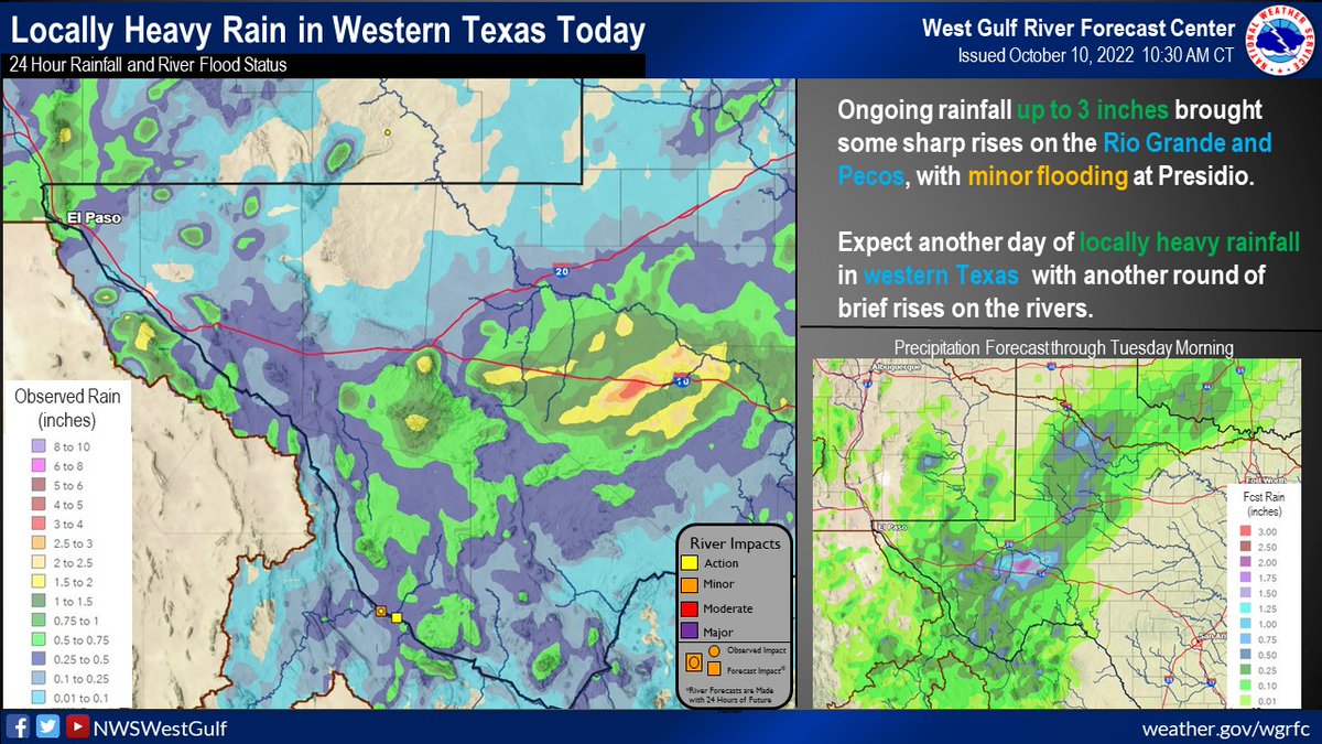
We will have to wait for rain here in N. TX but there are Flash Flood Watches out for SW Texas

Image

Re: Texas Fall 2022

Posted: Mon Oct 10, 2022 11:19 am
by Ntxw
Itryatgolf wrote:
Ntxw wrote:
bubba hotep wrote:
There are a number of things pointing to a -AO/NAO start to the winter. However, it seems like that is one of the trickier patterns to sniff out in the longer range. In the near term, it does look like a dip is coming with a legit below normal shot of cold air for N. TX. It looks to be a transient pattern with a pretty quick snap back to above normal. However, November has all the signs of a more persistent -AO/NAO patter but see the second sentence for my confidence level lol


I've come to terms that the Aleutian ridge is going to be a staple. I don't see a repeat of last Fall/Winter though. NPAC SSTs are too different. I do think we'll hear a lot more of the AO/NAO domain this winter like 2020.

Meanwhile agree with a good shot of cold air is probably coming, temperature wise October hasn't been too bad as it was looking beforehand.

Ntxw, I heard on twitter from a guy who posts there often that we are having persistent IO/MARITIME CONTINENT convection the reason the pna will remain positive. My question is, in winter, that is a very warm set up. Don't you think we want to see that convection shift before winter because phases4-6 are crazy warm phases for us


As we saw last winter you just need the low freq signal to shift slightly eastward, not even by much, to drastically change the downstream pattern. NPAC high over the Aleutians is a hot pattern, yet if it moves over to the GOA then you have a -EPO.

Re: Texas Fall 2022

Posted: Mon Oct 10, 2022 11:50 am
by Iceresistance
WPC has a nearly Statewide Rainfall event for Texas on Day 7!

Re: Texas Fall 2022

Posted: Mon Oct 10, 2022 11:58 am
by bubba hotep
Looks like my travel to NM will be one week too soon lol

Image

Re: Texas Fall 2022

Posted: Mon Oct 10, 2022 12:42 pm
by Iceresistance
End of 12z GFS tries to put out snow for the Oklahoma and Texas Panhandles, Lol.

Re: Texas Fall 2022

Posted: Mon Oct 10, 2022 2:21 pm
by Brent
A little bit of rain here but how about that GFS :spam:

Re: Texas Fall 2022

Posted: Mon Oct 10, 2022 2:58 pm
by gpsnowman
Brent wrote:A little bit of rain here but how about that GFS :spam:

Hello from Madrid Spain. Got a little shower here this morning and today was cool in the 60s. A couple more days here then 3 in Barcelona where temps should be in the low 70s. Perfect weather for walking around Spain. Hopefully we return to cooler and wetter weather.

Re: Texas Fall 2022

Posted: Mon Oct 10, 2022 5:58 pm
by Iceresistance
Got .2 inches today! Most in 35 days.

Re: Texas Fall 2022

Posted: Mon Oct 10, 2022 6:00 pm
by Cpv17
Iceresistance wrote:Got .2 inches today! Most in 35 days.


Well that will do absolutely nothing for your area as far as improving the drought but I guess it’s enough to settle some dust lol

Re: Texas Fall 2022

Posted: Mon Oct 10, 2022 6:34 pm
by Iceresistance
Cpv17 wrote:
Iceresistance wrote:Got .2 inches today! Most in 35 days.


Well that will do absolutely nothing for your area as far as improving the drought but I guess it’s enough to settle some dust lol


The ground is moist and the dirt roads are not kicking up much dust anymore when a car (or a school bus) drives on the road now that the rain has fallen. I still have more coming.

Re: Texas Fall 2022

Posted: Mon Oct 10, 2022 9:16 pm
by bubba hotep
Image


Mesoscale Precipitation Discussion 1082
NWS Weather Prediction Center College Park MD
921 PM EDT Mon Oct 10 2022

Areas affected...Portions of Western and Central TX

Concerning...Heavy rainfall...Flash flooding possible

Valid 110120Z - 110720Z

SUMMARY...Clusters of heavy showers and thunderstorms, with
locally some training of cells, may result in a few instances of
flash flooding heading into the overnight hours.

DISCUSSION...A broad mid-level trough ejecting east out into the
far southern High Plains will be interacting with a relatively
moist and modestly unstable airmass for a few clusters of heavy
showers and thunderstorms to continue impacting portions of
western and central TX heading into the overnight hours.

The latest RAP analysis shows MUCAPE values of as much as 1000 to
1500+ j/kg with PWs of around 1.1 to 1.3 inches. There is a fair
degree of upper-level divergence over the region just out ahead of
the upstream trough, and this forcing coupled with the available
thermodynamics has fostered some upscale growth of convection over
the last couple of hours around the Fort Stockton area, and also
for areas off to the northeast in between Big Spring and Abilene.

There is evidence of a surface trough across this region, and the
convection is focusing near this boundary with the aid of somewhat
stronger surface moisture convergence and proximity of a better
instability gradient. Over the next few hours, additional rounds
of showers and thunderstorms are expected, and there may be some
localized training of some of these convective cells as they
become aligned more southwest to northeast with the deeper layer
steering flow.

Convection may also begin to develop across some areas farther
down to the southwest closer to the Rio Grande River and adjacent
areas of TX Big Bend overnight as well, and the HRRR guidance
actually suggests convection initiating over northern Mexico may
spill over into the TX Big Bend.

Rainfall rates may reach 1 to 2 inches/hour with the stronger
cells, and some additional storm totals of 2 to 4 inches will be
possible where some of these cells train over the same area. A few
instances of flash flooding cannot be ruled out as a result
heading into the overnight hours.

Orrison

ATTN...WFO...MAF...SJT...

ATTN...RFC...WGRFC...NWC...

Re: Texas Fall 2022

Posted: Tue Oct 11, 2022 12:03 am
by Brent
It is coming down here right now. Definitely the best rain since the heavy event at the start of September

Also saw a TV forecast earlier with a HIGH of 59 next Monday :double:

Re: Texas Fall 2022

Posted: Tue Oct 11, 2022 8:14 am
by Iceresistance
Brent wrote:It is coming down here right now. Definitely the best rain since the heavy event at the start of September

Also saw a TV forecast earlier with a HIGH of 59 next Monday :double:


totaled .4 inches yesterday, the dust has been settled.

Re: Texas Fall 2022

Posted: Tue Oct 11, 2022 8:47 am
by Ralph's Weather
bubba hotep wrote:Looks like my travel to NM will be one week too soon lol

https://www.tropicaltidbits.com/analysis/models/gfs/2022101012/gfs_asnow_scus_35.png

The peaks have been getting some snow recently, but looks like the first big even is coming soon.

Re: Texas Fall 2022

Posted: Tue Oct 11, 2022 8:56 am
by Iceresistance
Surprised that no one mentioned the 0z GFS last night.

Image
https://s4.gifyu.com/images/0z-GFS.png

Re: Texas Fall 2022

Posted: Tue Oct 11, 2022 12:54 pm
by rwfromkansas
Crazy amount of hail in Fort Stockton last night. Some photos looked like a good 8 inches or more!

I taught there for a few years when I lived in Midland.

The high school where I worked was severely flooded.

Re: Texas Fall 2022

Posted: Tue Oct 11, 2022 1:40 pm
by TropicalTundra
End of CMC bringing a cold blast down the Central US by next Tuesday and Wednesday :eek: I think Ntxw mentioned this a few days earlier about an NAO block bringing some cold air to us.

Re: Texas Fall 2022

Posted: Tue Oct 11, 2022 1:53 pm
by Iceresistance
TropicalTundra wrote:End of CMC bringing a cold blast down the Central US by next Tuesday and Wednesday :eek: I think Ntxw mentioned this a few days earlier about an NAO block bringing some cold air to us.


KFOR has highs in the Mid-50s Next Tuesday!

The CMC also has a freeze as far south as San Antonio and Houston.

Re: Texas Fall 2022

Posted: Tue Oct 11, 2022 4:17 pm
by Brent
Yeah I've seen a couple TV mets here and OKC mention freezing temps possible

So far my coldest low here is around 40 but I am in the metro

Re: Texas Fall 2022

Posted: Tue Oct 11, 2022 4:36 pm
by Iceresistance
Brent wrote:Yeah I've seen a couple TV mets here and OKC mention freezing temps possible

So far my coldest low here is around 40 but I am in the metro


My coldest low is surprisingly 43°F