Nice little thunderstorm at the house (Near TC Jester S of FM 1960 (Spring). Thunder woke me up at 2 am, fell back asleep, cats don't like thunder, one was scratching at the door at 3 am. I get up at 5pm.
Models showed it dying before SETX, but it didn't. Local airports about 3/4 inch of rain.
Decent rain on all the globals and their ensemble between now and Friday night for STX near/E of I-35.
Texas Spring 2025
Moderator: S2k Moderators
Forum rules

The posts in this forum are NOT official forecast and should not be used as such. They are just the opinion of the poster and may or may not be backed by sound meteorological data. They are NOT endorsed by any professional institution or STORM2K.
-
TomballEd
- Category 5

- Posts: 1259
- Age: 62
- Joined: Wed Aug 16, 2023 4:52 pm
- Location: Spring/Klein area, not Tomball
Re: Texas Spring 2025
0 likes
-
Iceresistance

- Category 5
- Posts: 9577
- Age: 22
- Joined: Sat Oct 10, 2020 9:45 am
- Location: Tecumseh, OK/Norman, OK
Re: Texas Spring 2025
0 likes
Bill 2015 & Beta 2020
Winter 2020-2021
All observations are in Tecumseh, OK unless otherwise noted.
Winter posts are focused mainly for Oklahoma & Texas.
Take any of my forecasts with a grain of salt, refer to the NWS, SPC, and NHC for official information
Never say Never with weather! Because ANYTHING is possible!
Winter 2020-2021
All observations are in Tecumseh, OK unless otherwise noted.
Winter posts are focused mainly for Oklahoma & Texas.
Take any of my forecasts with a grain of salt, refer to the NWS, SPC, and NHC for official information
Never say Never with weather! Because ANYTHING is possible!

Re: Texas Spring 2025
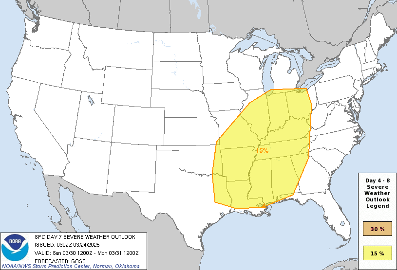
Iceresistance wrote:Been a while since I posted, but Day 7 is HUGE
https://s6.gifyu.com/images/bzgHW.gif
https://s6.gifyu.com/images/bzgHW.gif
Biggest day 7 risk ever issued. Covers 20 states.
0 likes
-
rwfromkansas
- Category 5
- Posts: 3016
- Joined: Sat Aug 27, 2005 12:47 am
- Location: North Fort Worth
-
wxman22

- Category 5
- Posts: 1877
- Joined: Mon Jan 30, 2006 12:39 am
- Location: Wichita Falls, TX
- Contact:
Re: Texas Spring 2025
I’m starting to feel more confident that a heavy rain event will be setting up this week in SC and SE Texas.I wouldn’t be surprised if some localized areas see 3-6 inches of rain from this.
1 likes
-
rwfromkansas
- Category 5
- Posts: 3016
- Joined: Sat Aug 27, 2005 12:47 am
- Location: North Fort Worth
Re: Texas Spring 2025
CFS showed TX severe weather this week, and it looks to be a fail so far.
All northeast TX on north and east.
All northeast TX on north and east.
0 likes
-
wxman22
- Category 5
- Posts: 1877
- Joined: Mon Jan 30, 2006 12:39 am
- Location: Wichita Falls, TX
- Contact:
Re: Texas Spring 2025
rwfromkansas wrote:CFS showed TX severe weather this week, and it looks to be a fail so far.
All northeast TX on north and east.
There was severe weather yesterday. Yesterday also was slightly under forecasted. The SPC could have gotten away with an Enhanced Risk for hail.

0 likes

Re: Texas Spring 2025
A marginal risk for severe weather has been issued today for DFW.
Highly conditional, but given the expected dewpoint depression, microbursts seem to be the main threat.
Highly conditional, but given the expected dewpoint depression, microbursts seem to be the main threat.
0 likes
-
rwfromkansas
- Category 5
- Posts: 3016
- Joined: Sat Aug 27, 2005 12:47 am
- Location: North Fort Worth
Re: Texas Spring 2025
wxman22 wrote:rwfromkansas wrote:CFS showed TX severe weather this week, and it looks to be a fail so far.
All northeast TX on north and east.
There was severe weather yesterday. Yesterday also was slightly under forecasted. The SPC could have gotten away with an Enhanced Risk for hail.
https://i.ibb.co/KcDmqZ0g/IMG-0318.png
True, that Kerrville hail was something terrifying.
0 likes
-
Yukon Cornelius
- S2K Supporter

- Posts: 1838
- Age: 42
- Joined: Thu Dec 20, 2012 9:23 pm
- Location: Dean, TX/Westcliffe, CO


Re: Texas Spring 2025
Seeing vertical cumulus just west and sw of here. Don’t think it’s rained for a while out this way.
1 likes
Re: Texas Spring 2025
DFW did officially make it to 90*F for the first time this year. Also, it's the hottest day of the year, thus far.
Not quite a record high though (that's 97*F).
DFW has another shot at hitting 90*F on Saturday.
Not quite a record high though (that's 97*F).
DFW has another shot at hitting 90*F on Saturday.
0 likes
-
TomballEd
- Category 5
- Posts: 1259
- Age: 62
- Joined: Wed Aug 16, 2023 4:52 pm
- Location: Spring/Klein area, not Tomball
Re: Texas Spring 2025
snownad[quote][/quote]o wrote:DFW did officially make it to 90*F for the first time this year. Also, it's the hottest day of the year, thus far.
Not quite a record high though (that's 97*F).
DFW has another shot at hitting 90*F on Saturday.
Houston did that March 13. Unusual for Houston to hit 90F first. I remember February 1996 it hit 99F in Austin, I was so bummed it didn't hit 100F. Feb. 21, 1996, holds the record as the hottest February day ever in Austin, with a high temperature of 99°. Three other February days had highs at or above 95°. ( https://www.kxan.com/weather/weather-blog/austins-weather-extremes-hottest-coldest-and-wettest-february-records/ )
In other news, somewhere near the Victoria Crossroads is going to get close to a foot of rain judging by the long range models.
EDIT TO ADD: CRP has pulled the pin on flood watches for the TX-44 corridor. I saw a John Wayne Western movie bar fight in Alice, TX (I pinned myself in a corner so nobody could attack with a beer bottle from behind) and have had breakfast in San Diego.
...FLOOD WATCH IN EFFECT FROM WEDNESDAY AFTERNOON THROUGH FRIDAY
MORNING...
* WHAT...Numerous flash floods likely with significant events
possible.
* WHERE...For all of South Texas
* WHEN...From Wednesday afternoon through Friday morning.
* IMPACTS...Excessive runoff may result in flooding of rivers,
creeks, streams, and other low-lying and flood-prone locations.
Creeks and streams may rise out of their banks. Flooding may occur
in poor drainage and urban areas. Low-water crossings may be
flooded.
* ADDITIONAL DETAILS...
- Abundant gulf moisture combined with a slow moving storm
system will bring the potential for multiple rounds of
showers and thunderstorms, some with very heavy rainfall. The
rain will begin Wednesday afternoon and continue through
Friday morning before ending. Given the hard dry soil from
the lack of rainfall over the past several months, there is a
potential for this heavy rain to quickly run off producing
flash flooding.
- http://www.weather.gov/safety/flood
0 likes

-
txtwister78

- Category 5
- Posts: 2159
- Joined: Wed Jan 30, 2019 12:56 pm
- Location: San Antonio
Re: Texas Spring 2025
Further south tomorrow into Thursday the main focus continues to centered on be where the bulk of the heaviest precip will establish itself as models today are still not in agreement. GFS,3km NAM, RAP and now the latest 18z Euro are more locked in on SA metro while HRRR, ICON and CMC indicate deep south Texas and along the coastal areas as the favored regions.
While moisture will be plentiful, as the NWS mentioned earlier in their AFD, these systems can be tricky with models as we all know coming out of the SW but I like some of the trends tonight and hopefully we can put a dent in this drought with some much needed rainfall over the next two days across areas that desperately need it.
While moisture will be plentiful, as the NWS mentioned earlier in their AFD, these systems can be tricky with models as we all know coming out of the SW but I like some of the trends tonight and hopefully we can put a dent in this drought with some much needed rainfall over the next two days across areas that desperately need it.
1 likes

Re: Texas Spring 2025
wxman22 wrote:Severe storms popping up in North Texas.
https://i.ibb.co/fYFBMbGb/Screenshot-2025-03-25-at-17-49-25-NWS-Radar.png
Pea sized hail here in North Dallas.
0 likes
Re: Texas Spring 2025
DallasAg wrote:wxman22 wrote:Severe storms popping up in North Texas.
https://i.ibb.co/fYFBMbGb/Screenshot-2025-03-25-at-17-49-25-NWS-Radar.png
Pea sized hail here in North Dallas.
We got the northern edge of that cell here in Plano, which went severe.
It was totally by surprise, as skies had mostly cleared out an hour ago and the radar wasn't loooking great.
But those were some humongous raindrops (we just missed the hail core) slamming against the roofs.
0 likes
Return to “USA & Caribbean Weather”
Who is online
Users browsing this forum: No registered users and 91 guests