Texas Summer 2016
Moderator: S2k Moderators
Forum rules

The posts in this forum are NOT official forecast and should not be used as such. They are just the opinion of the poster and may or may not be backed by sound meteorological data. They are NOT endorsed by any professional institution or STORM2K.
-
Ralph's Weather
- S2K Supporter

- Posts: 3371
- Age: 38
- Joined: Fri Dec 13, 2013 11:55 am
- Location: Lindale, TX
- Contact:
Re: Texas Summer 2016
Storms building in E TX. Hearing lots of thunder here in downtown Tyler, but the storms are staying just south of me for now.
0 likes
Follow on Facebook at Ralph's Weather.
-
aggiecutter
- Category 5

- Posts: 1755
- Joined: Thu Oct 14, 2004 9:22 pm
- Location: Texarkana
Re: Texas Summer 2016
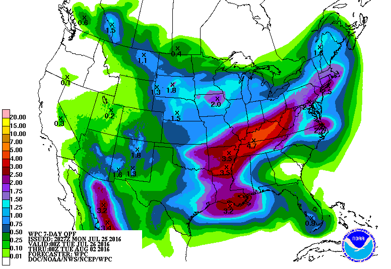
Lots of rain on the way for the Eastern Third of Texas the next 7 days:

0 likes
-
Brent
- S2K Supporter
- Posts: 38737
- Age: 37
- Joined: Sun May 16, 2004 10:30 pm
- Location: Tulsa Oklahoma
- Contact:
Re: Texas Summer 2016
Just had a nice thunderstorm here and looks like more coming in from the east 

0 likes
#neversummer
-
TeamPlayersBlue

- Category 5
- Posts: 3530
- Joined: Tue Feb 02, 2010 1:44 am
- Location: Denver/Applewood, CO
Re: Texas Summer 2016
Looked at the HRRR to see if these storms will continue to develop overnight and it shows an interesting spin off the coast of LA with the storms later tonight. Any chance of development out of this low?
0 likes
Personal Forecast Disclaimer:
The posts in this forum are NOT official forecast and should not be used as such. They are just the opinion of the poster and may or may not be backed by sound meteorological data. They are NOT endorsed by any professional institution or storm2k.org. For official information, please refer to the NHC and NWS products.
The posts in this forum are NOT official forecast and should not be used as such. They are just the opinion of the poster and may or may not be backed by sound meteorological data. They are NOT endorsed by any professional institution or storm2k.org. For official information, please refer to the NHC and NWS products.
-
weatherdude1108
- Category 5
- Posts: 4228
- Joined: Tue Dec 13, 2011 1:04 pm
- Location: Northwest Austin/Cedar Park, TX
Re: Texas Summer 2016
A solid moderate to heavy rain with thunder and lightning for 45 minutes. 0.77 in the gauge. Went from a high of 102 at our house today to 84 now. 
0 likes
The preceding post is NOT an official forecast, and should not be used as such. It is only the opinion of the poster and may or may not be backed by sound meteorological data. It is NOT endorsed by any professional institution including storm2k.org. For Official Information please refer to the NHC and NWS products.
-
TheAustinMan

- Category 5
- Posts: 1060
- Joined: Mon Jul 08, 2013 4:26 pm
- Location: Central TX / United States
Re: Texas Summer 2016
Reporting from Southwest Austin... the rain is coming down quite heavily with the occasional thunder, all after a nice introduction of 30-35 mph wind gusts from an outflow boundary moving through! A welcome change from the norm this summer, though everyone's recycle bins are outside and open! 
1 likes
Treat my opinions with a grain of salt. For official information see your local weather service.
“It's tough to make predictions, especially about the future.”
“It's tough to make predictions, especially about the future.”


Re: Texas Summer 2016
Got some rain today after only a little yesterday. Hoping for one more day of rain before the faucet starts to shut off. August is looking less like relief and more like July.
0 likes
Resident Rain Miser
I am a weather hobbyist living 3.5 miles south of Downtown Austin and in no way or fashion should anything I say concerning forecasts be taken seriously. Please check your local NWS for accurate weather forecasting and conditions.
I am a weather hobbyist living 3.5 miles south of Downtown Austin and in no way or fashion should anything I say concerning forecasts be taken seriously. Please check your local NWS for accurate weather forecasting and conditions.
-
1900hurricane

- Category 5
- Posts: 6063
- Age: 34
- Joined: Fri Feb 06, 2015 12:04 pm
- Location: Houston, TX
- Contact:
Re: Texas Summer 2016
First rain of the month! Don't know how much I picked up personally since my roommate ran over my rain gauge with the lawnmower a few weeks back, but Easterwood got .06".
0 likes
Contract Meteorologist. TAMU & MSST. Fiercely authentic, one of a kind. We are all given free will, so choose a life meant to be lived. We are the Masters of our own Stories.
Opinions expressed are mine alone.
Follow me on Twitter at @1900hurricane : Read blogs at https://1900hurricane.wordpress.com/
Opinions expressed are mine alone.
Follow me on Twitter at @1900hurricane : Read blogs at https://1900hurricane.wordpress.com/
-
Tireman4

- S2K Supporter
- Posts: 5903
- Age: 60
- Joined: Fri Jun 30, 2006 1:08 pm
- Location: Humble, Texas
- Contact:
Re: Texas Summer 2016
000
FXUS64 KHGX 271141
AFDHGX
Area Forecast Discussion
National Weather Service Houston/Galveston TX
641 AM CDT WED JUL 27 2016
.AVIATION...
KIAH/KHOU/KSGR/KLBX/KGLS...currently have VFR CIGS but could see a
brief period of MVFR this morning as SHRA/TSRA become organized
over the next couple of hours. Radar already showing showers and a
few storms forming along the coast. The 09z HRRR had a decent
handle on convective trends with showers and storms forming along
the coast and then spreading inland 14-20z. The latest 10z HRRR
has storms forming more over Houston by 16z so will need to watch
these trends. Activity may come to an end during the late
afternoon rather than later in the evening. Main threats from
storms beside lightning will be gusty winds. Overnight expect VFR
CIGS to continue with light winds. May still get some low stratus
to form in the morning and then possibly more convection for the
late morning hours Thursday.
KCLL/KUTS/KCXO...currently VFR CIGS but have had a mix of IFR/MVFR
CIGS as well at times. Trends in HRRR support convection
developing later in the morning with possibly TSRA in the early
afternoon. Will go with VCTS for now but could need TSRA depending
upon how convection develops. Storms should dissipate later in
the afternoon. VFR CIGS are expected overnight but with winds
decoupling and clear skies...could get some decent radiational
cooling. Fog could then develop Thursday morning and likely
restrict visibility.
Overpeck
&&
.PREV DISCUSSION... /ISSUED /
DISCUSSION...
A weak upper low was shearing out over Louisiana and far eastern
Texas early this morning. The best moisture axis evident on water
vapor and the RAP analysis was across the Louisiana coast west-
southwest into the Upper Texas coastal waters and across Matagorda
Bay. RAP PW/s were between 2.2 and 2.3 inches in these areas.
Drier air rotating around the upper low was evident with PW/s 2
inches along and north of a line from about College Station to
Livingston.
The model consensus for today is for the deeper area of moisture
to move inland and north. Best chances for rain and thunderstorms
will be along the coast this morning with the storms moving inland
over the northern counties this afternoon. With the PW/s still
near 2.3 inches, there is a chance for locally heavy rainfall with
the stronger storms later this morning especially for locations
along and south of the I-10 corridor. The cloud cover and rain
areas will again make for a difficult temperature forecast. Still,
the potential is there for many inland locations to reach into the
lower 90s this afternoon.
For the remainder of the week, drier air will work its way
overhead. Although the models keep a weakness in the upper ridge
over Southeast Texas, 500 mb heights actually rise over the
weekend and through the first half of next week. This combination
should result in daytime highs reaching into the lower and mid 90s
and for at least afternoon and early evening chances for showers
and thunderstorms.
40
MARINE...
Scattered showers and thunderstorms will be possible starting out
this morning over the upper Texas coast. Like the last couple of
days, thunderstorm activity should spread inland during the day.
Overall coverage of storms should be less today as moisture
decreases some and the upper level trough moves west. Winds this
morning are running about 15 knots from the south for much of the
Upper Texas Coast. Winds should decrease later today and tonight.
Light to moderate southerly winds should continue into the
weekend.
Seas will be lingering around 3 feet today but decrease some as
winds decrease for the end of the week. Tide levels will likely
remain near normal levels or maybe a half foot above normal.
39
&&
.PRELIMINARY POINT TEMPS/POPS...
College Station (CLL) 93 76 95 76 96 / 50 20 30 10 20
Houston (IAH) 93 77 95 77 95 / 50 20 40 10 30
Galveston (GLS) 89 83 92 83 91 / 60 20 20 10 20
&&
.HGX WATCHES/WARNINGS/ADVISORIES...
TX...NONE.
GM...NONE.
&&
$$
Discussion...40
Aviation/Marine...39
0 likes
-
weatherdude1108
- Category 5
- Posts: 4228
- Joined: Tue Dec 13, 2011 1:04 pm
- Location: Northwest Austin/Cedar Park, TX
Re: Texas Summer 2016
I was driving to work this morning, and saw rain in the distance. Streets were dry. As soon as I hit the line, BAM, it was like driving through a waterfall, streets flooding, etc.  Couldn't see 10 feet in front of me for several seconds. Cautious excitement!
Rain break for now. Been moist throughout the day. Hoping to get more before the blast furnace kicks in again.
Rain break for now. Been moist throughout the day. Hoping to get more before the blast furnace kicks in again.
0 likes
The preceding post is NOT an official forecast, and should not be used as such. It is only the opinion of the poster and may or may not be backed by sound meteorological data. It is NOT endorsed by any professional institution including storm2k.org. For Official Information please refer to the NHC and NWS products.
-
weatherdude1108
- Category 5
- Posts: 4228
- Joined: Tue Dec 13, 2011 1:04 pm
- Location: Northwest Austin/Cedar Park, TX
Re: Texas Summer 2016
000
FXUS64 KEWX 271936
AFDEWX
Area Forecast Discussion
National Weather Service Austin/San Antonio TX
236 PM CDT WED JUL 27 2016
.SHORT TERM (Tonight through Thursday Night)...
Upper air analysis this morning showed a split in the subtropical
ridge over Texas. The 50mb flow was ill defined and at 250mb there
was weak cyclonic flow. The surface pressure field was also weak
and winds were light and variable. There was plenty of low level
moisture with surface dew point temperatures from the upper 60s to
the middle 70s. The weakness in the upper level ridge is allowing
convection to form across the area. Showers and thunderstorms will
continue into the early evening. Lower chances for showers and
thunderstorms will continue overnight. PW near two inches will
mean efficient rain producing storms and locally heavy rain is
possible with some storms dropping one to two inches of rain over
an hour or two. Most places should be able to take this much rain
since it has been so dry, however a few places could see some
minor flooding. Rain chances will continue Thursday with the best
chances in the east where moisture is deeper.
&&
.LONG TERM (Friday through Wednesday)...
The subtropical high will build back over Texas from the west and
any rain chances will shift to the southeastern part of the CWA
for Friday through Sunday. Chances will be lower and be confined
to the afternoons and early evenings. Temperatures should begin to
rebound, but still be near normal through the weekend. The
beginning of next week the upper ridge will be back in control and
hot and dry weather will return.

I leave for the mountains of California (Mammoth Lakes area) next Wednesday through Tuesday of the following week for a family vacation to enjoy lows in the 50s (40s?) and highs in the 70s, just in time for the death ridge to reestablish itself over Texas. Well, at least the sun angle is getting lower and the days getting shorter.

FXUS64 KEWX 271936
AFDEWX
Area Forecast Discussion
National Weather Service Austin/San Antonio TX
236 PM CDT WED JUL 27 2016
.SHORT TERM (Tonight through Thursday Night)...
Upper air analysis this morning showed a split in the subtropical
ridge over Texas. The 50mb flow was ill defined and at 250mb there
was weak cyclonic flow. The surface pressure field was also weak
and winds were light and variable. There was plenty of low level
moisture with surface dew point temperatures from the upper 60s to
the middle 70s. The weakness in the upper level ridge is allowing
convection to form across the area. Showers and thunderstorms will
continue into the early evening. Lower chances for showers and
thunderstorms will continue overnight. PW near two inches will
mean efficient rain producing storms and locally heavy rain is
possible with some storms dropping one to two inches of rain over
an hour or two. Most places should be able to take this much rain
since it has been so dry, however a few places could see some
minor flooding. Rain chances will continue Thursday with the best
chances in the east where moisture is deeper.
&&
.LONG TERM (Friday through Wednesday)...
The subtropical high will build back over Texas from the west and
any rain chances will shift to the southeastern part of the CWA
for Friday through Sunday. Chances will be lower and be confined
to the afternoons and early evenings. Temperatures should begin to
rebound, but still be near normal through the weekend. The
beginning of next week the upper ridge will be back in control and
hot and dry weather will return.
I leave for the mountains of California (Mammoth Lakes area) next Wednesday through Tuesday of the following week for a family vacation to enjoy lows in the 50s (40s?) and highs in the 70s, just in time for the death ridge to reestablish itself over Texas. Well, at least the sun angle is getting lower and the days getting shorter.
0 likes
The preceding post is NOT an official forecast, and should not be used as such. It is only the opinion of the poster and may or may not be backed by sound meteorological data. It is NOT endorsed by any professional institution including storm2k.org. For Official Information please refer to the NHC and NWS products.
Re: Texas Summer 2016
Once again my area of Austin has been in this little bubble where the heaviest rain has fallen just about all around except in my immediate area. I did end up with an inch and a half from this morning but just to the southeast of here less than a mile away, 3+ inches. Parts of southeast Austin received upwards of 5 inches. Doesn't look like we will see anymore rain today as the atmosphere was worked over pretty well with this morning's slow moving storms. There was quite a bit of lightning and thunder which lasted for several hours, I believe the last rumbles I heard occured around 11.
Going by local consensus, looks like the forecast stays dry from Friday on through next week. The returning upper ridge doesn't look to be as strong and hopefully won't be so maybe we can escape the 100s at least in the short term. Any showers along the coast will probably stay east of Austin.
Going by local consensus, looks like the forecast stays dry from Friday on through next week. The returning upper ridge doesn't look to be as strong and hopefully won't be so maybe we can escape the 100s at least in the short term. Any showers along the coast will probably stay east of Austin.
1 likes
Resident Rain Miser
I am a weather hobbyist living 3.5 miles south of Downtown Austin and in no way or fashion should anything I say concerning forecasts be taken seriously. Please check your local NWS for accurate weather forecasting and conditions.
I am a weather hobbyist living 3.5 miles south of Downtown Austin and in no way or fashion should anything I say concerning forecasts be taken seriously. Please check your local NWS for accurate weather forecasting and conditions.
-
weatherdude1108
- Category 5
- Posts: 4228
- Joined: Tue Dec 13, 2011 1:04 pm
- Location: Northwest Austin/Cedar Park, TX
Re: Texas Summer 2016
Ended up with 0.65 today and 0.82 on Monday. Almost 1.5 inches in two days. Wish it would do this every other day.
0 likes
The preceding post is NOT an official forecast, and should not be used as such. It is only the opinion of the poster and may or may not be backed by sound meteorological data. It is NOT endorsed by any professional institution including storm2k.org. For Official Information please refer to the NHC and NWS products.
-
aggiecutter
- Category 5
- Posts: 1755
- Joined: Thu Oct 14, 2004 9:22 pm
- Location: Texarkana
Re: Texas Summer 2016
nearly 2" of rain today in Texarkana(a little over 3" for the week). One last shot of rain again on Saturday, and then things turn dry again.
Last edited by aggiecutter on Thu Jul 28, 2016 5:27 pm, edited 1 time in total.
0 likes
-
aggiecutter
- Category 5
- Posts: 1755
- Joined: Thu Oct 14, 2004 9:22 pm
- Location: Texarkana

Re: Texas Summer 2016
I would say not going by that graphic especially for central and south central Texas. Was hoping for one more round today but it never made it up into Austin. At least the outflow boundary came through and cooled things down a bit plus the left over cloud cover is blocking the sun.
0 likes
Resident Rain Miser
I am a weather hobbyist living 3.5 miles south of Downtown Austin and in no way or fashion should anything I say concerning forecasts be taken seriously. Please check your local NWS for accurate weather forecasting and conditions.
I am a weather hobbyist living 3.5 miles south of Downtown Austin and in no way or fashion should anything I say concerning forecasts be taken seriously. Please check your local NWS for accurate weather forecasting and conditions.
-
weatherdude1108
- Category 5
- Posts: 4228
- Joined: Tue Dec 13, 2011 1:04 pm
- Location: Northwest Austin/Cedar Park, TX
Re: Texas Summer 2016
The 12Z GFS has a tropical system(?) coming up from the Bay of Campeche, funneling moisture towards parts of Texas by Monday August 8th. A ways off, but nice to see some kind of relief in the models.

0 likes
The preceding post is NOT an official forecast, and should not be used as such. It is only the opinion of the poster and may or may not be backed by sound meteorological data. It is NOT endorsed by any professional institution including storm2k.org. For Official Information please refer to the NHC and NWS products.
Return to “USA & Caribbean Weather”
Who is online
Users browsing this forum: tolakram and 56 guests