Texas Spring 2024

U.S. & Caribbean Weather Discussions and Severe Weather Events

Moderator: S2k Moderators

Forum rules

The posts in this forum are NOT official forecast and should not be used as such. They are just the opinion of the poster and may or may not be backed by sound meteorological data. They are NOT endorsed by any professional institution or STORM2K.

Help Support Storm2K
Message
Author
User avatar
bubba hotep
S2K Supporter
S2K Supporter
Posts: 5610
Joined: Wed Dec 28, 2016 1:00 am
Location: Collin County Texas

Re: Texas Spring 2024

#361 Postby bubba hotep » Mon Apr 01, 2024 6:07 pm

Image

Mesoscale Discussion 0328
NWS Storm Prediction Center Norman OK
0553 PM CDT Mon Apr 01 2024

Areas affected...much of central OK into northern TX

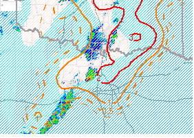
Concerning...Tornado Watch 65...

Valid 012253Z - 020030Z

The severe weather threat for Tornado Watch 65 continues.

SUMMARY...The severe threat continues across Tornado Watch 65. Very
large (2-3 inch diameter) hail appears to be the main threat, though
a few tornadoes remain possible with the more dominant supercells.

DISCUSSION...Deep-layer ascent from the ejecting mid-level trough is
overspreading the southern Plains, likely contributing to the recent
uptick in convective coverage and intensity over southwestern into
central OK. Despite persistent cloud cover and the presence of a
broader rain shield overspreading western into central OK, adequate
deep-layer shear and overall buoyancy will still support an
appreciable severe threat into the evening. The 19Z OUN observed
sounding showed 9 C/km mid-level lapse rates atop a capping
inversion, which has been gradually eroding with time. Regional
VADs, the 19Z observed sounding, and 22Z mesoanalysis, all depict
elongated hodographs, with over 70 kts of effective bulk shear
present. The very steep mid-level lapse rates and strong effective
bulk shear all suggest that large hail (some stones falling within
the 2-3 inch diameter range) will be possible with any more
persistent, mature supercells that can develop. Despite current
meager low-level shear, an increase in low-level jet intensity may
boost SRH later this evening, potentially accompanied by an
increasing tornado threat, especially in eastern OK.

..Squitieri.. 04/01/2024

...Please see http://www.spc.noaa.gov for graphic product...

ATTN...WFO...TSA...FWD...OUN...SJT...
0 likes   
Winter time post are almost exclusively focused on the DFW area.

User avatar
bubba hotep
S2K Supporter
S2K Supporter
Posts: 5610
Joined: Wed Dec 28, 2016 1:00 am
Location: Collin County Texas

Re: Texas Spring 2024

#362 Postby bubba hotep » Mon Apr 01, 2024 6:11 pm

Svr Tstorm watch expanded eastward to include most of DFW. Collin Count and points NE still not covered under a watch. Will Tornado Watch get expanded eastward?
0 likes   
Winter time post are almost exclusively focused on the DFW area.

User avatar
txtwister78
Category 5
Category 5
Posts: 1085
Joined: Wed Jan 30, 2019 12:56 pm
Location: San Antonio

Re: Texas Spring 2024

#363 Postby txtwister78 » Mon Apr 01, 2024 6:19 pm

Monster just west of St. Louis Missouri.
0 likes   

Ntxw
Storm2k Moderator
Storm2k Moderator
Posts: 21565
Joined: Wed Oct 21, 2009 6:34 pm
Location: DFW, Texas

Re: Texas Spring 2024

#364 Postby Ntxw » Mon Apr 01, 2024 6:44 pm

Looks like that northern DFW cell has a hail core going into Denton county. Collin County after.

St Louis yikes.
1 likes   
The above post and any post by Ntxw is NOT an official forecast and should not be used as such. It is just the opinion of the poster and may or may not be backed by sound meteorological data. It is NOT endorsed by any professional institution including Storm2k. For official information, please refer to NWS products.

  Help support Storm2K!
Help Support Storm2K

HockeyTx82
S2K Supporter
S2K Supporter
Posts: 2035
Joined: Tue Oct 27, 2009 11:17 am
Location: Ponder, TX

Re: Texas Spring 2024

#365 Postby HockeyTx82 » Mon Apr 01, 2024 6:49 pm

Ntxw wrote:Looks like that northern DFW cell has a hail core going into Denton county. Collin County after.

St Louis yikes.


I'm thinking the worst of that hill core will pass just South of me.

Looks like Justin and Northlake will get it. I've warned my cubscout families
1 likes   
Don't hold me accountable for anything I post on this forum. Leave the real forecasting up to the professionals.

Location: Ponder, TX (all observation posts are this location unless otherwise noted)

User avatar
bubba hotep
S2K Supporter
S2K Supporter
Posts: 5610
Joined: Wed Dec 28, 2016 1:00 am
Location: Collin County Texas

Re: Texas Spring 2024

#366 Postby bubba hotep » Mon Apr 01, 2024 6:57 pm

Ntxw wrote:Looks like that northern DFW cell has a hail core going into Denton county. Collin County after.

St Louis yikes.


That cell kind of pulsed down during a reorganization attempt but seems to ramping back up. Could be trouble with a Significant Tornado Parameter (using 0-500m SRH) of 2+ out in front.

Image
0 likes   
Winter time post are almost exclusively focused on the DFW area.

User avatar
txtwister78
Category 5
Category 5
Posts: 1085
Joined: Wed Jan 30, 2019 12:56 pm
Location: San Antonio

Re: Texas Spring 2024

#367 Postby txtwister78 » Mon Apr 01, 2024 7:01 pm

Latest HRRR now has supercells entering SA metro between 9-10PM.
2 likes   

User avatar
bubba hotep
S2K Supporter
S2K Supporter
Posts: 5610
Joined: Wed Dec 28, 2016 1:00 am
Location: Collin County Texas

Re: Texas Spring 2024

#368 Postby bubba hotep » Mon Apr 01, 2024 7:03 pm

txtwister78 wrote:Latest HRRR now has supercells entering SA metro between 9-10PM.


Storms in Texas seem to be holding together better than early runs of the hi-res models showed.
2 likes   
Winter time post are almost exclusively focused on the DFW area.

User avatar
ElectricStorm
Category 5
Category 5
Posts: 4627
Age: 23
Joined: Tue Aug 13, 2019 11:23 pm
Location: Skiatook, OK / Norman, OK

Re: Texas Spring 2024

#369 Postby ElectricStorm » Mon Apr 01, 2024 7:15 pm

Most of the action in OK has been north of OKC so far but recent HRRR runs have shown another round around 10pm so maybe there is still some hope.

Also looks like there was a brief tornado near Kingfisher earlier
0 likes   
I am in no way a professional. Take what I say with a grain of salt as I could be totally wrong. Please refer to the NHC, NWS, or SPC for official information.

Boomer Sooner!

User avatar
bubba hotep
S2K Supporter
S2K Supporter
Posts: 5610
Joined: Wed Dec 28, 2016 1:00 am
Location: Collin County Texas

Re: Texas Spring 2024

#370 Postby bubba hotep » Mon Apr 01, 2024 7:31 pm

Earlier, it looked like the issue would be coverage with a concern for discrete storms moving through DFW. Now, it looks like things are going to line out.
0 likes   
Winter time post are almost exclusively focused on the DFW area.

Brent
S2K Supporter
S2K Supporter
Posts: 37146
Age: 35
Joined: Sun May 16, 2004 10:30 pm
Location: Tulsa Oklahoma
Contact:

Re: Texas Spring 2024

#371 Postby Brent » Mon Apr 01, 2024 7:37 pm

Meanwhile I may shoot the gap between storms unless something else forms :spam:

Just saw 3 cars at my apartment complex with a simple blue tarp on them :lol:
1 likes   
#neversummer

User avatar
ElectricStorm
Category 5
Category 5
Posts: 4627
Age: 23
Joined: Tue Aug 13, 2019 11:23 pm
Location: Skiatook, OK / Norman, OK

Re: Texas Spring 2024

#372 Postby ElectricStorm » Mon Apr 01, 2024 7:54 pm

Moderate risk dropped but still an interesting event tonight. New storms going up SW of here. Going to be an interesting night
1 likes   
I am in no way a professional. Take what I say with a grain of salt as I could be totally wrong. Please refer to the NHC, NWS, or SPC for official information.

Boomer Sooner!

User avatar
bubba hotep
S2K Supporter
S2K Supporter
Posts: 5610
Joined: Wed Dec 28, 2016 1:00 am
Location: Collin County Texas

Re: Texas Spring 2024

#373 Postby bubba hotep » Mon Apr 01, 2024 9:19 pm

Overall, pretty good. Rainfall was more widespread than expected, with DFW picking up 1/2", and SVR weather was pretty low end.
1 likes   
Winter time post are almost exclusively focused on the DFW area.

User avatar
ElectricStorm
Category 5
Category 5
Posts: 4627
Age: 23
Joined: Tue Aug 13, 2019 11:23 pm
Location: Skiatook, OK / Norman, OK

Re: Texas Spring 2024

#374 Postby ElectricStorm » Mon Apr 01, 2024 9:52 pm

Really nice non severe line coming through here now. Thick cloud cover all day really hurt todays tornado potential in OK as a whole but we still did see a few north of I-44 (and still could get a couple in southern OK overnight). Large hail threat seemed to underperform overall which is good.
3 likes   
I am in no way a professional. Take what I say with a grain of salt as I could be totally wrong. Please refer to the NHC, NWS, or SPC for official information.

Boomer Sooner!

Brent
S2K Supporter
S2K Supporter
Posts: 37146
Age: 35
Joined: Sun May 16, 2004 10:30 pm
Location: Tulsa Oklahoma
Contact:

Re: Texas Spring 2024

#375 Postby Brent » Mon Apr 01, 2024 10:03 pm

Line trying to blow up over here but yeah the lack of big hail has been the story today

Definitely a couple tornadoes at least north of the metro earlier
0 likes   
#neversummer

User avatar
ElectricStorm
Category 5
Category 5
Posts: 4627
Age: 23
Joined: Tue Aug 13, 2019 11:23 pm
Location: Skiatook, OK / Norman, OK

Re: Texas Spring 2024

#376 Postby ElectricStorm » Mon Apr 01, 2024 10:23 pm

Brent wrote:Line trying to blow up over here but yeah the lack of big hail has been the story today

Definitely a couple tornadoes at least north of the metro earlier

Yeah the 45# hail area was pretty much a total bust. I don't even think I saw a single warning for 2+ inch hail anywhere in the moderate risk today.

Really weird how none of the models picked up on the scattered rain throughout the day, if it wasn't for that maybe we would have seen more.
0 likes   
I am in no way a professional. Take what I say with a grain of salt as I could be totally wrong. Please refer to the NHC, NWS, or SPC for official information.

Boomer Sooner!

User avatar
txtwister78
Category 5
Category 5
Posts: 1085
Joined: Wed Jan 30, 2019 12:56 pm
Location: San Antonio

Re: Texas Spring 2024

#377 Postby txtwister78 » Mon Apr 01, 2024 10:25 pm

Big storm with hail moving through San Antonio
1 likes   

User avatar
txtwister78
Category 5
Category 5
Posts: 1085
Joined: Wed Jan 30, 2019 12:56 pm
Location: San Antonio

Re: Texas Spring 2024

#378 Postby txtwister78 » Mon Apr 01, 2024 10:28 pm

1 likes   

User avatar
South Texas Storms
Professional-Met
Professional-Met
Posts: 4040
Joined: Thu Jun 24, 2010 12:28 am
Location: Houston, TX

Re: Texas Spring 2024

#379 Postby South Texas Storms » Mon Apr 01, 2024 10:46 pm

txtwister78 wrote:Big storm with hail moving through San Antonio


Yep, several reports of quarter to golf ball size hail across SA this hour. HRRR did a pretty good job indicating the potential for an isolated severe storm impacting SA this evening.
1 likes   

User avatar
Cpv17
Category 5
Category 5
Posts: 4442
Joined: Wed Dec 07, 2016 2:24 pm
Location: Wharton/El Campo, TX

Re: Texas Spring 2024

#380 Postby Cpv17 » Mon Apr 01, 2024 10:46 pm

txtwister78 wrote:Big storm with hail moving through San Antonio


There was an even bigger storm that passed through the southern side of Fredicksburg about an hour or so ago.
0 likes   


Return to “USA & Caribbean Weather”

Who is online

Users browsing this forum: No registered users and 24 guests