Texas Fall-2016
Moderator: S2k Moderators
Forum rules
The posts in this forum are NOT official forecast and should not be used as such. They are just the opinion of the poster and may or may not be backed by sound meteorological data. They are NOT endorsed by any professional institution or STORM2K.
-
Brent
- S2K Supporter

- Posts: 38739
- Age: 37
- Joined: Sun May 16, 2004 10:30 pm
- Location: Tulsa Oklahoma
- Contact:
Re: Texas Fall-2016
Didn't even rain really here in Wylie... kind of disappointing.
I'm ready for some real fall...
I'm ready for some real fall...
0 likes
#neversummer
Re: Texas Fall-2016
My house as well as most of the city of Austin got lucky Last night with redevelopment of multiple showers that started forming over Hays around 9p.m. Then merged and grew in areal coverage as the cluster moved north/northeast over the city and the eastern half of Travis County. Ended up getting 3/4s of an inch. A very nice surprise.
0 likes
Resident Rain Miser
I am a weather hobbyist living 3.5 miles south of Downtown Austin and in no way or fashion should anything I say concerning forecasts be taken seriously. Please check your local NWS for accurate weather forecasting and conditions.
I am a weather hobbyist living 3.5 miles south of Downtown Austin and in no way or fashion should anything I say concerning forecasts be taken seriously. Please check your local NWS for accurate weather forecasting and conditions.
-
weatherdude1108
- Category 5

- Posts: 4228
- Joined: Tue Dec 13, 2011 1:04 pm
- Location: Northwest Austin/Cedar Park, TX
Re: Texas Fall-2016
JDawg512 wrote:My house as well as most of the city of Austin got lucky Last night with redevelopment of multiple showers that started forming over Hays around 9p.m. Then merged and grew in areal coverage as the cluster moved north/northeast over the city and the eastern half of Travis County. Ended up getting 3/4s of an inch. A very nice surprise.
It rained nicely at the office today in north Austin. Not a drop at my house though. Congrats on your 3/4 inch!
0 likes
The preceding post is NOT an official forecast, and should not be used as such. It is only the opinion of the poster and may or may not be backed by sound meteorological data. It is NOT endorsed by any professional institution including storm2k.org. For Official Information please refer to the NHC and NWS products.
Re: Texas Fall-2016
Cold front late week is starting to look potent. For DFW some models have lows in the 40s and highs in the 50s.
0 likes
The above post and any post by Ntxw is NOT an official forecast and should not be used as such. It is just the opinion of the poster and may or may not be backed by sound meteorological data. It is NOT endorsed by any professional institution including Storm2k. For official information, please refer to NWS products.
-
TexasBreeze
- Tropical Depression

- Posts: 81
- Joined: Mon Jul 07, 2014 12:50 pm
Re: Texas Fall-2016
Is the cold front caused by the remains of Songda moving into the northwest US maybe? Houston may even see low 50's/upper 40's late week!
0 likes
Re: Texas Fall-2016
TexasBreeze wrote:Is the cold front caused by the remains of Songda moving into the northwest US maybe? Houston may even see low 50's/upper 40's late week!
Quite the opposite actually. Songda was absorbed into the fast moving Pacific jet that is blasting into the PAC NW now with the superstorm. It's actually a cause of the warm up this week. Low heights and heavy rains in the PacNW is a firehose for us, pumps heat and ridge in the fall and winter. Late week if there is a typhoon connection will be the recurve and amplification of the NPAC by Haima which will likely be a cat 5 supertyphoon
0 likes
The above post and any post by Ntxw is NOT an official forecast and should not be used as such. It is just the opinion of the poster and may or may not be backed by sound meteorological data. It is NOT endorsed by any professional institution including Storm2k. For official information, please refer to NWS products.
-
Brent
- S2K Supporter

- Posts: 38739
- Age: 37
- Joined: Sun May 16, 2004 10:30 pm
- Location: Tulsa Oklahoma
- Contact:
Re: Texas Fall-2016
Looks like a much cooler pattern will definitely set in after Wednesday/Thursday this week... still not seeing any signs of good rains though.
0 likes
#neversummer
- Tireman4
- S2K Supporter

- Posts: 5903
- Age: 60
- Joined: Fri Jun 30, 2006 1:08 pm
- Location: Humble, Texas
- Contact:
Re: Texas Fall-2016
The front is coming. The front is coming. Thursday! Meanwhile, Houston roasts. Uhhgh...
Last edited by Tireman4 on Mon Oct 17, 2016 8:10 am, edited 1 time in total.
0 likes
Re: Texas Fall-2016
As noted in a previous post we are on the verge of explosive snow growth over Eurasia. The predominant -AO has been the story this October midway and continues. SAI will be on our side this year.
0 likes
The above post and any post by Ntxw is NOT an official forecast and should not be used as such. It is just the opinion of the poster and may or may not be backed by sound meteorological data. It is NOT endorsed by any professional institution including Storm2k. For official information, please refer to NWS products.
Re: Texas Fall-2016
TexasF6 wrote:What's this Halloween storm local mets are talking about in Austin?
I have yet to hear about this Halloween storm that you speak of. What kind of storm?
0 likes
Resident Rain Miser
I am a weather hobbyist living 3.5 miles south of Downtown Austin and in no way or fashion should anything I say concerning forecasts be taken seriously. Please check your local NWS for accurate weather forecasting and conditions.
I am a weather hobbyist living 3.5 miles south of Downtown Austin and in no way or fashion should anything I say concerning forecasts be taken seriously. Please check your local NWS for accurate weather forecasting and conditions.
-
weatherdude1108
- Category 5

- Posts: 4228
- Joined: Tue Dec 13, 2011 1:04 pm
- Location: Northwest Austin/Cedar Park, TX
Re: Texas Fall-2016
JDawg512 wrote:TexasF6 wrote:What's this Halloween storm local mets are talking about in Austin?
I have yet to hear about this Halloween storm that you speak of. What kind of storm?
That's what I was wondering(?). I know we had a storm right before Halloween last year.
0 likes
The preceding post is NOT an official forecast, and should not be used as such. It is only the opinion of the poster and may or may not be backed by sound meteorological data. It is NOT endorsed by any professional institution including storm2k.org. For Official Information please refer to the NHC and NWS products.
-
Brent
- S2K Supporter

- Posts: 38739
- Age: 37
- Joined: Sun May 16, 2004 10:30 pm
- Location: Tulsa Oklahoma
- Contact:
Re: Texas Fall-2016
weatherdude1108 wrote:JDawg512 wrote:TexasF6 wrote:What's this Halloween storm local mets are talking about in Austin?
I have yet to hear about this Halloween storm that you speak of. What kind of storm?
That's what I was wondering(?). I know we had a storm right before Halloween last year.
I've seen some hints way out in fantasy land, but it's so far out right now. The GFS isn't that wet... it has a storm but not anything extreme.
0 likes
#neversummer
- amawea
- S2K Supporter

- Posts: 385
- Age: 74
- Joined: Mon Aug 09, 2004 3:36 pm
- Location: Horseshoe Bend, Ar. but from Baytown, Tx
Re: Texas Fall-2016
Brent wrote:weatherdude1108 wrote:JDawg512 wrote:
I have yet to hear about this Halloween storm that you speak of. What kind of storm?
That's what I was wondering(?). I know we had a storm right before Halloween last year.
I've seen some hints way out in fantasy land, but it's so far out right now. The GFS isn't that wet... it has a storm but not anything extreme.
I think what TexasF6 is referring to is a post by Captain Crunch the other day about what kind of weather we may have Halloween, If you don't know Captain Crunch basis his winter weather prediction on what kind of weather we have on Halloween.
0 likes
Re: Texas Fall-2016
Thank you all! So one of our local promets said a Halloween rainstorm, flooding etc was brewing? But he wasn't sure, but gave some warning. Must have been a model he trusted. The big one is coming Thursday ehh? Bring it ON!!! I, for one, am done with this biking weather!!!
0 likes
Re: Texas Fall-2016
Brent wrote:weatherdude1108 wrote:JDawg512 wrote:
I have yet to hear about this Halloween storm that you speak of. What kind of storm?
That's what I was wondering(?). I know we had a storm right before Halloween last year.
I've seen some hints way out in fantasy land, but it's so far out right now. The GFS isn't that wet... it has a storm but not anything extreme.
There is a crazy block that is about to unfold over Europe and then Eurasia. It is a tie in to the wild -AO. Whether this blockage will reflect into a significant North American storm is yet to be seen but it's curious no less. Some exciting things going on that have not yet set foot in our neck of the woods but will take time. It may result in a severe -NAO late month and a clog in the weather pattern.
0 likes
The above post and any post by Ntxw is NOT an official forecast and should not be used as such. It is just the opinion of the poster and may or may not be backed by sound meteorological data. It is NOT endorsed by any professional institution including Storm2k. For official information, please refer to NWS products.
-
aggiecutter
- Category 5

- Posts: 1755
- Joined: Thu Oct 14, 2004 9:22 pm
- Location: Texarkana
- Tireman4
- S2K Supporter

- Posts: 5903
- Age: 60
- Joined: Fri Jun 30, 2006 1:08 pm
- Location: Humble, Texas
- Contact:
Re: Texas Fall-2016
Dang, the next three days are going to be near record setters. Lovely. Just lovely. Thursday cannot get here fast enough. My bikes ( morning) and runs ( afternoon) will be sweatfests..well this morning already was.
00
FXUS64 KHGX 171203
AFDHGX
Area Forecast Discussion
National Weather Service Houston/Galveston TX
703 AM CDT Mon Oct 17 2016
.AVIATION...
Low MVFR/IFR decks generally remaining north of Houston metro
though 14-15Z. Metro and southern terminals may experience a
brief hour or two of periodic MVFR decks with fog being confined
to more wind sheltered (CXO) or rural open expanse (LBX) hubs.
Region-wide scattering out past 15Z...VFR through the day. Near
20 knot off-the-surface southerlies will mix down this afternoon,
especially west of metro, translating to 10-15 mph sustained surface
winds. Little change in the large scale weather pattern suggests a
repeat concerning early Tuesday morning (returning) low MVFR ceilings.
31
&&
.PREV DISCUSSION... /ISSUED /
DISCUSSION...
Unseasonably warm and near record high temperatures will continue
for a couple more days across much of Southeast Texas with a
persistent onshore flow at the surface and ridging in the mid/upper
levels. Heights fall starting on Wednesday as the ridge moves off
to the east, and this will help to lower our afternoon highs a couple
degrees. The well advertised strong cold front and associated
increasing rain chances are still on schedule to move across
Southeast Texas Wednesday night through Thursday. It will become
breezy (especially near the coast) and cooler behind the front as
surface high pressure begins to build into the area. A northwest
flow aloft and offshore surface winds will help to bring our area
mostly clear skies with lows generally in the 50s and highs
generally in the 70s Thursday night through Saturday night. Onshore
winds come back to the area beginning on Sunday as the surface high
moves off to the east resulting in warming temperatures, and at this
time it looks like this trend will persist through at least the first
half of next week.
Here are area record highs for the next two days:
Today Tuesday
-College Station: 92 in 1915 92 in 2004
-Houston IAH: 93 in 1895 96 in 1895
-Houston HOU: 91 in 1972 94 in 1947
-Galveston: 88 in 2003 87 in 2007
42
MARINE...
Generally light, to occasionally moderate, southeastern flow over 2
to 3 foot nearshore/3 to 4 foot offshore seas through mid week. The
cold front (or pre-frontal wind shift trough) is timed to reach the
coast and local Gulf waters Thursday morning with cold air advection
and a tight backside gradient strengthening offshore winds early
Friday. Areawide precipitation will fill in just downstream of the
approaching front Wednesday through early Friday. Friday morning
advisory level winds driving up nearshore seas to 5 feet/offshore to
around 7 or 8 feet. The progressive eastward movement of the exiting
trough will have western high pressure filling in its wake Saturday.
Thus, conditions will significantly improve Saturday into Sunday. A
moderate northeast wind to start out the weekend will weaken and
veer more east Sunday, 2 to 4 foot average seas Saturday will lower
to around 2 to 3 feet Sunday. 31
&&
.PRELIMINARY POINT TEMPS/POPS...
College Station (CLL) 91 72 91 71 89 / 10 10 10 10 20
Houston (IAH) 92 72 92 71 89 / 10 10 10 10 30
Galveston (GLS) 87 77 87 78 86 / 10 10 10 20 30
&&
.HGX WATCHES/WARNINGS/ADVISORIES...
TX...NONE.
GM...NONE.
&&
$$
Discussion...42
Aviation/Marine...31
0 likes
- TeamPlayersBlue
- Category 5

- Posts: 3530
- Joined: Tue Feb 02, 2010 1:44 am
- Location: Denver/Applewood, CO
Re: Texas Fall-2016
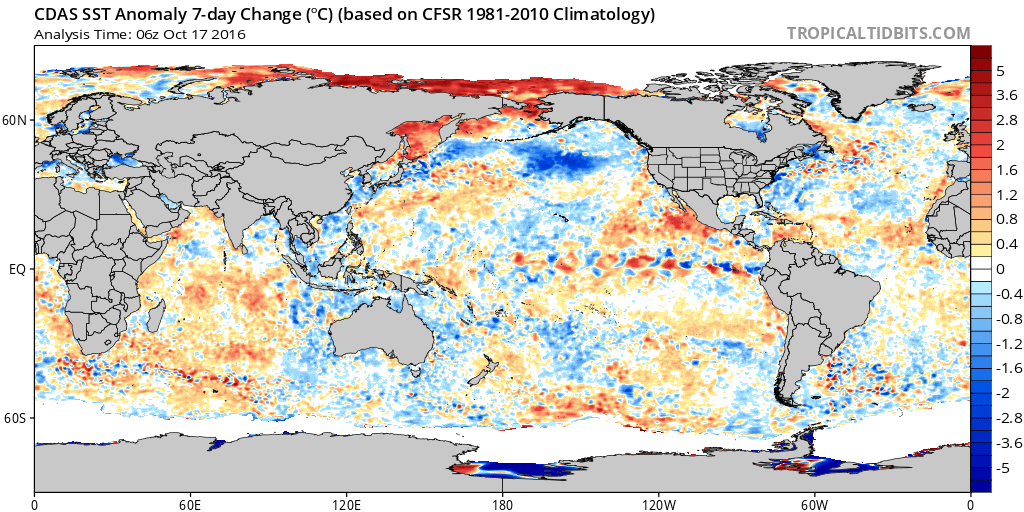
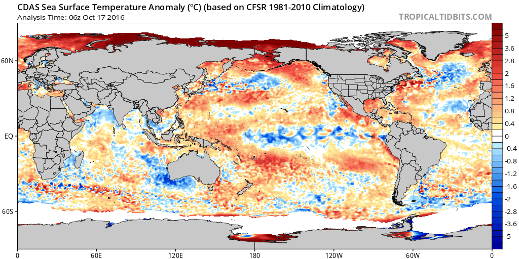
Ntx, im getting worried! Some cooling has taken place in the area which could lead to a massive -EPO this winter. Last week or so there has been a massive low bringing cooler air in. Hopefully it stays/becomes even warmer in the GOA!


0 likes
Personal Forecast Disclaimer:
The posts in this forum are NOT official forecast and should not be used as such. They are just the opinion of the poster and may or may not be backed by sound meteorological data. They are NOT endorsed by any professional institution or storm2k.org. For official information, please refer to the NHC and NWS products.
The posts in this forum are NOT official forecast and should not be used as such. They are just the opinion of the poster and may or may not be backed by sound meteorological data. They are NOT endorsed by any professional institution or storm2k.org. For official information, please refer to the NHC and NWS products.
Return to “USA & Caribbean Weather”
Who is online
Users browsing this forum: AnnularCane, Quixotic, Stratton23 and 52 guests


