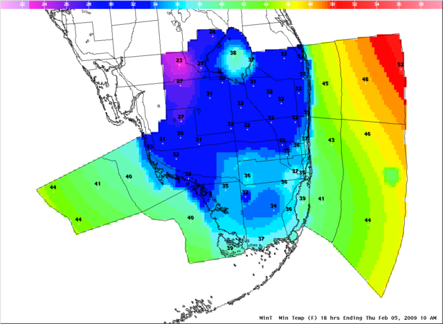
Florida Weather

U.S. & Caribbean Weather Discussions and Severe Weather Events

Moderator: S2k Moderators

Forum rules

The posts in this forum are NOT official forecast and should not be used as such. They are just the opinion of the poster and may or may not be backed by sound meteorological data. They are NOT endorsed by any professional institution or STORM2K.

Help Support Storm2K
Message
Author
User avatar
HURAKAN
Professional-Met
Professional-Met
Posts: 46086
Age: 38
Joined: Thu May 20, 2004 4:34 pm
Location: Key West, FL
Contact:

#3801 Postby HURAKAN » Thu Feb 05, 2009 11:52 am

Image

Coldest since 2003.
0 likes   

jinftl
Category 5
Category 5
Posts: 4312
Joined: Tue Aug 31, 2004 4:47 pm
Location: fort lauderdale, fl

Re:

#3802 Postby jinftl » Thu Feb 05, 2009 12:00 pm

Temps were fairly uniform from coastal locations to areas 10-15 miles inland in south florida...haven't seen any reports of below freezing temps in miami-dade or broward last night.

The cold snap in January featured colder temps in inland locations and overall a bigger range of temps from inland (areas of west Broward like Coral Springs dipped a bit below freezing then) to the coast (airports stayed above 40)....probably a function of the winds not dropping off completely last night, thereby preventing optimum radiational cooling.


Across the peninsula, winds not dropping off as much as expected helped to keep temps above the forecasted numbers from yesterday evening....and reduced the number of hours that any below freezing temps took place (esp in the growing regions...prelim numbers show the January cold snap producing colder temps than many areas saw last night).

Prelim lows from NWS offices:

Orlando 30F (forecast was 25F)
Vero Beach 32F (forecast was 29F)
Melbourne 31F (forecast was 27F)
Tampa 32F (forecast was 28F)
Fort Myers 34F (forecast was 31F)


HURAKAN wrote:
Coldest since 2003.
0 likes   

JonathanBelles
Professional-Met
Professional-Met
Posts: 11430
Age: 35
Joined: Sat Dec 24, 2005 9:00 pm
Location: School: Florida State University (Tallahassee, FL) Home: St. Petersburg, Florida
Contact:

#3803 Postby JonathanBelles » Thu Feb 05, 2009 1:18 pm

Got down to about 33 here, but the wind was horrible last night. I went out earlier when it was 44 and it was great outside! Nice hot sun, very little wind. Ill take 30 with calm winds over 60 and 20mph winds anyday!
0 likes   

User avatar
abajan
S2K Supporter
S2K Supporter
Posts: 4305
Age: 61
Joined: Sun Sep 07, 2003 5:10 am
Location: Barbados

#3804 Postby abajan » Thu Feb 05, 2009 2:24 pm

I never knew it could get that cold in the lower part of the Florida peninsula. I figured the lowest it could get in areas like Miami and Homestead was around 50 Fahrenheit or so. Wow! :eek:
0 likes   

User avatar
HURAKAN
Professional-Met
Professional-Met
Posts: 46086
Age: 38
Joined: Thu May 20, 2004 4:34 pm
Location: Key West, FL
Contact:

Re:

#3805 Postby HURAKAN » Thu Feb 05, 2009 2:39 pm

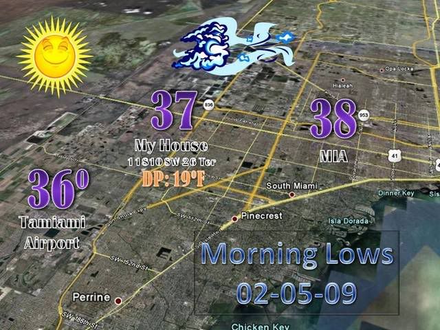
abajan wrote:I never knew it could get that cold in the lower part of the Florida peninsula. I figured the lowest it could get in areas like Miami and Homestead was around 50 Fahrenheit or so. Wow! :eek:


Miami record low temperature is 27°F (-2.8°C). It was recorded on February 3rd, 1917. The Weather Bureau (now National Weather Service) was established in 1911.
0 likes   

User avatar
HURAKAN
Professional-Met
Professional-Met
Posts: 46086
Age: 38
Joined: Thu May 20, 2004 4:34 pm
Location: Key West, FL
Contact:

#3806 Postby HURAKAN » Thu Feb 05, 2009 2:45 pm

Image
0 likes   

User avatar
Tampa Bay Hurricane
Category 5
Category 5
Posts: 5598
Age: 37
Joined: Fri Jul 22, 2005 7:54 pm
Location: St. Petersburg, FL

#3807 Postby Tampa Bay Hurricane » Thu Feb 05, 2009 8:52 pm

It is really cold outside right now, but at least it is not windy
0 likes   

User avatar
jdray
Category 3
Category 3
Posts: 853
Joined: Tue Aug 31, 2004 10:07 pm
Location: NE Florida

Re: Florida Weather Thread: Arctic air

#3808 Postby jdray » Thu Feb 05, 2009 8:59 pm

Currently 27F @ 9PM @ Cecil Field.

Only forecast to hit 22F, but I think that might be blown unless the winds pick up. (not likely)
0 likes   

User avatar
gatorcane
S2K Supporter
S2K Supporter
Posts: 23703
Age: 47
Joined: Sun Mar 13, 2005 3:54 pm
Location: Boca Raton, FL

#3809 Postby gatorcane » Thu Feb 05, 2009 9:52 pm

Look at the temps across much of the Western part of the state. It's 39F in Tampa already and its only 9pm EST! Its also approaching 32F already across much of Southern Pasco and that line is creeping into the Northern Part of Pinellas county now. With no NNW wind vector to protect the west coast tonight it, its likely that tonight is the big freeze event for the West coast of Florida including Tampa...its likely there will be widespread plant damage as well because frost is a good possibility with near calm winds.

Note how the North to NNE wind vector is keeping temps up along the East Coast of Florida, especially SE Florida:

Image

Note dewpoints also, creeping up along SE Coast of Florida, but dangerously low across the entire rest of the state

Image
0 likes   

User avatar
DESTRUCTION5
Category 5
Category 5
Posts: 4430
Age: 44
Joined: Wed Sep 03, 2003 11:25 am
Location: Stuart, FL

#3810 Postby DESTRUCTION5 » Thu Feb 05, 2009 10:08 pm

Just hit 41 here in stuart and its 10PM...Were going mid 30's easy...
0 likes   

Scorpion

#3811 Postby Scorpion » Thu Feb 05, 2009 11:11 pm

Down to 34 here at 11.. looks like 20's are very attainable
0 likes   

User avatar
gatorcane
S2K Supporter
S2K Supporter
Posts: 23703
Age: 47
Joined: Sun Mar 13, 2005 3:54 pm
Location: Boca Raton, FL

Re:

#3812 Postby gatorcane » Thu Feb 05, 2009 11:17 pm

DESTRUCTION5 wrote:Just hit 41 here in stuart and its 10PM...Were going mid 30's easy...


Depends where you are in Stuart. Along the coast (say within about 2 miles), its not likely it will happen. If you are inland and under 10 miles then those mid 30s would happen earlier in the night with gradual warming up until sunset.

Keep in mind the big Arctic High is moving off to the East over Northern Florida tonight and will be out in the Western Atlantic by this time tomorrow. Wind vectors will start to veer to the NNE later tonight and close to daybreak which will actually allow temps to rise over the East Coast of Florida as we approach sunrise.

Mesoanalysis shows wind vectors now starting to hint at a more NNE flow. By this time tomorrow expect nearly E to ENE flow and mostly E to SE flow by later on in the weekend:

Image
0 likes   

JonathanBelles
Professional-Met
Professional-Met
Posts: 11430
Age: 35
Joined: Sat Dec 24, 2005 9:00 pm
Location: School: Florida State University (Tallahassee, FL) Home: St. Petersburg, Florida
Contact:

#3813 Postby JonathanBelles » Thu Feb 05, 2009 11:37 pm

37°F and Frost right now!
0 likes   

psyclone
S2K Supporter
S2K Supporter
Posts: 4802
Joined: Wed Aug 24, 2005 9:04 pm
Location: palm harbor fl

#3814 Postby psyclone » Fri Feb 06, 2009 12:00 am

OK just went out for a little frigid weather recon with the dog (he was not impressed). first checked my car which is not parked directly under trees has trees in the vicinity and the top was covered in dew. have a current temp of 37. a short walk to a nearby open field revealed frost. also other cars parked in more open areas have frosted tops. it a classic radiational cooling night here but it is not as cool as the event back around jan 21 or thereabouts when the onset of frost took place much sooner. This leaves me cautiously optimistic as tonight's cold duration will be shorter than the late january event which only produced negligible damage to the most sensitive tropicals.
0 likes   

JonathanBelles
Professional-Met
Professional-Met
Posts: 11430
Age: 35
Joined: Sat Dec 24, 2005 9:00 pm
Location: School: Florida State University (Tallahassee, FL) Home: St. Petersburg, Florida
Contact:

#3815 Postby JonathanBelles » Fri Feb 06, 2009 2:07 am

its 35 out there now and not too bad! Frost is thick enough on the cars to write in it.
0 likes   

User avatar
dizzyfish
S2K Supporter
S2K Supporter
Posts: 1520
Joined: Fri Sep 16, 2005 7:56 am
Location: New Port Richey, FL

Re: Florida Weather Thread: Arctic air

#3816 Postby dizzyfish » Fri Feb 06, 2009 8:08 am

According to the closest Wunderground station my low was 24.3. Very heavy frost - still!
Everything is white in my yard! :froze:

Come on sun - warm us up.
0 likes   

jinftl
Category 5
Category 5
Posts: 4312
Joined: Tue Aug 31, 2004 4:47 pm
Location: fort lauderdale, fl

Re: Florida Weather Thread: Arctic air

#3817 Postby jinftl » Fri Feb 06, 2009 11:29 am

What goes down in florida invariably goes back up.....current temps with the 24-hour temperature change from 11am yesterday in ( ).

FLORIDA REGIONAL WEATHER ROUNDUP
1100 AM EST FRI FEB 06 2009

PENSACOLA 54 (+16)
CRESTVIEW 55 (+16)
PANAMA CITY 53 (+15)
APALACHICOLA 54 (+14)
TALLAHASSEE 49 (+12)
GAINESVILLE 50 (+14)
JACKSONVILLE 48 (+13)
OCALA 50 (+13)
ORLANDO INTL 55 (+14)
LAKELAND 55 (+16)
OKEECHOBEE 61 (+15)
DAYTONA BEACH 55 (+13)
MELBOURNE 58 (+11)
VERO BEACH 60 (+11)
FT PIERCE 61 (+13)
TAMPA 55 (+11)
PUNTA GORDA 59 (+15)
FORT MYERS 57 (+14)
NAPLES 61 (+16)
KEY WEST INTL 60 (+9)
W PALM BEACH 62 (+11)
FT LAUDERDALE 60 (+8)
MIAMI 59 (+9)
0 likes   

frankthetank
Category 2
Category 2
Posts: 527
Joined: Mon Aug 09, 2004 6:16 pm
Location: La Crosse, WI

Re: Florida Weather Thread: Arctic air

#3818 Postby frankthetank » Fri Feb 06, 2009 12:02 pm

Miami should be in the 80's most of next week.

Wouldn't it be crazy if there were records going back about a 10,000 years (i mean real records, daily hi/lo/precip)... Could you imagine some of the temps you would find in there, not to mention rainfall and other crazy stats. 100 years of data is just a blink of an eye...Ever wonder if Miami has ever been in the single digits? How much snow has really fallen? Crazy stuff.
0 likes   

jinftl
Category 5
Category 5
Posts: 4312
Joined: Tue Aug 31, 2004 4:47 pm
Location: fort lauderdale, fl

Re: Florida Weather Thread: Arctic air

#3819 Postby jinftl » Fri Feb 06, 2009 1:00 pm

Great image of onshore flow (with corresponding cirrus deck of clouds) starting to move over south florida....say goodbye to lows in the 30's and 40's and even 50's along the immediate coast tonight....forecast low in Miami is a more seasonable 60F tonight. Dewpoints across se fl have risen to the 45-50 deg range...and rising.

Image
0 likes   

User avatar
gatorcane
S2K Supporter
S2K Supporter
Posts: 23703
Age: 47
Joined: Sun Mar 13, 2005 3:54 pm
Location: Boca Raton, FL

Re: Florida Weather Thread: Arctic air

#3820 Postby gatorcane » Fri Feb 06, 2009 1:12 pm

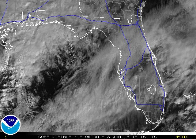
jinftl wrote:Great image of onshore flow (with corresponding cirrus deck of clouds) starting to move over south florida....say goodbye to lows in the 30's and 40's and even 50's along the immediate coast tonight....forecast low in Miami is a more seasonable 60F tonight. Dewpoints across se fl have risen to the 45-50 deg range...and rising.

Image


technically they are stratocumulus clouds (not cirrus) that are being generated from arctic air moving over relatively warmer waters. But you are right, now that the flow is onshore (and strong mind you), low temps will be 60+ near the coast for the forseeable future with mid 50s inland creeping up to the 60s by end of weekend.
0 likes   


Return to “USA & Caribbean Weather”

Who is online

Users browsing this forum: AnnularCane and 57 guests