
Florida Weather
Moderator: S2k Moderators
Forum rules

The posts in this forum are NOT official forecast and should not be used as such. They are just the opinion of the poster and may or may not be backed by sound meteorological data. They are NOT endorsed by any professional institution or STORM2K.
Re: Florida Weather Thread: Warming Up!
Shaping up to be a stellar beach day....temps around 80 before noon....current image from Jupiter Inlet (Palm Beach County)...
0 likes
-
JonathanBelles
- Professional-Met

- Posts: 11430
- Age: 35
- Joined: Sat Dec 24, 2005 9:00 pm
- Location: School: Florida State University (Tallahassee, FL) Home: St. Petersburg, Florida
- Contact:
Re: Florida Weather Thread: Warming Up!

Very cloudy here. This is the cam from bay front, very close to where I will be over the weekend. That is Albert Whitted on the right side.
0 likes
Re: Florida Weather Thread: Warming Up!
Live cam shots verify with current conditions....area of cloud cover on parts of west coast of FL keeping temps down some....but mild to warm afternoon overall statewide
FLORIDA REGIONAL WEATHER ROUNDUP
1200 PM EST THU FEB 12 2009
PENSACOLA NAS MOSUNNY 68
PANAMA CITY SUNNY
APALACHICOLA MOSUNNY 73
TALLAHASSEE SUNNY 71
GAINESVILLE MOSUNNY 73
JACKSONVILLE PTSUNNY 72
ORLANDO INTL CLOUDY 74
DAYTONA BEACH MOSUNNY 78
MELBOURNE MOSUNNY 80
VERO BEACH PTSUNNY 80
FT PIERCE MOSUNNY 80
CLEARWATER PTSUNNY 77
TAMPA CLOUDY 72
ST PETERSBURG CLOUDY 71
FT MYERS CLOUDY 72
KEY WEST NAS MOSUNNY 80
W PALM BEACH MOSUNNY 80
FT LAUDERDALE MOSUNNY 81
MIAMI MOSUNNY 79
0 likes

Re: Florida Weather Thread: Warming Up!
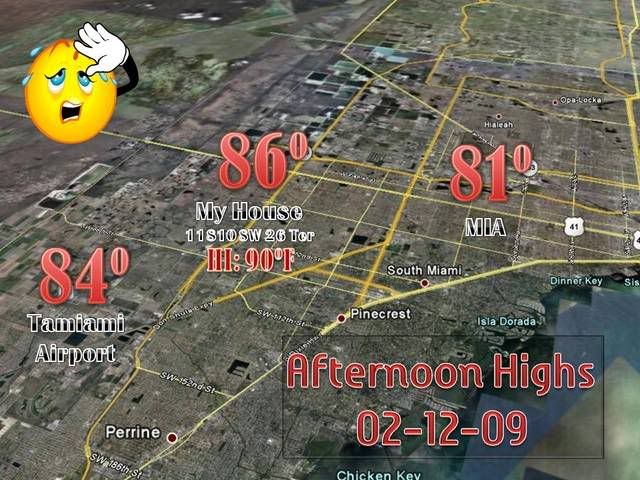
Up to 87.1F as of time of posting in Coral Springs....temps in the mid-80s thoughout western areas of Broward and Miami-Dade this pm....what a difference a week makes!
http://www.wunderground.com/weatherstation/WXDailyHistory.asp?ID=KFLCORAL15
Ocean temps are responding to the warmer weather (esp. compared to last week's chill)....up a few degrees statewide

Link below shows steady increase in ocean temp at Fowey Rocks (off Miami Beach)...rising from the very unusually cool 69 deg to current levels closer to average for this time of year.
http://www.ndbc.noaa.gov/show_plot.php?station=fwyf1&meas=wtmp&uom=E&time_diff=5&time_label=EST
http://www.wunderground.com/weatherstation/WXDailyHistory.asp?ID=KFLCORAL15
Ocean temps are responding to the warmer weather (esp. compared to last week's chill)....up a few degrees statewide
Link below shows steady increase in ocean temp at Fowey Rocks (off Miami Beach)...rising from the very unusually cool 69 deg to current levels closer to average for this time of year.
http://www.ndbc.noaa.gov/show_plot.php?station=fwyf1&meas=wtmp&uom=E&time_diff=5&time_label=EST
0 likes
-
tropicana

- Category 5

- Posts: 8056
- Joined: Sat Sep 27, 2003 6:48 pm
- Location: Niagara Falls, Ontario, Canada
- Contact:
Re: Florida Weather Thread: Warming Up!
And a record 84F has been tied at Daytona Beach FL today , the original record set in 2004.
Also, a new record set at Apalachicola FL with a balmy 76F
WHat a great beach at Jupiter, soooo great the weather, sooo empty the actual beach.
-justin-
Also, a new record set at Apalachicola FL with a balmy 76F
WHat a great beach at Jupiter, soooo great the weather, sooo empty the actual beach.
-justin-
0 likes


Re: Florida Weather Thread: Warming Up!
Beaches packed on southeast florida coast today....sunny and in the 80s...
0 likes
-
Tampa Bay Hurricane

- Category 5
- Posts: 5597
- Age: 38
- Joined: Fri Jul 22, 2005 7:54 pm
- Location: St. Petersburg, FL
Re: Florida Weather Thread: Warming Up!
What a pathetic BUST! No rain- north florida got so much and it missed me today
Load of junk
Load of junk
0 likes
-
Ed Mahmoud
Re: Florida Weather Thread: Warming Up!
Rain starting to fall in DAB.
Race caution is for an accident, but I see drops on the camera lenses...
Race caution is for an accident, but I see drops on the camera lenses...
0 likes
Re: Florida Weather Thread: Warming Up!
Last shot of cold air for the season?
Freeze event not forecast at this time....quite honestly, getting a bit late in the year for that magnitude of cold....but chilly weather nonetheless by local standards. But one way to look at it....one of the last chances to get away without using a/c for what will be months on end.....my electric bill will be appreciative!!!
Per NWS Miami:
VERY STRONG COLD THERMAL ADVECTION WILL OCCUR IMMEDIATELY
FOLLOWING FRONTAL PASSAGE...AS SURFACE RIDGE AXIS SETTLES ACROSS
THE LOWER MISSISSIPPI VALLEY/CENTRAL GULF COAST REGION...ALLOWING
ARCTIC AIR TO SPREAD OVER THE AREA DURING THE NIGHT. ALTHOUGH
AMBIENT AIR TEMPERATURES MAY ONLY FALL INTO THE UPPER 30S
NORTHWEST INTERIOR... WIND CHILLS WILL BE A CONCERN AS PRESSURE
GRADIENT WILL REMAIN STRONG ENOUGH TO MAINTAIN WINDS OF AT LEAST 5
MPH EVEN ACROSS THE INTERIOR. DESPITE ABUNDANT INSOLATION...
TEMPERATURES WILL LIKELY STRUGGLE TO REACH THE UPPER 60S TO AROUND
70 ON FRIDAY...WITH SURFACE HIGH SETTLING OVER THE CENTRAL
PENINSULA SETTING THE STAGE FOR GOOD RADIATIONAL COOLING ON FRIDAY
NIGHT/SATURDAY MORNING. THE POTENTIAL CERTAINLY DOES EXIST FOR A
BRIEF/LIGHT FREEZE ON SATURDAY MORNING ACROSS MAINLY GLADES/HENDRY
AND PERHAPS INLAND PALM BEACH AND COLLIER COUNTIES. HOWEVER...
CONDITIONS ARE SIMPLY TOO MARGINAL AT THIS POINT TO ISSUE A FREEZE
OUTLOOK AND WILL MONITOR TRENDS IN GUIDANCE OVER THE NEXT COUPLE
OF DAYS. A GRADUAL WARMING TREND IS EXPECTED ON SATURDAY...IN
ADVANCE OF ANOTHER BLAST OF COLD AIR THAT WILL ARRIVE ON SUNDAY...
ASSOCIATED WITH CLIPPER SYSTEM DROPPING SOUTHWARD OUT OF
SASKATCHEWAN AND ACROSS THE UPPER MIDWEST. DRY WEATHER IS EXPECTED
THROUGH THE PERIOD...AND WITH MUCH UNCERTAINTY REGARDING TIMING OF
FRONTS AT THIS POINT...WILL FOLLOW MEXMOS NUMBERS CLOSELY.
NWS Forecast for: Miami FL
Issued by: National Weather Service Miami - South Florida
Last Update: 9:54 am EST Feb 17, 2009
--------------------------------------------------------------------------------
Tonight: Mostly clear, with a low around 61. .
Wednesday: Mostly sunny, with a high near 76. .
Wednesday Night: A 10 percent chance of showers. Mostly cloudy, with a low around 68.
Thursday: A 10 percent chance of showers. Mostly cloudy, with a high near 81.
Thursday Night: A 20 percent chance of showers. Mostly cloudy, with a low around 54.
Friday: Sunny, with a high near 68.
Friday Night: Mostly clear, with a low around 49.
Saturday: Sunny, with a high near 71.
Saturday Night: A 10 percent chance of showers. Partly cloudy, with a low around 56.
Sunday: A 10 percent chance of showers. Partly cloudy, with a high near 74.
Sunday Night: Partly cloudy, with a low around 58.
Monday: Mostly sunny, with a high near 74.
0 likes
-
HURRICANELONNY
- Category 5
- Posts: 1390
- Joined: Wed May 07, 2003 6:48 am
- Location: HOLLYWOOD.FL
Re: Florida Weather Thread: Arctic air by Thursday
Yep. I read that to. I must admit. I thought the last cold shot was about it. For Artic air. I'm glad it's not over yet. Once the real heat comes. It never ends. Free AC is right. Keep the fronts comin.. 
0 likes
Re:
Yep, in latest Discussion, NWS Miami starting to mention terms like 'fly in the ointment' with respect to how cold it may get...with lowest lows in the low to mid 50's in se metro areas...but could be milder if flow turns ne-ly sooner than forecast...
Front after that now forecast to 'lose its punch' as well...
excerpt from NWS Miami...
LATEST MOS GUIDANCE INDICATES THAT MIN TEMPS ON FRIDAY COULD RANGE FROM THE LOWER 40S GLADES COUNTY TO LOWER/MID 50S COAST. BY THEMSELVES, THESE TEMPS ARE NOT TERRIBLY COLD, BUT WHEN COMBINED WITH EXPECTED SFC WIND SPEED 5 TO 10 MPH OVER NW INTERIOR AND 10 TO 15
MPH NEAR COASTAL AREAS, WIND CHILL VALUES COULD RANGE FROM THE MID 30S GLADES/HENDRY COUNTIES TO LOWER/MID 40S REST OF THE INTERIOR AND SOUTHWEST. CLEAR SKIES/LIGHTER WINDS EARLY SATURDAY MORNING COULD RESULT IN LOWER MIN TEMPS WITH THE POSSIBILITY OF MID 30S ACROSS NW INTERIOR AREAS. THE ONLY FLY IN THE OINTMENT WITH THIS
SCENARIO IS THAT LOW LVL FLOW COULD ALREADY BE CHANGING TO NE BY SAT MORNING AND THIS COULD WORK AGAINST IT BY HELPING TO MODERATE THE TEMPS ESPECIALLY ACROSS ERN AREAS.
A SE FLOW COULD RETURN OVER
THE LOCAL AREA SUNDAY AS A SFC HIGH MOVES RAPIDLY EAST OVER THE ATLANTIC. LONG RANGE MODELS INDICATE YET ANOTHER FRONT MOVING SOUTH ACROSS THE PENINSULA SUN NIGHT/MON. HOWEVER, THE PASSAGE OF THIS SYSTEM OVER THE LOCAL AREA IS DEBATABLE AS MOST OF THE ENERGY
IS TRANSFERED NORTHEASTWARD AND THE FRONT LOOSES ITS PUNCH.
HURAKAN wrote:Bye, bye to the 40s and hellow to the 50s!!! NWS Miami has erased the 40s from their forecast for Saturday morning. Now 53 is the lowest.
I changed the title from "Arctic" to "Cold" since its not going to be anything drastic.
0 likes
-
HURRICANELONNY
- Category 5
- Posts: 1390
- Joined: Wed May 07, 2003 6:48 am
- Location: HOLLYWOOD.FL
-
Ivanhater

- Storm2k Moderator

- Posts: 11221
- Age: 39
- Joined: Fri Jul 01, 2005 8:25 am
- Location: Pensacola
Re: Florida Weather Thread: Cold air by Thursday
Im tired of the cold...bring on the heat and humidity!!
0 likes
Return to “USA & Caribbean Weather”
Who is online
Users browsing this forum: Google Adsense [Bot], rwfromkansas and 45 guests