Florida Weather

U.S. & Caribbean Weather Discussions and Severe Weather Events

Moderator: S2k Moderators

Forum rules

The posts in this forum are NOT official forecast and should not be used as such. They are just the opinion of the poster and may or may not be backed by sound meteorological data. They are NOT endorsed by any professional institution or STORM2K.

Help Support Storm2K
Message
Author
jinftl
Category 5
Category 5
Posts: 4312
Joined: Tue Aug 31, 2004 4:47 pm
Location: fort lauderdale, fl

Re:

#3981 Postby jinftl » Sat Mar 14, 2009 8:04 pm

All reporting stations over the peninsula reporting partly cloudy to clear skies as of last update...a few showers may be heading closer to the west coast (collier county) but the NWS puts that at 10% chance through early tonight, and then clear skies.

SHORT TERM FORECAST
NATIONAL WEATHER SERVICE MIAMI FL
739 PM EDT SAT MAR 14 2009

LAKE OKEECHOBEE-GLADES-HENDRY-INLAND PALM BEACH-INLAND COLLIER-
MAINLAND MONROE-
739 PM EDT SAT MAR 14 2009

.NOW...
ISOLATED SHOWERS OVER WESTERN PARTS OF INTERIOR SOUTH FLORIDA WILL
CONTINUE TO MOVE SLOWLY NORTHWARD THIS EVENING...AND MAY MOVE INTO
THE LAKE OKEECHOBEE REGION. MOST RAINFALL WILL BE LIGHT...THOUGH A
FEW MODERATE DOWNPOURS ARE POSSIBLE ACROSS COLLIER COUNTY
ESPECIALLY. THE RAIN WILL IMPACT AREAS SUCH AS
OCHOPEE...EVERGLADES CITY...BIG CYPRESS...CLEWISTON...DEVILS
GARDEN AND MOORE HAVEN AND A FEW SHOWERS MAY EVEN OCCUR OVER LAKE
OKEECHOBEE THROUGH MID EVENING.

$$

STRASSBERG


Latest KBDI update....Miami-Dade County has joined the KBDI 700 Club....

Image

fact789 wrote:I see the NWS has advisories out for isolated showers in East FL and South FL, where are my showers?
0 likes   

jinftl
Category 5
Category 5
Posts: 4312
Joined: Tue Aug 31, 2004 4:47 pm
Location: fort lauderdale, fl

Re: Florida Weather Thread: Dry weather pattern continues

#3982 Postby jinftl » Sat Mar 14, 2009 8:16 pm

Key West hit 81 today...2 days at or above 80 in a row...after 43 days of no 80 deg days....what changed in the past few days? Due in part to the water temp around Key West starting to climb through the 70s (low temp last night only dropped to 73 dge)...the climate on the island is tied very much to the ocean influence....just wait until the surf temp is 86 over the summer! No surprise the avg low temp is 80 or above during the summer.

tropicana wrote:It finally hit 80F at 1:23pm yesterday, Fri Mar 13 at Key West..the first time the mercury has been in the 80s at the airport since January 30..or 43 days ago. woohoo!

-justin-
0 likes   

JonathanBelles
Professional-Met
Professional-Met
Posts: 11430
Age: 35
Joined: Sat Dec 24, 2005 9:00 pm
Location: School: Florida State University (Tallahassee, FL) Home: St. Petersburg, Florida
Contact:

#3983 Postby JonathanBelles » Sat Mar 14, 2009 9:23 pm

Pretty evident line of storms from Orlando south and north. I wish the summer pattern/sea breeze would start packing a punch.
0 likes   

jinftl
Category 5
Category 5
Posts: 4312
Joined: Tue Aug 31, 2004 4:47 pm
Location: fort lauderdale, fl

Re:

#3984 Postby jinftl » Sat Mar 14, 2009 10:12 pm

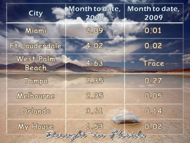
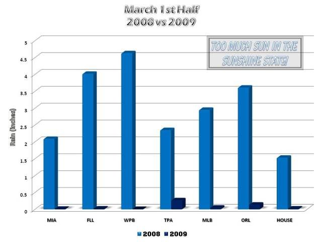
You know Florida is in a drought and any rain is noteworthy when the NWS Melbourne mentions the potential for a few hundredths of an inch of rain in isolated locations!

AREA FORECAST DISCUSSION
NATIONAL WEATHER SERVICE MELBOURNE FL
950 PM EDT SAT MAR 14 2009

.DISCUSSION...

CURRENT/OVERNIGHT...
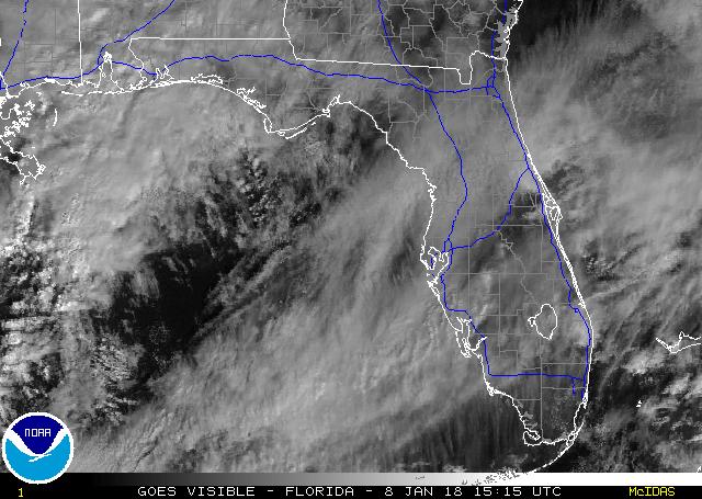
THOSE COLORS WITNESSED ON 88D RADAR THIS EVENING
ARE ACTUALLY LIGHT SHOWERS/SPRINKLES GENERATED FROM THE COLLISION OF
THE WEST AND EAST COAST SEA BREEZE BOUNDARIES. WHILE THIS IS NOT THE
FIRST COLLISION OF THESE BOUNDARIES THIS YEAR...IT IS THE FIRST TIME
CONVECTION HAS BEEN GENERATED AS A RESULT. MOST OF THIS ACTIVITY
WILL REMAIN LIGHT WITH A FEW AREAS PICKING UP A FEW HUNDREDTHS TO
POSSIBLY A TENTH OF PRECIPITATION
. CURRENTLY HANDLING THIS WITH A
NOWCAST AND EXPECT ACTIVITY TO FALL APART BY AROUND MIDNIGHT. SOME
ENHANCED CLOUD COVER IN THE VICINITY OF THE COLLISION...THOUGH
EXPECT MAINLY PARTLY CLOUDY SKIES MOST AREAS LATE TONIGHT INTO SUN
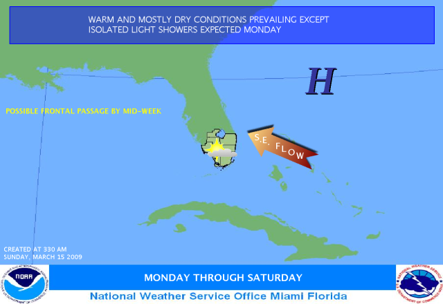
MORNING. LIGHT SOUTHEAST FLOW WILL CONTINUE TO VEER TO MORE
SOUTHERLY LATE TONIGHT. SOME PATCHY FOG POSSIBLE LATE AND EARLY SUN
MORNING...MAINLY INTERIOR PORTIONS OF EAST CENTRAL FLORIDA.

SUNDAY...(PREVIOUS)...SOUTHERLY WINDS WILL ALSO PULL A LITTLE MORE
MOISTURE NORTHWARD WITH PRECIPITABLE WATER VALUES RISING TO AROUND
AN INCH AND A QUARTER SUNDAY. HOWEVER...RAIN CHANCES REMAIN VERY LOW
AS THERE IS LITTLE MID AND UPPER LEVEL SUPPORT TO HELP TRIGGER
SHOWERS/STORMS AT THIS TIME
. SOUTHERLY FLOW WILL HELP PUSH AFTERNOON
HIGHS INTO THE UPPER 80S INTERIOR COUNTIES AND MID 80S ALONG THE
COAST WHERE A LATE SEA BREEZE MAY FORM TO LIMIT HEATING FROM CAPE
CANAVERAL/COCOA BEACH SOUTH.

&&


fact789 wrote:Pretty evident line of storms from Orlando south and north. I wish the summer pattern/sea breeze would start packing a punch.
0 likes   

User avatar
gatorcane
S2K Supporter
S2K Supporter
Posts: 23703
Age: 47
Joined: Sun Mar 13, 2005 3:54 pm
Location: Boca Raton, FL

Re: Florida Weather Thread: Dry weather pattern continues

#3985 Postby gatorcane » Sun Mar 15, 2009 10:01 am

Well despite the dry pattern Palm Beach County in South Florida is managing to squeeze out much needed rainfall as showers and good convergence exists with East windflow off the gulf stream. It's raining at my house right now:

NWS snippet

UPDATE...
THE ZONE FORECAST HAS BEEN UPDATED FOR THIS MORNING AND AFTERNOON.
GIVEN THE SOUTHEASTERLY FLOW AND DAY TIME HEATING SOME ISOLATED
SHOWERS HAVE STARTED ALONG THE COASTAL ZONE ALONG THE EAST COAST.
IN ADDITION THE LATEST GUIDANCE HAS INDICATED THAT SYNOPTIC SCALE LOW
LEVEL CONVERGENCE IS FAVORABLE IN THE ATLANTIC WATERS OFF THE PALM BEACH
COAST...WITH RECENT SATELLITE IMAGERY INDICATING THIS ALSO.


FOR THIS AFTERNOON...ASSUMING THE EAST COAST ISOLATED SHOWER
ACTIVITY WILL CONTINUE. WITH ADDITIONAL HEATING...SOME ISOLATED
LIGHT SHOWERS MAY POP UP ACROSS THE INTERIOR PENINSULA AS WELL.
BUT WITH OVERALL STABLE CONDITIONS...SHOWER ACTIVITY SHOWED BE
LIMITED AND LIGHT IN NATURE...EXCEPT FOR THE EASTERN COASTAL ZONE
WHERE MORE MODERATE SHOWERS ARE POSSIBLE.

The only place with rain in Florida is SE Florida (Palm Beach):

Image
0 likes   

jinftl
Category 5
Category 5
Posts: 4312
Joined: Tue Aug 31, 2004 4:47 pm
Location: fort lauderdale, fl

Re: Florida Weather Thread: Dry weather pattern continues

#3986 Postby jinftl » Sun Mar 15, 2009 10:38 am

How much rain have you gotten up by you so far? Nothing down here in Broward...partly cloudy skies...clearing up some from this morning when it was mostly cloudy. Can tell from the satellite pic as well that clouds are on the wane in Miami-Dade and Broward. Atmosphere is a bit too stable to support much in the way of rainfall development today.

Radar estimates show some areas have had a trace to 0.1" across south florida...but fairly scattered around...no concentrated area getting the bullseye of any high rain totals.

gatorcane wrote:Well despite the dry pattern Palm Beach County in South Florida is managing to squeeze out much needed rainfall as showers and good convergence exists with East windflow off the gulf stream. It's raining at my house right now:

NWS snippet

UPDATE...
THE ZONE FORECAST HAS BEEN UPDATED FOR THIS MORNING AND AFTERNOON.
GIVEN THE SOUTHEASTERLY FLOW AND DAY TIME HEATING SOME ISOLATED
SHOWERS HAVE STARTED ALONG THE COASTAL ZONE ALONG THE EAST COAST.
IN ADDITION THE LATEST GUIDANCE HAS INDICATED THAT SYNOPTIC SCALE LOW
LEVEL CONVERGENCE IS FAVORABLE IN THE ATLANTIC WATERS OFF THE PALM BEACH
COAST...WITH RECENT SATELLITE IMAGERY INDICATING THIS ALSO.


FOR THIS AFTERNOON...ASSUMING THE EAST COAST ISOLATED SHOWER
ACTIVITY WILL CONTINUE. WITH ADDITIONAL HEATING...SOME ISOLATED
LIGHT SHOWERS MAY POP UP ACROSS THE INTERIOR PENINSULA AS WELL.
BUT WITH OVERALL STABLE CONDITIONS...SHOWER ACTIVITY SHOWED BE
LIMITED AND LIGHT IN NATURE...EXCEPT FOR THE EASTERN COASTAL ZONE
WHERE MORE MODERATE SHOWERS ARE POSSIBLE.

The only place with rain in Florida is SE Florida (Palm Beach):

Image
0 likes   

Sanibel
Category 5
Category 5
Posts: 10385
Joined: Mon Aug 30, 2004 11:06 pm
Location: Offshore SW Florida

Re: Florida Weather Thread: Dry weather pattern continues

#3987 Postby Sanibel » Sun Mar 15, 2009 11:58 am

I like the way the visible satellite shows the turn of the Caribbean flow from SE to SW as it flows through the state.


79* - 69* Dew Point 65 That 69 is warm as a low.
0 likes   

jinftl
Category 5
Category 5
Posts: 4312
Joined: Tue Aug 31, 2004 4:47 pm
Location: fort lauderdale, fl

Re: Florida Weather Thread: Dry weather pattern continues

#3988 Postby jinftl » Sun Mar 15, 2009 2:58 pm

Only area getting rainfall is coincidentally enough the only area of the state not really needing it....the nw panhandle. Elsewhere, the latest kbdi report issued this afternoon shows continued deterioration of kbdi indices...in spite of some isolated sprinkles and showers over some areas yesterday and today.

Image

Counties with highest KBDI numbers as of 3/15/09 (in order, with change from last sunday in parentheses):

Hendry 736 (+9 from 3/8)
Highlands 733 (+9 from 3/8)
DeSoto 733 (+8 from 3/8)
Glades 730 (+8 from 3/8)
Palm Beach 725 (+10 from 3/8)
Sumter 714 (+14 from 3/8)
Martin 714 (+9 from 3/8)
Broward 706 (+11 from 3/8)
Okeechobee 702 (+11 from 3/8)
Miami-Dade 702 (+12 from 3/8)
http://flame.fl-dof.com/fire_weather/KBDI/4km_main.html
0 likes   

User avatar
HURAKAN
Professional-Met
Professional-Met
Posts: 46086
Age: 38
Joined: Thu May 20, 2004 4:34 pm
Location: Key West, FL
Contact:

#3989 Postby HURAKAN » Sun Mar 15, 2009 3:30 pm

Image

"SOUTHEAST FLOW WILL PREVAIL, KEEPING WARM AND MOSTLY DRY CONDITIONS ACROSS SOUTH FLORIDA. A COLD FRONT IS EXPECTED TO MOVE THROUGH THE AREA BY WEDNESDAY INCREASING THE CHANCES OF SHOWERS FOR THE END OF THE WEEK."

Link: http://www.srh.weather.gov/mfl/gcast/#

Not we want to see.
0 likes   

psyclone
S2K Supporter
S2K Supporter
Posts: 4802
Joined: Wed Aug 24, 2005 9:04 pm
Location: palm harbor fl

#3990 Postby psyclone » Sun Mar 15, 2009 3:31 pm

well the weather is just terrific but this drought is terrible... and getting worse. it's so bad trees are happy when my dog hikes his leg on them. And Hillsborough, Pasco and Pinellas residents could be facing the toughest water restrictions ever. A look at the US drought monitor shows severe drought expanding over central and south florida. Absent any meaningful rainfall (which appears unlikely), these two severe areas are likely to merge in coming weeks and maybe d3 (extreme) areas may show over southeast or west central portions of the peninsula.
0 likes   

User avatar
HURAKAN
Professional-Met
Professional-Met
Posts: 46086
Age: 38
Joined: Thu May 20, 2004 4:34 pm
Location: Key West, FL
Contact:

#3991 Postby HURAKAN » Sun Mar 15, 2009 10:57 pm

Image

Image

Last year we were also in a drought.
0 likes   

User avatar
boca
Category 5
Category 5
Posts: 6400
Age: 61
Joined: Mon Dec 15, 2003 8:49 am
Location: Boca Raton,FL

Re: Florida Weather Thread: Dry weather pattern continues

#3992 Postby boca » Mon Mar 16, 2009 12:27 am

Looks like another type of tropical system will be the way to help us out of this 2 to 3 year drought. This seems to be the case every year.
0 likes   

User avatar
tropicana
Category 5
Category 5
Posts: 8056
Joined: Sat Sep 27, 2003 6:48 pm
Location: Niagara Falls, Ontario, Canada
Contact:

Re: Florida Weather Thread: Dry weather pattern continues

#3993 Postby tropicana » Mon Mar 16, 2009 7:00 am

Sun Mar 15 2009

A 3rd day of 80 degree weather at Key West FL woooo! 81F recorded at 3:33pm.
Dry weather affecting mainland Florida also affecting Key West.
Just 0.03 inches of rain has fallen for the first 15 days of the month (compared to 0.98 inches for the same period in 2008).

-justin-
0 likes   

User avatar
Ivanhater
Storm2k Moderator
Storm2k Moderator
Posts: 11165
Age: 38
Joined: Fri Jul 01, 2005 8:25 am
Location: Pensacola

Re: Florida Weather Thread: Dry weather pattern continues

#3994 Postby Ivanhater » Mon Mar 16, 2009 7:23 am

Well we are getting heavy rain and thunderstorms and the Pensacola metro area is about 6 in below average, but the worst part of the state sadly isnt getting it
0 likes   

JonathanBelles
Professional-Met
Professional-Met
Posts: 11430
Age: 35
Joined: Sat Dec 24, 2005 9:00 pm
Location: School: Florida State University (Tallahassee, FL) Home: St. Petersburg, Florida
Contact:

#3995 Postby JonathanBelles » Mon Mar 16, 2009 7:40 am

I'm seafogged in here this morning. Fog has lifted some in the last hour, but not by much.
0 likes   

JonathanBelles
Professional-Met
Professional-Met
Posts: 11430
Age: 35
Joined: Sat Dec 24, 2005 9:00 pm
Location: School: Florida State University (Tallahassee, FL) Home: St. Petersburg, Florida
Contact:

#3996 Postby JonathanBelles » Mon Mar 16, 2009 7:58 am

Quite wet this morning as well. Dew is dripping off of the canopys.
0 likes   

User avatar
Tampa Bay Hurricane
Category 5
Category 5
Posts: 5598
Age: 37
Joined: Fri Jul 22, 2005 7:54 pm
Location: St. Petersburg, FL

#3997 Postby Tampa Bay Hurricane » Mon Mar 16, 2009 12:43 pm

Interior Florida may see some rain along the sea
breeze collision- across the bay there are some pretty
big popcorn clouds moving inland with the seabreeze...mainly
over western Hillsborough county it appears...

http://radar.weather.gov/ridge/radar.ph ... 1&loop=yes
Summer like showers just west of Orlando...
0 likes   

User avatar
HURAKAN
Professional-Met
Professional-Met
Posts: 46086
Age: 38
Joined: Thu May 20, 2004 4:34 pm
Location: Key West, FL
Contact:

Re: Florida Weather Thread: Dry weather pattern continues

#3998 Postby HURAKAN » Mon Mar 16, 2009 12:57 pm

Image

"A WEAK COLD FRONT WILL PASS SOUTHWARD ACROSS THE AREA LATE ON TUESDAY...BRINGING AN INCREASING CHANCE FOR MUCH-NEEDED RAINFALL. A STRONGER COLD FRONT IS EXPECTED AT THE END OF THE WEEK...ALLOWING A MUCH COOLER AND DRIER AIRMASS TO FILTER INTO THE REGION THIS WEEKEND."

Link: http://www.srh.noaa.gov/mfl/gcast/#

Some good news. NWS has 50% chance of precipitation for MIA on WED.
0 likes   

User avatar
HURAKAN
Professional-Met
Professional-Met
Posts: 46086
Age: 38
Joined: Thu May 20, 2004 4:34 pm
Location: Key West, FL
Contact:

#3999 Postby HURAKAN » Mon Mar 16, 2009 1:02 pm

According to the latest GFS, the precipitation totals won't be impressive but the front will hang on around SF.

Link: http://www.nco.ncep.noaa.gov/pmb/nwprod ... loop.shtml
0 likes   

jinftl
Category 5
Category 5
Posts: 4312
Joined: Tue Aug 31, 2004 4:47 pm
Location: fort lauderdale, fl

Re: Florida Weather Thread: Dry weather pattern continues

#4000 Postby jinftl » Mon Mar 16, 2009 5:12 pm

Update from NWS Miami this afternoon....slightly less bullish on rainfall totals mid-week.....but we'll take whatever we can get!

AS FAR AS QPF IS CONCERNED...HPC SHOWS AREAL AVG OF NEAR 0.5 INCH
EAST COAST WITH GENERALLY LESS THAN 0.25 INCH GULF COAST. LATEST
NAM LOOKS UNIMPRESSIVE WITH MOST AREAS NOT EVEN PICKING UP A
QUARTER INCH...SO THE VERDICT IS OUT ON WHETHER "REAL" BENEFICIAL
RAIN WILL OCCUR. THIS LOOKS LIKE A SITUATION WHERE MOST AREAS GET
A TENTH TO QUARTER INCH...WHILE SPOTTY LOCALES PICK UP AN INCH OR
SO
.

FCST SOUNDINGS SHOW A DECENT CAP TUE BUT THIS ERODES BY WED.
K-INDICES RISE TO NEAR 30 BY WED AFTERNOON AS H5 TEMPS REALLY COOL
OFF. SO IT IS NOT IMPOSSIBLE TO SEE THUNDERSTORMS HERE BY
WED...BUT DECIDED TO KEEP THIS OUT OF THE FCST AS THIS LOOKS LIKE
A VERY OUTSIDE SHOT NOW DUE TO WEAK CONVERGENCE...AND WE CAN ADD
THIS IN AS TIME APPROACHES IF THINGS LOOK MORE FAVORABLE.

LATE IN THE WEEK INTO NEXT WEEKEND...STRONGER HIGH PRESSURE BUILDS
NORTH OF THE AREA BEHIND A WEAKENING COLD FRONTAL BOUNDARY. THIS
WILL LEAD TO AN INCREASING NE WIND FLOW WITH AT LEAST ISOLATED
SHOWERS EXPECTED...FOCUSED ALONG THE ATLANTIC COAST. TEMPS WILL
FALL BY A FEW DEGREES...BUT NOTHING OF ANY CONSEQUENCE.
http://forecast.weather.gov/product.php ... glossary=1


Meanwhile, more central & south florida counties reach the 700 mark on today's KBDI....while the NW panhandle continues to get wetter.

13 counties now have average KBDI of 700 or higher...in order:

Hendry 737
DeSoto 734
Highlands 734
Glades 732
Palm Beach 726
Martin 716
Sumter 716
Broward 708
Miami-Dade 704
Okeechobee 704
Lake 703
Collier 700
Hardee 700


Image
0 likes   


Return to “USA & Caribbean Weather”

Who is online

Users browsing this forum: Cpv17, Stratton23 and 40 guests