Texas Summer 2018
Moderator: S2k Moderators
Forum rules

The posts in this forum are NOT official forecast and should not be used as such. They are just the opinion of the poster and may or may not be backed by sound meteorological data. They are NOT endorsed by any professional institution or STORM2K.
-
Clearcloudz

- Category 2

- Posts: 540
- Joined: Sun Jun 10, 2018 1:46 pm
- Location: Rosenberg TX
-
Clearcloudz
- Category 2
- Posts: 540
- Joined: Sun Jun 10, 2018 1:46 pm
- Location: Rosenberg TX

Re: Texas Summer 2018
FYI I read a news story were it says that storm systems are having a tendency to move much slower due to climate change (notice I did not put man made.. don't want to get involved in that) Weaker steering currents as well as increased precipitable water
1 likes
Re: Texas Summer 2018
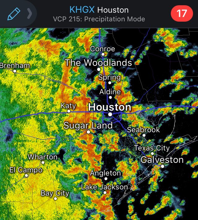
0.6" in the last 20 minutes or so, hearing loud cracks of thunder...this line is going to produce.
1 likes
-
Haris

- Category 5

- Posts: 1814
- Joined: Mon Nov 27, 2017 8:19 pm
- Location: ( Bee Cave) West Austin, Texas
Re: Texas Summer 2018
stop!!!!! you folks in houston are rubbing it in too much! i want rain here in central tx where ive seen a 1/2" only. GRRRRRRR 
4 likes
Weather geek and a storm spotter in West Austin. Not a degreed meteorologist. Big snow fan. Love rain and cold! Despise heat!
-
Clearcloudz
- Category 2
- Posts: 540
- Joined: Sun Jun 10, 2018 1:46 pm
- Location: Rosenberg TX
Re: Texas Summer 2018
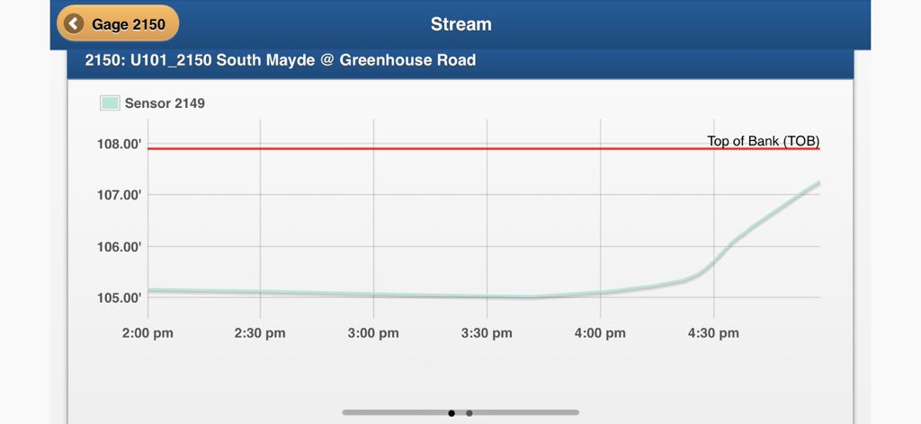
The bayou near my House just shot up. 2 inches in 30 minutes. Its still running buckets.

0 likes
Re: Texas Summer 2018
Haris wrote:stop!!!!! you folks in houston are rubbing it in too much! i want rain here in central tx where ive seen a 1/2" only. GRRRRRRR
basically nothing in Del Rio.. other than a quarter city storm for 10 minutes the other day.
0 likes
-
Clearcloudz
- Category 2
- Posts: 540
- Joined: Sun Jun 10, 2018 1:46 pm
- Location: Rosenberg TX
-
Clearcloudz
- Category 2
- Posts: 540
- Joined: Sun Jun 10, 2018 1:46 pm
- Location: Rosenberg TX
-
lrak

- S2K Supporter

- Posts: 1770
- Age: 59
- Joined: Thu Jun 21, 2007 2:48 pm
- Location: Corpus Christi, TX
Re: Texas Summer 2018
I haven't seen a white color in S. TX for accumulation in a while. The Valley is getting soaked beyond belief and a lot of folks are not protected with good shelter or high ground. Head towards the island if you can and take a day off. Like that forecaster said "very very very very very" bad.
https://radar.weather.gov/radar.php?rid ... 11&loop=no
https://radar.weather.gov/radar.php?rid ... 11&loop=no
1 likes
AKA karl
Also
Personal Forecast Disclaimer:
My posts on this forum are NOT official forecast and should not be used as such. My posts are my basic observations and are definitely not backed by any "well some" meteorological knowledge. For official information, please refer to the NHC and NWS products.
Also
Personal Forecast Disclaimer:
My posts on this forum are NOT official forecast and should not be used as such. My posts are my basic observations and are definitely not backed by any "well some" meteorological knowledge. For official information, please refer to the NHC and NWS products.

Re: Texas Summer 2018
My Davis station recorded a peak of 5.54" per hour around 530 in the Spring area, just south of the Woodlands. 1.72" total for the day and 4.66" for past three days. I'll take this any day compared to the 26" I recorded here for Harvey.
1 likes
TW in Texas Hill Country 
-
Brent
- S2K Supporter
- Posts: 38741
- Age: 37
- Joined: Sun May 16, 2004 10:30 pm
- Location: Tulsa Oklahoma
- Contact:
Re: Texas Summer 2018
Haris wrote:stop!!!!! you folks in houston are rubbing it in too much! i want rain here in central tx where ive seen a 1/2" only. GRRRRRRR
I know right... first Harvey now this

1 likes
#neversummer


Re: Texas Summer 2018
hriverajr wrote:FYI I read a news story were it says that storm systems are having a tendency to move much slower due to climate change (notice I did not put man made.. don't want to get involved in that) Weaker steering currents as well as increased precipitable water
It's no doubt that while we are not breaking much cold records...the maximum rainfall records have fallen quite frequently the past decade at various stations. Warmer air holds more water.
2 likes
The above post and any post by Ntxw is NOT an official forecast and should not be used as such. It is just the opinion of the poster and may or may not be backed by sound meteorological data. It is NOT endorsed by any professional institution including Storm2k. For official information, please refer to NWS products.
Help support Storm2K!
-
Rgv20

- S2K Supporter
- Posts: 2466
- Age: 39
- Joined: Wed Jan 05, 2011 5:42 pm
- Location: Edinburg/McAllen Tx
Re: Texas Summer 2018
Damn Radar is starting to light up again...

MESOSCALE PRECIPITATION DISCUSSION 0341
NWS WEATHER PREDICTION CENTER COLLEGE PARK MD
804 PM EDT WED JUN 20 2018
AREAS AFFECTED...SOUTH TEXAS
CONCERNING...HEAVY RAINFALL...FLASH FLOODING POSSIBLE
VALID 210003Z - 210603Z
SUMMARY...CONVECTION HAS ENHANCED EARLY THIS EVENING ON THE
EASTERN SIDE OF THE STATIONARY UPPER VORT OVER SOUTH TEXAS. SLOW
MOVEMENT AND TRAINING OF CELLS POSSIBLE INTO THIS EVENING.
DISCUSSION...LITTLE MOVEMENT EXPECTED TO THE MCV OVER FAR SOUTH
TEXAS THIS EVENING. CONVECTION HAS BEGUN TO ENHANCE ON THE EASTERN
AND SOUTHEASTERN SIDE OF THIS MCV IN THE PERSISTENT AXIS OF MUCH
ABOVE AVERAGE PW VALUES...2.5 TO 3 STANDARD DEVIATIONS ABOVE THE
MEAN. AT THE MOMENT...THE STRONGEST CONVECTION IS ON THE EASTERN
AND SOUTHEASTERN SIDE OF THIS NEARLY STATIONARY VORT ALONG THE
SOUTH TEXAS COAST. THIS IS ON THE WESTERN EDGE OF THE AXIS OF
VERY UNSTABLE AIR SITUATED JUST OFFSHORE...MUCAPE VALUES IN THE
2000-3000+ RANGE. WITH NO SIGNIFICANT MOVEMENT TO THIS MCV AND
PERSISTENT SOUTH SOUTHEASTERLY INFLOW OF VERY UNSTABLE AIR
OFFSHORE...EXPECT THE POTENTIAL FOR SLOW MOVING AND TRAINING OF
CELLS TO CONTINUE INTO THIS EVENING...ESPECIALLY ON THE EASTERN
SIDE OF THIS MCV ACROSS COASTAL SOUTH TEXAS.
SIMULATED RADARS FROM THE HRRX SHOW THIS TRAINING CONTINUING THRU
THIS EVENING INTO THE EARLY HOURS OF THURSDAY. THE HRRR
HOWEVER...HAS A SHORTER PERIOD OF TRAINING AND ATTEMPTS TO DEVELOP
HEAVY PRECIP FARTHER INLAND ACROSS THE LOWER RIO GRANDE VALLEY IN
LIEU OF COASTAL ACTIVITY. THE HRRX ALSO SHOWS THE INLAND ACTIVITY
BUT MAINTAINS THE TRAINING THREAT ALONG THE COAST. GIVEN THE
HISTORY OF TRAINING WITH THIS SYSTEM ALONG THE TX COAST AND THE
EXPECTED SLOW MOVEMENT OF THE MCV...BELIEVE THE HRRRX MAY HAVE A
BETTER HANDLE ON THE FLASH FLOOD POTENTIAL GOING INTO THIS EVENING
AND OVERNIGHT.
ORAVEC
ATTN...WFO...BRO...CRP...
ATTN...RFC...WGRFC...
LAT...LON 28149783 27279643 25069699 25599920 26439962
27659907
0 likes
The following post is NOT an official forecast and should not be used as such. It is just the opinion of the poster and may or may not be backed by sound meteorological data. It is NOT endorsed by any professional institution including storm2k.org For Official Information please refer to the NHC and NWS products.
-
bubba hotep

- S2K Supporter
- Posts: 6014
- Joined: Wed Dec 28, 2016 1:00 am
- Location: Collin County Texas
Re: Texas Summer 2018
Go Storms Go!

1 likes
Winter time post are almost exclusively focused on the DFW area.
-
Brent
- S2K Supporter
- Posts: 38741
- Age: 37
- Joined: Sun May 16, 2004 10:30 pm
- Location: Tulsa Oklahoma
- Contact:
Re: Texas Summer 2018
bubba hotep wrote:Go Storms Go!
West of me... but maybe the big airport will get something for once.
0 likes
#neversummer
-
bubba hotep
- S2K Supporter
- Posts: 6014
- Joined: Wed Dec 28, 2016 1:00 am
- Location: Collin County Texas
Re: Texas Summer 2018
Brent wrote:bubba hotep wrote:Go Storms Go!
West of me... but maybe the big airport will get something for once.
Yea, was pretty bummed with how hard west they have been building but it does look like the airport might pick it up.
0 likes
Winter time post are almost exclusively focused on the DFW area.
-
bubba hotep
- S2K Supporter
- Posts: 6014
- Joined: Wed Dec 28, 2016 1:00 am
- Location: Collin County Texas
Re: Texas Summer 2018
Watching the cell in Fannin County, it looks like it might try to move westward into Collin County. There might be an outflow boundary for it to ride?

0 likes
Winter time post are almost exclusively focused on the DFW area.
-
TheProfessor

- Professional-Met

- Posts: 3506
- Age: 29
- Joined: Tue Dec 03, 2013 10:56 am
- Location: Wichita, Kansas
Re: Texas Summer 2018
Wow, it's really coming down here.
1 likes
An alumnus of The Ohio State University.
Your local National Weather Service office is your best source for weather information.
Your local National Weather Service office is your best source for weather information.

Re: Texas Summer 2018
Beautiful purple lighting as I was driving home from the Colony to Frisco. The deer were all out of the woods! 
4 likes
Graduate Meteorology Student at the University of Oklahoma!
All opinions independent of employers and the university.
All opinions independent of employers and the university.
Return to “USA & Caribbean Weather”
Who is online
Users browsing this forum: No registered users and 40 guests