SE TX/SW LA weather: Much cooler and WET after Tuesday

U.S. & Caribbean Weather Discussions and Severe Weather Events

Moderator: S2k Moderators

Forum rules

The posts in this forum are NOT official forecast and should not be used as such. They are just the opinion of the poster and may or may not be backed by sound meteorological data. They are NOT endorsed by any professional institution or STORM2K.

Help Support Storm2K
Message
Author
User avatar
srainhoutx
S2K Supporter
S2K Supporter
Posts: 6919
Age: 67
Joined: Sun Jan 14, 2007 11:34 am
Location: Haywood County, NC
Contact:

Re: SE TX/SW LA weather: Excessive rainfall Thursday-FF Watch

#4221 Postby srainhoutx » Thu Oct 29, 2009 1:18 pm

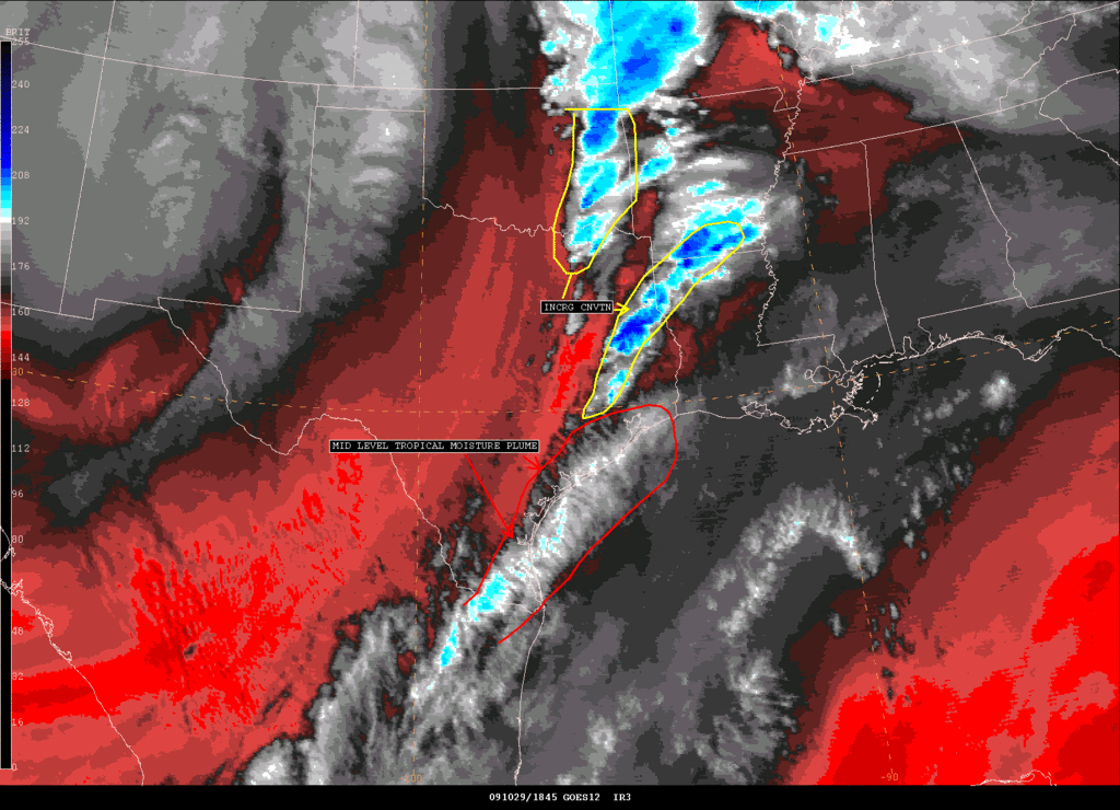
vbhoutex wrote:We have been getting the same here Steve without the thunder. I just heard it in the distance though as I was finishing this post. Have picked up a quick .25" in the last 45 minutes. What Jeff states is what I am seeing happening in real time here as we have had training showers for the last hour minimum. Not liking the trend at all, especially if the worst is to come tonight.


Yeah David it is concerning. Tornado Watch up now for all but the Coastal Counties..

Image

WOUS64 KWNS 291811
WOU2

BULLETIN - IMMEDIATE BROADCAST REQUESTED
TORNADO WATCH OUTLINE UPDATE FOR WT 782
NWS STORM PREDICTION CENTER NORMAN OK
115 PM CDT THU OCT 29 2009

TORNADO WATCH 782 IS IN EFFECT UNTIL 900 PM CDT FOR THE
FOLLOWING LOCATIONS

ARC027-057-061-073-081-091-099-133-139-300200-
/O.NEW.KWNS.TO.A.0782.091029T1815Z-091030T0200Z/

AR
. ARKANSAS COUNTIES INCLUDED ARE

COLUMBIA HEMPSTEAD HOWARD
LAFAYETTE LITTLE RIVER MILLER
NEVADA SEVIER UNION


LAC011-013-015-017-021-027-031-043-049-059-061-069-073-081-085-
111-115-119-127-300200-
/O.NEW.KWNS.TO.A.0782.091029T1815Z-091030T0200Z/

LA
. LOUISIANA PARISHES INCLUDED ARE

BEAUREGARD BIENVILLE BOSSIER
CADDO CALDWELL CLAIBORNE
DE SOTO GRANT JACKSON
LA SALLE LINCOLN NATCHITOCHES
OUACHITA RED RIVER SABINE
UNION VERNON WEBSTER
WINN


TXC005-037-041-051-067-185-199-201-203-225-241-291-313-315-339-
347-351-365-373-401-403-405-407-419-455-457-471-473-477-
300200-
/O.NEW.KWNS.TO.A.0782.091029T1815Z-091030T0200Z/

TX
. TEXAS COUNTIES INCLUDED ARE

ANGELINA BOWIE BRAZOS
BURLESON CASS GRIMES
HARDIN HARRIS HARRISON
HOUSTON JASPER LIBERTY
MADISON MARION MONTGOMERY
NACOGDOCHES NEWTON PANOLA
POLK RUSK SABINE
SAN AUGUSTINE SAN JACINTO SHELBY
TRINITY TYLER WALKER
WALLER WASHINGTON


ATTN...WFO...SHV...HGX...LCH...
0 likes   
Carla/Alicia/Jerry(In The Eye)/Michelle/Charley/Ivan/Dennis/Katrina/Rita/Wilma/Ike/Harvey

Member: National Weather Association
Wx Infinity Forums
http://wxinfinity.com/index.php

Facebook.com/WeatherInfinity
Twitter @WeatherInfinity

User avatar
srainhoutx
S2K Supporter
S2K Supporter
Posts: 6919
Age: 67
Joined: Sun Jan 14, 2007 11:34 am
Location: Haywood County, NC
Contact:

Re: SE TX/SW LA weather: Excessive rainfall Thursday-FF Watch

#4222 Postby srainhoutx » Thu Oct 29, 2009 1:49 pm

another e-mail from Jeff...

SPC has issued a Tornado Watch until 900pm for a large part of SE TX mainly along and N of I-10.


Strong mid level cooling approaching EC and SE TX from the west will remove remaining mid level capping within the next 1-2 hours. Significant increase in convection is expected along low level speed convergent boundary along US 59 corridor and northward this afternoon and evening. Low level shear is on the order of 400 M^s/S^2 providing favorable low level rotation. Cell over Walker County in the last hour has shown some rotation.


Given slightly more heating and mid level cooling should see storms increase.


Additionally, excessive rainfall appears to be focusing along and just W of I-45 at the moment as low level speed convergence has become established. Angleton has SE sustained at near 27kts with Pearland and Sugarland are near 20kts resulting in low level winds piling along US 59 creating lift and numerous storms. Storms are developing over the same region of Wharton, Fort Bend, and Harris counties and then training NNE across Harris into Montgomery and San Jacinto counties. Close watch will be needed for flooding this afternoon along this corridor.
0 likes   
Carla/Alicia/Jerry(In The Eye)/Michelle/Charley/Ivan/Dennis/Katrina/Rita/Wilma/Ike/Harvey

Member: National Weather Association
Wx Infinity Forums
http://wxinfinity.com/index.php

Facebook.com/WeatherInfinity
Twitter @WeatherInfinity

User avatar
vbhoutex
Storm2k Executive
Storm2k Executive
Posts: 29113
Age: 73
Joined: Wed Oct 09, 2002 11:31 pm
Location: Cypress, TX
Contact:

Re: SE TX/SW LA weather: Excessive rainfall Thursday-FF Watch

#4223 Postby vbhoutex » Thu Oct 29, 2009 2:00 pm

I can once again confirm what Jeff has said. We are still getting pounded on and off(more on) here in Spring Branch. We have had some minor short lasting street flooding. We are now over an inch of rain since 8:30am and at least 0.60" of it has come in the last 45 minutes. Each time I try to leave to do some errands, it starts pouring again. The errands may not happen today, but the rains most definitely are here and don't seem to be going anywhere to fast unless you are following then NNE. :rain:
0 likes   
Skywarn, C.E.R.T.
Please click below to donate to STORM2K to help with the expenses of keeping the site going:
Image

User avatar
Ptarmigan
Category 5
Category 5
Posts: 5313
Joined: Wed Aug 16, 2006 9:06 pm

Re: SE TX/SW LA weather: Excessive rainfall Thursday-FF Watch

#4224 Postby Ptarmigan » Thu Oct 29, 2009 2:03 pm

It's beening raining off an on.
0 likes   

User avatar
srainhoutx
S2K Supporter
S2K Supporter
Posts: 6919
Age: 67
Joined: Sun Jan 14, 2007 11:34 am
Location: Haywood County, NC
Contact:

Re: SE TX/SW LA weather: Excessive rainfall Thursday-FF Watch

#4225 Postby srainhoutx » Thu Oct 29, 2009 2:10 pm

We've got thunder again and very gusty winds.
0 likes   
Carla/Alicia/Jerry(In The Eye)/Michelle/Charley/Ivan/Dennis/Katrina/Rita/Wilma/Ike/Harvey

Member: National Weather Association
Wx Infinity Forums
http://wxinfinity.com/index.php

Facebook.com/WeatherInfinity
Twitter @WeatherInfinity

User avatar
srainhoutx
S2K Supporter
S2K Supporter
Posts: 6919
Age: 67
Joined: Sun Jan 14, 2007 11:34 am
Location: Haywood County, NC
Contact:

Re: SE TX/SW LA weather: Excessive rainfall Thursday-FF Watch

#4226 Postby srainhoutx » Thu Oct 29, 2009 2:40 pm

SATELLITE PRECIPITATION ESTIMATES..DATE/TIME 10/29/09 1921Z
SATELLITE ANALYSIS BRANCH/NESDIS---NPPU---TEL.301-763-8678
LATEST DATA USED: G12 1900Z
.
LOCATION...NW LOUISIANA...S ARKANSAS...TEXAS...
.
ATTN WFOS...JAN...LZK...LCH...SHV...HGX...
ATTN RFCS...LMRFC...WGRFC...
.
EVENT...INCRG BANDS OF SW-NW CNVTN
.
SATELLITE ANALYSIS AND TRENDS...SW-NE ORIENTED BANDS OF CNVTN HAVE BEEN
INCRG ACRS AN AREA FM W OF GALVESTON BAY THRU S AR. THESE STMS ARE ALIGNED
WITH THETA-E RIDGES AT SFC AND 850MB..AND ARE BEING FUELED BY LL AND UPPR
JETS. WV IMAGERY ANIMATION SHOWS TROPICAL PW PLUME BEGINNING TO CROSS THE
SE AND UPPR TX COAST..WHICH SHOULD HELP TO FURTHER MOISTEN THE ATMOSPHERE
(ESP AT MID LEVELS) AND LEAD TO FURTHER INCR IN CONVECTIVE COVERAGE AND
INTENSITY. ATTM THE COLDEST TOPS EXTEND FM SW OF LFK/TX TO NW LA AND
FM SW TO E AND NE OF ELD/AR. INDIVIDUAL STMS ARE MOVG NEWD..BUT WITH
EXPECTED INCR IN COVERAGE THE LIKELIHOOD OF SOME CELL TRAINING..AS WELL
AS MERGERS..WILL INCR ACS THE DISCUSSION AREA. BLENDED TPW STLT IMAGERY
SHOWS PWS RANGING UP TO 2"PLUS OVER PARTS OF THE AREA...OVER 200 PER
CENT OF NORMAL. BASED ON TRENDS..AND COPIOUS MOISTURE..WOULD EXPECT HRLY
AMOUNTS BTWN 1-2"..WITH 2"PLUS IN AN HR WHERE MERGERS OCCUR.

Image
0 likes   
Carla/Alicia/Jerry(In The Eye)/Michelle/Charley/Ivan/Dennis/Katrina/Rita/Wilma/Ike/Harvey

Member: National Weather Association
Wx Infinity Forums
http://wxinfinity.com/index.php

Facebook.com/WeatherInfinity
Twitter @WeatherInfinity

User avatar
srainhoutx
S2K Supporter
S2K Supporter
Posts: 6919
Age: 67
Joined: Sun Jan 14, 2007 11:34 am
Location: Haywood County, NC
Contact:

Re: SE TX/SW LA weather: Excessive rainfall Thursday-FF Watch

#4227 Postby srainhoutx » Thu Oct 29, 2009 3:07 pm

Image

MESOSCALE DISCUSSION 2158
NWS STORM PREDICTION CENTER NORMAN OK
0303 PM CDT THU OCT 29 2009

AREAS AFFECTED...SRN AR/E TX/WRN LA

CONCERNING...TORNADO WATCH 782...783...

VALID 292003Z - 292200Z

THE SEVERE WEATHER THREAT FOR TORNADO WATCH 782...783...CONTINUES.

WIDESPREAD SHOWERS AND THUNDERSTORMS -- WITH EMBEDDED
STRONGER/ROTATING CELLS -- CONTINUE ACROSS WW 782 AND 783...AHEAD OF
THE SLOWLY ADVANCING SURFACE COLD FRONT. A MOIST/UNSTABLE WARM
SECTOR PERSISTS ACROSS THIS REGION...BENEATH STRONG/UNIDIRECTIONAL
SSWLY FLOW ALOFT. WITH BOUNDARY-LAYER SSELYS VEERING SLIGHTLY AND
INCREASING TO SLY AT 1/2 TO 1 KM AGL...SHEAR THROUGH THIS LAYER
REMAINS SUPPORTIVE OF LOW-LEVEL ROTATION WITH SUSTAINED CELLS -- AND
ASSOCIATED/ISOLATED TORNADO THREAT. IN ADDITION...INDIVIDUAL CELLS
MOVING QUICKLY NNEWD CONTINUE TO REVEAL OCCASIONAL BOWING
STRUCTURES...SUGGESTIVE OF ISOLATED DAMAGING WIND POTENTIAL.

..GOSS.. 10/29/2009


ATTN...WFO...JAN...LZK...LCH...SHV...TSA...HGX...FWD...
0 likes   
Carla/Alicia/Jerry(In The Eye)/Michelle/Charley/Ivan/Dennis/Katrina/Rita/Wilma/Ike/Harvey

Member: National Weather Association
Wx Infinity Forums
http://wxinfinity.com/index.php

Facebook.com/WeatherInfinity
Twitter @WeatherInfinity

User avatar
JenBayles
Category 5
Category 5
Posts: 3461
Age: 62
Joined: Tue Aug 26, 2003 3:27 pm
Location: Houston, TX
Contact:

#4228 Postby JenBayles » Thu Oct 29, 2009 3:52 pm

One of the weirder weather days I've experienced. Still getting peeks of sun in between showers here in Bear Creek. So far we've escaped the really heavy downpours. I had a doc appointment at 290 and Huffmeister and drove in and out of some pretty heavy rain.

Got home to see my mom had come for a visit because she lost power in Glencairn. shortly after, we lost power for a few minutes and Centerpoint says 5,000 are out right now. Just came on here, and I REALLY hope it's back on at Mom's. She has panic attacks without electricity and is on her way to a doozy. She's about ready for another blood transfusion and I'm taking her in for a check tomorrow morning - that is, if I'm not flooded in here. That's another panic attack for mom that started this morning - finding someone to get her to the doctor if I can't get out. <sigh>

David, I'm praying you get out of the bullseye by tonight! No doubt we all have a long night ahead of us.
0 likes   

User avatar
Diva
S2K Supporter
S2K Supporter
Posts: 205
Joined: Fri Jun 16, 2006 11:46 am
Location: Orange, TX

#4229 Postby Diva » Thu Oct 29, 2009 3:57 pm

Good grief...this wind is unreal! Just ran out to pickup kids from school and my little SUV was getting blown all over the place! I would hate to be driving a high profile vehicle (i.e. 18 wheeler) on the Rainbow Bridge right now. :eek:
Still no rain here so I'm hoping we will catch a break from the training and just get brief showers as the front moves through.
0 likes   

User avatar
southerngale
Retired Staff
Retired Staff
Posts: 27418
Joined: Thu Oct 10, 2002 1:27 am
Location: Southeast Texas (Beaumont area)

#4230 Postby southerngale » Thu Oct 29, 2009 4:01 pm

I got some pretty hard rain this morning, but it didn't last very long. Not much on radar around here, either... it's all west or north of us. With a 100% chance of showers and thunderstorms, some possibly severe, it looks like a bust for this area, at least today. Still have 100% chance for tonight and tomorrow. It's very windy, though and there's widespread power outages, presumably from the wind.

For those who get the heavy storms, stay safe!
0 likes   
Please support Storm2k by making a donation today. It is greatly appreciated! Click here: Image

Image my Cowboys Image my RocketsImage my Astros

User avatar
JenBayles
Category 5
Category 5
Posts: 3461
Age: 62
Joined: Tue Aug 26, 2003 3:27 pm
Location: Houston, TX
Contact:

#4231 Postby JenBayles » Thu Oct 29, 2009 4:13 pm

Anyone out in Katy? Seems like that line of storms has been training there - or just west - for a couple of hours.
0 likes   

User avatar
srainhoutx
S2K Supporter
S2K Supporter
Posts: 6919
Age: 67
Joined: Sun Jan 14, 2007 11:34 am
Location: Haywood County, NC
Contact:

Re: SE TX/SW LA weather: Excessive rainfall Thursday-FF Watch

#4232 Postby srainhoutx » Thu Oct 29, 2009 4:19 pm

Most of the heaviest rain has been just to my W today. Harris County Rain Gauges show that Spring Creek and Little Cypress Creek (NW Harris County) have had almost 2 inches so far. I've had about an inch.

FYI: Tornado on the ground in Shreveport at this time.
0 likes   
Carla/Alicia/Jerry(In The Eye)/Michelle/Charley/Ivan/Dennis/Katrina/Rita/Wilma/Ike/Harvey

Member: National Weather Association
Wx Infinity Forums
http://wxinfinity.com/index.php

Facebook.com/WeatherInfinity
Twitter @WeatherInfinity

User avatar
TexasSam
Category 2
Category 2
Posts: 573
Age: 66
Joined: Thu Aug 28, 2003 12:16 am
Location: Port Arthur, Texas

Re: SE TX/SW LA weather: Excessive rainfall Thursday-FF Watch

#4233 Postby TexasSam » Thu Oct 29, 2009 4:47 pm

BULLETIN - EAS ACTIVATION REQUESTED
TORNADO WARNING
NATIONAL WEATHER SERVICE HOUSTON/GALVESTON TX
443 PM CDT THU OCT 29 2009

THE NATIONAL WEATHER SERVICE IN LEAGUE CITY HAS ISSUED A

* TORNADO WARNING FOR...
MONTGOMERY COUNTY IN SOUTHEAST TEXAS...

* UNTIL 515 PM CDT

* AT 436 PM CDT...NATIONAL WEATHER SERVICE DOPPLER RADAR INDICATED
A SEVERE THUNDERSTORM CAPABLE OF PRODUCING A TORNADO. THIS TORNADO
WAS LOCATED 10 MILES SOUTH OF MONTGOMERY...MOVING NORTHEAST AT
40 MPH.

* LOCATIONS IN THE TORNADO WARNING INCLUDE BUT ARE NOT LIMITED TO
LAKE CONROE DAM...WILLIS AND PANORAMA VILLAGE.
0 likes   

User avatar
JenBayles
Category 5
Category 5
Posts: 3461
Age: 62
Joined: Tue Aug 26, 2003 3:27 pm
Location: Houston, TX
Contact:

#4234 Postby JenBayles » Thu Oct 29, 2009 4:51 pm

These downpours aren't our typical tropical p*ss downs with drops the size of 50-cent pieces. Just had one here and the drops were so small you couldn't hear them on the roof, but so thick it looked like heavy fog. Bizzare.

Here's a link to the USGS gauge data for Langham Creek at West Little York - our particular offender in this neck of the woods. It shows graphs of discharge rates (cfs), gauge height and precip for the past month. I'm glad to see it's back to more or less usual rates since the rise a few days ago. With already saturated ground, it will no doubt rise quickly once the rains really get going.

http://waterdata.usgs.gov/usa/nwis/uv?site_no=08072760

Here's the USGS map of Texas where you can access all the other gauge sites:

http://waterdata.usgs.gov/tx/nwis/rt/tx
0 likes   

User avatar
vbhoutex
Storm2k Executive
Storm2k Executive
Posts: 29113
Age: 73
Joined: Wed Oct 09, 2002 11:31 pm
Location: Cypress, TX
Contact:

Re: SE TX/SW LA weather: Excessive rainfall Thursday-FF Watch

#4235 Postby vbhoutex » Thu Oct 29, 2009 5:00 pm

Like you said Jen it has just been weird today.We just went through another round of downpours here. I think you are on the west side of the train and I am under it or slightly East of it. We are now up to 1.45" for the day. I figured I better empty the gauge since tonight could be a doozy. Definitely gonna sleep(if I do)with one eye on the radar and an ear open for noises I'm not used to. It has really been strange having these sneak peeks of sunshine in between torrential downpours. More as/if it develops.
Another glance at the radar makes me think we have a line setting up just West of Harris County that may take its' sweet time moving West to East across the metro area later this evening. It already has set up the training. :grr: :grr:
0 likes   
Skywarn, C.E.R.T.
Please click below to donate to STORM2K to help with the expenses of keeping the site going:
Image

User avatar
srainhoutx
S2K Supporter
S2K Supporter
Posts: 6919
Age: 67
Joined: Sun Jan 14, 2007 11:34 am
Location: Haywood County, NC
Contact:

Re: SE TX/SW LA weather: Excessive rainfall Thursday-FF Watch

#4236 Postby srainhoutx » Thu Oct 29, 2009 5:07 pm

TORNADO WARNING
TXC339-407-471-292230-
/O.NEW.KHGX.TO.W.0043.091029T2204Z-091029T2230Z/

BULLETIN - EAS ACTIVATION REQUESTED
TORNADO WARNING
NATIONAL WEATHER SERVICE HOUSTON/GALVESTON TX
504 PM CDT THU OCT 29 2009

THE NATIONAL WEATHER SERVICE IN LEAGUE CITY HAS ISSUED A

* TORNADO WARNING FOR...
NORTHERN MONTGOMERY COUNTY IN SOUTHEAST TEXAS...
NORTHWESTERN SAN JACINTO COUNTY IN SOUTHEAST TEXAS...
EASTERN WALKER COUNTY IN SOUTHEAST TEXAS...

* UNTIL 530 PM CDT

* AT 459 PM CDT...NATIONAL WEATHER SERVICE DOPPLER RADAR INDICATED A
SEVERE THUNDERSTORM CAPABLE OF PRODUCING A TORNADO. THIS TORNADO
WAS LOCATED 7 MILES SOUTHWEST OF NEW WAVERLY...MOVING NORTHEAST AT
50 MPH.

* LOCATIONS IN THE TORNADO WARNING INCLUDE BUT ARE NOT LIMITED TO
HUNTSVILLE STATE PARK...NEW WAVERLY...AND OAKHURST.
0 likes   
Carla/Alicia/Jerry(In The Eye)/Michelle/Charley/Ivan/Dennis/Katrina/Rita/Wilma/Ike/Harvey

Member: National Weather Association
Wx Infinity Forums
http://wxinfinity.com/index.php

Facebook.com/WeatherInfinity
Twitter @WeatherInfinity

User avatar
srainhoutx
S2K Supporter
S2K Supporter
Posts: 6919
Age: 67
Joined: Sun Jan 14, 2007 11:34 am
Location: Haywood County, NC
Contact:

Re: SE TX/SW LA weather: Excessive rainfall Thursday-FF Watch

#4237 Postby srainhoutx » Thu Oct 29, 2009 5:10 pm

Code: Select all

Current Weather Conditions:
COLLEGE STN EASTERWOOD FIELD, TX, United States 
(KCLL) 30-35N 096-22W 96M 

--------------------------------------------------------------------------------
 
Conditions at  Oct 29, 2009 - 06:04 PM EDTOct 29, 2009 - 05:04 PM CDTOct 29, 2009 - 04:04 PM MDTOct 29, 2009 - 03:04 PM PDTOct 29, 2009 - 02:04 PM ADTOct 29, 2009 - 01:04 PM HDT
2009.10.29 2204 UTC 
Wind  from the NW (310 degrees) at 18 MPH (16 KT) gusting to 30 MPH (26 KT) 
Visibility  9 mile(s) 
Sky conditions  overcast 
Weather  Light rain 
Precipitation last hour  0.01 inches 
Temperature  66 F (19 C) 
Dew Point  57 F (14 C) 
Relative Humidity  72% 
Pressure (altimeter)  29.64 in. Hg (1003 hPa) 
0 likes   
Carla/Alicia/Jerry(In The Eye)/Michelle/Charley/Ivan/Dennis/Katrina/Rita/Wilma/Ike/Harvey

Member: National Weather Association
Wx Infinity Forums
http://wxinfinity.com/index.php

Facebook.com/WeatherInfinity
Twitter @WeatherInfinity

User avatar
JenBayles
Category 5
Category 5
Posts: 3461
Age: 62
Joined: Tue Aug 26, 2003 3:27 pm
Location: Houston, TX
Contact:

Re: SE TX/SW LA weather: Excessive rainfall Thursday-FF Watch

#4238 Postby JenBayles » Thu Oct 29, 2009 5:40 pm

vbhoutex wrote:Like you said Jen it has just been weird today.We just went through another round of downpours here. I think you are on the west side of the train and I am under it or slightly East of it. We are now up to 1.45" for the day. I figured I better empty the gauge since tonight could be a doozy. Definitely gonna sleep(if I do)with one eye on the radar and an ear open for noises I'm not used to. It has really been strange having these sneak peeks of sunshine in between torrential downpours. More as/if it develops.
Another glance at the radar makes me think we have a line setting up just West of Harris County that may take its' sweet time moving West to East across the metro area later this evening. It already has set up the training. :grr: :grr:


Check out the train tracks from Matagorda Bay through Ft. Bend, Waller and a smidge of far west Harris County and points NNE. Definitely got its act together now and no westward movement that I can detect. The line only seems to be getting wider and solidifying right now.

Looks like you've got a bit of a break right now David. Hope it holds off a while for you. We can take about 30 minutes of 1.5" / hour rain here before the street floods and is impassable for hours. After that, all bets are off. How about your street?
0 likes   

User avatar
srainhoutx
S2K Supporter
S2K Supporter
Posts: 6919
Age: 67
Joined: Sun Jan 14, 2007 11:34 am
Location: Haywood County, NC
Contact:

Re: SE TX/SW LA weather: Excessive rainfall Thursday-FF Watch

#4239 Postby srainhoutx » Thu Oct 29, 2009 6:03 pm

Yikes...

FLASH FLOOD WARNING
TXC185-201-339-471-473-300200-
/O.NEW.KHGX.FF.W.0040.091029T2257Z-091030T0200Z/
/00000.0.ER.000000T0000Z.000000T0000Z.000000T0000Z.OO/

BULLETIN - EAS ACTIVATION REQUESTED
FLASH FLOOD WARNING
NATIONAL WEATHER SERVICE HOUSTON/GALVESTON TX
557 PM CDT THU OCT 29 2009

THE NATIONAL WEATHER SERVICE IN LEAGUE CITY HAS ISSUED A

* FLASH FLOOD WARNING FOR...
SOUTHEASTERN GRIMES COUNTY IN SOUTHEAST TEXAS...
NORTHWESTERN HARRIS COUNTY IN SOUTHEAST TEXAS...
WESTERN MONTGOMERY COUNTY IN SOUTHEAST TEXAS...
SOUTHERN WALKER COUNTY IN SOUTHEAST TEXAS...
EASTERN WALLER COUNTY IN SOUTHEAST TEXAS...

* UNTIL 900 PM CDT

* AT 550 PM CDT...NATIONAL WEATHER SERVICE DOPPLER RADAR INDICATED
THAT FLASH FLOODING WAS LIKELY FROM A THUNDERSTORM NEAR DOBBIN.

* LOCATIONS IN THE FLOOD WARNING INCLUDE BUT ARE NOT LIMITED TO
WADSWORTH...LAKE CONROE DAM...HUNTSVILLE STATE PARK...CRABBS
PRAIRIE...WALLER...TODD MISSION...STAGECOACH...PINEHURST...
PATTISON...NEW WAVERLY...MONTGOMERY...MAGNOLIA AND HUNTSVILLE.

A LINE OF TRAINING SHOWERS AND THUNDERSTORMS HAS DEVELOPED ALONG A
LINE FROM NEAR KATY TO TODD MISSION TO HUNTSVILLE. RAINFALL
ESTIMATES FROM DOPPLER RADAR SHOW THAT UP TO FIVE INCHES OF
PRECIPITATION HAS FALLEN IN WESTERN MONTGOMERY COUNTY...AND AN
ADDITIONAL ONE TO TWO INCHES IS POSSIBLE THIS EVENING OVER THE
WARNING AREA.

PRECAUTIONARY/PREPAREDNESS ACTIONS...

EXCESSIVE RUNOFF FROM HEAVY RAINFALL MAY CAUSE FLOODING OF LAND
ADJACENT TO SMALL CREEKS AND BAYOUS. ADDITIONALLY...FRONTAGE ROADS...
HIGHWAY UNDERPASSES...FARM-TO-MARKET AND OTHER SECONDARY ROADS MAY
FLOOD. AVOID LOCATIONS WHERE WATER COVERS THE GROUND!

MOST FLOOD DEATHS OCCUR IN AUTOMOBILES. NEVER DRIVE YOUR VEHICLE INTO
AREAS WHERE THE WATER COVERS THE ROADWAY. FLOOD WATERS ARE USUALLY
DEEPER THAN THEY APPEAR. JUST ONE FOOT OF FLOWING WATER IS POWERFUL
ENOUGH TO SWEEP VEHICLES OFF THE ROAD. WHEN ENCOUNTERING FLOODED
ROADS MAKE THE SMART CHOICE...TURN AROUND...DONT DROWN.

0 likes   
Carla/Alicia/Jerry(In The Eye)/Michelle/Charley/Ivan/Dennis/Katrina/Rita/Wilma/Ike/Harvey

Member: National Weather Association
Wx Infinity Forums
http://wxinfinity.com/index.php

Facebook.com/WeatherInfinity
Twitter @WeatherInfinity

User avatar
JenBayles
Category 5
Category 5
Posts: 3461
Age: 62
Joined: Tue Aug 26, 2003 3:27 pm
Location: Houston, TX
Contact:

#4240 Postby JenBayles » Thu Oct 29, 2009 6:24 pm

Oh God. I can't stand this. Dave and I are moving things to higher ground already. Looking at little westward movement on the radar, and hearing the thunder get ever closer... we're about to lose our sanity altogether.
0 likes   


Return to “USA & Caribbean Weather”

Who is online

Users browsing this forum: No registered users and 17 guests