Texas Spring 2026

U.S. & Caribbean Weather Discussions and Severe Weather Events

Moderator: S2k Moderators

Forum rules

The posts in this forum are NOT official forecast and should not be used as such. They are just the opinion of the poster and may or may not be backed by sound meteorological data. They are NOT endorsed by any professional institution or STORM2K.

Help Support Storm2K
Message
Author
Brent
S2K Supporter
S2K Supporter
Posts: 38753
Age: 37
Joined: Sun May 16, 2004 10:30 pm
Location: Tulsa Oklahoma
Contact:

Re: Texas Spring 2026

#441 Postby Brent » Tue Mar 31, 2026 7:30 am

I am very much wait and see even up here... Like last nights NAM run had a huge rain hole over eastern Oklahoma

And again consistently for 6 months everything has underperformed except heat and dry :roll: it's just hard for me to get excited anymore when it's been disappointing all winter

All those pretty maps in January yeah it snowed about a third what they showed
0 likes   
#neversummer

User avatar
wxman22
Category 5
Category 5
Posts: 1940
Joined: Mon Jan 30, 2006 12:39 am
Location: Wichita Falls, TX
Contact:

Re: Texas Spring 2026

#442 Postby wxman22 » Tue Mar 31, 2026 8:36 am

Looks like we have an All Hazards severe weather threat tomorrow. If storms remain semi discrete like what the HRRR is showing.There is a conditional risk of a higher end event (Enhanced Risk)

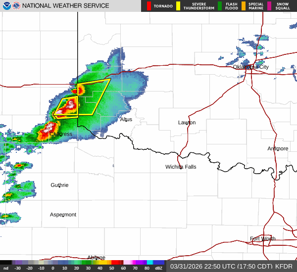
...Southern Kansas into Oklahoma and northwest Texas...
Initiation along the dryline appears likely during the 21-00 UTC
period across western OK into northwest TX as a combination of
diurnal heating and increasing synoptic ascent act to erode
inhibition. Elongated hodographs featuring effective bulk shear
values between 35-45 knots will support initially discrete
supercells capable of large/very large hail and tornadoes (though
uncertainty persists regarding low-level SRH through early evening).
Upscale growth is anticipated at some point during the evening
hours, though there is some uncertainty on when this transition will
occur and the primary threat becomes severe wind. Regardless, an
increase in the nocturnal jet will enlarge low-level hodographs and
maintain the tornado potential into the late evening hours.


Image
Image
0 likes   

rwfromkansas
Category 5
Category 5
Posts: 3038
Joined: Sat Aug 27, 2005 12:47 am
Location: North Fort Worth

Re: Texas Spring 2026

#443 Postby rwfromkansas » Tue Mar 31, 2026 9:52 am

Hoping for more of an MCS for more widespread rains. It sucks being in the hole.
0 likes   

User avatar
JDawg512
Category 5
Category 5
Posts: 1104
Age: 46
Joined: Mon Aug 26, 2013 8:56 pm
Location: Austin
Contact:

Re: Texas Spring 2026

#444 Postby JDawg512 » Tue Mar 31, 2026 9:54 am

Edwards Limestone wrote:I’m not sold on long term forecast. Not that it matters what I think, but the last few years have been brutal down here. It’s like the tap turned off in 2020 and save for some boom/bust cycles and extreme flooding locally, it’s been consistently dry. El Niños don’t always lead to increased rainfall for SCTX as we all saw a couple of years ago.

To me, it seems like the STJ has kind of shifted north the past few years bringing more storm tracks and rainfall to Oklahoma and north/northeast TX. I don’t know. The drought feedback down here is another hurdle to overcome. Years of below average rainfall eventually just becomes average.

That being said, I’ll take every drop we can get.


The STJ has shifted and this is something climate scientists have been saying for years would happen with a heating planet. Unfortunately these feedbacks if they last long enough can become permanent. Fewer and fewer storm systems are swinging through further south and are shunted further away. Heat ridges are becoming stronger much much earlier in the year and cover much larger areas as we saw with this heat wave really only the northeast U.S. has been spared from with their prolonged cold while most of the rest of the country saw record breaking heat. You are also correct that El Niños patterns aren't necessarily sure bets for us in this region to get rain. I'm also not sure where some are getting the idea that El Niño is just gonna switch on at full force in a month or two. Look at the atmospheric pressures for the past 30 to 90 SOI days between Darwin and Tahiti, the atmosphere is not currently affected by the warming waters and reality is we are still only seeing the start of the Kelvin wave build up as it makes its way across the Pacific. Not only that but there is still some residual cold water pooling up. La Niña atmosphericlly is still alive. It takes time for the atmosphere to react to the ocean surface. We will see how April and May turn out and I am hoping those who say wetter times are coming are right because I am the Rain Miser after all, I'll root for rain any day, however I also have to keep my skeptical hat on for now as well.
1 likes   
Resident Rain Miser

I am a weather hobbyist living 3.5 miles south of Downtown Austin and in no way or fashion should anything I say concerning forecasts be taken seriously. Please check your local NWS for accurate weather forecasting and conditions.

snownado
Category 5
Category 5
Posts: 1070
Joined: Sat Dec 09, 2023 7:00 pm
Location: Plano, TX

Re: Texas Spring 2026

#445 Postby snownado » Tue Mar 31, 2026 10:12 am

Warmest March on record for DFW draws to a close, with an average of at least 67.4*F.

It was indeed a little drier than average, but nothing to write home about (2.92")...
0 likes   

User avatar
Ntxw
Storm2k Moderator
Storm2k Moderator
Posts: 23506
Joined: Wed Oct 21, 2009 6:34 pm
Location: DFW, Texas

Re: Texas Spring 2026

#446 Postby Ntxw » Tue Mar 31, 2026 10:42 am

JDawg512 wrote:
Edwards Limestone wrote:I’m not sold on long term forecast. Not that it matters what I think, but the last few years have been brutal down here. It’s like the tap turned off in 2020 and save for some boom/bust cycles and extreme flooding locally, it’s been consistently dry. El Niños don’t always lead to increased rainfall for SCTX as we all saw a couple of years ago.

To me, it seems like the STJ has kind of shifted north the past few years bringing more storm tracks and rainfall to Oklahoma and north/northeast TX. I don’t know. The drought feedback down here is another hurdle to overcome. Years of below average rainfall eventually just becomes average.

That being said, I’ll take every drop we can get.


The STJ has shifted and this is something climate scientists have been saying for years would happen with a heating planet. Unfortunately these feedbacks if they last long enough can become permanent. Fewer and fewer storm systems are swinging through further south and are shunted further away. Heat ridges are becoming stronger much much earlier in the year and cover much larger areas as we saw with this heat wave really only the northeast U.S. has been spared from with their prolonged cold while most of the rest of the country saw record breaking heat. You are also correct that El Niños patterns aren't necessarily sure bets for us in this region to get rain. I'm also not sure where some are getting the idea that El Niño is just gonna switch on at full force in a month or two. Look at the atmospheric pressures for the past 30 to 90 SOI days between Darwin and Tahiti, the atmosphere is not currently affected by the warming waters and reality is we are still only seeing the start of the Kelvin wave build up as it makes its way across the Pacific. Not only that but there is still some residual cold water pooling up. La Niña atmosphericlly is still alive. It takes time for the atmosphere to react to the ocean surface. We will see how April and May turn out and I am hoping those who say wetter times are coming are right because I am the Rain Miser after all, I'll root for rain any day, however I also have to keep my skeptical hat on for now as well.


I am with you on the skepticism, especially with anything cooler than average, but the rains sometimes do switch on a dime when big El Ninos are building. And incoming significant El Nino very rarely, if ever, does not deliver in May with high totals somewhere in the state. SOI is already tanking. If we were talking weaker El Nino set ups now that is a different story, stay hopeful my friend! The big difference from 2018-2023 Nino type events is we now have a +PMM. The irony is that very hot southwest ridge has created conditions more favorable for major El Nino linkage with a hot EPAC.
3 likes   
The above post and any post by Ntxw is NOT an official forecast and should not be used as such. It is just the opinion of the poster and may or may not be backed by sound meteorological data. It is NOT endorsed by any professional institution including Storm2k. For official information, please refer to NWS products.

  Help support Storm2K!
Help Support Storm2K

TomballEd
Category 5
Category 5
Posts: 1293
Age: 62
Joined: Wed Aug 16, 2023 4:52 pm
Location: Spring/Klein area, not Tomball

Re: Texas Spring 2026

#447 Postby TomballEd » Tue Mar 31, 2026 12:17 pm

GFS and Euro starting to converge, as reflect the shower/convective nature of the rain, there are winners and loser. Houston is a loser, but half an inch to an inch isn't a complete bust. Not exactly what I want but I'll take it.
0 likes   

User avatar
txtwister78
Category 5
Category 5
Posts: 2200
Joined: Wed Jan 30, 2019 12:56 pm
Location: San Antonio

Re: Texas Spring 2026

#448 Postby txtwister78 » Tue Mar 31, 2026 12:25 pm

Yup great analysis above by Ntxw showing why there are notable differences with the presentation of this particular El Nino setup compared to the one cited a few years ago (23/24).

Plenty of evidence available now to support a more active and favorable precipitation pattern for Texas not only in April and May as this transition occurs but as I mentioned the other day, we may also have a promising fall season to look forward to as El Nino strengthens as forecast suggest.

My only concern is we gradually chip away at this perma drought we've been under in waves rather than with a massive flood event as we've seen before with these type of El Nino's.
1 likes   

User avatar
wxman22
Category 5
Category 5
Posts: 1940
Joined: Mon Jan 30, 2006 12:39 am
Location: Wichita Falls, TX
Contact:

Re: Texas Spring 2026

#449 Postby wxman22 » Tue Mar 31, 2026 12:42 pm

There it is,SPC upgraded parts of NW Texas and OK to an Enhanced Risk :wink:

Image
Image

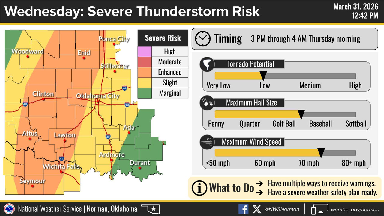
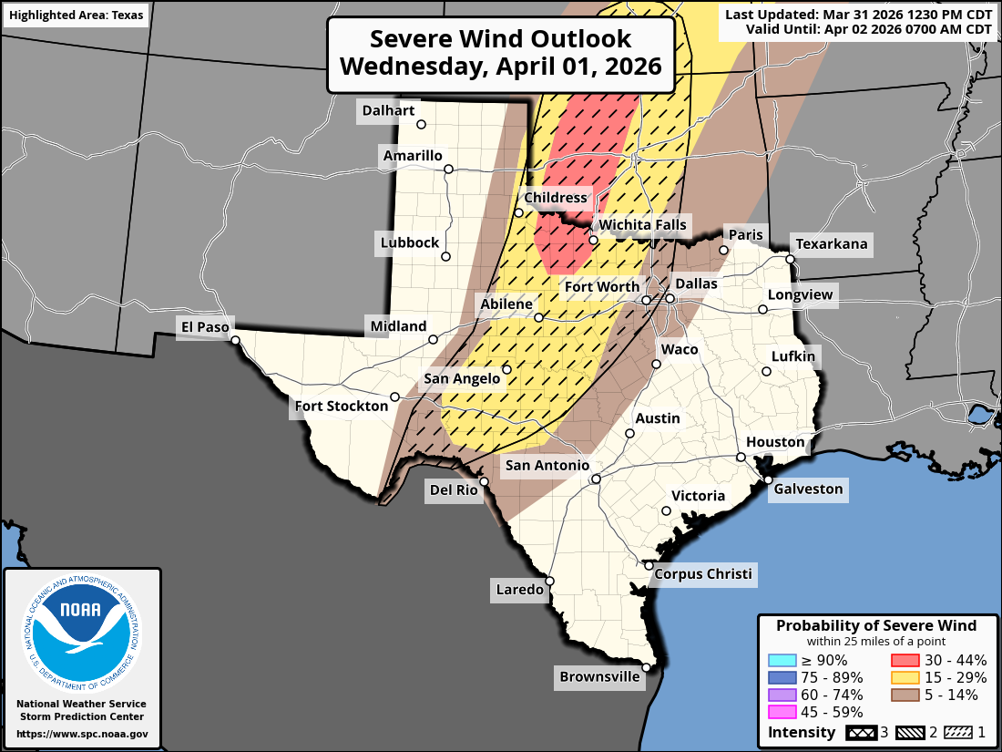
Day 2 Convective Outlook
NWS Storm Prediction Center Norman OK
1230 PM CDT Tue Mar 31 2026

Valid 011200Z - 021200Z

...THERE IS AN ENHANCED RISK OF SEVERE THUNDERSTORMS ACROSS PARTS OF
WESTERN OKLAHOMA...WESTERN NORTH TEXAS...AND SOUTH-CENTRAL KANSAS...

...SUMMARY...
Severe thunderstorms are likely across the southern and central
Plains on Wednesday afternoon and evening. Severe wind gusts, large
hail, and a few tornadoes are the primary concerns. Isolated
strong/severe storms are also possible over parts of the Ohio Valley
into the Mid-Atlantic.

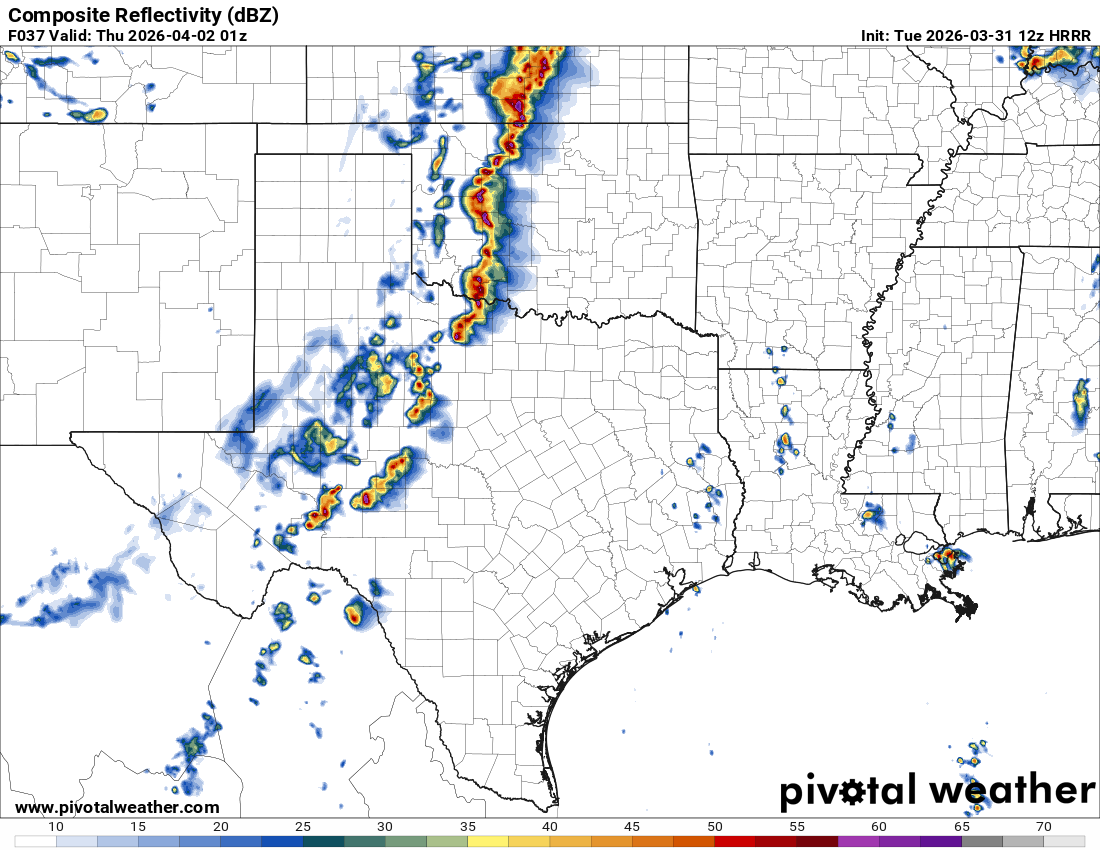
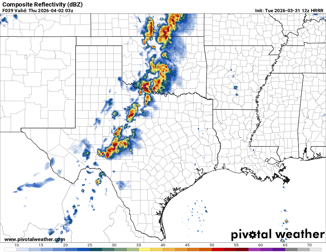
...Southern Plains and Central Plains...
A midlevel trough and accompanying 50-60-kt speed max will advance
eastward from the Great Basin into the southern/central Plains by
Wednesday evening. As related height falls overspread the High
Plains, a lee cyclone will deepen over southeastern CO, while a
southward-extending dryline sharpens over the southern High Plains.
Ample diurnal heating and parcel residence time along the dryline
will promote scattered thunderstorm development in the 20-00Z time
frame -- aided by the strengthening large-scale ascent. Steep
midlevel lapse rates associated with an EML and lower 60s dewpoints
will yield 1500-2000 J/kg MLCAPE in the warm sector. This, combined
with 40-50 kt of effective shear, will favor a mix of semi-discrete
supercells and organized clusters/line segments initially.

The risk of large to very large hail (some 2+ inch diameter) should
be greatest with these initial semi-discrete storms over the
southern/central High Plains. With time, the strengthening DCVA and
expanding cold pools will promote upscale growth into a
north/south-oriented band of storms with embedded supercell
structures -- given elongated hodographs and a substantial
line-orthogonal component to the deep-layer shear. Large hail will
remain possible, though scattered severe wind gusts and a couple
tornadoes will become the main concerns. Additionally, a 40-50+ kt
low-level jet will strengthen ahead of the upscale-growing
convection into the evening, resulting in expanding clockwise-curved
hodographs and additional concerns for a few tornadoes. Higher
tornado probabilities may eventually be needed once confidence in
where the risk will be maximized spatially. Storms will track
eastward across the I-35 corridor into the overnight hours and
continue to pose a damaging-wind risk and perhaps embedded
tornadoes. However, confidence in the overall severe-risk decreases
with eastward extent.
Last edited by wxman22 on Tue Mar 31, 2026 1:14 pm, edited 1 time in total.
0 likes   

Stratton23
Category 5
Category 5
Posts: 3561
Joined: Fri Jul 21, 2023 10:59 pm
Location: Katy, Tx

Re: Texas Spring 2026

#450 Postby Stratton23 » Tue Mar 31, 2026 1:13 pm

its long range but boy oh boy the GFS and Euro are both absolutely gully washers, incredibly wet runs
1 likes   

User avatar
Ntxw
Storm2k Moderator
Storm2k Moderator
Posts: 23506
Joined: Wed Oct 21, 2009 6:34 pm
Location: DFW, Texas

Re: Texas Spring 2026

#451 Postby Ntxw » Tue Mar 31, 2026 2:31 pm

Stratton23 wrote:its long range but boy oh boy the GFS and Euro are both absolutely gully washers, incredibly wet runs


Hawaii has seen some torrential rainfall from a couple of Kona lows. The WWB event is definitely playing a role and as it marches eastward and excites, the STJ will string from that region up to ours in April. Any southwest low system will likely meander and pull a lot of it up.
3 likes   
The above post and any post by Ntxw is NOT an official forecast and should not be used as such. It is just the opinion of the poster and may or may not be backed by sound meteorological data. It is NOT endorsed by any professional institution including Storm2k. For official information, please refer to NWS products.


  Help support Storm2K!

Help Support Storm2K


User avatar
txtwister78
Category 5
Category 5
Posts: 2200
Joined: Wed Jan 30, 2019 12:56 pm
Location: San Antonio

Re: Texas Spring 2026

#452 Postby txtwister78 » Tue Mar 31, 2026 3:15 pm

Pattern remains active next week

Image
3 likes   

User avatar
TeamPlayersBlue
Category 5
Category 5
Posts: 3531
Joined: Tue Feb 02, 2010 1:44 am
Location: Denver/Applewood, CO

Re: Texas Spring 2026

#453 Postby TeamPlayersBlue » Tue Mar 31, 2026 3:46 pm

Ntxw wrote:
Stratton23 wrote:its long range but boy oh boy the GFS and Euro are both absolutely gully washers, incredibly wet runs


Hawaii has seen some torrential rainfall from a couple of Kona lows. The WWB event is definitely playing a role and as it marches eastward and excites, the STJ will string from that region up to ours in April. Any southwest low system will likely meander and pull a lot of it up.


This is what im hoping for here in CO as well. Easily the driest, warmest winters in history and now we are on fire watch. We need the snow/rains ASAP. The transition is a positive development and ready to start seeing the changes on the models.
Looking at the models, starting to see how the dry ground here is affecting the atmosphere itself. Less snow, drier ground. Less Albedo, also the high pressure can really anchor itself over the Desert southwest, so we really need this flip to happen. I think there are plenty of patterns that help us both.
0 likes   
Personal Forecast Disclaimer:
The posts in this forum are NOT official forecast and should not be used as such. They are just the opinion of the poster and may or may not be backed by sound meteorological data. They are NOT endorsed by any professional institution or storm2k.org. For official information, please refer to the NHC and NWS products.

User avatar
CaptinCrunch
S2K Supporter
S2K Supporter
Posts: 8780
Age: 58
Joined: Mon Nov 03, 2003 4:33 pm
Location: Kennedale, TX (Tarrant Co.)

Re: Texas Spring 2026

#454 Postby CaptinCrunch » Tue Mar 31, 2026 4:31 pm

TomballEd wrote:GFS and Euro starting to converge, as reflect the shower/convective nature of the rain, there are winners and loser. Houston is a loser, but half an inch to an inch isn't a complete bust. Not exactly what I want but I'll take it.


but half an inch to an inch isn't a complete bust. Not exactly what I want but I'll take it....That's what see she said :lol:

Now back to our regularly scheduled forecast....
0 likes   

User avatar
wxman22
Category 5
Category 5
Posts: 1940
Joined: Mon Jan 30, 2006 12:39 am
Location: Wichita Falls, TX
Contact:

Re: Texas Spring 2026

#455 Postby wxman22 » Tue Mar 31, 2026 4:51 pm

Image

Image
0 likes   

cstrunk
Category 2
Category 2
Posts: 727
Joined: Sat Jul 04, 2020 10:38 am
Location: Longview, TX

Re: Texas Spring 2026

#456 Postby cstrunk » Tue Mar 31, 2026 6:35 pm

My old Tempest Weatherflow station finally bit the dust. The temp sensors quit last summer. The rainfall sensor quit last month and that was the last straw. Tempest support said there was nothing they could do except offer me the new upgraded weather station at half cost. I took them up on that offer and just got it installed.
Last edited by cstrunk on Tue Mar 31, 2026 6:37 pm, edited 1 time in total.
0 likes   

User avatar
wxman22
Category 5
Category 5
Posts: 1940
Joined: Mon Jan 30, 2006 12:39 am
Location: Wichita Falls, TX
Contact:

Re: Texas Spring 2026

#457 Postby wxman22 » Tue Mar 31, 2026 6:35 pm

Looks like the storms to the west will congeal into a line of storms tonight and die out over the area.This will likely leave a boundary for storms to work with tomorrow along with the dryline.The "pre game" before tomorrow lol. In Wichita Falls we missed out on most of the rain with the last severe weather sequence earlier this month. So i am happy that things are looking better for rain this time here.
0 likes   

User avatar
wxman22
Category 5
Category 5
Posts: 1940
Joined: Mon Jan 30, 2006 12:39 am
Location: Wichita Falls, TX
Contact:

Re: Texas Spring 2026

#458 Postby wxman22 » Tue Mar 31, 2026 9:20 pm

Yikes! that supercell ongoing in Paducah means business.Large hail and damaging winds along with flooding occurring right now.

https://www.facebook.com/share/v/1C89KGQUaJ/

https://www.facebook.com/share/v/1Aroigw9bB/
0 likes   

869MB
S2K Supporter
S2K Supporter
Posts: 181
Joined: Thu Feb 14, 2019 9:49 pm
Location: Katy, TX

Re: Texas Spring 2026

#459 Postby 869MB » Tue Mar 31, 2026 9:24 pm

We can only hope that this verifies...

 https://x.com/WeatherCast3/status/2039121679125709178


Latest CANSIPS for the rest of spring into summer looks great in Texas as far as rain goes. All that rain in Mexico also helps keep a lid on sustained heat into summer if this plays out. Things look promising for a a wetter and cooler summer than years past in the southern plains should this hole. Time will tell.
0 likes   


Return to “USA & Caribbean Weather”

Who is online

Users browsing this forum: Cpv17, South Texas Storms and 96 guests