Page 24 of 73

Re: Texas Summer 2022

Posted: Tue Jul 05, 2022 10:06 am
by Brent
There's already a heat advisory til at least Thursday here :spam: this is horrible

Hopefully that front next week is legit

Re: Texas Summer 2022

Posted: Tue Jul 05, 2022 10:29 am
by underthwx
Brent wrote:There's already a heat advisory til at least Thursday here :spam: this is horrible

Hopefully that front next week is legit


And some rain along with it

Re: Texas Summer 2022

Posted: Tue Jul 05, 2022 11:58 am
by Ntxw
Brent wrote:There's already a heat advisory til at least Thursday here :spam: this is horrible

Hopefully that front next week is legit


Depends on what your expectations of cool down is. If down to 95-100F from 100-105F and 0% rainfall to 10-30% then yes for Tulsa. The forecast discussions note it due to the ridge shifting, but there isn't blocking up north causing a breakdown. It's just shifts of the ridge, so it's not lasting.

There is a little good news the PDO for June rose after being elevated most of the year. Would like to see a string of several more months in that direction.

Image

Re: Texas Summer 2022

Posted: Tue Jul 05, 2022 12:23 pm
by Iceresistance
This is going to be a long week . . .

Up to 103 now, but still bad. :(

Re: Texas Summer 2022

Posted: Tue Jul 05, 2022 12:26 pm
by underthwx
Iceresistance wrote:This is going to be a long week . . .

Up to 103 now, but still bad. :(


Let a smile be your umbrella Ice, sooner or later the rain will fall...

Re: Texas Summer 2022

Posted: Tue Jul 05, 2022 1:07 pm
by ElectricStorm
As someone who has an outdoor job, this week is absolutely brutal. The last two summers weren't that bad but this year is really bringing the heat...

Re: Texas Summer 2022

Posted: Tue Jul 05, 2022 1:14 pm
by underthwx
ElectricStorm wrote:As someone who has an outdoor job, this week is absolutely brutal. The last two summers weren't that bad but this year is really bringing the heat...


True that, my delivery vehicle is basically a BBQ pit on wheels during the heat of the day

Re: Texas Summer 2022

Posted: Tue Jul 05, 2022 4:13 pm
by captainbarbossa19
Ntxw wrote:
Brent wrote:There's already a heat advisory til at least Thursday here :spam: this is horrible

Hopefully that front next week is legit


Depends on what your expectations of cool down is. If down to 95-100F from 100-105F and 0% rainfall to 10-30% then yes for Tulsa. The forecast discussions note it due to the ridge shifting, but there isn't blocking up north causing a breakdown. It's just shifts of the ridge, so it's not lasting.

There is a little good news the PDO for June rose after being elevated most of the year. Would like to see a string of several more months in that direction.

https://i.imgur.com/xhsKTX2.png


That's the lowest value since August last year. Woohoo!

Re: Texas Summer 2022

Posted: Tue Jul 05, 2022 8:47 pm
by Iceresistance
underthwx wrote:
Iceresistance wrote:This is going to be a long week . . .

Up to 103 now, but still bad. :(


Let a smile be your umbrella Ice, sooner or later the rain will fall...

Perfect timing, there is now at 10 to 15% chance of storms in the next few days. The heat wave is still gonna be brutal though.

Re: Texas Summer 2022

Posted: Tue Jul 05, 2022 11:44 pm
by Brent
Still 91 at the airport at this hour :spam: I just don't know what else to say about this week at this point
Re: Texas Summer 2022

Posted: Wed Jul 06, 2022 9:22 am
by Ntxw
Regional AFDs are slowly ramping up their verbiage for the weekend. It looks like a large portion of the state may go under excessive heat watch and eventually excessive heat warnings. Much will rely on the stalling front way to the north. Compressional heating may produce the hottest temps of the season over the weekend for many.

FW snippet:

To simplify messaging, our current Heat Advisory runs through the
rest of the work week. However, an Excessive Heat Watch may be
issued later today for Friday and Saturday. We have decided to
hold off on issuing the Watch tonight because the front could
cause our temperature and heat index forecast for Saturday to be
adjusted below Excessive Heat Warning criteria for some counties
and therefore preclude the issuance of the warning. As confidence
grows that the front will remain to our north and there will not
be much precip along the front, an Excessive Heat Watch and/or
Warning will be needed for parts of the area Friday and Saturday.

Heat will continue Sunday and early next week, but depending on
which guidance you prefer, rain chances return to the area along
a stalled front. Not to be a Debbie Downer, but our forecast has
sided with the drier guidance since the globals have a bias to
break down ridges quicker than they actually do. That means high
temperatures above 100F with heat index values between 105-115F
are forecast to continue through at least Wednesday of next week.
Our best hope will be that a trough over the Eastern CONUS next
week deepens enough to allow a backdoor front into the area, but I
wouldn`t get your hopes up just yet.


EWX

.LONG TERM...
(Thursday night through Tuesday)
Issued at 305 AM CDT Wed Jul 6 2022

Thursday night into Friday, the mid-level section of the ridging
aloft shifts focus into the Southern Rockies as a troughing pattern
over the Pacific coast lifts NE and amplifies a broader N-S ridge
axis northward into Canada. Some 597 dm heights begin to take shape
with parts of this enhanced ridging extending east over the TX
Panhandle. This pattern of highest heights is typical of those that
give the Central TX region some of our hottest temps and also lead to
a relatively light surface wind. There will be good chances that
we`ll have to issue a heat advisory for some areas by Friday, and
this heat is only expected to amplify further over the weekend into
Monday. Friday may continue to have the dew points holding in the mid
and upper 60s in the mid afternoon hours which should lead to a
higher percentage of the forecast area with heat index values in the
105-110 degree range.

With the southerly breezes becoming lighter and less efficient in
transporting Gulf moisture inland this weekend, we should see an end
to the morning low clouds and the ambient temps begin reaching up to
105 for a lot more areas besides our usual Rio Grande Plains
locations. This may put us in position to consider Excessive Heat
Warnings this weekend into Monday. The pattern aloft flattens from
the north Monday as a polar trough pushes into the upper Mississippi
valley. The GFS also suggests some East TX convection moving west
along the southern periphery of the ridge, but the signal doesn`t
look strong enough to consider any rain chances for now. A weak
inverted trough lifts into Deep South TX Tuesday, and this could be
another pattern to watch for in the low hopes of seeing the heat wave
pattern break down. Will keep our extended forecast dry until we get
a more consistent signal for decreasing stability
.


Tulsa

I`m sure most of the people are already tired of the
heat...unfortunately, it is not going anywhere. A mid-level ridge
will continue to be positioned across most of the Southern Plains
into the weekend. A heat advisory is in effect for Thursday across
the eastern two-thirds of the area from 1-8pm. A cool front is
expected to make its way into the area Thursday night into Friday
with cooler temperatures accompanying it (relative to what we
have had). Showers and a few storms are possible along this
boundary, mainly across northern and western Oklahoma Friday early
morning. The cool front will attempt to push southward, cooling
temperatures slightly north of I-40 into the upper 90s. The rest
of the area will feel the effects that evening and into Saturday,
where the highs will get into the mid to upper 90s. Unfortunately,
winds will shift over the weekend to where we will get reinforced
Midwest moisture, where moisture will pool in most areas.
Dewpoints will likely get into the low 70s through early next
week. Temperatures should gradually climb back into the triple
digits early next week. Additional heat advisories will most
likely be necessary.


DFW is right now at 89.1F on pace for a top 5 hottest July, albeit about a week sample size. That's almost 5F above normal (new averages in 2020 had already brought the baseline up as it was). Unless we spend a significant week or two below normal, it is quite likely we will add to May and June as a top 5 warm month.

CPC forecast keeps above normal temps 2/3rds way through July.

Image

A lot of the word 'hope' seems to be in these discussions from the NWS. That's the theme this summer, hope.

Hey it will be wet and cool in Atlanta with the next trough!!! :grr:

Re: Texas Summer 2022

Posted: Wed Jul 06, 2022 1:29 pm
by wxman57
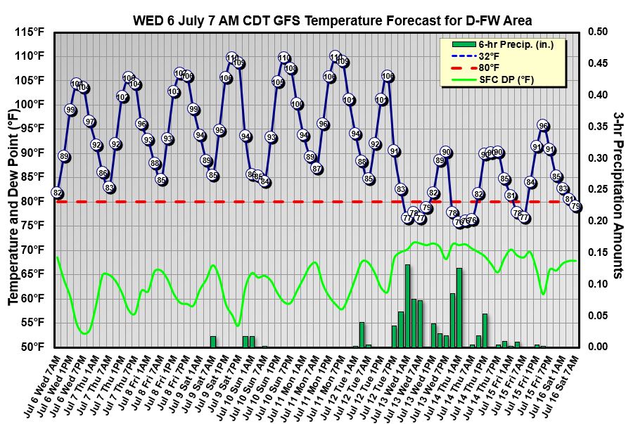
Looks like it might just be warm enough for a bike ride in Dallas-Ft. Worth this weekend and early next week. After Monday, the GFS has rain moving in and highs only near 90. Brrr! Hope you get the rain.

Image

Re: Texas Summer 2022

Posted: Wed Jul 06, 2022 2:22 pm
by cstrunk
wxman57 wrote:Looks like it might just be warm enough for a bike ride in Dallas-Ft. Worth this weekend and early next week. After Monday, the GFS has rain moving in and highs only near 90. Brrr! Hope you get the rain.

http://wxman57.com/images/DFW.JPG


Definitely hope most people can cash in on some rain because on either side of the ~3 "cool/wet" stretch you've got a lot of days at ~105-110F+ for much of the region....

Re: Texas Summer 2022

Posted: Thu Jul 07, 2022 8:33 am
by cstrunk
The last few runs of the GFS want to bring some tropical moisture into S LA or SE TX around next Friday. The 06z really slams SE TX with around a foot of rain. Highly likely I'd throw this out because it's only showing a 21z temperature of 69F here next Saturday. :cold:

Otherwise, the last few runs still generally shows highs in the 100's+ until the mid-week time frame, when we might cool down into the 90's.

Re: Texas Summer 2022

Posted: Thu Jul 07, 2022 8:42 am
by Ntxw
MJO is trying to make it out into the Pacific (hasn't happened yet) per guidance. Definitely watch the SOI in the coming weeks, if it can sustain negatives then we know the MJO/rising motion out in the Pacific may shake the pattern with success. It would be towards the end of the month and August to bear fruit if it's real. Trade surges out there fighting it though, hopeful.

Re: Texas Summer 2022

Posted: Thu Jul 07, 2022 10:58 am
by Cpv17
Ntxw wrote:MJO is trying to make it out into the Pacific (hasn't happened yet) per guidance. Definitely watch the SOI in the coming weeks, if it can sustain negatives then we know the MJO/rising motion out in the Pacific may shake the pattern with success. It would be towards the end of the month and August to bear fruit if it's real. Trade surges out there fighting it though, hopeful.


The forecast is looking a bit better for my neck of the woods beginning the middle part of next week.
Re: Texas Summer 2022

Posted: Thu Jul 07, 2022 11:07 am
by Ntxw
Cpv17 wrote:
Ntxw wrote:MJO is trying to make it out into the Pacific (hasn't happened yet) per guidance. Definitely watch the SOI in the coming weeks, if it can sustain negatives then we know the MJO/rising motion out in the Pacific may shake the pattern with success. It would be towards the end of the month and August to bear fruit if it's real. Trade surges out there fighting it though, hopeful.


The forecast is looking a bit better for my neck of the woods beginning the middle part of next week.


I am hoping the GFS is correct with gulf feature meandering w/nw into the state. It needs to do better than 95L did outside of the golden triangle. Fingers crossed.

Re: Texas Summer 2022

Posted: Thu Jul 07, 2022 12:35 pm
by Iceresistance
103°F Yesterday, expected to reach 105°F today and now tomorrow (30% chance of storms tomorrow)

Re: Texas Summer 2022

Posted: Thu Jul 07, 2022 4:34 pm
by captainbarbossa19
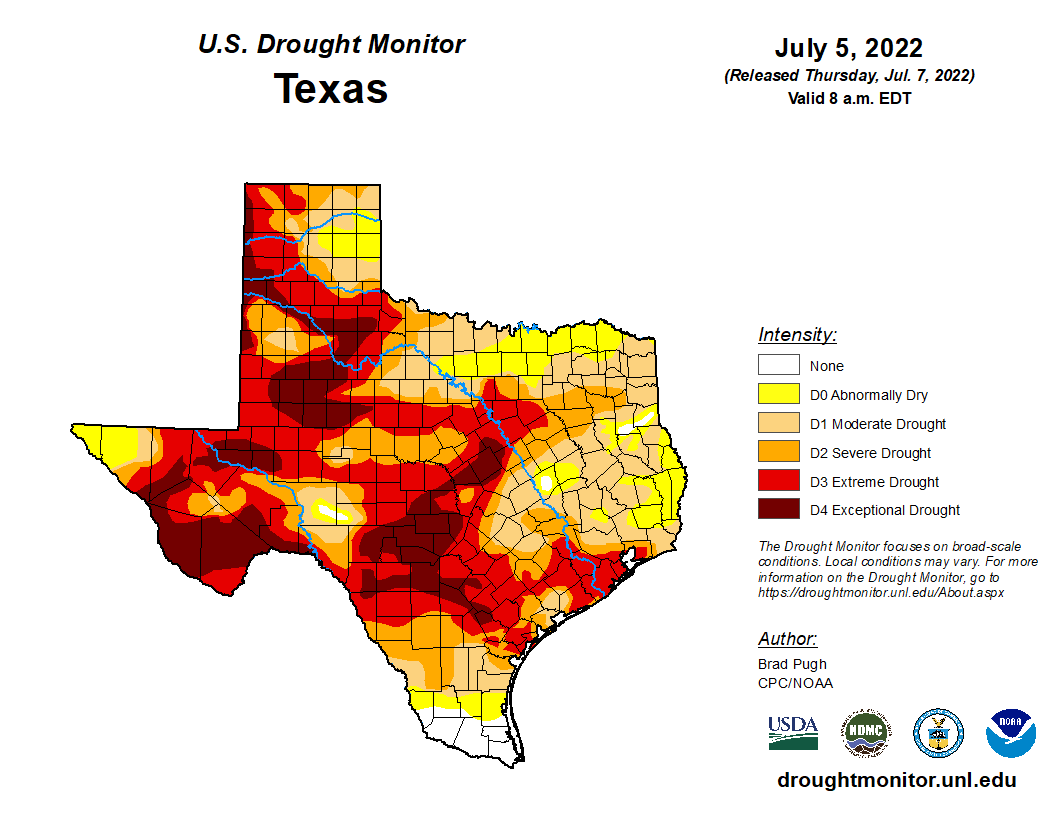
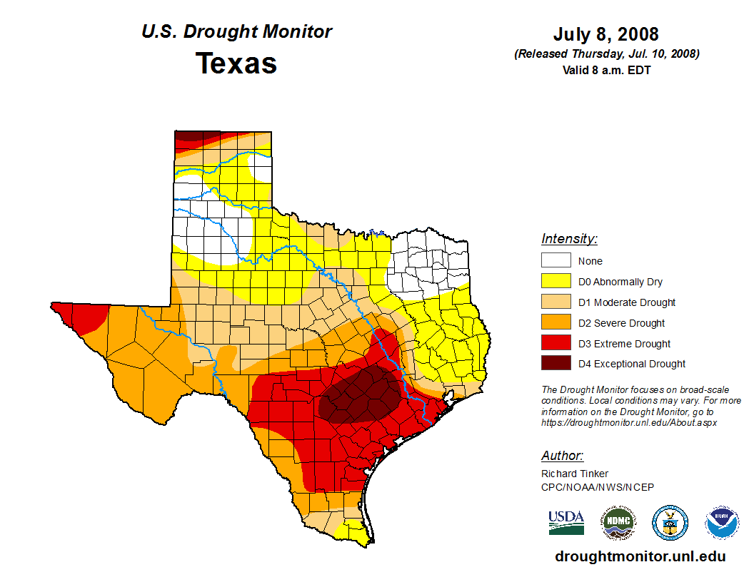
This year gives me hope in some ways. Definitely not 2011, but thought I would share some similar years. I think the closet year of the group is actually 2008.

Image
Image
Image
Image
Image

Re: Texas Summer 2022

Posted: Thu Jul 07, 2022 8:08 pm
by Ntxw
103F today for DFW, 14th day of 100+. Excessive heat warnings are up through the weekend for the metroplex and EWX is mentioning they may but depends on humidity.

Some possible scenarios for the rest of July.

Sample size if DFW finished the rest of July near normal (95-97F average high and 75-77 average low) we would finish around ~88.5F or 8th-ish warmest.

If +2F degrees or so the rest of the way (98-100) we'd get over the 90F mark which will place it in the top tier warm years.

Assuming we run -2F below normal (94-96 for highs, and mid 70s for lows) the rest of the way we will still likely finish top 10 at 88F.

If the current 4-5F above pace is held we will be top 3 warmest. The lows will have a big say in this as compared to normal they are the highest departures so far. Realistically 1980 at 92F, the warmest looks safe barring some string of 110s.