

Cyclone1 wrote:*looks at the week's forecast*
Ah, finally. Looks like this is more then just an isolated event. We're in summer, baby.
Florida Weather
Moderator: S2k Moderators
Forum rules

The posts in this forum are NOT official forecast and should not be used as such. They are just the opinion of the poster and may or may not be backed by sound meteorological data. They are NOT endorsed by any professional institution or STORM2K.


-
dolebot_Broward_NW
- Category 2

- Posts: 529
- Joined: Fri Sep 10, 2004 6:38 am
-
gatorcane

- S2K Supporter

- Posts: 23708
- Age: 48
- Joined: Sun Mar 13, 2005 3:54 pm
- Location: Boca Raton, FL
Re: Florida Weather Thread: Rainy season is here
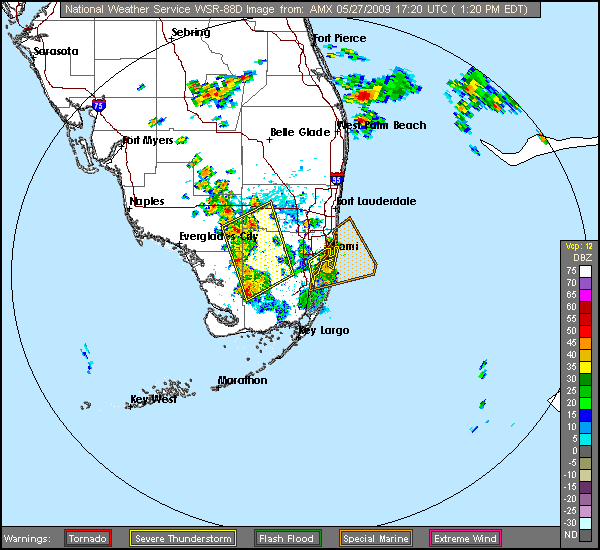
SEVERE WEATHER STATEMENT
NATIONAL WEATHER SERVICE MIAMI FL
138 PM EDT WED MAY 27 2009
FLC011-021-086-087-271800-
/O.CON.KMFL.SV.W.0036.000000T0000Z-090527T1800Z/
COLLIER FL-BROWARD FL-MAINLAND MONROE FL-MIAMI-DADE FL-
138 PM EDT WED MAY 27 2009
...A SEVERE THUNDERSTORM WARNING REMAINS IN EFFECT UNTIL 200 PM EDT
FOR NORTHWESTERN MIAMI-DADE...NORTHEASTERN MAINLAND MONROE...
SOUTHWESTERN BROWARD AND SOUTHEASTERN COLLIER COUNTIES...
AT 138 PM EDT...NATIONAL WEATHER SERVICE DOPPLER RADAR CONTINUED TO
INDICATE A LINE OF SEVERE THUNDERSTORMS CAPABLE OF PRODUCING PENNY
SIZE HAIL...AND DAMAGING WINDS IN EXCESS OF 60 MPH. THESE STORMS WERE
LOCATED ALONG A LINE EXTENDING FROM 11 MILES NORTH OF DADE-COLLIER
TRAINING AIRPORT TO 14 MILES SOUTH OF SHARK VALLEY OBS TOWER...MOVING
NORTHEAST AT 5 MPH.
REPORT SEVERE WEATHER OR DAMAGE TO THE NEAREST LAW ENFORCEMENT AGENCY
OR YOUR COUNTY EMERGENCY MANAGEMENT. THEY WILL RELAY YOUR REPORT TO
THE NATIONAL WEATHER SERVICE FORECAST OFFICE IN MIAMI. OR YOU CAN
ALSO CALL THE NATIONAL WEATHER SERVICE IN MIAMI DIRECTLY AT
305.229.4528 TO REPORT SEVERE WEATHER.
LAT...LON 2620 8065 2551 8067 2541 8084 2600 8104
TIME...MOT...LOC 1738Z 241DEG 3KT 2601 8094 2546 8083
$$
TINGLER
0 likes
-
gatorcane
- S2K Supporter
- Posts: 23708
- Age: 48
- Joined: Sun Mar 13, 2005 3:54 pm
- Location: Boca Raton, FL
weather.gov
National Weather Service
Watches, Warnings & Advisories
Local weather forecast by "City, St" or zip code
--------------------------------------------------------------------------------
Special Weather Statement
--------------------------------------------------------------------------------
SPECIAL WEATHER STATEMENT
NATIONAL WEATHER SERVICE MIAMI FL
249 PM EDT WED MAY 27 2009
FLZ067-271930-
INLAND PALM BEACH COUNTY FL-
249 PM EDT WED MAY 27 2009
...STRONG THUNDERSTORMS MOVING ACROSS WESTERN PALM BEACH COUNTY...
AT 246 PM EDT...NATIONAL WEATHER SERVICE DOPPLER RADAR INDICATED
STRONG THUNDERSTORMS ALONG A LINE EXTENDING FROM PORT MAYACA TO 7
MILES SOUTHWEST OF PAHOKEE...MOVING SOUTHEAST AT 20 MPH.
THESE STORMS WILL AFFECT...
CANAL POINT...
BELLE GLADE...
AND SURROUNDING COMMUNITIES. A STRONG OUTFLOW BOUNDARY WILL PRECEDE
THE THUNDERSTORM WITH WINDS UP TO 50 MPH AS WELL.
THE PRIMARY IMPACTS WILL BE FREQUENT TO EXCESSIVE LIGHTNING AND GUSTY
WINDS OF 40 TO 50 MPH...WHICH CAN DOWN SMALL TREE LIMBS AND
BRANCHES...AND BLOW AROUND UNSECURED SMALL OBJECTS. LIGHTNING IS THE
NUMBER ONE WEATHER RELATED KILLER IN FLORIDA. TREES AND OPEN SHELTERS
OFFER NO PROTECTION. SEEK SHELTER IN A SAFE BUILDING UNTIL THE STORM
PASSES.
0 likes
-
gatorcane
- S2K Supporter
- Posts: 23708
- Age: 48
- Joined: Sun Mar 13, 2005 3:54 pm
- Location: Boca Raton, FL
Re: Florida Weather Thread: Rainy season is here
weather.gov
National Weather Service
Watches, Warnings & Advisories
Local weather forecast by "City, St" or zip code
8 products issued by NWS for: 3 Miles S Royal Palm Beach FL
--------------------------------------------------------------------------------
Severe Thunderstorm Warning
SEVERE THUNDERSTORM WARNING
FLC099-272015-
/O.NEW.KMFL.SV.W.0039.090527T1921Z-090527T2015Z/
BULLETIN - EAS ACTIVATION REQUESTED
SEVERE THUNDERSTORM WARNING
NATIONAL WEATHER SERVICE MIAMI FL
321 PM EDT WED MAY 27 2009
THE NATIONAL WEATHER SERVICE IN MIAMI HAS ISSUED A
* SEVERE THUNDERSTORM WARNING FOR...
NORTHEASTERN PALM BEACH COUNTY IN SOUTH FLORIDA.
* UNTIL 415 PM EDT
* AT 316 PM EDT...NATIONAL WEATHER SERVICE DOPPLER RADAR INDICATED A
LINE OF SEVERE THUNDERSTORMS CAPABLE OF PRODUCING QUARTER SIZE
HAIL...AND DAMAGING WINDS IN EXCESS OF 60 MPH. THESE STORMS WERE
LOCATED ALONG A LINE EXTENDING FROM 4 MILES SOUTH OF WEST PALM
BEACH TO 6 MILES SOUTHWEST OF WELLINGTON...AND MOVING NORTHEAST
AT 20 MPH.
* THE LINE OF STORMS WILL AFFECT...
GOLDEN LAKES...
ROYAL PALM BEACH...
PORT OF PALM BEACH...
RIVIERA BEACH...
NORTH PALM BEACH...
PALM BEACH GARDENS...
AND SURROUNDING COMMUNITIES.
OTHER POSSIBLY SEVERE THUNDERSTORMS WILL AFFECT THE WEST PALM BEACH
AREA...AS WELL AS AREAS NEAR AND WEST OF LAKE WORTH AS WELL AS LION
COUNTRY SAFARI.
FREQUENT LIGHTNING IS OCCURRING WITH THIS THUNDERSTORM. IF
OUTDOORS...STAY AWAY FROM ISOLATED HIGH OBJECTS SUCH AS TREES AND
AVOID WATER. MOVE INDOORS OR INSIDE A VEHICLE IF POSSIBLE. AVOID
USING THE TELEPHONE UNLESS IT IS AN EMERGENCY. TRY TO UNPLUG
UNNECESSARY ELECTRICAL APPLIANCES BEFORE THE THUNDERSTORM APPROACHES.
THIS STORM HAS A HISTORY OF PRODUCING QUARTER HAIL. WIND GUSTS TO 60
MPH ARE ALSO POSSIBLE. SEEK SHELTER NOW INSIDE A STURDY STRUCTURE
AND STAY AWAY FROM WINDOWS!
LAT...LON 2670 8005 2665 8005 2658 8042 2667 8063
2690 8039 2696 8015 2698 8014 2698 8007
2690 8004 2684 8004 2682 8002 2678 8002
2678 8005 2675 8002
TIME...MOT...LOC 1919Z 203DEG 18KT 2666 8004 2661 8031
$$
GS
0 likes


Hazardous Weather Outlook
Severe Thunderstorm Warning
Severe Weather Statement
Short Term Forecast
Special Weather Statement
http://radar.weather.gov/radar.php?rid= ... 11&loop=no
looks like we are in for it. Seems to be getting worse once again around us.
Severe Thunderstorm Warning
Severe Weather Statement
Short Term Forecast
Special Weather Statement
http://radar.weather.gov/radar.php?rid= ... 11&loop=no
looks like we are in for it. Seems to be getting worse once again around us.
0 likes
-
gatorcane
- S2K Supporter
- Posts: 23708
- Age: 48
- Joined: Sun Mar 13, 2005 3:54 pm
- Location: Boca Raton, FL
Re:
artist wrote:Hazardous Weather Outlook
Severe Thunderstorm Warning
Severe Weather Statement
Short Term Forecast
Special Weather Statement
http://radar.weather.gov/radar.php?rid= ... 11&loop=no
looks like we are in for it. Seems to be getting worse once again around us.
Well that deserves a
0 likes
-
dolebot_Broward_NW
- Category 2
- Posts: 529
- Joined: Fri Sep 10, 2004 6:38 am
Re: Florida Weather Thread: Rainy season is here
Today doesn't seem to be nearly as severe as the past two in Broward at least.
0 likes
Re: Re:
gatorcane wrote:artist wrote:Hazardous Weather Outlook
Severe Thunderstorm Warning
Severe Weather Statement
Short Term Forecast
Special Weather Statement
http://radar.weather.gov/radar.php?rid= ... 11&loop=no
looks like we are in for it. Seems to be getting worse once again around us.
Well that deserves a
at least it is moving out quickly. Still raining pretty hard here with thunder, but not as bad as 20 minutes ago. Looking on radar it just might be out of here within the next 20 minutes or so, of course that is if it doesn't build back again. lol
0 likes
oh and just checked the rain gauge - added another 4 inches in the last 30 minutes and it is still coming down steady (not torrential as about 20 minutes ago) right now. That is on top of the 14 inches we have gotten in the last 2 weeks. We are gonna float away soon at this rate! Where oh where is that dry air and  we hated so much for so long?
we hated so much for so long?
0 likes
-
gatorcane
- S2K Supporter
- Posts: 23708
- Age: 48
- Joined: Sun Mar 13, 2005 3:54 pm
- Location: Boca Raton, FL
Re:
artist wrote:oh and just checked the rain gauge - added another 4 inches in the last 30 minutes and it is still coming down steady (not torrential as about 20 minutes ago) right now. That is on top of the 14 inches we have gotten in the last 2 weeks. We are gonna float away soon at this rate! Where oh where is that dry air and
I'm in a part of West Palm Beach that seems to have missed alot of those heavier rains, I'm guessing we have received about 4-5 inches over the past couple of weeks....seems that they pass north south east and west of us..but not through us.
We still have about 4-5 days of this pattern left so I'm hopeful we'll get a big cell at some point.
0 likes
yeah, we live in the Acreage and have a big pond (dug to build the house pad up)that was down about 5 feet. It is now just to the top of it's bank, just beginning to spill over on the lower end of it. Hubby built a bridge over it this spring and tried to use the level of the water from after Frances and Jeanne came through so it would stay above any major storms rain. Well, if we get too much more without a break, the bridge could just about go under. It is about a foot from the bottom of the bridge now. And 2 weeks ago we were worried about the fish and turtles as it had become so shallow. What a difference a couple of weeks can make! lol Gator, youa remore than welcome to come get some of our water!
0 likes
-
gatorcane
- S2K Supporter
- Posts: 23708
- Age: 48
- Joined: Sun Mar 13, 2005 3:54 pm
- Location: Boca Raton, FL
Re:
artist wrote:yeah, we live in the Acreage and have a big pond (dug to build the house pad up)that was down about 5 feet. It is now just to the top of it's bank, just beginning to spill over on the lower end of it. Hubby built a bridge over it this spring and tried to use the level of the water from after Frances and Jeanne came through so it would stay above any major storms rain. Well, if we get too much more without a break, the bridge could just about go under. It is about a foot from the bottom of the bridge now. And 2 weeks ago we were worried about the fish and turtles as it had become so shallow. What a difference a couple of weeks can make! lol Gator, youa remore than welcome to come get some of our water!
Oh so you are farther west so that makes sense, it typically rains more inland, I'm more by 441 and farther east.
Just to let you know the ECMWF paints a very rainy picture for South Florida, especially for Saturday as a piece of energy spins off from a short-wave from the GOM. Check out this discussion snippet from NWS:
FOR THE WEEKEND...HAVE DISCOUNTED THE GFS AS THE LATEST 12Z RUN
(ALONG WITH PREVIOUS RUNS) HAVE BEEN SUFFERING FROM A SEVERE CASE
OF CONVECTIVE FEEDBACK AND SO IS UNRELIABLE. ECWMF LOOKS MORE
REASONABLE...AND HAS BEEN MORE CONSISTENT. THIS MODEL SHOWS A
POTENTIALLY VERY ACTIVE SATURDAY AS A LARGE AMPLITUDE TROUGH MOVES
ACROSS THE AREA. HAVE INCREASED POPS SLIGHTLY ALONG THE ATLANTIC
COAST FOR SATURDAY. IF THE ECWMF VERIFIES...THESE POPS ARE STILL
WAY TOO LOW. BUT GIVEN UNCERTAINTIES FOR THIS WEEKEND...DID NOT
MAKE SIGNIFICANT CHANGES AND WE CAN REFINE THIS DOWN THE ROAD.
Nonetheless POPS are well above CLIMO for the remainder of the week with rain chances around 70% through Sat. or so....
0 likes
Re: Florida Weather Thread: Rainy season is here
A line of rain moving in from the west today. Cooler, overcast.
0 likes
-
gatorcane
- S2K Supporter
- Posts: 23708
- Age: 48
- Joined: Sun Mar 13, 2005 3:54 pm
- Location: Boca Raton, FL
Re: Florida Weather Thread: Rainy season is here
SPECIAL WEATHER STATEMENT
NATIONAL WEATHER SERVICE MIAMI FL
1254 PM EDT THU MAY 28 2009
FLZ067-281730-
INLAND PALM BEACH COUNTY FL-
1254 PM EDT THU MAY 28 2009
...STRONG THUNDERSTORM MOVING ACROSS THE LOXAHATCHEE REFUGE...
AT 1253 PM EDT...NATIONAL WEATHER SERVICE DOPPLER RADAR INDICATED A
STRONG THUNDERSTORM 13 MILES NORTHWEST OF PARKLAND...MOVING NORTHEAST
AT 20 MPH.
THIS STORM WILL AFFECT...
LOXAHATCHEE NATIONAL WILDLIFE REFUGE...
AND SURROUNDING COMMUNITIES.
FREQUENT TO EXCESSIVE LIGHTNING...GUSTY WINDS TO 55 MPH...DIME-SIZED
HAIL...TORRENTIAL DOWNPOURS...OR A COMBINATION OF THESE ARE POSSIBLE.
LIGHTNING IS THE NUMBER ONE WEATHER RELATED KILLER IN FLORIDA. TREES
AND OPEN SHELTERS OFFER NO PROTECTION. WIND GUSTS OF UP TO 50 MPH CAN
DOWN SMALL TREE LIMBS AND BRANCHES...AND BLOW AROUND UNSECURED SMALL
OBJECTS. SEEK SHELTER IN A SAFE BUILDING UNTIL THE STORM PASSES.
LAT...LON 2661 8039 2650 8021 2634 8042 2635 8055
TIME...MOT...LOC 1654Z 213DEG 19KT 2640 8042
$$
TINGLER
0 likes
-
gatorcane
- S2K Supporter
- Posts: 23708
- Age: 48
- Joined: Sun Mar 13, 2005 3:54 pm
- Location: Boca Raton, FL
Severe Thunderstorm Warning
SEVERE THUNDERSTORM WARNING
FLC099-281800-
/O.NEW.KMFL.SV.W.0040.090528T1721Z-090528T1800Z/
BULLETIN - EAS ACTIVATION REQUESTED
SEVERE THUNDERSTORM WARNING
NATIONAL WEATHER SERVICE MIAMI FL
121 PM EDT THU MAY 28 2009
THE NATIONAL WEATHER SERVICE IN MIAMI HAS ISSUED A
* SEVERE THUNDERSTORM WARNING FOR...
CENTRAL PALM BEACH COUNTY IN SOUTH FLORIDA.
* UNTIL 200 PM EDT
* AT 119 PM EDT...NATIONAL WEATHER SERVICE DOPPLER RADAR INDICATED A
LINE OF SEVERE THUNDERSTORMS CAPABLE OF PRODUCING PENNY SIZE
HAIL...AND DAMAGING WINDS IN EXCESS OF 60 MPH. THESE STORMS WERE
LOCATED OVER CENTRAL PALM BEACH COUNTY...AND MOVING NORTHEAST AT 10
MPH.
* THE LINE OF STORMS WILL AFFECT...
INTERSECTION OF HIGHWAY 98 AND 880
AND SURROUNDING AREA.
LAT...LON 2673 8049 2664 8023 2643 8044 2651 8067
TIME...MOT...LOC 1720Z 223DEG 10KT 2654 8059 2649 8045
$$
TINGLER
SEVERE THUNDERSTORM WARNING
FLC099-281800-
/O.NEW.KMFL.SV.W.0040.090528T1721Z-090528T1800Z/
BULLETIN - EAS ACTIVATION REQUESTED
SEVERE THUNDERSTORM WARNING
NATIONAL WEATHER SERVICE MIAMI FL
121 PM EDT THU MAY 28 2009
THE NATIONAL WEATHER SERVICE IN MIAMI HAS ISSUED A
* SEVERE THUNDERSTORM WARNING FOR...
CENTRAL PALM BEACH COUNTY IN SOUTH FLORIDA.
* UNTIL 200 PM EDT
* AT 119 PM EDT...NATIONAL WEATHER SERVICE DOPPLER RADAR INDICATED A
LINE OF SEVERE THUNDERSTORMS CAPABLE OF PRODUCING PENNY SIZE
HAIL...AND DAMAGING WINDS IN EXCESS OF 60 MPH. THESE STORMS WERE
LOCATED OVER CENTRAL PALM BEACH COUNTY...AND MOVING NORTHEAST AT 10
MPH.
* THE LINE OF STORMS WILL AFFECT...
INTERSECTION OF HIGHWAY 98 AND 880
AND SURROUNDING AREA.
LAT...LON 2673 8049 2664 8023 2643 8044 2651 8067
TIME...MOT...LOC 1720Z 223DEG 10KT 2654 8059 2649 8045
$$
TINGLER
0 likes
Return to “USA & Caribbean Weather”
Who is online
Users browsing this forum: cheezyWXguy, wxman22 and 46 guests