Page 25 of 55
Re: Texas Fall 2017
Posted: Thu Oct 19, 2017 11:09 am
by JDawg512
Slight chance of rain today, better chance tomorrow but for sure Late Saturday night/Sunday morning is the best shot and we need it now since the last two fronts were dry. Kinda hoping for a wet F1 race on Sunday. Those are always fun.


Re: Texas Fall 2017
Posted: Thu Oct 19, 2017 11:59 am
by bubba hotep
No point in deep diving, but the end of the 12z GFS would have me thinking winter storm in early November. Show that inside of D10 and I'll be tracking lol
Re: Texas Fall 2017
Posted: Thu Oct 19, 2017 12:14 pm
by Ntxw
Yep gfs lalaland today shows -EPO
Re: Texas Fall 2017
Posted: Thu Oct 19, 2017 2:04 pm
by Brent
I dunno if I'm buying true cold(so far out)... but it definitely looks like the heat is gone, maybe a couple days pushing 80s between fronts at worst.
Of next work week the Euro has Monday the warmest and its about like today...
Re: Texas Fall 2017
Posted: Thu Oct 19, 2017 6:59 pm
by Brent
The 18z GFS has a front just in time for Halloween and a rather chilly and possibly wet Halloween.
Rather cool fantasy land in general, though no real cold
Re: Texas Fall 2017
Posted: Thu Oct 19, 2017 7:43 pm
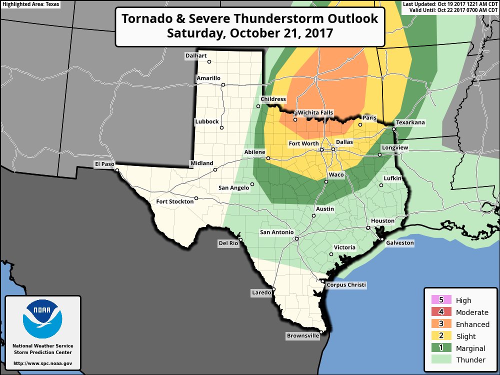
by cheezyWXguy
Is anyone going to talk about severe potential for Saturday? Seems like up until this morning it would be a marginal event at worst, and now portions of ntx are in an enhanced risk in the d3 outlook. FWD’s discussion this morning mentioned the potential for rotating storms ahead of the front in the early evening, and the afternoon discussion suggests discrete supercells are possible along and ahead of the front
Re: Texas Fall 2017
Posted: Thu Oct 19, 2017 9:10 pm
by bubba hotep
cheezyWXguy wrote:Is anyone going to talk about severe potential for Saturday? Seems like up until this morning it would be a marginal event at worst, and now portions of ntx are in an enhanced risk in the d3 outlook. FWD’s discussion this morning mentioned the potential for rotating storms ahead of the front in the early evening, and the afternoon discussion suggests discrete supercells are possible along and ahead of the front
I've been keeping an eye on it but haven't really posted anything, it looks like there will be a window of time for some discrete cells before the main line of storms moves in later in the evening. I wouldn't be surprised to see SPC expand things southward a bit with the update this evening. Here is the current D3:
Re: Texas Fall 2017
Posted: Thu Oct 19, 2017 9:31 pm
by starsfan65
bubba hotep wrote:cheezyWXguy wrote:Is anyone going to talk about severe potential for Saturday? Seems like up until this morning it would be a marginal event at worst, and now portions of ntx are in an enhanced risk in the d3 outlook. FWD’s discussion this morning mentioned the potential for rotating storms ahead of the front in the early evening, and the afternoon discussion suggests discrete supercells are possible along and ahead of the front
I've been keeping an eye on it but haven't really posted anything, it looks like there will be a window of time for some discrete cells before the main line of storms moves in later in the evening. I wouldn't be surprised to see SPC expand things southward a bit with the update this evening. Here is the current D3:
What is our window for severe storms for DFW?
Re: Texas Fall 2017
Posted: Thu Oct 19, 2017 9:36 pm
by Brent
starsfan65 wrote:bubba hotep wrote:cheezyWXguy wrote:Is anyone going to talk about severe potential for Saturday? Seems like up until this morning it would be a marginal event at worst, and now portions of ntx are in an enhanced risk in the d3 outlook. FWD’s discussion this morning mentioned the potential for rotating storms ahead of the front in the early evening, and the afternoon discussion suggests discrete supercells are possible along and ahead of the front
I've been keeping an eye on it but haven't really posted anything, it looks like there will be a window of time for some discrete cells before the main line of storms moves in later in the evening. I wouldn't be surprised to see SPC expand things southward a bit with the update this evening. Here is the current D3:
What is our window for severe storms for DFW?
looks like late afternoon/early evening for isolated cells, likely a squall line towards midnight
Re: Texas Fall 2017
Posted: Fri Oct 20, 2017 6:54 am
by srainhoutx
Gauges in and around Dickinson/League City in Galveston County are showing between 6 to 7 inches of rainfall in short order flooding streets.
Re: Texas Fall 2017
Posted: Fri Oct 20, 2017 6:59 am
by srainhoutx
Friday morning briefing from Jeff:
Heavy rainfall possible through the weekend.
Very active morning over portions of the area with intense short term rainfall rates. Clear Creek at Bay Area Blvd recorded nearly 7 inches in 2 hours.
Band of deep tropical moisture has pushed into the region from the SSW overnight along with a coastal trough that is lining up nicely with the current activity pushing out of the Gulf of Mexico. Radar returns show additional activity developing over the Gulf, but the short wave that helped to focus the heavy rainfall this morning is moving out of the area…so we should see a break through the mid to late morning hours.
Another weaker short wave will approach this afternoon and with surface heating will likely see additional showers and thunderstorms develop. Storm motions should be 10-15mph toward the NW, but any storm that anchors could produce very heavy rainfall in a short period of time.
Forecast for Saturday is more questionable as there does not appear to be any focus for storm development except heating and warm air advection. Will not rule out some sort of disturbance in the SW flow aloft that may ripple across the area and set off more scattered showers and thunderstorms.
Cold front will move across the region Saturday night and Sunday with showers and thunderstorms likely. Additional isolated heavy rainfall will be possible along this boundary as it crosses the region. Storm motions should be fast enough to preclude any flooding, but will have to keep an eye on any training cells.
Moisture levels clearly support excessive rainfall as shown this morning over S Harris/N Galveston Counties with 4-6 inches in an hour or two. Moisture levels will remain high today, then begin to decrease some on Saturday. Still a little nervous with the decent low level inflow, hard to time (and see) disturbances aloft, and potential for cells to anchor. Not expecting any sort of widespread flooding concerns, but isolated is possible.
Re: Texas Fall 2017
Posted: Fri Oct 20, 2017 9:02 am
by Ntxw
Look at what the CFS monthlies have trended for December. It fits the bill of front loaded via cold neutral-weak Nina climo. Focus the next 6 weeks should be the NPO (-EPO domain) as warming of the waters will result via the ridging to take place the coming days.

I'd hedge some bets we get some early dumps of shallow, arctic air. I'm also betting November might end up below normal...for once given it is likely to start out below normal.
Re: Texas Fall 2017
Posted: Fri Oct 20, 2017 11:37 am
by bubba hotep
12z GFS drops the hammer next Friday with temps falling into the 40s area wide by the afternoon!
Re: Texas Fall 2017
Posted: Fri Oct 20, 2017 11:42 am
by Brent
bubba hotep wrote:12z GFS drops the hammer next Friday with temps falling into the 40s area wide by the afternoon!
Snow in the Panhandle and maybe even as close as Oklahoma City


Re: Texas Fall 2017
Posted: Fri Oct 20, 2017 11:58 am
by gpsnowman
bubba hotep wrote:12z GFS drops the hammer next Friday with temps falling into the 40s area wide by the afternoon!
And it is only a week out!!!! Hope it holds.
Re: Texas Fall 2017
Posted: Fri Oct 20, 2017 12:00 pm
by Brent
at 384 hours(I know I know) the arctic unloads with freezing temperatures even in Dallas and temps well below zero in Montana and the Dakotas
Re: Texas Fall 2017
Posted: Fri Oct 20, 2017 12:12 pm
by Ralph's Weather
I like the consistency between the Euro and GFS for next Fri. Much is riding on how negative the EPO dives along with hoping that the PNA does not shoot too far positive. We want the West Coast ridge centered off of the coast otherwise it will the SE US enjoying the brunt of the cold. Shades of 2013 though this does not seem quite so extreme.
Re: Texas Fall 2017
Posted: Fri Oct 20, 2017 1:24 pm
by Ntxw
I do like how the North Pacific is behaving. Sure run to run long range may be crazy but it all follows suit with the hemispheric pattern shift we've been talking about for awhile. So while the individual cold snaps modeled may not be exact, the overall pattern is actually favorable for colder air to build and move. Slow step towards it.
It's cool to see the -EPO and -NAO regions work together
Re: Texas Fall 2017
Posted: Fri Oct 20, 2017 1:38 pm
by Brent
GFS/Euro look to be in pretty close agreement as the major front next Friday moves in
Euro has 50s during the daytime next Friday in DFW just like the GFS and some 30s outside DFW next Saturday morning. Actually has some rain with temps in the 40s
Re: Texas Fall 2017
Posted: Fri Oct 20, 2017 1:45 pm
by Ntxw
Here's the Typhoon (Lan) making it's way to Japan. It's quite large and will be absorbed by the trough coming out of East Asia. Recurve->pumps ridge in the Northeast Pacific
