
Texas Spring 2020
Moderator: S2k Moderators
Forum rules

The posts in this forum are NOT official forecast and should not be used as such. They are just the opinion of the poster and may or may not be backed by sound meteorological data. They are NOT endorsed by any professional institution or STORM2K.
-
TropicalTundra

- S2K Supporter

- Posts: 738
- Joined: Wed Oct 16, 2019 12:56 pm
- Location: Temple, Texas
Re: Texas Spring 2020
Is no one going to talk about the heat? It feels like summer! 
0 likes
Snow in Texas? What’s that?
Don't use my posts as forecast; I'm not a certified meteorologist! I just endorse cold weather, alright?
All observations I note are for Temple, Texas unless otherwise stated.

Re: Texas Spring 2020
TropicalTundra wrote:Is no one going to talk about the heat? It feels like summer!
It’s a dry heat here. I don’t have a problem with it. Feels fine to me.
1 likes
-
Brent
- S2K Supporter
- Posts: 38740
- Age: 37
- Joined: Sun May 16, 2004 10:30 pm
- Location: Tulsa Oklahoma
- Contact:
Re: Texas Spring 2020
Apparently the area around Paris is the new tornado alley while Dallas is sunny again
2 likes
#neversummer
-
bubba hotep

- S2K Supporter
- Posts: 6014
- Joined: Wed Dec 28, 2016 1:00 am
- Location: Collin County Texas
Re: Texas Spring 2020
Brent wrote:Apparently the area around Paris is the new tornado alley while Dallas is sunny again
I thought about heading up that way but decided to just view from the backyard and we did get some great cloud views. But now kind of kicking myself given that this was just under an hour away from the house lol
5 likes
Winter time post are almost exclusively focused on the DFW area.
-
bubba hotep
- S2K Supporter
- Posts: 6014
- Joined: Wed Dec 28, 2016 1:00 am
- Location: Collin County Texas
Re: Texas Spring 2020
Couple of more chances coming up.


2 likes
Winter time post are almost exclusively focused on the DFW area.
-
Texas Snowman

- Storm2k Moderator

- Posts: 6197
- Joined: Fri Jan 25, 2008 11:29 am
- Location: Denison, Texas
Re: Texas Spring 2020
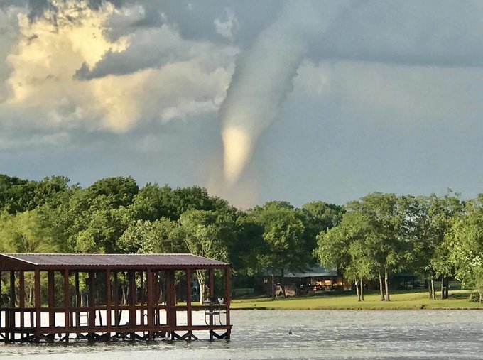
My son was out turkey hunting with a friend yesterday and this tornado formed almost on top of them. I’ve wanted to see a tornado for most of my 54 years, never have. He goes out turkey hunting and has one drop in his lap. 
https://twitter.com/z_burkhead/status/1253856918688468992
https://twitter.com/z_burkhead/status/1253856918688468992
5 likes
The above post and any post by Texas Snowman is NOT an official forecast and should not be used as such. It is just the opinion of the poster and may or may not be backed by sound meteorological data. It is NOT endorsed by any professional institution including storm2k.org. For official information, please refer to NWS products.
-
Texas Snowman
- Storm2k Moderator
- Posts: 6197
- Joined: Fri Jan 25, 2008 11:29 am
- Location: Denison, Texas
Re: Texas Spring 2020
His video was picked up by MSN and others...
https://twitter.com/z_burkhead/status/1253867230049288192
https://twitter.com/z_burkhead/status/1253867230049288192
5 likes
The above post and any post by Texas Snowman is NOT an official forecast and should not be used as such. It is just the opinion of the poster and may or may not be backed by sound meteorological data. It is NOT endorsed by any professional institution including storm2k.org. For official information, please refer to NWS products.
Re: Texas Spring 2020
The first part of May isn’t even looking that good for rain anymore across SETX 
0 likes

Re: Texas Spring 2020
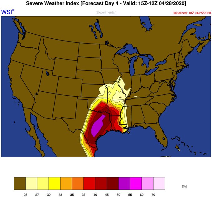
bubba hotep wrote:Couple of more chances coming up.
https://i.ibb.co/YTVfwCP/52820.png
https://www.cpc.ncep.noaa.gov/products/predictions/threats/hazards_d8_14_contours.png
It seems strange to me that Tuesday's set up is in a Northwest flow set-up. Isn't that usually more of a late spring, early summer set-up?
0 likes
-
bubba hotep
- S2K Supporter
- Posts: 6014
- Joined: Wed Dec 28, 2016 1:00 am
- Location: Collin County Texas

Re: Texas Spring 2020
Could you explain a little more what these maps are showing? To me they don’t quite make any sense.
0 likes
-
cheezyWXguy

- Category 5

- Posts: 6282
- Joined: Mon Feb 13, 2006 12:29 am
- Location: Dallas, TX
Re: Texas Spring 2020
18z nam has me wondering if tornado potential might sneak up on the dfw area, with the cold front to the north intersecting the dryline just the west. It shows SRH in the 200-300 m/s2 range for dfw at that time (hour 57). We’ll have to see if further runs show continuity.
0 likes

Re: Texas Spring 2020
We do likely have a better shot at some rainfall/thunderstorms compared to the past several systems for the metroplex. Not sure about an outbreak, NW flow aloft will favor MCS activity but we'll have to wait and see as the time comes closer. I would favor a round or two of a line coming through. Strong winds, small hail, lightning being the biggest players.
Same will go for Central and parts of SE Texas.
Same will go for Central and parts of SE Texas.
5 likes
The above post and any post by Ntxw is NOT an official forecast and should not be used as such. It is just the opinion of the poster and may or may not be backed by sound meteorological data. It is NOT endorsed by any professional institution including Storm2k. For official information, please refer to NWS products.
Help support Storm2K!
-
cheezyWXguy
- Category 5
- Posts: 6282
- Joined: Mon Feb 13, 2006 12:29 am
- Location: Dallas, TX
Re: Texas Spring 2020
cheezyWXguy wrote:18z nam has me wondering if tornado potential might sneak up on the dfw area, with the cold front to the north intersecting the dryline just the west. It shows SRH in the 200-300 m/s2 range for dfw at that time (hour 57). We’ll have to see if further runs show continuity.
I had this wrong about the dryline, it’s further out in west Texas. This appears to be some other boundary, probably spit out by a portion of the line to the west of dfw surging southward faster than the rest of the line.
1 likes
-
wxman22

- Category 5
- Posts: 1920
- Joined: Mon Jan 30, 2006 12:39 am
- Location: Wichita Falls, TX
- Contact:
Re: Texas Spring 2020

Day 2 Convective Outlook
NWS Storm Prediction Center Norman OK
0100 AM CDT Mon Apr 27 2020
Valid 281200Z - 291200Z
...THERE IS AN ENHANCED RISK OF SEVERE THUNDERSTORMS ACROSS PARTS OF
THE SOUTHERN PLAINS INTO THE OZARKS AND ARKLATEX...
...SUMMARY...
Scattered to numerous severe thunderstorms are expected Tuesday
across parts of the southern/central Plains into the lower/mid
Mississippi Valley and Midwest. Scattered large to very large hail,
numerous severe wind gusts (some significant), and a few tornadoes
may occur.
...Southern Plains into the ArkLaTex and Lower Mississippi Valley...
A shortwave trough will dig southeastward from the northern
Rockies/Plains to the MS Valley on Tuesday. As it does so, a surface
low is forecast to develop eastward across the Upper Midwest to
southern WI by Tuesday evening. Low-level moisture return will occur
in earnest across the southern Plains into parts of the ArkLaTex,
with mid 60s to low 70s surface dewpoints becoming common. A surface
dryline will extend southward from a thermal low across the southern
High Plains, and steep mid-level lapse rates will be present over
much of the warm sector. With ample diurnal heating expected,
moderate to very strong instability (MLCAPE 2000-4000 J/kg) appears
likely to develop by peak afternoon heating. Convection will quickly
form and then explosively strengthen along a southeastward-moving
cold front across southern KS/northern OK by late Tuesday afternoon,
with initiation along the dryline more uncertain given at least some
residual low-level capping.
Although low-level flow is not forecast to be particularly strong,
mid/upper-level northwesterly winds will strengthen through the late
afternoon into the overnight as the shortwave trough shifts
southeastward. Effective bulk shear is likewise forecast to increase
sufficiently to support supercells with initial development along
the cold front. Scattered large to very large hail will likely be
the main threat so long as storms can remain semi-discrete. By early
evening, upscale growth along the front will likely occur, with one
or more bowing segments moving quickly southeastward across parts of
central/eastern OK into north-central/northeast TX and the ArkLaTex
region. Although convective inhibition will increase some through
the evening, the well organized nature of the convection and large
instability reservoir will likely support a swath of numerous to
potentially widespread damaging winds, some of which could be
significant. A tornado or two also cannot be ruled out. Eventually,
the line should weaken with southward extent into the lower MS
Valley and coastal TX as it outpaces the stronger shear/forcing
associated with the shortwave trough.
...Central Plains/Ozarks into the Mid Mississippi Valley and
Midwest...
Latest guidance has come into better agreement with the evolution of
the surface low and potential for more robust instability to develop
across parts of the mid MS Valley by Tuesday afternoon. Both
low-level flow and shear should be somewhat stronger across this
region compared to locations farther south. At least semi-discrete
supercells appear probable from portions of southeastern IA into
northern/central MO and IL. At least isolated large hail may occur,
along with some damaging winds if storms can grow upscale into one
or more small clusters. A few tornadoes also appear possible from
late Tuesday afternoon through early evening along/south of the warm
front given a favorable storm mode and sufficient low-level shear.
By late Tuesday evening into the overnight hours, storms should
weaken as they encounter a less unstable airmass over parts of the
Mid-South and western KY/IN.
..Gleason.. 04/27/2020
1 likes
-
vbhoutex

- Storm2k Executive

- Posts: 29147
- Age: 74
- Joined: Wed Oct 09, 2002 11:31 pm
- Location: Cypress, TX
- Contact:
Re: Texas Spring 2020
Jeff Lindner's take on tomorrow'a possible severe weather for SE TX.
Another spring storm system will bring a round of thunderstorms across SE TX later Tuesday-early Wednesday.
Another storm system will move across the southern plains during the middle of this week before the sub-tropical ridge that has been baking the Gulf of Mexico begins to shift northward some this weekend…a potential harbinger of summer weather. Surface low pressure will be developing over the southern plains over the next 24 hours and southerly winds (gusty at times) have already returned to the region. These south winds will begin to transport moisture back into the region and by Tuesday afternoon a fairly moist and unstable air mass will be in place. Cap will remain strong into at least Tuesday afternoon and then begin to weaken some. Expect most of Tuesday to remain dry, although a few showers cannot be ruled out north of a line from Columbus to Liberty.
As the surface low begins to move eastward across OK Tuesday night a front will drag SE toward and across the region. Numerous thunderstorms are expected to develop along this boundary and move S/SE Tuesday night into Wednesday morning. Models are showing a fairly favorable damaging wind profile over the NE 1/3rd of the region early Wednesday morning as what appears to be a bowing line segment moves from roughly the Huntsville area toward Liberty or generally across the Lake Livingston region. Capping does increase toward the south and west, so there is little confidence on how much development there will be toward the Matagorda Bay region and down along the coast from Galveston westward.
Line of thunderstorms should be approaching the region after midnight and reach the I-10 corridor from Houston eastward before sunrise. Strong winds will be the main threats with these storms with hail and tornadoes more isolated concerns.
After these storms move through the region early Wednesday, high pressure begins to build northward from the Gulf of Mexico. Strong subsidence is expected Thursday-weekend with high temperatures pushing into the lower 90’s. Southerly winds return by Thursday evening and dewpoints are back into the mid to upper 60’s by Friday so heat index values this upcoming weekend could be well into the 90’s to near 100.
1 likes
Skywarn, C.E.R.T.
Please click below to donate to STORM2K to help with the expenses of keeping the site going:

Please click below to donate to STORM2K to help with the expenses of keeping the site going:

Re: Texas Spring 2020
Looking interesting today. Moderate just to the East and a nasty cell headed straight at me now..
0 likes
-
TheProfessor

- Professional-Met

- Posts: 3506
- Age: 29
- Joined: Tue Dec 03, 2013 10:56 am
- Location: Wichita, Kansas
Re: Texas Spring 2020
Not a good night to have a DFW radio station on.
0 likes
An alumnus of The Ohio State University.
Your local National Weather Service office is your best source for weather information.
Your local National Weather Service office is your best source for weather information.
-
rwfromkansas
- Category 5
- Posts: 3032
- Joined: Sat Aug 27, 2005 12:47 am
- Location: North Fort Worth
Re: Texas Spring 2020
Got woken up by a surprise storm and hail but got over an inch out of it.
About marble size, so big enough to be a bit scary.
About marble size, so big enough to be a bit scary.
1 likes
Re: Texas Spring 2020
Had between Quarter to Half dollar hail here in Arlington.
Last edited by EnnisTx on Tue Apr 28, 2020 9:22 am, edited 3 times in total.
0 likes
Return to “USA & Caribbean Weather”
Who is online
Users browsing this forum: Google Adsense [Bot] and 30 guests