Texas Fall 2017

U.S. & Caribbean Weather Discussions and Severe Weather Events

Moderator: S2k Moderators

Forum rules

The posts in this forum are NOT official forecast and should not be used as such. They are just the opinion of the poster and may or may not be backed by sound meteorological data. They are NOT endorsed by any professional institution or STORM2K.

Help Support Storm2K
Message
Author
User avatar
CaptinCrunch
S2K Supporter
S2K Supporter
Posts: 8580
Age: 56
Joined: Mon Nov 03, 2003 4:33 pm
Location: Lake Worth, TX (Tarrant Co.)

Re: Texas Fall 2017

#501 Postby CaptinCrunch » Fri Oct 20, 2017 1:50 pm

Image

Image

Seems to be more Ice Pack but less snow cover compared to the same date 2016 :cold:
0 likes   

Tejas89
Category 1
Category 1
Posts: 415
Joined: Mon Dec 28, 2009 9:25 pm
Location: DFW, TX

Re: Texas Fall 2017

#502 Postby Tejas89 » Fri Oct 20, 2017 2:53 pm

FWD mentions a front next Thursday night. Interested to see the afternoon discussion.

2/3 through, October is running about 5F above normal.
0 likes   

Ntxw
Storm2k Moderator
Storm2k Moderator
Posts: 21565
Joined: Wed Oct 21, 2009 6:34 pm
Location: DFW, Texas

Re: Texas Fall 2017

#503 Postby Ntxw » Fri Oct 20, 2017 2:59 pm

Tejas89 wrote:FWD mentions a front next Thursday night. Interested to see the afternoon discussion.

2/3 through, October is running about 5F above normal.


October is a lock to be above normal. We may get it down to 2-3F above with the coming cool spells but lows are not on par to what they should be. We likely won't top 1963 and 2016 for top two spots but a top 5 finish could happen.
0 likes   
The above post and any post by Ntxw is NOT an official forecast and should not be used as such. It is just the opinion of the poster and may or may not be backed by sound meteorological data. It is NOT endorsed by any professional institution including Storm2k. For official information, please refer to NWS products.

  Help support Storm2K!
Help Support Storm2K

Brent
S2K Supporter
S2K Supporter
Posts: 37143
Age: 35
Joined: Sun May 16, 2004 10:30 pm
Location: Tulsa Oklahoma
Contact:

Re: Texas Fall 2017

#504 Postby Brent » Fri Oct 20, 2017 3:32 pm

Ntxw wrote:
Tejas89 wrote:FWD mentions a front next Thursday night. Interested to see the afternoon discussion.

2/3 through, October is running about 5F above normal.


October is a lock to be above normal. We may get it down to 2-3F above with the coming cool spells but lows are not on par to what they should be. We likely won't top 1963 and 2016 for top two spots but a top 5 finish could happen.


I'm just encouraged we're getting good fronts earlier than last year.... Halloween may actually be pretty amazing(not cold but not hot either) if the current forecasts hold.

FWD AFD:

Next week looks really nice with a
reinforcing shot of cooler air moving through on Monday night.
This front should come through precipitation free. We`ll see a
slight warm up through mid week, then a much stronger front will
move through the Plains on Thursday evening. This could mean a
significantly cooler weekend next weekend.


also about the severe weather tomorrow:

Later Saturday evening into the nighttime hours as stronger height
falls overspread North Texas, thunderstorms are expected to be
ongoing along and ahead of the cold front across parts of
Oklahoma. These storms will continue to rapidly develop southward
along the front and will be developing in an unstable
environment. Given the available instability and strong forcing
for ascent, thunderstorms should be able to maintain vigorous
updrafts rooted in the warm sector. This suggests that a well
organized squall line accompanied by a damaging wind threat
should develop and be in progress prior to midnight across parts
of North Texas. Low level shear will be sufficient for a few
bowing segments and possibly a few QLCS tornadoes well into the
late evening and overnight hours.
Hail will be a threat especially
in the evening hours on Saturday and with initial thunderstorm
development, but the main threat should transition into a damaging
wind threat later into the evening hours.
0 likes   
#neversummer

Ntxw
Storm2k Moderator
Storm2k Moderator
Posts: 21565
Joined: Wed Oct 21, 2009 6:34 pm
Location: DFW, Texas

Re: Texas Fall 2017

#505 Postby Ntxw » Fri Oct 20, 2017 4:30 pm

Should be warm tomorrow (for late October) some places high 80s ahead of the line of storms. Most guidance agree on 1-3" of rain, closer to 1" I-35 on west and closer to 3" I-35 on east. Northeast burbs may be highest winners in rainfall department. 60s mostly on Sunday for highs. Timing a few hours later for central and SE Texas closer to morning Sunday.

3km +/- close to midnight tomorrow

Image

The NAM unlike the globals do cut the low off for a while bringing back some showers as it passes by. This solution would yield cooler and damp for Sunday than forecast.
1 likes   
The above post and any post by Ntxw is NOT an official forecast and should not be used as such. It is just the opinion of the poster and may or may not be backed by sound meteorological data. It is NOT endorsed by any professional institution including Storm2k. For official information, please refer to NWS products.


  Help support Storm2K!

Help Support Storm2K


Ntxw
Storm2k Moderator
Storm2k Moderator
Posts: 21565
Joined: Wed Oct 21, 2009 6:34 pm
Location: DFW, Texas

Re: Texas Fall 2017

#506 Postby Ntxw » Fri Oct 20, 2017 5:14 pm

That is an awesome trough pattern late next week. Only thing missing (1993 had) is a SW cutoff low

Image

Image
2 likes   
The above post and any post by Ntxw is NOT an official forecast and should not be used as such. It is just the opinion of the poster and may or may not be backed by sound meteorological data. It is NOT endorsed by any professional institution including Storm2k. For official information, please refer to NWS products.


  Help support Storm2K!

Help Support Storm2K


Brent
S2K Supporter
S2K Supporter
Posts: 37143
Age: 35
Joined: Sun May 16, 2004 10:30 pm
Location: Tulsa Oklahoma
Contact:

Re: Texas Fall 2017

#507 Postby Brent » Fri Oct 20, 2017 11:50 pm

0z GFS is pretty crazy the day after Halloween, first day of November, a snowstorm in Oklahoma and a cold rain and low 40s in DFW
0 likes   
#neversummer

User avatar
srainhoutx
S2K Supporter
S2K Supporter
Posts: 6919
Age: 66
Joined: Sun Jan 14, 2007 11:34 am
Location: Haywood County, NC
Contact:

Re: Texas Fall 2017

#508 Postby srainhoutx » Sat Oct 21, 2017 9:47 am

Impressive Blocking Regime via the 00Z ECMWF EPS at hour 168 and 192. Typhoon Lan is going to shuffle the stagnant Hemispheric Pattern ushering in a deep and cold full latitude trough next weekend. Stepping down... :wink:
3 likes   
Carla/Alicia/Jerry(In The Eye)/Michelle/Charley/Ivan/Dennis/Katrina/Rita/Wilma/Ike/Harvey

Member: National Weather Association
Wx Infinity Forums
http://wxinfinity.com/index.php

Facebook.com/WeatherInfinity
Twitter @WeatherInfinity

Brent
S2K Supporter
S2K Supporter
Posts: 37143
Age: 35
Joined: Sun May 16, 2004 10:30 pm
Location: Tulsa Oklahoma
Contact:

Re: Texas Fall 2017

#509 Postby Brent » Sat Oct 21, 2017 1:32 pm

12z Euro back to blasting the front through Friday in DFW... the morning starts around 65 and is in the low 50s by lunch and mid 40s by 0z.

Saturday's high struggles to 50. Probably a cold dreary day.

Has upper 30s even in DFW next Sunday morning
Last edited by Brent on Sat Oct 21, 2017 1:49 pm, edited 3 times in total.
1 likes   
#neversummer

Ntxw
Storm2k Moderator
Storm2k Moderator
Posts: 21565
Joined: Wed Oct 21, 2009 6:34 pm
Location: DFW, Texas

Re: Texas Fall 2017

#510 Postby Ntxw » Sat Oct 21, 2017 1:39 pm

850mb temps are approaching 0C on the Euro. Would likely be a frost/freeze threat (especially outside the urban corridors) for many.
1 likes   
The above post and any post by Ntxw is NOT an official forecast and should not be used as such. It is just the opinion of the poster and may or may not be backed by sound meteorological data. It is NOT endorsed by any professional institution including Storm2k. For official information, please refer to NWS products.


  Help support Storm2K!

Help Support Storm2K


gpsnowman
S2K Supporter
S2K Supporter
Posts: 2733
Joined: Fri Jan 07, 2011 10:35 am
Location: Grand Prairie Tx

Re: Texas Fall 2017

#511 Postby gpsnowman » Sat Oct 21, 2017 5:51 pm

The Farmers Almanac outlook for November. :cold: :double:
1st-3rd.
Widespread stormy weather.
4th-7th.
Fair/cold weather.
8th-11th.
Light snow or rain followed by clearing.
12th-15th.
Stormy again.
16th-19th.
Storms clear away to the East; then colder.
20th-23rd.
Unsettled for Thanksgiving. Snow for parts of New Mexico and West Texas; wintry mix for the rest of Texas/Oklahoma, and much of Arkansas. Cold rain Texas/Louisiana Coast.
24th-27th.
Fair followed by a significant snow for the high terrain of New Mexico, northern Texas/Oklahoma.
28th-30th.
Snow continues to fall and accumulate
2 likes   

gpsnowman
S2K Supporter
S2K Supporter
Posts: 2733
Joined: Fri Jan 07, 2011 10:35 am
Location: Grand Prairie Tx

Re: Texas Fall 2017

#512 Postby gpsnowman » Sat Oct 21, 2017 5:53 pm

20th-23rd.
Rain/thunderstorms for Texas and points east, followed by clearing/colder weather.
24th-27th.
Fair skies change to unsettled conditions; light rain for Texas and points east.
28th-31st.
Increasing cloudiness; very unsettled conditions spread in from New Mexico

For the rest of October. Looks like they nailed the 20th-23rd.
0 likes   

gpsnowman
S2K Supporter
S2K Supporter
Posts: 2733
Joined: Fri Jan 07, 2011 10:35 am
Location: Grand Prairie Tx

Re: Texas Fall 2017

#513 Postby gpsnowman » Sat Oct 21, 2017 6:18 pm

Radar starting to light up in west Texas and Oklahoma. Can not wait for the storms, too bad they will come across in the middle of the night. If I am awakened by them, I might just stay up and watch the show.
0 likes   

User avatar
gboudx
S2K Supporter
S2K Supporter
Posts: 4047
Joined: Thu Sep 04, 2003 1:39 pm
Location: Rockwall, Tx but from Harvey, La

Re: Texas Fall 2017

#514 Postby gboudx » Sat Oct 21, 2017 6:48 pm

20th-23rd.
Unsettled for Thanksgiving. Snow for parts of New Mexico and West Texas; wintry mix for the rest of Texas/Oklahoma, and much of Arkansas. Cold rain Texas/Louisiana Coast.
24th-27th.
Fair followed by a significant snow for the high terrain of New Mexico, northern Texas/Oklahoma.
28th-30th.
Snow continues to fall and accumulate.

I can't think of much better Thanksgiving weather. Cold outside, fire roaring in the fireplace, sleeping off the turkey coma.
0 likes   

Brent
S2K Supporter
S2K Supporter
Posts: 37143
Age: 35
Joined: Sun May 16, 2004 10:30 pm
Location: Tulsa Oklahoma
Contact:

Re: Texas Fall 2017

#515 Postby Brent » Sat Oct 21, 2017 7:03 pm

gpsnowman wrote:The Farmers Almanac outlook for November. :cold: :double:
1st-3rd.
Widespread stormy weather.
4th-7th.
Fair/cold weather.
8th-11th.
Light snow or rain followed by clearing.
12th-15th.
Stormy again.
16th-19th.
Storms clear away to the East; then colder.
20th-23rd.
Unsettled for Thanksgiving. Snow for parts of New Mexico and West Texas; wintry mix for the rest of Texas/Oklahoma, and much of Arkansas. Cold rain Texas/Louisiana Coast.
24th-27th.
Fair followed by a significant snow for the high terrain of New Mexico, northern Texas/Oklahoma.
28th-30th.
Snow continues to fall and accumulate


if this verifies I could live with a sucky winter :lol:
0 likes   
#neversummer

User avatar
starsfan65
Category 2
Category 2
Posts: 675
Age: 46
Joined: Thu Dec 17, 2015 1:18 pm
Location: Garland,Tx

Re: Texas Fall 2017

#516 Postby starsfan65 » Sat Oct 21, 2017 7:07 pm

Brent wrote:
gpsnowman wrote:The Farmers Almanac outlook for November. :cold: :double:
1st-3rd.
Widespread stormy weather.
4th-7th.
Fair/cold weather.
8th-11th.
Light snow or rain followed by clearing.
12th-15th.
Stormy again.
16th-19th.
Storms clear away to the East; then colder.
20th-23rd.
Unsettled for Thanksgiving. Snow for parts of New Mexico and West Texas; wintry mix for the rest of Texas/Oklahoma, and much of Arkansas. Cold rain Texas/Louisiana Coast.
24th-27th.
Fair followed by a significant snow for the high terrain of New Mexico, northern Texas/Oklahoma.
28th-30th.
Snow continues to fall and accumulate


if this verifies I could live with a sucky winter :lol:
U don't think it will verify?
0 likes   

Brent
S2K Supporter
S2K Supporter
Posts: 37143
Age: 35
Joined: Sun May 16, 2004 10:30 pm
Location: Tulsa Oklahoma
Contact:

Re: Texas Fall 2017

#517 Postby Brent » Sat Oct 21, 2017 7:26 pm

starsfan65 wrote:
Brent wrote:
gpsnowman wrote:The Farmers Almanac outlook for November. :cold: :double:
1st-3rd.
Widespread stormy weather.
4th-7th.
Fair/cold weather.
8th-11th.
Light snow or rain followed by clearing.
12th-15th.
Stormy again.
16th-19th.
Storms clear away to the East; then colder.
20th-23rd.
Unsettled for Thanksgiving. Snow for parts of New Mexico and West Texas; wintry mix for the rest of Texas/Oklahoma, and much of Arkansas. Cold rain Texas/Louisiana Coast.
24th-27th.
Fair followed by a significant snow for the high terrain of New Mexico, northern Texas/Oklahoma.
28th-30th.
Snow continues to fall and accumulate


if this verifies I could live with a sucky winter :lol:
U don't think it will verify?


I mean you never know it could but the Farmers Almanac isn't guaranteed to be right

Snow in November is a lot harder to get too

But I'd love to see it

I will say I do like the pattern generally coming but we still live in a place where snow isn't guaranteed
0 likes   
#neversummer

User avatar
bubba hotep
S2K Supporter
S2K Supporter
Posts: 5609
Joined: Wed Dec 28, 2016 1:00 am
Location: Collin County Texas

Re: Texas Fall 2017

#518 Postby bubba hotep » Sat Oct 21, 2017 8:48 pm

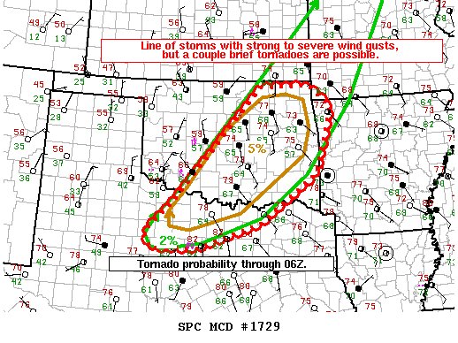
Image

Mesoscale Discussion 1729
NWS Storm Prediction Center Norman OK
0834 PM CDT Sat Oct 21 2017

Areas affected...Central/eastern OK and north TX

Concerning...Tornado Watch 503...504...

Valid 220134Z - 220300Z

The severe weather threat for Tornado Watch 503, 504 continues.

SUMMARY...Primary hazard should be strong to severe wind gusts with
an accelerating line of storms moving east, but a couple brief
tornadoes will remain possible within embedded mesovortices.

DISCUSSION...An extensive QLCS extends from southeast MN into
northwest TX. Strong to severe wind gusts of 45-60 mph have been
common per OK Mesonet sites. This should remain the primary hazard
as the line progresses east in tandem with a convectively reinforced
cold front, likely reaching the Tulsa metro area around 10 pm. With
surface dew points in the middle 60s and 0-1 km SRH around 300 m2/s2
per TLX/INX VWP data, transient mesovortices will pose a risk for a
couple brief tornadoes along the line. The progressive, surging
nature of the composite outflow/front should mitigate a greater
tornado threat.

..Grams.. 10/22/2017

...Please see www.spc.noaa.gov for graphic product...

ATTN...WFO...SGF...SHV...TSA...FWD...OUN...SJT...
0 likes   
Winter time post are almost exclusively focused on the DFW area.

Brent
S2K Supporter
S2K Supporter
Posts: 37143
Age: 35
Joined: Sun May 16, 2004 10:30 pm
Location: Tulsa Oklahoma
Contact:

Re: Texas Fall 2017

#519 Postby Brent » Sat Oct 21, 2017 11:02 pm

didn't even notice DFW hit 90 today. :roll: Hopefully the last one for at least 7 months.
0 likes   
#neversummer

Brent
S2K Supporter
S2K Supporter
Posts: 37143
Age: 35
Joined: Sun May 16, 2004 10:30 pm
Location: Tulsa Oklahoma
Contact:

Re: Texas Fall 2017

#520 Postby Brent » Sun Oct 22, 2017 1:36 am

0z Euro has a lot of cold rain(over an inch) Friday Night into Saturday in DFW, temperatures in the 40s most of the day Saturday :cold:

Could be our first winter tease :lol:

Cold would peak Saturday and Sunday then gradually warmup

Early look at Halloween it appears temperatures will moderate some by then(Euro is in the 60s for highs, GFS well into the 70s)
0 likes   
#neversummer


Return to “USA & Caribbean Weather”

Who is online

Users browsing this forum: Cpv17 and 54 guests