Link: http://www.weather.gov/data/obhistory/KMIA.html
Yet another 90 degree day in Miami
Florida Weather
Moderator: S2k Moderators
Forum rules

The posts in this forum are NOT official forecast and should not be used as such. They are just the opinion of the poster and may or may not be backed by sound meteorological data. They are NOT endorsed by any professional institution or STORM2K.
-
tropicana

- Category 5

- Posts: 8056
- Joined: Sat Sep 27, 2003 6:48 pm
- Location: Niagara Falls, Ontario, Canada
- Contact:
Re:
HURAKAN wrote:Link: http://www.weather.gov/data/obhistory/KMIA.html
Yet another 90 degree day in Miami
thats the 11th cons. day of 90F or better at Miami (Oct 5-15) and 12th 90 degree day in Miami this month (which includes Oct 3).
0 likes
-
JonathanBelles
- Professional-Met

- Posts: 11430
- Age: 35
- Joined: Sat Dec 24, 2005 9:00 pm
- Location: School: Florida State University (Tallahassee, FL) Home: St. Petersburg, Florida
- Contact:
-
JonathanBelles
- Professional-Met
- Posts: 11430
- Age: 35
- Joined: Sat Dec 24, 2005 9:00 pm
- Location: School: Florida State University (Tallahassee, FL) Home: St. Petersburg, Florida
- Contact:


-
HURAKAN

- Professional-Met
- Posts: 46084
- Age: 38
- Joined: Thu May 20, 2004 4:34 pm
- Location: Key West, FL
- Contact:
RECORD EVENT REPORT
NATIONAL WEATHER SERVICE MIAMI, FL
130 PM EDT FRI OCT 16 2009
...RECORD HIGH TEMPERATURE SET AT MIAMI...
THE HIGH TEMPERATURE AT MIAMI INTERNATIONAL AIRPORT SO FAR TODAY IS
94 DEGREES. THIS BREAKS THE OLD RECORD OF 90 SET IN 1989. ANOTHER
UPDATE WILL BE PROVIDED LATER IN THE AFTERNOON.
RECORD EVENT REPORT...CORRECTED
NATIONAL WEATHER SERVICE MIAMI, FL
130 PM EDT FRI OCT 16 2009
...RECORD HIGH TEMPERATURE TIED AT WEST PALM BEACH...
THE HIGH TEMPERATURE AT WEST PALM BEACH SO FAR TODAY IS 92 DEGREES.
THIS TIES THE RECORD SET BACK IN 1911. AN UPDATE WILL BE PROVIDED
LATER IN THE AFTERNOON.
RECORD EVENT REPORT
NATIONAL WEATHER SERVICE MELBOURNE
810 AM EDT FRI OCT 16 2009
...RECORD HIGH TEMPERATURE SET AT VERO BEACH YESTERDAY...
A RECORD HIGH TEMPERATURE OF 94 DEGREES WAS SET AT VERO BEACH
YESTERDAY, THURSDAY, OCTOBER 15TH. THIS BREAKS THE OLD RECORD OF 90 SET
IN 2002.
0 likes
-
JonathanBelles
- Professional-Met
- Posts: 11430
- Age: 35
- Joined: Sat Dec 24, 2005 9:00 pm
- Location: School: Florida State University (Tallahassee, FL) Home: St. Petersburg, Florida
- Contact:


Re: Florida Weather Thread: Wetter & Cooler this winter
AREA FORECAST DISCUSSION
NATIONAL WEATHER SERVICE JACKSONVILLE FL
925 AM EDT SAT OCT 17 2009
...NEAR RECORD MINIMUM MAX TEMPS TODAY AND SUNDAY...
.SYNOPSIS...THE AIRMASS HAS DRAMATICALLY CHANGED COMPARED TO 24 HRS
AGO FOLLOWING THE PASSAGE OF THIS SEASONS FIRST SIGNIFICANT FRONTAL
PASSAGE. THE COLD FRONT NOW EXTENDS ACROSS SOUTH FL...WITH A SECOND
BOUNDARY EDGING SOUTHWARD FROM SOUTHERN SC INTO TN. A 1028 MB
SURFACE HIGH WAS EDGING SSE FROM THE NORTHERN PLAINS...WHILE ALOFT A
DEEP UPPER LEVEL TROUGH WAS STILL FILLING WITH AN AXIS PIVOTING
DOWNSTREAM OF THE MS RIVER VALLEY. LOCALLY...THE 12Z JAX RAOB SHOWED
OVER 15 DEG OF COOLING BETWEEN 1000 AND 900 MB WITH STRONG
SUBSIDENCE ABOVE 900 MB.
.FOR THE UPDATE...ADJUSTED CLOUD WORDING A BIT AS WELL AS LOWERED
MAX TEMPS DUE TO RECENT OBS RUNNING A COUPLE DEGS BELOW HOURLY
GUIDANCE VALUES. AS THE SECOND TROUGH TO OUR NORTH ROTATES SOUTHWARD
THIS AFTN...EXPECT SOME LOW LEVEL CU TO FILTER SOUTH OF THE ALTAMAHA
RIVER BASIN BRINGING PARTLY CLOUDY CONDITIONS TO OUR NORTHERN ZONES.
ALSO INCLUDED MARGINAL BREEZY CONDITIONS FOR OUR FL ZONES CAPPING
WINDS AT 15 MPH. MAX TEMPS WILL NEAR 60 ACROSS INLAND SE GA...TO
ONLY THE UPPER 60S ACROSS OUR SOUTHERN TIER. THESE VALUES WILL
CHALLENGE RECORD LOW MAX TEMPS TODAY AND POSSIBLY TOMORROW AS WELL:
RECORD MINIMUM MAX TEMPS TODAY (10/17) AND TOMORROW (10/18):
SITE 10/17 10/18
AMG 66/1997 64/1997
SSI 64/2001 62/1976
JAX 62/1940 65/1978
GNV 67/1956 68/1997
Currently 54F, and we won't see 70F today or tomorrow at all, maybe Monday. Lower 40s forecast so far.
Nice change of weather.
0 likes
-
HURAKAN
- Professional-Met
- Posts: 46084
- Age: 38
- Joined: Thu May 20, 2004 4:34 pm
- Location: Key West, FL
- Contact:
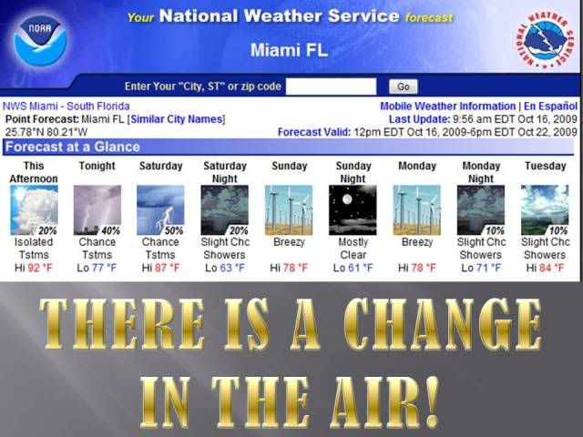
And why not another 90 degree day in Miami!!!
Link: http://forecast.weather.gov/MapClick.ph ... =-80.2&e=1
Link: http://forecast.weather.gov/MapClick.ph ... =-80.2&e=1
0 likes
-
HURAKAN
- Professional-Met
- Posts: 46084
- Age: 38
- Joined: Thu May 20, 2004 4:34 pm
- Location: Key West, FL
- Contact:
Re: Florida Weather Thread: Wetter & Cooler this winter
NEW RECORD: 91ºF
RECORD EVENT REPORT
NATIONAL WEATHER SERVICE MIAMI, FL
1130 AM EDT SAT OCT 17 2009
...RECORD HIGH TEMPERATURE TIED AT MIAMI...
THE HIGH TEMPERATURE AT MIAMI INTERNATIONAL AIRPORT SO FAR TODAY IS 90 DEGREES.
THIS TIES THE RECORD SET BACK IN 1947. AN UPDATE WILL BE PROVIDED
LATER IN THE AFTERNOON.
RECORD EVENT REPORT
NATIONAL WEATHER SERVICE MIAMI, FL
1130 AM EDT SAT OCT 17 2009
...RECORD HIGH TEMPERATURE TIED AT MIAMI...
THE HIGH TEMPERATURE AT MIAMI INTERNATIONAL AIRPORT SO FAR TODAY IS 90 DEGREES.
THIS TIES THE RECORD SET BACK IN 1947. AN UPDATE WILL BE PROVIDED
LATER IN THE AFTERNOON.
0 likes
Re: Florida Weather Thread: Wetter & Cooler this winter
Marks day #14 this month of 90+ deg in Miami......blows the old record of most 90+ deg days of 9 out of the water....month is running 5.1 deg above normal in Miami.
HURAKAN wrote:NEW RECORD: 91ºF
RECORD EVENT REPORT
NATIONAL WEATHER SERVICE MIAMI, FL
1130 AM EDT SAT OCT 17 2009
...RECORD HIGH TEMPERATURE TIED AT MIAMI...
THE HIGH TEMPERATURE AT MIAMI INTERNATIONAL AIRPORT SO FAR TODAY IS 90 DEGREES.
THIS TIES THE RECORD SET BACK IN 1947. AN UPDATE WILL BE PROVIDED
LATER IN THE AFTERNOON.
0 likes
Re: Florida Weather Thread: Wetter & Cooler this winter
Through October 16th, the average temp in Miami month-to-date is 84.9 deg. The all-time record for the warmest October is 82.0 deg, set in 2002. Even with a brief cooldown, followed by near-normal temps, the previous all-time record is on track to be beaten this month.
From latest NWS Miami Discussion...
RELATIVE HUMIDITIES WILL ALSO BE MUCH LOWER ON SUNDAY SO A NICE
WAY TO AT LEAST TEMPORARILY STOP THE RAINY SEASON. THE MID LEVEL
TROUGH WILL THEN RAPIDLY SHIFT NORTHEAST ON MONDAY WHICH WILL ALSO
FORCE THE SURFACE RIDGE INTO THE ATLANTIC. THIS WILL VEER THE WIND
TO A MORE EASTERLY DIRECTION AND TEMPERATURES WILL BEGIN TO MODIFY
AND BE BACK TO SEASONAL NORMALS BY TUESDAY OR WEDNESDAY CONTINUING
THROUGH THE REMAINDER OF THE WEEK. ALSO, WITH A RETURN FLOW OFF
THE ATLANTIC THERE MAY BE SOME ISOLATED SHOWERS ALONG THE EAST
COAST BY MONDAY NIGHT AND CONTINUING THROUGH THE WEEK. THIS WILL
ALSO RESULT IN MORE HUMID CONDITIONS BY THE MIDDLE OF THIS NEXT
WEEK. SO ENJOY THE NICE COOL SPELL WHILE YOU CAN.
0 likes
Re: Florida Weather Thread: Wetter & Cooler this winter
A wonderful taste of fall....temps are downright chilly by local standards this morning...upper 50's to low 60's across most areas of miami-dade and broward....it is nice to turn the a/c off. The chill is short-lived.....once winds turn to the ne on monday, the temps will rebound. Hot/humid again by the end of the upcoming week.
NWS Zone Forecast for: Coastal Broward County & Miami Dade County, FL
Issued by: National Weather Service Miami - South Florida
Last Update: 342 AM EDT SUN OCT 18 2009
--------------------------------------------------------------------------------
Today...Partly sunny in the morning then becoming mostly sunny. Much cooler. Highs in the mid 70s.
Tonight...Mostly clear. Lows 58 to 62. North winds 10 to 15 mph.
Monday...Mostly sunny...then partly sunny. Breezy. Highs in the upper 70s.
Monday Night...Partly cloudy with a 20 percent chance of showers. Not as cool. Lows in the lower 70s.
Tuesday...Partly sunny with a 20 percent chance of showers. Windy. Highs in the lower 80s.
Tuesday Night...Partly cloudy with a 20 percent chance of showers. Breezy. Lows in the mid 70s.
Wednesday...Partly sunny with a 20 percent chance of showers. Breezy. Highs in the mid 80s.
Wednesday Night...Partly cloudy with a 20 percent chance of showers. Lows in the upper 70s.
Thursday...Partly sunny with a 20 percent chance of showers. Highs in the mid 80s.
Thursday Night...Partly cloudy with a 20 percent chance of showers. Lows in the upper 70s.
Friday...Partly sunny with a 20 percent chance of showers. Highs in the upper 80s.
Friday Night...Partly cloudy. Lows in the mid 70s.
Saturday...Partly sunny with a 20 percent chance of showers. Highs in the upper 80s.
0 likes
Return to “USA & Caribbean Weather”
Who is online
Users browsing this forum: bubba hotep, Stratton23 and 24 guests