For some reason it is not updating online. I have the Weatherhawk program on my computer and it says now we have had 1.26". It will catch up eventually.
K
Caribbean - Central America Weather
Moderator: S2k Moderators
Forum rules

The posts in this forum are NOT official forecast and should not be used as such. They are just the opinion of the poster and may or may not be backed by sound meteorological data. They are NOT endorsed by any professional institution or STORM2K.
-
knotimpaired

- Category 1

- Posts: 495
- Joined: Fri May 20, 2005 4:14 am
- Location: Vieques, PR
- Contact:
-
cycloneye

- Admin

- Posts: 149473
- Age: 69
- Joined: Thu Oct 10, 2002 10:54 am
- Location: San Juan, Puerto Rico
Re: Caribbean - CA=Strong Wave affecting Leewards,VI Puerto Rico
knotimpaired wrote:For some reason it is not updating online. I have the Weatherhawk program on my computer and it says now we have had 1.26". It will catch up eventually.
K
Keep us informed of any important observation from there.
0 likes
Visit the Caribbean-Central America Weather Thread where you can find at first post web cams,radars
and observations from Caribbean basin members Click Here
and observations from Caribbean basin members Click Here
-
Gustywind

- Category 5

- Posts: 12334
- Joined: Mon Sep 03, 2007 7:29 am
- Location: Baie-Mahault, GUADELOUPE
Re: Caribbean - CA=Strong Wave affecting Leewards,VI Puerto Rico
knotimpaired wrote:For some reason it is not updating online. I have the Weatherhawk program on my computer and it says now we have had 1.26". It will catch up eventually.
K
Hi Karen glad to see you back here! Hope that right now you can post a pic
0 likes

-
cycloneye
- Admin
- Posts: 149473
- Age: 69
- Joined: Thu Oct 10, 2002 10:54 am
- Location: San Juan, Puerto Rico
Re: Caribbean - CA=Strong Wave affecting Leewards,VI Puerto Rico
SPECIAL MARINE WARNING
AMZ710-712-715-725-732-735-741-742-745-182200-
/O.NEW.TJSJ.MA.W.0028.100718T2000Z-100718T2200Z/
BULLETIN - IMMEDIATE BROADCAST REQUESTED
SPECIAL MARINE WARNING
NATIONAL WEATHER SERVICE SAN JUAN PR
400 PM AST SUN JUL 18 2010
THE NATIONAL WEATHER SERVICE IN SAN JUAN HAS ISSUED A
* SPECIAL MARINE WARNING FOR...
COASTAL WATERS OF NORTHWESTERN PUERTO RICO OUT 10 NM...
COASTAL WATERS OF NORTHERN PUERTO RICO OUT 10 NM...
COASTAL WATERS OF SOUTHERN USVI...VIEQUES AND EASTERN PUERTO RICO
OUT 10 NM...
COASTAL WATERS OF SOUTHERN PUERTO RICO OUT 10 NM...
CARIBBEAN WATERS OF PUERTO RICO FROM 10 NM TO 17N...
* UNTIL 600 PM AST
* AT 351 PM AST...NATIONAL WEATHER SERVICE DOPPLER RADAR INDICATED
A LINE OF THUNDERSTORMS...FROM 33 NM NORTH OF CABO SAN JUAN TO
PUNTA VIENTO...MOVING WEST AT 30 KNOTS. THESE THUNDERSTORMS WILL
BE CAPABLE OF PRODUCING WIND GUSTS IN EXCESS OF 35 KNOTS...
TORRENTIAL RAINFALL AND CLOUD TO GROUND LIGHTNING.
PRECAUTIONARY/PREPAREDNESS ACTIONS...
AS THUNDERSTORMS MOVE OVER THE WATER...BOATERS CAN EXPECT GUSTY WIND
AND HIGH WAVES. MOVE TO SAFE HARBOR OR STAY CLOSE TO SHORE UNTIL THE
STORM PASSES.
&&
LAT...LON 1697 6747 1950 6744 1952 6517 1698 6538
TIME...MOT...LOC 1956Z 087DEG 38KT 1890 6584 1801 6597
$$
ER
0 likes
Visit the Caribbean-Central America Weather Thread where you can find at first post web cams,radars
and observations from Caribbean basin members Click Here
and observations from Caribbean basin members Click Here
-
cycloneye
- Admin
- Posts: 149473
- Age: 69
- Joined: Thu Oct 10, 2002 10:54 am
- Location: San Juan, Puerto Rico
Re: Caribbean - CA=Strong Wave affecting Leewards,VI Puerto Rico
The squall line moved over me around 4:30 PM EDT but then the power went off. But it came a few minutes later and now I can post my own observation. My anemometer clocked 28.4 mph the maximun with heavy shower and thunderstorm.
0 likes
Visit the Caribbean-Central America Weather Thread where you can find at first post web cams,radars
and observations from Caribbean basin members Click Here
and observations from Caribbean basin members Click Here


Re: Caribbean - CA=Strong Wave affecting Leewards,VI Puerto Rico
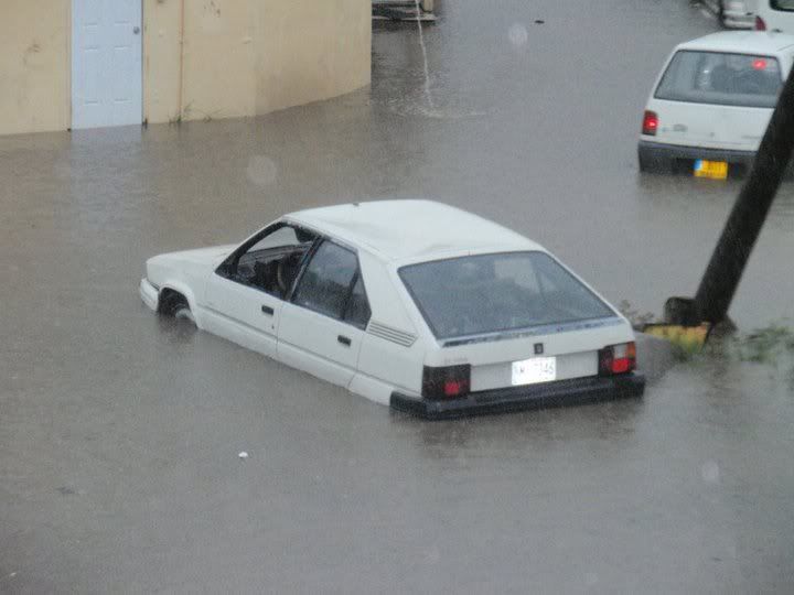
HI guys
I am still off island but am receiving reports from St Maarten of heavy flooding
from this morning.
I don't know how bad it was but some people posted pictures like this on Facebook
I am still off island but am receiving reports from St Maarten of heavy flooding
from this morning.
I don't know how bad it was but some people posted pictures like this on Facebook
0 likes
Too many hurricanes to remember
-
Gustywind
- Category 5
- Posts: 12334
- Joined: Mon Sep 03, 2007 7:29 am
- Location: Baie-Mahault, GUADELOUPE
Re: Caribbean - CA=Strong Wave affecting Leewards,VI Puerto Rico
msbee wrote:HI guys
I am still off island but am receiving reports from St Maarten of heavy flooding
from this morning.
I don't know how bad it was but some people posted pictures like this on Facebook
0 likes
-
Gustywind
- Category 5
- Posts: 12334
- Joined: Mon Sep 03, 2007 7:29 am
- Location: Baie-Mahault, GUADELOUPE
A report from St Marteen at Stormcarib.com
http://www.stormcarib.com/reports/curre ... rtin.shtml
St.Maarten Weather Update July 18th 2010
By Erin Jaworski <erin.jaworski at gmail.com>
Date: Sun, 18 Jul 2010 15:15:49 -0400
Good Afternoon! The island of St.Maarten has been experiencing steady rainfall with scattered thunderstorms all day ( Sunday July 17th 2010 ). This system has been over the island all day, however there is a very low chance of the system turning into a tropical cyclone. The NWS is predicting a 10 percent chance that the Atlantic tropical wave will turn into a tropical cyclone over the next 48 hours. The precipitation and thunderstorms will continue throughout the night with easterly winds picking up in speed. Try and stay dry St.Maarten!
Erin Boucher
Cupecoy, St. Maarten
0 likes

-
cycloneye
- Admin
- Posts: 149473
- Age: 69
- Joined: Thu Oct 10, 2002 10:54 am
- Location: San Juan, Puerto Rico
Re: Caribbean - CA=Strong Wave affecting Leewards,VI Puerto Rico
FLOOD ADVISORY
NATIONAL WEATHER SERVICE SAN JUAN PR
528 PM AST SUN JUL 18 2010
PRC007-021-025-031-061-063-105-127-135-139-190030-
/O.NEW.TJSJ.FA.Y.0274.100718T2128Z-100719T0030Z/
/00000.N.ER.000000T0000Z.000000T0000Z.000000T0000Z.OO/
BAYAMON PR-CAGUAS PR-AGUAS BUENAS PR-GURABO PR-NARANJITO PR-
TOA ALTA PR-TRUJILLO ALTO PR-GUAYNABO PR-CAROLINA PR-SAN JUAN PR-
528 PM AST SUN JUL 18 2010
THE NATIONAL WEATHER SERVICE IN SAN JUAN HAS ISSUED AN
* URBAN AND SMALL STREAM FLOOD ADVISORY FOR RAPID RIVER RISES IN
FOR THE FOLLOWING MUNICIPALITIES...
IN PUERTO RICO
BAYAMON...CAGUAS...AGUAS BUENAS...GURABO...NARANJITO...TOA
ALTA...TRUJILLO ALTO...GUAYNABO...CAROLINA AND SAN JUAN
* UNTIL 830 PM AST
* AT 525 PM AST...NATIONAL WEATHER SERVICE DOPPLER RADAR DETECTED
HEAVY RAINFALL ACROSS SAN JUAN AND VICINITY. THE HEAVIEST RAINFALL
HAD FALLEN ACROSS SECTIONS OF BAYAMON...GUAYNABO AND SAN JUAN.
ADDITIONAL RAINFALL AMOUNTS OF ONE INCH ARE POSSIBLE IN THE ADVISORY
AREA. THIS SHOWER ACTIVITY WILL HAVE THE CAPABILITY OF PRODUCING
RAPID RISES IN SMALL STREAMS AND CREEKS...AND PONDING OF WATER IN
URBAN AREAS... HIGHWAYS...STREETS AND UNDERPASSES AS WELL AS OTHER
POOR DRAINAGE AREAS AND LOW LYING SPOTS.
MOST FLOOD DEATHS OCCUR IN AUTOMOBILES. NEVER DRIVE YOUR VEHICLE INTO
AREAS WHERE THE WATER COVERS THE ROADWAY. FLOOD WATERS ARE USUALLY
DEEPER THAN THEY APPEAR. JUST ONE FOOT OF FLOWING WATER IS POWERFUL
ENOUGH TO SWEEP VEHICLES OFF THE ROAD. WHEN ENCOUNTERING FLOODED
ROADS MAKE THE SMART CHOICE...TURN AROUND...DONT DROWN.
0 likes
Visit the Caribbean-Central America Weather Thread where you can find at first post web cams,radars
and observations from Caribbean basin members Click Here
and observations from Caribbean basin members Click Here
-
cycloneye
- Admin
- Posts: 149473
- Age: 69
- Joined: Thu Oct 10, 2002 10:54 am
- Location: San Juan, Puerto Rico
Re: Caribbean - CA=Strong Wave affecting Leewards,VI Puerto Rico
Weather Station from Anguilla.
http://www.anguilla-weather.com/
http://stormcarib.com/reports/current/anguilla.shtml
http://www.anguilla-weather.com/
http://stormcarib.com/reports/current/anguilla.shtml
0 likes
Visit the Caribbean-Central America Weather Thread where you can find at first post web cams,radars
and observations from Caribbean basin members Click Here
and observations from Caribbean basin members Click Here
-
tropicana

- Category 5
- Posts: 8056
- Joined: Sat Sep 27, 2003 6:48 pm
- Location: Niagara Falls, Ontario, Canada
- Contact:
Re: Caribbean - CA=Strong Wave affecting Leewards,VI Puerto Rico
72mm of rain has fallen at Juliana Airport, St Maarten in just 6 hours ending at 2pm today.. this will verify that flooding there.
At Golden Rock, St Kitts, 50mm of rain has also fallen.
At Grantley Adams, Barbados, nearly 42mm of rain swamped the airport overnight in just 2 hours just before midnight.
Earlier in the day, Crown Point, Tobago saw upwards of 50mm of rain this weekend as well.
-justin-
At Golden Rock, St Kitts, 50mm of rain has also fallen.
At Grantley Adams, Barbados, nearly 42mm of rain swamped the airport overnight in just 2 hours just before midnight.
Earlier in the day, Crown Point, Tobago saw upwards of 50mm of rain this weekend as well.
-justin-
0 likes
Re: Caribbean - CA=Strong Wave affecting Leewards,VI Puerto Rico
thanks Justin
as I was off island I was wondering how much actual rain fell in st maarten
no wonder the place flooded out.
Barbara
as I was off island I was wondering how much actual rain fell in st maarten
no wonder the place flooded out.
Barbara
0 likes
Too many hurricanes to remember
-
knotimpaired
- Category 1
- Posts: 495
- Joined: Fri May 20, 2005 4:14 am
- Location: Vieques, PR
- Contact:
Re: Caribbean - CA=Strong Wave affecting Leewards,VI Puerto Rico
Gustywind wrote:knotimpaired wrote:For some reason it is not updating online. I have the Weatherhawk program on my computer and it says now we have had 1.26". It will catch up eventually.
K
Hi Karen glad to see you back here! Hope that right now you can post a pic

Hi Gusty. I am ALWAYS here watching all of everyone's great posts and observations.
I am on the Board for the Vieques Humane Society and it is currently taking up most of my time. But when the s@#t hits the fan, my attention will be with Storm2k, 24/7
0 likes
-
Gustywind
- Category 5
- Posts: 12334
- Joined: Mon Sep 03, 2007 7:29 am
- Location: Baie-Mahault, GUADELOUPE
Re: Caribbean - CA=Strong Wave affecting Leewards,VI Puerto Rico
knotimpaired wrote:Gustywind wrote:knotimpaired wrote:For some reason it is not updating online. I have the Weatherhawk program on my computer and it says now we have had 1.26". It will catch up eventually.
K
Hi Karen glad to see you back here! Hope that right now you can post a pic
Hi Gusty. I am ALWAYS here watching all of everyone's great posts and observations.
I am on the Board for the Vieques Humane Society and it is currently taking up most of my time. But when the s@#t hits the fan, my attention will be with Storm2k, 24/7
Oh how kind you are
0 likes
-
cycloneye
- Admin
- Posts: 149473
- Age: 69
- Joined: Thu Oct 10, 2002 10:54 am
- Location: San Juan, Puerto Rico
Re: Caribbean - CA=Strong Wave affecting Leewards,VI Puerto Rico
Until 6:51 PM EDT .50 has fallen in San Juan. That rainfall data continues to add to the 2010 record rainfall total now at 45.19 inches, that is 22.94 inches above normal.
Code: Select all
WEATHER ITEM   OBSERVED TIME   RECORD YEAR NORMAL DEPARTURE LAST
                VALUE   (LST)  VALUE       VALUE  FROM      YEAR
                                                  NORMAL

PRECIPITATION (IN)
  TODAY            0.50          2.17 1969   0.14   0.36     0.46
  MONTH TO DATE    4.75                      2.27   2.48     1.76
  SINCE JUN 1     13.98                      5.79   8.19    12.13
  SINCE JAN 1     45.19                     22.25  22.94    29.23
0 likes
Visit the Caribbean-Central America Weather Thread where you can find at first post web cams,radars
and observations from Caribbean basin members Click Here
and observations from Caribbean basin members Click Here

Re: Caribbean - CA=Strong Wave affecting Leewards,VI Puerto Rico
In El Salvador the rains have left at least 1500 people affected, you can see a few pictures of the floods here:
http://www.elsalvador.com/mwedh/nota/popGaleria.asp?idArt=4980934&idcat=6364
By the way, the newspaper says in one of the pictures that a tropical depression is affecting the country but we know that's not true.
And this is the map with the rainfall between 7:00 am yesterday and 7:00 am today, the maximum was 95.7 mm/3.77 inches.
0 likes
-
cycloneye
- Admin
- Posts: 149473
- Age: 69
- Joined: Thu Oct 10, 2002 10:54 am
- Location: San Juan, Puerto Rico
Re: Caribbean - CA=Strong Wave affecting Leewards,VI Puerto Rico
TROPICAL WEATHER OUTLOOK
NWS TPC/NATIONAL HURRICANE CENTER MIAMI FL
800 PM EDT SUN JUL 18 2010
FOR THE NORTH ATLANTIC...CARIBBEAN SEA AND THE GULF OF MEXICO...
A TROPICAL WAVE IN THE VICINITY OF THE LEEWARD ISLANDS CONTINUES TO
PRODUCE DISORGANIZED SHOWERS AND THUNDERSTORMS. ALTHOUGH SURFACE
PRESSURES HAVE FALLEN SLIGHTLY OVER THE AREA...ANY DEVELOPMENT OF
THIS DISTURBANCE IS LIKELY TO BE SLOW TO OCCUR AS IT MOVES WEST-
NORTHWESTWARD AT ABOUT 15 MPH. THERE IS A LOW CHANCE...10
PERCENT...OF THIS SYSTEM BECOMING A TROPICAL CYCLONE DURING THE
NEXT 48 HOURS. REGARDLESS OF DEVELOPMENT...GUSTY WINDS AND LOCALLY
HEAVY RAINFALL ASSOCIATED WITH THIS SYSTEM COULD AFFECT THE LEEWARD
ISLANDS...THE VIRGIN ISLANDS...PUERTO RICO...THE DOMINICAN
REPUBLIC...HAITI...AND THE TURKS AND CAICOS ISLANDS DURING THE NEXT
COUPLE OF DAYS.
ANOTHER TROPICAL WAVE IS PRODUCING SHOWERS AND THUNDERSTORMS OVER
PORTIONS OF THE CENTRAL CARIBBEAN SEA. THERE ARE NO SIGNS OF A
SURFACE CIRCULATION IN THIS AREA AND DEVELOPMENT...IF ANY...OF THIS
DISTURBANCE SHOULD BE SLOW TO OCCUR AS IT MOVES GENERALLY WESTWARD
AT 10 TO 15 MPH. THERE IS A LOW CHANCE...10 PERCENT...OF THIS
SYSTEM BECOMING A TROPICAL CYCLONE DURING THE NEXT 48 HOURS.
ELSEWHERE...TROPICAL CYCLONE FORMATION IS NOT EXPECTED DURING THE
NEXT 48 HOURS.
$$
FORECASTER PASCH
0 likes
Visit the Caribbean-Central America Weather Thread where you can find at first post web cams,radars
and observations from Caribbean basin members Click Here
and observations from Caribbean basin members Click Here
-
Gustywind
- Category 5
- Posts: 12334
- Joined: Mon Sep 03, 2007 7:29 am
- Location: Baie-Mahault, GUADELOUPE
000
AXNT20 KNHC 182353
TWDAT
TROPICAL WEATHER DISCUSSION
NWS TPC/NATIONAL HURRICANE CENTER MIAMI FL
805 PM EDT SUN JUL 18 2010
TROPICAL WEATHER DISCUSSION FOR NORTH AMERICA...CENTRAL
AMERICA...GULF OF MEXICO...CARIBBEAN SEA...NORTHERN SECTIONS OF
SOUTH AMERICA...AND ATLANTIC OCEAN TO THE AFRICAN COAST FROM THE
EQUATOR TO 32N. THE FOLLOWING INFORMATION IS BASED ON SATELLITE
IMAGERY...METEOROLOGICAL ANALYSIS...WEATHER OBSERVATIONS...AND
RADAR.
BASED ON 1800 UTC SURFACE ANALYSIS AND SATELLITE IMAGERY THROUGH
2345 UTC...
...TROPICAL WAVES...
TROPICAL WAVE IS JUST E OF THE LESSER ANTILLES ALONG 61W S OF
19N MOVING W NEAR 15 KT. BROAD CYCLONIC FLOW ENCOMPASSES THE
WAVE AXIS EVIDENT IN SATELLITE IMAGERY. A LARGE AREA OF DEEP
LAYER MOISTURE ALSO ACCOMPANIES THE WAVE SEEN IN TOTAL
PRECIPITABLE WATER IMAGERY. SCATTERED MODERATE TO STRONG
CONVECTION IS FROM 14N-22N BETWEEN 54W-67W. GUSTY WINDS AND
LOCALLY HEAVY RAINFALL ASSOCIATED WITH THIS SYSTEM COULD AFFECT
THE LEEWARD ISLANDS...THE VIRGIN ISLANDS...PUERTO RICO...THE
DOMINICAN REPUBLIC...HAITI...AND THE TURKS AND CAICOS ISLANDS
DURING THE NEXT COUPLE OF DAYS.
TROPICAL WAVE IS OVER THE CENTRAL CARIBBEAN ALONG 77W S OF 20N
MOVING W 15-20 KT. WAVE LIES EMBEDDED WITHIN A LARGE AREA OF
DEEP LAYER MOISTURE THAT IS ACROSS CENTRAL THE CARIBBEAN.
SCATTERED MODERATE/STRONG CONVECTION IS FROM 14N-22N BETWEEN
70W-80W AFFECTING AREAS S OF WESTERN HISPANIOLA...JAMAICA AND
EASTERN CUBA.
FOR ADDITIONAL INFORMATION PLEASE VISIT
HTTP://WWW.HURRICANES.GOV/MARINE
$$
GARCIA
0 likes
Return to “USA & Caribbean Weather”
Who is online
Users browsing this forum: Google Adsense [Bot] and 68 guests