Severe weather possible Friday afternoon-Saturday morning.
Area actually lucked out for the most part yesterday…except around Matagorda Bay where an intense small bow echo swept offshore in the late afternoon. An impressive 87mph wind gust was recorded at the Gulf buoy 019 south of Freeport, TX
Tropical air mass along the TX coast has advected northward today with 70 degree dewpoints covering much of the area. Sub-tropical jet remains located across MX into TX with weak disturbances rotating around the southern flank of the upper level storm system over the SW US. The overall setup over much of TX is favorable for severe weather, but mid level capping on mid level winds blowing off the higher terrain of NE MX has effectively capped off the unstable low level air mass preventing thunderstorm formation…this was clearly seen today with a complete lack of any vertical development of the clouds over the region.
Friday/Saturday:
A stronger disturbance will move into TX Friday in combination with an approaching frontal boundary and an air mass that becomes very unstable by early afternoon. Cooling and lift with the disturbance aloft will begin to weaken the capping inversion by late morning and convection allowing models show rapid development by early afternoon along and ahead of the W TX dryline/cold front. Initial storm mode will likely be supercells with extremely large hail and isolated tornadoes across C TX…this activity will then transition in lines or clusters by late afternoon/evening as it approaches SE TX. Severe mode will gradually transition into a damaging wind and hail threat into Friday night. TX TECH WRF model which has done well of late shows two rounds of storms…a round that develops late tonight and weakens as it approaches the area Friday morning followed by another round Friday evening.
Saturday afternoon/Sunday:
Should be a fairly quiet period as the region falls between upper air systems. Very warm and humid conditions will be in place…so it will begin to feel like summer with highs near 90 on Sunday.
Monday:
A very active weather day appears in store for Monday with several parameters coming together to produce both severe weather and potentially very heavy rainfall. A fairly potent upper air disturbance is expected to swing across SC and then SE TX during the day at the same time a strong cold front for late April sweeps across the region. Impressive sub-tropical jet streak will aid in lift and the air mass appears unstable and uncapped. All signs point to a very active day with rounds of severe thunderstorms possible and flooding rainfall. Still well out to fine tune the threats and locations of best threats…but wanted to get the “heads up” prior to the weekend.
Texas Spring-2015
Moderator: S2k Moderators
Forum rules

The posts in this forum are NOT official forecast and should not be used as such. They are just the opinion of the poster and may or may not be backed by sound meteorological data. They are NOT endorsed by any professional institution or STORM2K.
-
gboudx

- S2K Supporter

- Posts: 4090
- Joined: Thu Sep 04, 2003 1:39 pm
- Location: Rockwall, Tx but from Harvey, La
Update from Jeff:
0 likes
-
TheProfessor

- Professional-Met

- Posts: 3506
- Age: 29
- Joined: Tue Dec 03, 2013 10:56 am
- Location: Wichita, Kansas
-
TheProfessor
- Professional-Met
- Posts: 3506
- Age: 29
- Joined: Tue Dec 03, 2013 10:56 am
- Location: Wichita, Kansas

-
TheProfessor
- Professional-Met
- Posts: 3506
- Age: 29
- Joined: Tue Dec 03, 2013 10:56 am
- Location: Wichita, Kansas
Re: Texas Spring-2015
This post was made by Steve McCauley, he explains why nothing Wednesday. I read one of the comments, and I found out it was only 68 degrees during the mayfest hail storm.
Warning: What follows is pure Geek Speak. If you are a weather nerd, I hope you find it interesting. If you are not, then I only have this to say: Abandon hope all ye who enter here
wink emoticon
I feel that the highly advertised severe weather event that never happened last night deserves at least a modicum of an attempt at an explanation. Since those of us in the broadcast and social media arena (including Yours Truly) , the National Weather Service, and the Storm Prediction Center in Norman, Oklahoma were all pretty much in agreement that a significant severe weather event was in the cards for the DFW Metroplex last night, I thought I would try to explain why we all thought the way we did, and why the DFW area and much of north Texas were placed in an Enhanced Risk for severe storms, and why it all went belly up in spite of what appeared to be an almost sure thing
First, there was a general agreement that the best chance for severe weather in the Metroplex would be after sundown. Daytime action was a slight chance at best. But severe supercell thunderstorms (i.e., storms that possess a strong rotating updraft) were expected to fire off the dryline in west Texas in the afternoon and then move in our direction at night. And that did indeed happen with numerous reports of large hail, high winds, and isolated tornado touchdowns from the Panhandle and points to the SE, all the way down to the area just SW of Wichita Falls.
Those storms were expected to maintain their severity as they pushed into the Metroplex from the NW. But they did not. Why not? Was it the oft-maligned Godzilla Cap? No. Sinking air? No. Secret anti-storm ray guns? No.
To answer, let me talk about a concept known as HELICITY. Helicity is a mathematical calculation that attempts to gauge the amount of "spin" that is in the atmosphere due to winds changing speed and direction with height. Storms can use this "spin" to generate large hail, damaging winds, and to produce tornadoes.
Without going into the actual mathematical formula (it's a doozy!), let me just say this: A value of 150 for Helicity is loosely considered to be a threshold value to support supercell formation. If it is much lower than that, it is usually very difficult to get a storm to rotate. But the higher the helicity value goes above 150, the bigger the hail, the higher the damaging wind potential, and the higher the threat for tornadoes.
As you can see by the top image in this graphic, the PREDICTED value of helicity for the DFW area - and indeed stretching across much north Texas - was well above the threshold of 150. It was over 350, even exceeding 400 in places ! That is more than enough to support large hail, damaging winds, and isolated tornadoes.
So the tornadic supercell storms in the Panhandle (which were forming in an area with helicity values close to 500!) were expected to slide down this high helicity field and maintain their rotation and associated severe weather risk as they plowed their way into the Metroplex.
But remember, this was the PREDICTED helicity field. Now look at what ACTUALLY happened. The high helicity field that was supposed to stretch clear across north Texas suddenly cut off 90 miles west of Fort Worth. There was no longer a "bridge" of spinning air connecting the Panhandle to north Texas. This bridge was expected to serve as a conduit that would allow those supercells in the Panhandle to keep spinning all the way to DFW and beyond.
Note how quickly the helicity values went from greater than 300 in west Texas (even after the initial storms had left that area) down to around 150 about 90 miles west of Fort Worth. The PREDICTED bridge of 350-400 helicity values across all of north Texas was altogether absent.
It is no coincidence that the cutoff point was the same exact area that saw those violent supercell thunderstorms from the Panhandle quickly lose their spin and degrade and collapse into just plain ole, run-of-the-mill thunderstorms.
So, was there a way to know ahead of time that this "Helicity Bridge" would be cut in two and sever our link to the Panhandle storms? Not from any of the data I saw! Indeed, the Texas Tech Model - arguably the best computer model we have at predicting severe weather - maintained the integrity of this bridge, and as a result, it clobbered the DFW area last night with several supercell thunderstorms going right through the heart of the Metroplex! Hence my concern expressed the previous day.
But apparently that helicity bridge never got built, and the storms came tumbling down below severe levels not long after they left their source of rotating air in west Texas.
An update on tomorrow's potential will be forthcoming this evening.
0 likes
An alumnus of The Ohio State University.
Your local National Weather Service office is your best source for weather information.
Your local National Weather Service office is your best source for weather information.
-
aggiecutter
- Category 5

- Posts: 1755
- Joined: Thu Oct 14, 2004 9:22 pm
- Location: Texarkana
Re: Texas Spring-2015
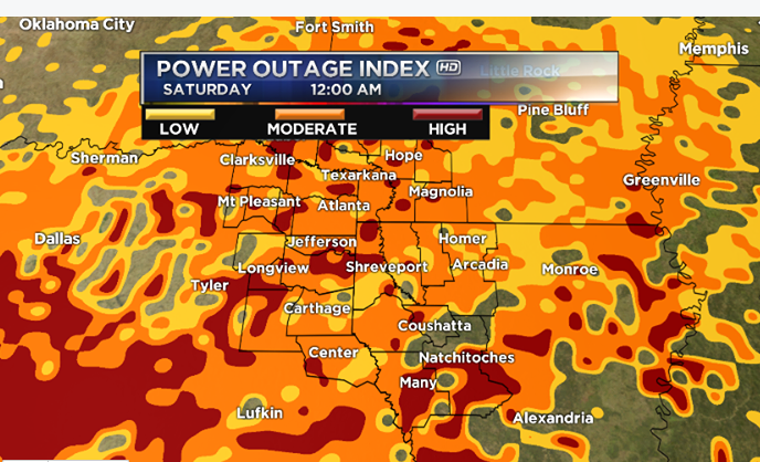
Interesting map from Todd Warren's Future-Cast weather model. According to his graphic, a lot Central Texas will be without power tomorrow night, or at least the probability exist:

0 likes
Re: Texas Spring-2015
aggiecutter wrote:Interesting map from Todd Warren's Future-Cast weather model. According to his graphic, a lot Central Texas will be without power tomorrow night, or at least the probability
Have you seen another version that shows more of central Texas like Austin/ San Antonio?
Edited to add: oh, NE TX meteorologist....
0 likes
-
aggiecutter
- Category 5
- Posts: 1755
- Joined: Thu Oct 14, 2004 9:22 pm
- Location: Texarkana
Re: Texas Spring-2015
Shoshana wrote:aggiecutter wrote:Interesting map from Todd Warren's Future-Cast weather model. According to his graphic, a lot Central Texas will be without power tomorrow night, or at least the probability
Have you seen another version that shows more of central Texas like Austin/ San Antonio?
Edited to add: oh, NE TX meteorologist....
Go to the URL below. Type in the city of your choice in Locations, which is located at the bottom of the page. If you want to save that particular location, click on save map view(just above where you type in location) after typing in location. On the toolbar on the bottom of the radar, click on past then >(play) to get a radar loop from the past 2 hours. Click on Future then >(play) and you will get the Future-Cast weather model radar projections for the next 24 hours. The Future weather model radar projections is what I find as being most useful. On a side note, if you push play for Future radar projections for the next 24 hours, the loop runs kinda fast. The best way to view Future radar projections is by using the >forward and <previous arrows. That will increment the radar projection in one hour increments one way or the other.
http://www.arklatexhomepage.com/weather#
0 likes
Re: Texas Spring-2015
aggiecutter wrote:Shoshana wrote:aggiecutter wrote:Interesting map from Todd Warren's Future-Cast weather model. According to his graphic, a lot Central Texas will be without power tomorrow night, or at least the probability
Have you seen another version that shows more of central Texas like Austin/ San Antonio?
Edited to add: oh, NE TX meteorologist....
Go to the URL below. Type in the city of your choice in Locations, which is located at the bottom of the page. If you want to save that particular location, click on save map view(just above where you type in location) after typing in location. On the toolbar on the bottom of the radar, click on past then >(play) to get a radar loop from the past 2 hours. Click on Future then >(play) and you will get the Future-Cast weather model radar projections for the next 24 hours. The Future weather model radar projections is what I find as being most useful. On a side note, if you push play for Future radar projections for the next 24 hours, the loop runs kinda fast. The best way to view Future radar projections is by using the >forward and <previous arrows. That will increment the radar projection in one hour increments one way or the other.
http://www.arklatexhomepage.com/weather#
Oh, thank you. I saw radar but not the power outage map. It's ok, we have underground utilities. But that's amazingly widespread on the map you posted. I didn't even know we're supposed to get rain tonight. No watches up yet
0 likes
-
TheProfessor
- Professional-Met
- Posts: 3506
- Age: 29
- Joined: Tue Dec 03, 2013 10:56 am
- Location: Wichita, Kansas
-
TheProfessor
- Professional-Met
- Posts: 3506
- Age: 29
- Joined: Tue Dec 03, 2013 10:56 am
- Location: Wichita, Kansas
-
TheProfessor
- Professional-Met
- Posts: 3506
- Age: 29
- Joined: Tue Dec 03, 2013 10:56 am
- Location: Wichita, Kansas
-
Brent
- S2K Supporter
- Posts: 38740
- Age: 37
- Joined: Sun May 16, 2004 10:30 pm
- Location: Tulsa Oklahoma
- Contact:
Re: Texas Spring-2015
With a lot of caveats about the morning convection(it's going to make or break this thing imo) they put this out:

TIMING IS A BIT MORE UNCERTAIN ACROSS PARTS OF NORTHERN TEXAS... BUT
IT MAY BE CLOSER TO...OR AFTER...25/00Z...WHEN LARGE-SCALE FORCING
AND INSTABILITY MAY SUPPORT AN UPSCALE GROWING MESOSCALE CONVECTIVE
SYSTEM. VERY LARGE HAIL MAY BE POSSIBLE WITH INITIAL
ACTIVITY...BEFORE THE RISK OF DAMAGING WIND GUSTS BECOMES MORE
PROMINENT DURING THE EVENING. IT IS POSSIBLE THAT THE EVOLVING
CONVECTIVE SYSTEM COULD BE PRECEDED BY DISCRETE SUPERCELL STORMS
WHICH COULD POSE A MORE APPRECIABLE RISK FOR
TORNADOES...PARTICULARLY AS ACTIVITY SPREADS TOWARD THE ARKLATEX
REGION...COINCIDENT WITH STRENGTHENING OF INITIALLY MODEST SOUTHERLY
850 MB FLOW FIELDS.
Last edited by Brent on Fri Apr 24, 2015 1:23 am, edited 1 time in total.
0 likes
#neversummer

-
TheProfessor
- Professional-Met
- Posts: 3506
- Age: 29
- Joined: Tue Dec 03, 2013 10:56 am
- Location: Wichita, Kansas
-
SouthernMet

- Category 3

- Posts: 857
- Joined: Sun Aug 29, 2010 8:23 pm
- Location: fort worth, tx
Re: Texas Spring-2015
This evening is going to be fun. Everyone stay safe!
0 likes
Nothing that SouthernMet posts, is an official forecast,nor does it reflect views of STORM2K.. SouthernMet is just adding to the great discussions on STORM2K.. Refer to NWS for official forecasts.
-
TheProfessor
- Professional-Met
- Posts: 3506
- Age: 29
- Joined: Tue Dec 03, 2013 10:56 am
- Location: Wichita, Kansas
Return to “USA & Caribbean Weather”
Who is online
Users browsing this forum: Cpv17 and 32 guests