Page 33 of 69
Re: Texas Spring 2018
Posted: Thu Apr 12, 2018 2:51 pm
by Ralph's Weather
Looks like another cool weekend. Almost a duplicate of last weekend. 50s for highs with 40s for highs possible if the clouds hold on Saturday. Clearing out likely by Saturday night could lead to a widespread late frost or even freeze for much of the state. NAM showing 30s down to the coast Sunday morning.
Re: Texas Spring 2018
Posted: Thu Apr 12, 2018 3:35 pm
by bubba hotep
ngturner1 wrote:Bubba, where are you finding that Texas SPC product?
Here is the link, I believe it used to be an ftp but is now a public http.
http://www.spc.noaa.gov/public/state/images/
Re: Texas Spring 2018
Posted: Thu Apr 12, 2018 3:39 pm
by bubba hotep
Ralph's Weather wrote:Looks like another cool weekend. Almost a duplicate of last weekend. 50s for highs with 40s for highs possible if the clouds hold on Saturday. Clearing out likely by Saturday night could lead to a widespread late frost or even freeze for much of the state. NAM showing 30s down to the coast Sunday morning.
FWD has point forecast IMBY of 34. If winds relax then very well may get a freeze. Luckily, most of my garden is still below the edges of the raised bed making it easy to cover.
Re: Texas Spring 2018
Posted: Thu Apr 12, 2018 3:58 pm
by ngturner1
Re: Texas Spring 2018
Posted: Thu Apr 12, 2018 4:01 pm
by weatherdude1108
Although I question these last freeze dates (think they should be later), according to this, most of us are well past the average last freeze dates for our respective cities.
DFW (March 13th)
Austin (February 26th)
Houston (February 18th)
Wichita Falls (March 27th)
April 25th in Dalhart is the latest last freeze date I saw on here.
Re: Texas Spring 2018
Posted: Thu Apr 12, 2018 4:04 pm
by Brent
weatherdude1108 wrote:Although I question these last freeze dates (think they should be later), according to this, most of us are well past the average last freeze dates for our respective cities.
DFW (March 13th)
Austin (February 26th)
Houston (February 18th)
Wichita Falls (March 27th)
April 25th in Dalhart is the latest last freeze date I saw on here.
latest freeze ever in Dallas is tomorrow
100 in Vernon right now

Re: Texas Spring 2018
Posted: Thu Apr 12, 2018 4:17 pm
by weatherdude1108
Brent wrote:weatherdude1108 wrote:Although I question these last freeze dates (think they should be later), according to this, most of us are well past the average last freeze dates for our respective cities.
DFW (March 13th)
Austin (February 26th)
Houston (February 18th)
Wichita Falls (March 27th)
April 25th in Dalhart is the latest last freeze date I saw on here.
latest freeze ever in Dallas is tomorrow
100 in Vernon right now

Crazy! Meant to add for Dalhart the latest
average last freeze.
Re: Texas Spring 2018
Posted: Thu Apr 12, 2018 7:44 pm
by downsouthman1
With these 70's across the I-35 corridor, it's hard to believe Childress is 95 right now.
Re: Texas Spring 2018
Posted: Thu Apr 12, 2018 8:02 pm
by Ntxw
downsouthman1 wrote:With these 70's across the I-35 corridor, it's hard to believe Childress is 95 right now.
Considering where the drought is, it would make sense


Re: Texas Spring 2018
Posted: Fri Apr 13, 2018 12:09 am
by downsouthman1
Ntxw wrote:downsouthman1 wrote:With these 70's across the I-35 corridor, it's hard to believe Childress is 95 right now.
Considering where the drought is, it would make sense


Winter destroyed the panhandle.
Re: Texas Spring 2018
Posted: Fri Apr 13, 2018 7:47 am
by bubba hotep
HRRR is interesting showing 2 rounds of storms for areas east of I35. If that were to verify MBY could be pushing 6"+ for April while the airport has been mostly dry.
Multiple rounds of storms raises the chance of a localized tornado threat as boundaries are laid down but it also raises questions about atmospheric recovery.
Re: Texas Spring 2018
Posted: Fri Apr 13, 2018 7:48 am
by bubba hotep
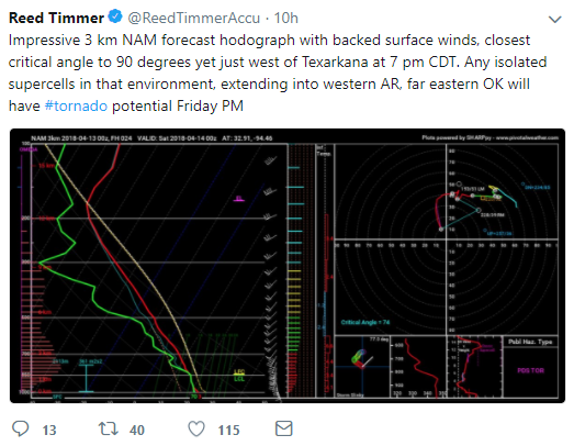
MOD added for the ArkLaTex

Re: Texas Spring 2018
Posted: Fri Apr 13, 2018 8:21 am
by Tireman4
000
FXUS64 KHGX 131145
AFDHGX
Area Forecast Discussion
National Weather Service Houston/Galveston TX
645 AM CDT Fri Apr 13 2018
.AVIATION...
MVFR ceilings in place across most TAF sites this morning, and
expecting these conditions to hold, potentially dropping to IFR
criteria at times, until the passing of the next cold front.
Gusty conditions also expected today, with a tight pressure
gradient in place ahead of the front. Light showers will be
possible across much of the region this morning. A secondary round
of showers and thunderstorms will develop this afternoon out
ahead of the front, with short term guidance hinting at the best
coverage more towards our northeastern terminals UTS/CXO. Expect a
break in precipitation early this evening before the arrival of
the actual cold front which based off most recent model guidance,
should reach CLL around 05Z and push off the coast by 12Z
Saturday. Showers and thunderstorms will be possible along this
boundary as it moves from north to south across SE TX. Winds will
back behind this frontal boundary, and a northwesterly wind should
prevail by sunrise Saturday.
Hathaway
Re: Texas Spring 2018
Posted: Fri Apr 13, 2018 8:36 am
by aggiecutter
Re: Texas Spring 2018
Posted: Fri Apr 13, 2018 8:37 am
by rwfromkansas
Well, frustratingly dry April here in Fort Worth. A few sprinkles this morning. Thank goodness for the crazy rains previously. Things are too progressive.
Re: Texas Spring 2018
Posted: Fri Apr 13, 2018 9:46 am
by aggiecutter
Look who is in Texarkana today:

Re: Texas Spring 2018
Posted: Fri Apr 13, 2018 10:07 am
by bubba hotep
Latest HRRR is firing the dryline just west of DFW. This is going to be a tricky setup, possibly similar to last week. Big hail could be major issue, portions of DFW are already included in the SPC hail hatch. If the dryline signal gets more obvious through the day then we might see a westard expansion by SPC or inclusion of DFW in any future watch box.
ETA: Newest HRRR is even slower with the dryline
Re: Texas Spring 2018
Posted: Fri Apr 13, 2018 10:24 am
by WacoWx
Getting excited to do some radar watching this afternoon!
Re: Texas Spring 2018
Posted: Fri Apr 13, 2018 10:34 am
by bubba hotep
We've had several booms of thunder this morning here in downtown. That could be a sign that moisture return was deeper than anticipated allowing these elevated cells to tap into some of the deeper instability. That deep moisture could make it easier for dryline storms to get going later.
Re: Texas Spring 2018
Posted: Fri Apr 13, 2018 10:37 am
by Texas Snowman

Maybe a boundary or two laid down this morning?


