Texas Spring 2026

U.S. & Caribbean Weather Discussions and Severe Weather Events

Moderator: S2k Moderators

Forum rules

The posts in this forum are NOT official forecast and should not be used as such. They are just the opinion of the poster and may or may not be backed by sound meteorological data. They are NOT endorsed by any professional institution or STORM2K.

Help Support Storm2K
Message
Author
User avatar
wxman22
Category 5
Category 5
Posts: 1999
Joined: Mon Jan 30, 2006 12:39 am
Location: Wichita Falls, TX
Contact:

Re: Texas Spring 2026

#641 Postby wxman22 » Fri Apr 10, 2026 4:10 pm

Image
Image

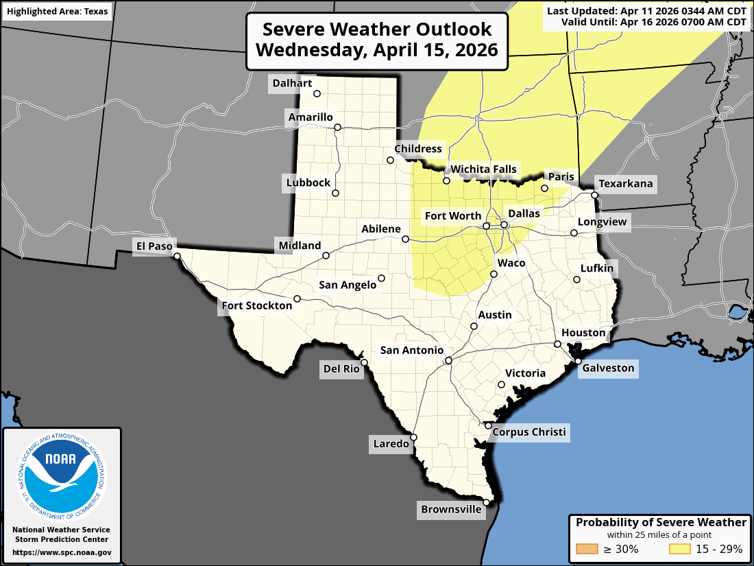
Day 3 Convective Outlook
NWS Storm Prediction Center Norman OK
0231 PM CDT Fri Apr 10 2026

Valid 121200Z - 131200Z

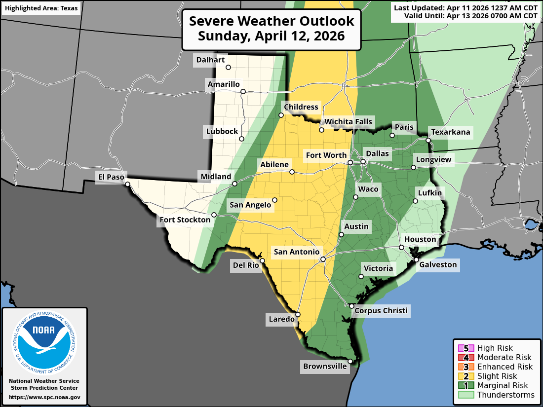
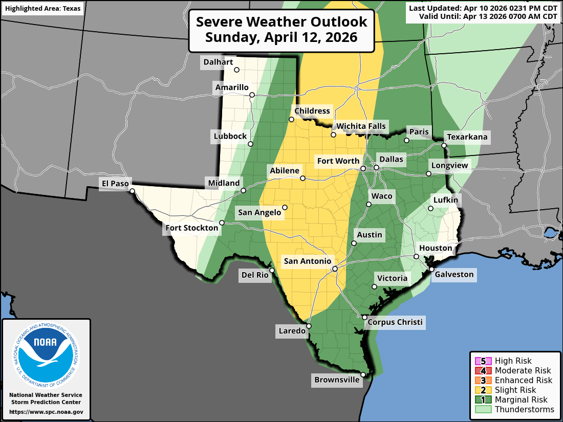
...THERE IS A SLIGHT RISK OF SEVERE THUNDERSTORMS ACROSS SOUTHERN
KANSAS...WESTERN AND CENTRAL OKLAHOMA...AND NORTHWEST TEXAS INTO
CENTRAL TEXAS....

...SUMMARY...
Isolated severe thunderstorms are possible from the southern and
central Plains into the Upper Midwest on Sunday.

...Synopsis...
On Sunday, a ridge will become established across the eastern CONUS
with a trough advancing slowly inland across the West. A weak
mid-level shortwave trough will move from the central Plains to the
Great Lakes during the period. Persistent mid-level flow across the
Rockies will continue lee troughing and northward moisture transport
across the Plains.

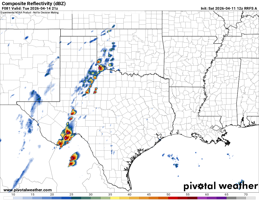
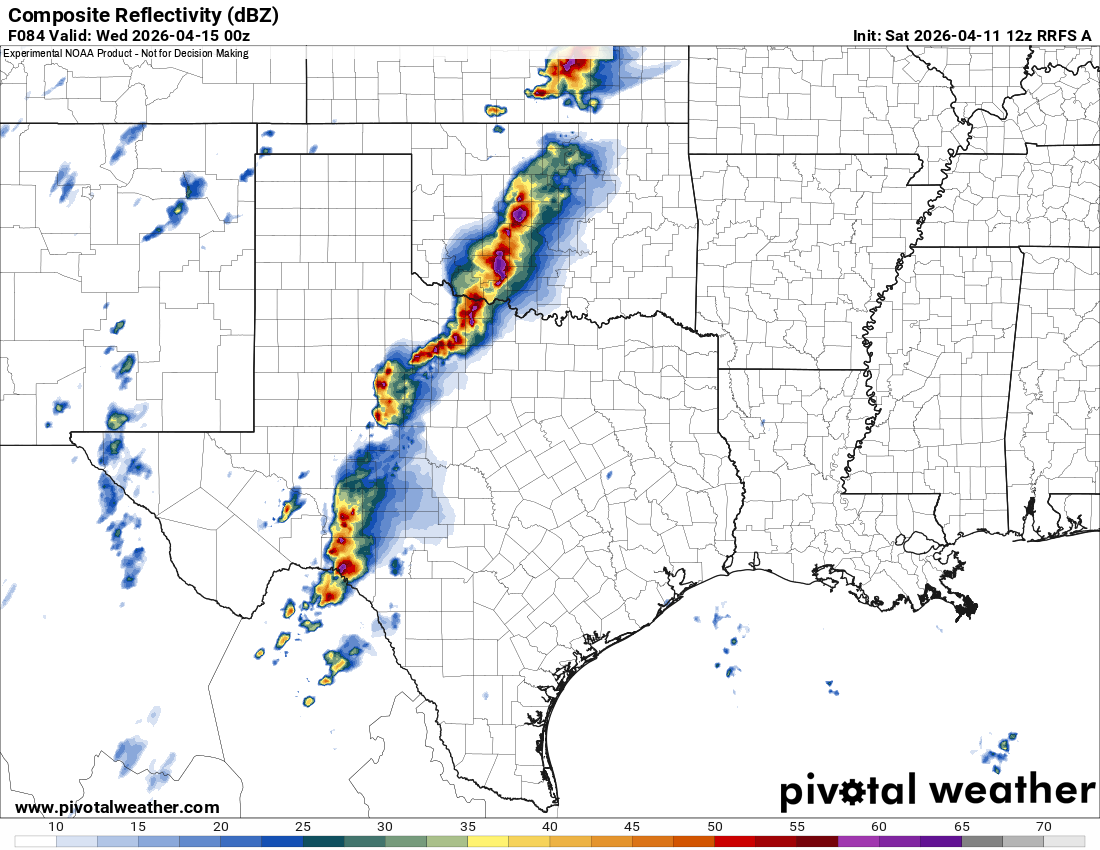
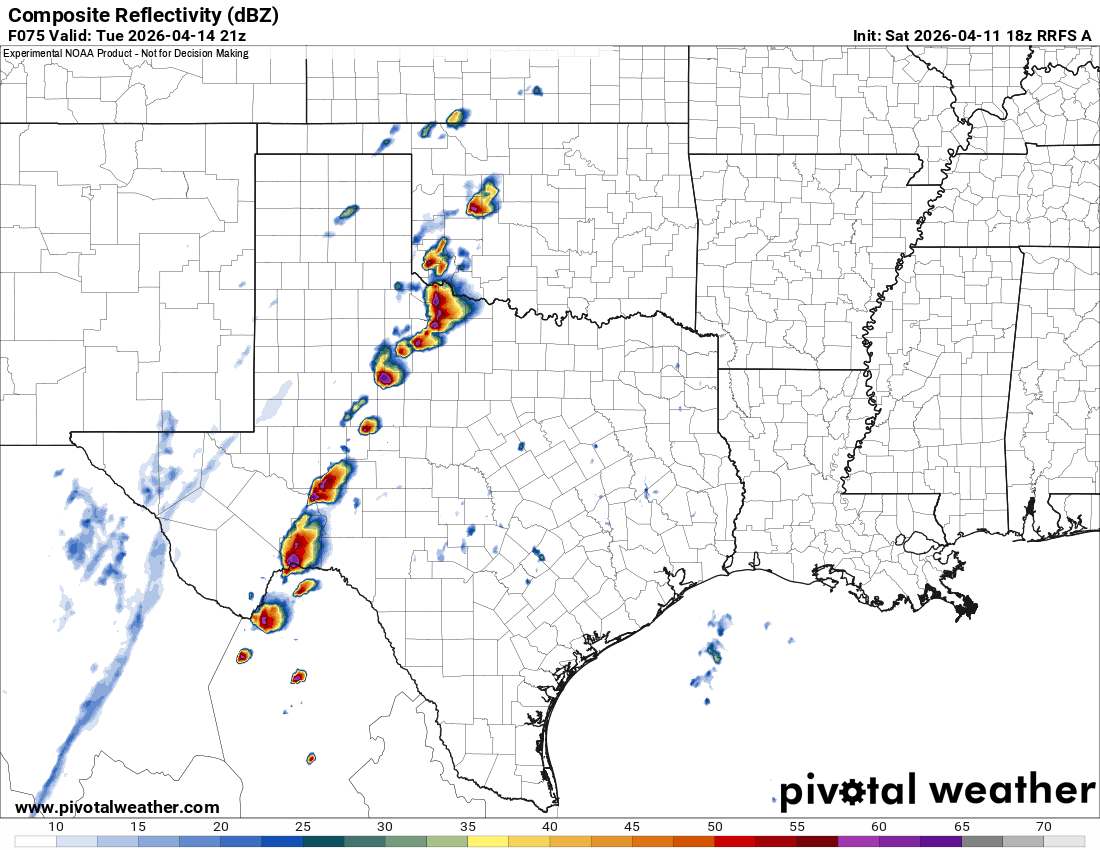
...Central/Southern Plains...
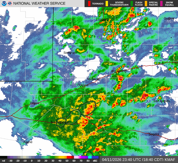
A large area of precipitation is expected to be ongoing Sunday
morning from central Oklahoma to central Texas. This is expected to
move slowly northeast through the day. Subsidence in the wake of the
morning shortwave trough associated with this activity should allow
for recovery ahead of the dryline from West Texas to central Kansas.
In addition, southwesterly to west-southwesterly flow aloft and a
well-established EML should assist in erosion of cloud cover across
this region by late morning. Therefore, by late Sunday afternoon,
moderate to strong instability is forecast to develop ahead of the
dryline.

Forcing across the warm sector remains weak and casts considerable
conditionality to the forecast. Guidance shows mostly neutral
heights across the dryline during the day. In addition, the dryline
remains relatively diffuse which would not support the strong
convergent circulations necessary for convective initiation.
However, it is worth noting that much of the guidance has a dryline
orientation oriented somewhat northeast to southwest. Therefore, any
convection which develops within this zone may have a long enough
residence time to mature before moving off of the dryline. Given the
expectation for minimal inhibition during the afternoon, this may
favor storm development along particular mesoscale corridors along
the dryline Sunday afternoon/early evening in an otherwise weakly
forced environment. Given moderate to potentially strong instability
and moderate shear, large hail (including the potential for 2+ inch
hail) will likely be the primary hazard with any supercells that
develop.

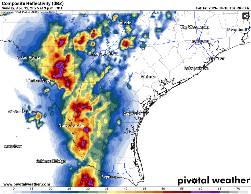
...Central/South Texas...
12Z guidance is fairly consistent with the depiction of a mid-level
shortwave trough moving across northern Mexico during the day
Sunday. Given the strong instability across northern Mexico and
south Texas, it would seem likely for storms to develop along the
higher terrain of northern Mexico during the afternoon/evening ahead
of this trough. Strong instability downstream could maintain these
storms through the evening with some potential for upscale growth
(such as shown by the RRFS). However, significant inhibition on
forecast soundings and minimal QPF signal from the global guidance,
combined with minimal convection over the higher terrain in Mexico
from the other CAM guidance out through 00Z casts some doubt on this
scenario.

An additional scenario is possible across central Texas. At the
southern end of the morning convection, continued storm development
is possible within a supercell environment. This scenario is less
certain given rising heights aloft and will likely be dictated by
the character of the cold pool from Saturday night/Sunday morning
storms. However, this is a scenario depicted by some guidance (most
notably the ECMWF) which could have a locally higher severe weather
threat across this region on Sunday afternoon.

0 likes   

Brent
S2K Supporter
S2K Supporter
Posts: 38769
Age: 37
Joined: Sun May 16, 2004 10:30 pm
Location: Tulsa Oklahoma
Contact:

Re: Texas Spring 2026

#642 Postby Brent » Fri Apr 10, 2026 8:29 pm

Today has definitely proven theres a lot of moisture already

I've noticed the severe hype has taken a huge hit up here also or maybe I just unfollowed everyone who was doing it :lol: :spam: someone was laughing about the 2011 comparisons just now
0 likes   
#neversummer

User avatar
wxman22
Category 5
Category 5
Posts: 1999
Joined: Mon Jan 30, 2006 12:39 am
Location: Wichita Falls, TX
Contact:

Re: Texas Spring 2026

#643 Postby wxman22 » Sat Apr 11, 2026 9:16 am

Image
Image
Image
Image
Image

..Day 4/Tue -- Southern Plains to Great Lakes...

A shortwave upper trough embedded within the larger-scale western
U.S. trough will eject across portions of the Plains to the Upper
Midwest on Day 4/Tue. As this occurs, a surface low will deep over
the central Plains and lift northeast across the Upper Midwest/Great
Lakes. Some uncertainty remains regarding the exact evolution of
this system, mainly due to differences in medium range guidance with
respect to surface low placement and timing of the upper shortwave
trough. Nevertheless, a moist and unstable airmass is expected ahead
of the low and to the east of a Plains dryline and south of a Great
Lakes warm front. Thunderstorm development should be more widespread
along these boundaries compared to prior days given stronger
large-scale ascent will overspread the central U.S., and height
falls will result in a more robust low-level jet response. As a
result, an all-hazards severe event is expected from the southern
Plains into portions of the Upper Midwest/Great Lakes vicinity on
Tuesday/Tuesday night.
0 likes   

TomballEd
Category 5
Category 5
Posts: 1318
Age: 62
Joined: Wed Aug 16, 2023 4:52 pm
Location: Spring/Klein area, not Tomball

Re: Texas Spring 2026

#644 Postby TomballEd » Sat Apr 11, 2026 9:28 am

Had some nice on again-off again rain yesterday. Even heard thunder (once).
0 likes   

User avatar
wxman22
Category 5
Category 5
Posts: 1999
Joined: Mon Jan 30, 2006 12:39 am
Location: Wichita Falls, TX
Contact:

Re: Texas Spring 2026

#645 Postby wxman22 » Sat Apr 11, 2026 10:57 am

Winds may get a little strong here overnight, as the CAM's have been consistently showing a Meso Low forming in NW Texas with the complex late tonight. With winds gusting over 50 mph.

The RRFS is also in range of Tuesday now. (Tuesday may be the peak day of this severe weather sequence.) It has the cap breaking with supercells firing along the dryline.

Image
Image
0 likes   

TomballEd
Category 5
Category 5
Posts: 1318
Age: 62
Joined: Wed Aug 16, 2023 4:52 pm
Location: Spring/Klein area, not Tomball

Re: Texas Spring 2026

#646 Postby TomballEd » Sat Apr 11, 2026 12:50 pm

wxman22 wrote:Winds may get a little strong here overnight, as the CAM's have been consistently showing a Meso Low forming in NW Texas with the complex late tonight. With winds gusting over 50 mph.

The RRFS is also in range of Tuesday now. (Tuesday may be the peak day of this severe weather sequence.) It has the cap breaking with supercells firing along the dryline.

https://i.postimg.cc/63tByFHr/rrfs_a_refcmp_us_sc_2026041112_81.png
https://i.postimg.cc/HxdTVFSn/rrfs_a_refcmp_us_sc_2026041112_84.png


I'm so impressed by high res CAMs that can actually show hook echoes. I also wonder how many tornadoes form over Chihuahua and Coahuila that don't get reported because of sparsely populated deserts.
0 likes   

rwfromkansas
Category 5
Category 5
Posts: 3047
Joined: Sat Aug 27, 2005 12:47 am
Location: North Fort Worth

Re: Texas Spring 2026

#647 Postby rwfromkansas » Sat Apr 11, 2026 1:27 pm

Staying further west longer. Even on Tuesday half of DFW isn’t included.
0 likes   

TomballEd
Category 5
Category 5
Posts: 1318
Age: 62
Joined: Wed Aug 16, 2023 4:52 pm
Location: Spring/Klein area, not Tomball

Re: Texas Spring 2026

#648 Postby TomballEd » Sat Apr 11, 2026 1:37 pm

TomballEd wrote:Had some nice on again-off again rain yesterday. Even heard thunder (once).


No thunder today, not yet anyway, but lawn mowing interrupted by fat and cold rain drops.
0 likes   

User avatar
wxman22
Category 5
Category 5
Posts: 1999
Joined: Mon Jan 30, 2006 12:39 am
Location: Wichita Falls, TX
Contact:

Re: Texas Spring 2026

#649 Postby wxman22 » Sat Apr 11, 2026 2:21 pm

The pop up showers all over the state shows that the atmosphere is moist.
0 likes   

User avatar
txtwister78
Category 5
Category 5
Posts: 2236
Joined: Wed Jan 30, 2019 12:56 pm
Location: San Antonio

Re: Texas Spring 2026

#650 Postby txtwister78 » Sat Apr 11, 2026 3:01 pm

wxman22 wrote:The pop up showers all over the state shows that the atmosphere is moist.


Moisture definitely not the issue with dewpoihts surging. Cloud cover across the state however will ultimately decide how active things become tomorrow for areas a little further east than today.

Ingredients will be in place just a question how much atmosphere can destabilize due to max or limited heating. CAM's will be all over the place so it's really just going to come down to real-time watching.
1 likes   

User avatar
txtwister78
Category 5
Category 5
Posts: 2236
Joined: Wed Jan 30, 2019 12:56 pm
Location: San Antonio

Re: Texas Spring 2026

#651 Postby txtwister78 » Sat Apr 11, 2026 3:04 pm

wxman22 wrote:The pop up showers all over the state shows that the atmosphere is moist.


Moisture definitely not the issue with dewpoints surging. Cloud cover across the state however will ultimately decide how active things become tomorrow for areas a little further east than today.

Ingredients will be in place just a question how much atmosphere can destabilize due to max or limited heating. CAM's will be all over the place so it's really just going to come down to real-time watching.
0 likes   

User avatar
wxman22
Category 5
Category 5
Posts: 1999
Joined: Mon Jan 30, 2006 12:39 am
Location: Wichita Falls, TX
Contact:

Re: Texas Spring 2026

#652 Postby wxman22 » Sat Apr 11, 2026 4:28 pm

Watching Tuesday closely.

Image
0 likes   

User avatar
wxman22
Category 5
Category 5
Posts: 1999
Joined: Mon Jan 30, 2006 12:39 am
Location: Wichita Falls, TX
Contact:

Re: Texas Spring 2026

#653 Postby wxman22 » Sat Apr 11, 2026 7:07 pm

Much needed rain occurring in west Texas right now. Love to see it!

Image
0 likes   

Fifty Rock
Tropical Storm
Tropical Storm
Posts: 158
Joined: Mon Sep 11, 2023 10:08 am
Location: Albany, Texas

Re: Texas Spring 2026

#654 Postby Fifty Rock » Sat Apr 11, 2026 10:06 pm

wxman22 wrote:Much needed rain occurring in west Texas right now. Love to see it!

https://i.postimg.cc/hjSbFpSG/KMAF-loop.gif


Already 4 inches here in the past couple hours.
1 likes   

User avatar
txtwister78
Category 5
Category 5
Posts: 2236
Joined: Wed Jan 30, 2019 12:56 pm
Location: San Antonio

Re: Texas Spring 2026

#655 Postby txtwister78 » Sat Apr 11, 2026 10:44 pm

Storms out west near Del Rio putting down some very heavy rain, hail/wind and even a tornado warning.
0 likes   

User avatar
CaptinCrunch
S2K Supporter
S2K Supporter
Posts: 8782
Age: 58
Joined: Mon Nov 03, 2003 4:33 pm
Location: Kennedale, TX (Tarrant Co.)

Re: Texas Spring 2026

#656 Postby CaptinCrunch » Sun Apr 12, 2026 8:13 am

Very little to no rain across DFW, zero thunder or lightning. Even over night it was spotty shower or two. Definitely not the forecast that was advertised on Friday, very disappointing indeed.
0 likes   

Brent
S2K Supporter
S2K Supporter
Posts: 38769
Age: 37
Joined: Sun May 16, 2004 10:30 pm
Location: Tulsa Oklahoma
Contact:

Re: Texas Spring 2026

#657 Postby Brent » Sun Apr 12, 2026 8:21 am

The whole storm seems to have trended down based off what I've seen online. The energy has trended less impressive like everything else the last few months

Especially the hype about Tuesday and Wednesday. Right now it looks like maybe a narrow line Tuesday night into Wednesday morning here and that's about it after all the hype and doom and comparisons to 2011. I'm glad we overperformed a little on Friday at least
1 likes   
#neversummer

Fifty Rock
Tropical Storm
Tropical Storm
Posts: 158
Joined: Mon Sep 11, 2023 10:08 am
Location: Albany, Texas

Re: Texas Spring 2026

#658 Postby Fifty Rock » Sun Apr 12, 2026 8:38 am

Well the night was very busy out here. We finished the night with 6.11 inches of rain, with 3inches of that in just 40 minutes.
2 likes   

User avatar
wxman22
Category 5
Category 5
Posts: 1999
Joined: Mon Jan 30, 2006 12:39 am
Location: Wichita Falls, TX
Contact:

Re: Texas Spring 2026

#659 Postby wxman22 » Sun Apr 12, 2026 9:38 am

From OUN (Norman) regarding Tuesday.

As the upper trough approaches the Plains Tuesday, southwesterly
flow will increase aloft with strengthening lee cyclogenesis across
northwest Kansas on Tuesday. The dryline will once again be setup
across a very similar area as Monday with quite a bit more
convergence present. Bulk shear will be nearly 50-60 knots with long
hodographs present and indicative of an environment supportive for
supercells. Height falls with the approaching trough axis and
dynamic cooling aloft will help MLCAPE values remain above 2500+
J/kg. Thus, storms that develop Tuesday afternoon and evening will
have the potential to support very large hail, damaging winds and
tornadoes. Storm chances are greater for Tuesday and less
conditional given the flow aloft becoming more supportive for storm
development and maintenance.
0 likes   

rwfromkansas
Category 5
Category 5
Posts: 3047
Joined: Sat Aug 27, 2005 12:47 am
Location: North Fort Worth

Re: Texas Spring 2026

#660 Postby rwfromkansas » Sun Apr 12, 2026 9:46 am

I guess the site is working for a few hours.

I did get .80, so I will take it, but seems like things will really be focused on West Texas most days now.
0 likes   


Return to “USA & Caribbean Weather”

Who is online

Users browsing this forum: WeatherNewbie and 171 guests