Moderator: S2k Moderators


rwfromkansas wrote:
This is hilarious. The entire event will end with DFW getting no severe weather at all. None.
Ntxw wrote:The good news everyone is basically above normal rainfall to date for the month. Some sites out west has achieved their monthly total and more.
The oddity, despite rumblings from our southeast TX friends, Houston has the highest total to date of all the major metros. Crazy how in one swoop, averages for regions can be met and catches up. Climo usually wins, everything is relative an inch for Houston is drought but an inch for Midland is drought buster.
The bad news, despite the rains everyone is 3-7F above normal and about half the month is almost done.


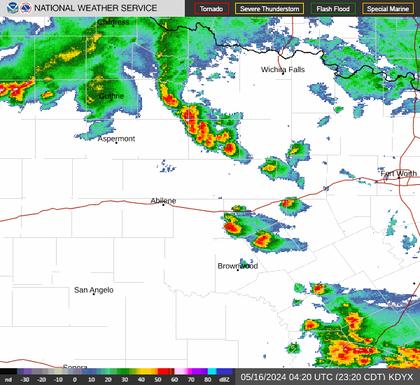
...Southern Plains including Oklahoma/Texas...
Confidence/potential for isolated to widely scattered locally
intense storms later this afternoon has incrementally increased,
although specifics regarding the extent of convective initiation are
still uncertain.
A moist and potentially unstable air mass will persist regionally to
the east of a dryline located around peak heating from east-central
Kansas south-southwestward into west-central Oklahoma and western
north Texas to the Texas Big Bend vicinity. Immediately east of the
dryline, warm-sector dewpoints are expected to generally be in the
middle 60s F, supporting MLCAPE values to 2500-3000 J/kg. A subtle
disturbance over northern Mexico and the southern Rockies could
approach the dryline/warm sector later today.
Regardless, ample post-dryline mixing and near-dryline
confluence/weak convergence should be sufficient for isolated deep
convective initiation after 21z/4pm CDT. Forecast mass fields and
some short-term guidance would imply that this is most probable
across central/southwest Oklahoma into the north Texas Big Country,
and perhaps somewhat separately across the Texas Big Bend and Rio
Grande vicinity.
If/where storms develop and mature, deep-layer shear on the order of
40+ kt will support supercells, potentially capable of all hazards
including very large hail.
HockeyTx82 wrote:Unless things change the latest HRRR run shows nothing, so I guess it's highly conditional?

wxman22 wrote:HockeyTx82 wrote:Unless things change the latest HRRR run shows nothing, so I guess it's highly conditional?
Yes, it’s a conditional threat. Depending if the cap breaks.

rwfromkansas wrote:
This is hilarious. The entire event will end with DFW getting no severe weather at all. None.

txtwister78 wrote:rwfromkansas wrote:
This is hilarious. The entire event will end with DFW getting no severe weather at all. None.
That's a good thing no??? I get the rain aspect.
So far down here we've been pretty fortunate to get the latter without the severe.
JDawg512 wrote:I am very happy that we got rain, however not as much as I would've hoped and this "active" period is not really so active after forecast from EWX were originally stating several days of rain on Friday for the middle of this week now looks like we won't see much of anything along the I35 corridor till Saturday. I'll take what we got and Austin finally looks green the way it's meant to this time of year but ultimately these wet periods are simply not lasting as long. Let's hope that blocking takes place to keep the southern storm track.
ElectricStorm wrote:Storms trying to fire off the dryline in NW TX, we'll see if they can sustain themselves. If so, sig severe is possible with a potent environment but still a decent chance we don't see much.
WeatherNewbie wrote:txtwister78 wrote:rwfromkansas wrote:
This is hilarious. The entire event will end with DFW getting no severe weather at all. None.
That's a good thing no??? I get the rain aspect.
So far down here we've been pretty fortunate to get the latter without the severe.
No kidding... hard pass on tornadoes and hail in the heart of severe weather season.
Return to “USA & Caribbean Weather”
Users browsing this forum: cstrunk and 186 guests