Florida Weather
Moderator: S2k Moderators
Forum rules

The posts in this forum are NOT official forecast and should not be used as such. They are just the opinion of the poster and may or may not be backed by sound meteorological data. They are NOT endorsed by any professional institution or STORM2K.

It came down in buckets, with a few wind gusts, and a weekend total rainfall of just over 2.4" here. That is more than the average for the month and it basically fell in 28 hours. That is April for you. I see no rainfall for the next 7-10 days forecast except slight tstorm chances toward the weekend, perhaps. I am sure it will be awhile, but basking in this glorious rain! 
0 likes

Re: Florida Weather
Did I see right? It is only supposed to reach a high of 71* Monday and Tuesday. Windy both days and a fire weather watch too. Dang.
Final rain total ------ drumroll please ----- 2.8"
Final rain total ------ drumroll please ----- 2.8"
0 likes
-
northjaxpro

- S2K Supporter

- Posts: 8900
- Joined: Mon Sep 27, 2010 11:21 am
- Location: Jacksonville, FL
It is currently 47.6 degrees at my home location at this hour. Quite a nice chill in the air and with the winds blowing around 10-15 mph currently, there is a wind chill for sure. Only expecting a high of near 70 degrees this afternoon as the cold air advection continues thanks to the deep upper level trough is anchored over the Eastern CONUS. The pressure gradient remains very strong today with the northwest winds funneling in between the building High in the Central Plains and the potent 985 mb Low currently over New Jersey. Very windy all through today across the peninsula.
Tonight will be the coldest night we have seen in these parts in many weeks. MOS is calling for upper 30s in the interior sections of Northeast FL and SE GA. Areas in the Big Bend (i.e. Tallahassee Airport) may drop as low as the mid 30s early tomorrow morning. Amazing! I will fully enjoy this two day chill before temps warm back to seasonable levels by Thursday.
Some record low temperatures for tomorrow's date 4/24 for the NE FL/ SE GA area may be either tied or broken. Here they are courtesy of the NWS Jax office:
JACKSONVILLE...39
GAINESVILLE...39
ALMA...37
ST SIMONS ISLAND...47
0 likes
NEVER, EVER SAY NEVER in the tropics and weather in general, and most importantly, with life itself!!
________________________________________________________________________________________
Fay 2008 Beryl 2012 Debby 2012 Colin 2016 Hermine 2016 Julia 2016 Matthew 2016 Irma 2017 Dorian 2019
________________________________________________________________________________________
Fay 2008 Beryl 2012 Debby 2012 Colin 2016 Hermine 2016 Julia 2016 Matthew 2016 Irma 2017 Dorian 2019
-
northjaxpro
- S2K Supporter
- Posts: 8900
- Joined: Mon Sep 27, 2010 11:21 am
- Location: Jacksonville, FL
I am reading 42.3 degrees at 6:15 a.m. The northwest breeze has stayed up enough to mix the air at the surface or else we would have challenged some record lows for today. Nonetheless, it is a cool morning for sure and I am enjoying while it is briefly here. Back to seasonable temps by Thursday with max temps back into the low-mid 80s.
0 likes
NEVER, EVER SAY NEVER in the tropics and weather in general, and most importantly, with life itself!!
________________________________________________________________________________________
Fay 2008 Beryl 2012 Debby 2012 Colin 2016 Hermine 2016 Julia 2016 Matthew 2016 Irma 2017 Dorian 2019
________________________________________________________________________________________
Fay 2008 Beryl 2012 Debby 2012 Colin 2016 Hermine 2016 Julia 2016 Matthew 2016 Irma 2017 Dorian 2019

-
northjaxpro
- S2K Supporter
- Posts: 8900
- Joined: Mon Sep 27, 2010 11:21 am
- Location: Jacksonville, FL
I just checked the 7 am surface observations across North Florida. As usual in the wind protected cold drainage spots in the interior sections, temps fell into the 30s this morning. Crestview, which is always one of the coldest locales out in the panhandle, was reporting 36 degrees. Cross City was at 37 degrees and Perry 39 degrees. The coldest reading this morning was at the Cecil Field station out on the westside of the Jacksonville area, where they reported 34 degrees at 7 a.m. That area is our local cold air drainage spot in Jax metro.
NWS Jax office at the airport is reporting 40 degrees at this hour, which just misses tying the record for this date by 1 degree. I am not sure if it will drop another degree as the sun is now up. The lowest I have measured at my home Jax locale so far has been 41.6 degrees.
NWS Jax office at the airport is reporting 40 degrees at this hour, which just misses tying the record for this date by 1 degree. I am not sure if it will drop another degree as the sun is now up. The lowest I have measured at my home Jax locale so far has been 41.6 degrees.
0 likes
NEVER, EVER SAY NEVER in the tropics and weather in general, and most importantly, with life itself!!
________________________________________________________________________________________
Fay 2008 Beryl 2012 Debby 2012 Colin 2016 Hermine 2016 Julia 2016 Matthew 2016 Irma 2017 Dorian 2019
________________________________________________________________________________________
Fay 2008 Beryl 2012 Debby 2012 Colin 2016 Hermine 2016 Julia 2016 Matthew 2016 Irma 2017 Dorian 2019

Re: Florida Weather
Clusters of record lows and highs in dense patterns in the past few years. GW amplitude and an energized atmosphere.
0 likes
Another cool start for just about all of FL with high pressure centered over the Peninsula. The whole state of S Dakota is warmer than FL this morning.
Upper 80s & higher humidity are just around the corner so enjoy this cool air while it lasts. At least my A/C got a break for a couple of days.

Upper 80s & higher humidity are just around the corner so enjoy this cool air while it lasts. At least my A/C got a break for a couple of days.
0 likes

-
northjaxpro
- S2K Supporter
- Posts: 8900
- Joined: Mon Sep 27, 2010 11:21 am
- Location: Jacksonville, FL
NDG, that area of moisture will be the next area to watch in the next few days. 0Z GFS run actually depicts a surface trough forming in the vicinity off the southeast tip of the peninsula and into the Bahamas in the Sunday - Tuesday time frame.. There is very deep moisture also depicted with this system moving northward as well, so I will be very interested to see future model runs regarding this feature. Could be something to really watch next week.
0 likes
NEVER, EVER SAY NEVER in the tropics and weather in general, and most importantly, with life itself!!
________________________________________________________________________________________
Fay 2008 Beryl 2012 Debby 2012 Colin 2016 Hermine 2016 Julia 2016 Matthew 2016 Irma 2017 Dorian 2019
________________________________________________________________________________________
Fay 2008 Beryl 2012 Debby 2012 Colin 2016 Hermine 2016 Julia 2016 Matthew 2016 Irma 2017 Dorian 2019
-
cycloneye

- Admin

- Posts: 149161
- Age: 69
- Joined: Thu Oct 10, 2002 10:54 am
- Location: San Juan, Puerto Rico
Re: Florida Weather
Here is what the Miami NWS says about the expected rain event for the weekend in South Florida.
AREA FORECAST DISCUSSION
NATIONAL WEATHER SERVICE MIAMI FL
343 PM EDT THU APR 26 2012
.DISCUSSION...
CONSISTENT WITH THE PREVIOUS FORECAST PACKAGE...SURFACE HIGH
PRESSURE AND A STABLE AIR MASS IS EXPECTED TO CONTINUE TO PREVAIL
ACROSS THE REGION INTO FRIDAY. BUT THIS SCENARIO WILL BEGIN TO
CHANGE LATER ON FRIDAY AND INTO THE UPCOMING WEEKEND.
RECENT GUIDANCE AND WATER VAPOR IMAGERY INDICATE THAT AN UPPER LEVEL
TROUGH ACROSS THE EASTERN HALF OF THE GULF AND EXTENDING INTO THE
YUCATAN PENINSULA WILL CONTINUE TO PERSIST INTO THE WEEKEND.
MEANWHILE A SURGE OF LOW LEVEL MOISTURE IS FORECAST TO CONTINUE
TRACKING TO THE NORTHWEST AND IS FORECAST TO ENTER THE FLORIDA
STRAITS LATE TONIGHT INTO EARLY FRIDAY. ALTHOUGH THERE IS QUITE A
BIT OF UNCERTAINTY IN THE GUIDANCE...THE OVERALL CONSENSUS
SUGGESTS THAT THE SURGE OF MOISTURE WILL CONTINUE TO MOVE
NORTHWEST AND INTO SOUTH FLORIDA AND ADJACENT WATERS BY SATURDAY
WITH AXIS OF THE AFOREMENTIONED UPPER LEVEL TROUGH FORECAST TO
REMAIN ACROSS THE AREA OR JUST TO OUR SOUTH WHILE AT THE SURFACE
RIDGE REMAINS TO OUR NORTH. GIVEN THIS SCENARIO...SHOWERS ARE
FORECAST MAINLY ACROSS THE SOUTHERN AND SOUTHEASTERN PORTIONS OF
THE CWA FRIDAY AND THROUGH THE WEEKEND. BY SATURDAY
AFTERNOON...SCATTERED SHOWERS AND ISOLATED THUNDERSTORMS ARE
FORECAST FOR MOST OF THE PENINSULA AND ADJACENT WATERS ALTHOUGH
THE EMPHASIS SHOULD STILL MAINLY BE THE AFOREMENTIONED AREAS. THE
BULK OF THE HEAVIEST PRECIPITATION BASED ON THE CONSENSUS OF THE
GUIDANCE SHOULD REMAIN OFFSHORE SOUTH AND EAST OF THE AREA AND
INSTABILITY ANALYSIS INDICATE AT LEAST A SLIGHT CHANCE OF
THUNDERSTORMS TOO.
BY SUNDAY THE GUIDANCE (TO VARYING DEGREES) CONTINUE TO HINT AT A
WEAK SURFACE TROUGH POSSIBLY DEVELOPING IN THE NORTHWEST BAHAMAS
WITH THE GFS SEEMINGLY AGGRESSIVE ON THIS FEATURE APPARENTLY THE
RESULT OF CONVECTIVE FEEDBACK. BUT THE OVERALL CONSENSUS SUPPORTS
CHANCES OF SHOWERS AND ISOLATED THUNDERSTORMS CONTINUING ACROSS
THE PENINSULA AND ADJACENT WATERS WITH EMPHASIS CONTINUING ON THE
SOUTHERN HALF OF SOUTH FLORIDA AND THE ADJACENT ATLANTIC WATERS.
IT IS WORTH MENTIONING AT THIS TIME THAT IF THE UPPER LEVEL TROUGH
ENDS UP BEING FARTHER WEST THAN FORECAST WITH ENHANCED UPWARD
MOTION FARTHER WEST THAN THE CONSENSUS IT COULD RESULT IN MUCH
GREATER CHANCES OF RAIN WITH A REAL POTENTIAL FOR FLOOD PRODUCING
RAINS DEVELOPING SOMETIME DURING THE WEEKEND. AS IT IS
PRECIPITABLE WATER VALUES WILL BE CLOSE TO 2 STANDARD DEVIATIONS
ABOVE NORMAL. THIS WILL NEED TO BE CLOSELY MONITORED OVER THE
COMING DAYS. THE GREATEST POTENTIAL FOR THIS WOULD BE ACROSS THE
SOUTHEAST COAST AND SOUTHERN PORTIONS OF THE CWA.
AFTER MONDAY THE UPPER LEVEL TROUGH IS FORECAST TO WEAKEN WITH
MOISTURE DECREASING A BIT AND WITH THAT RAIN CHANCES FOR MUCH OF
THE REMAINDER OF THE WEEK
0 likes
Visit the Caribbean-Central America Weather Thread where you can find at first post web cams,radars
and observations from Caribbean basin members Click Here
and observations from Caribbean basin members Click Here
12z GFS shows a possible good rain event for SE FL over next 5 days, with it forecasting close to 3"-4" to immediate coastal areas, with a strong easterly fetch of moisture for a few days.
Like the Miami NWS office says, if the ULL trough shifts a bit more westward, SE FL could get into the 5-10" area of precip.

Like the Miami NWS office says, if the ULL trough shifts a bit more westward, SE FL could get into the 5-10" area of precip.
0 likes
-
gatorcane

- S2K Supporter
- Posts: 23708
- Age: 48
- Joined: Sun Mar 13, 2005 3:54 pm
- Location: Boca Raton, FL
Re: Florida Weather
Indeed really not much rain across SE Florida today despite the trough being around, most of it in the Bahamas, the models and hence forecast is tricky with this setup
000
FXUS62 KMFL 281827
AFDMFL
AREA FORECAST DISCUSSION
NATIONAL WEATHER SERVICE MIAMI FL
227 PM EDT SAT APR 28 2012
.DISCUSSION...THE DAY IN THE LIFE OF A FORECASTER CAN BE QUITE
TUMULTUOUS AND TODAY IS CERTAINLY NO EXCEPTION.
http://forecast.weather.gov/product.php ... glossary=1
000
FXUS62 KMFL 281827
AFDMFL
AREA FORECAST DISCUSSION
NATIONAL WEATHER SERVICE MIAMI FL
227 PM EDT SAT APR 28 2012
.DISCUSSION...THE DAY IN THE LIFE OF A FORECASTER CAN BE QUITE
TUMULTUOUS AND TODAY IS CERTAINLY NO EXCEPTION.
http://forecast.weather.gov/product.php ... glossary=1
0 likes
Flood watches up for SE FL.
FLOOD WATCH
NATIONAL WEATHER SERVICE MIAMI FL
517 AM EDT SUN APR 29 2012
FLZ068-072>074-168-172>174-300000-
/O.NEW.KMFL.FA.A.0002.120429T0917Z-120501T0000Z/
/00000.0.ER.000000T0000Z.000000T0000Z.000000T0000Z.OO/
METRO PALM BEACH-METRO BROWARD-INLAND MIAMI DADE-METRO MIAMI DADE-
COASTAL PALM BEACH-COASTAL BROWARD-COASTAL MIAMI DADE-
FAR SOUTH MIAMI DADE-
517 AM EDT SUN APR 29 2012
...FLOOD WATCH IN EFFECT THROUGH MONDAY EVENING...
THE NATIONAL WEATHER SERVICE IN MIAMI HAS ISSUED A
* FLOOD WATCH FOR A PORTION OF SOUTH FLORIDA...INCLUDING THE
FOLLOWING AREAS...COASTAL BROWARD...COASTAL MIAMI DADE...
COASTAL PALM BEACH...FAR SOUTH MIAMI DADE...INLAND MIAMI
DADE...METRO BROWARD...METRO MIAMI DADE AND METRO PALM BEACH.
* THROUGH MONDAY EVENING
* DEEP TROPICAL MOISTURE WILL OVERSPREAD THE REGION AND REMAIN IN
PLACE THROUGH MONDAY AS A TROUGH OF LOW PRESSURE SLOWLY ADVANCES
ACROSS THE AREA. TOTAL RAINFALL AMOUNTS OVER THE WATCH AREA WILL
RANGE FROM 3 TO 5 INCHES THROUGH MONDAY EVENING, WITH LOCALLY
HIGHER AMOUNTS, PERHAPS UP TO 8 INCHES IN A FEW LOCALES. AT THIS
TIME, IT APPEARS THE HEAVIEST RAINFALL IS LIKELY TO FALL OVER
EASTERN PORTIONS OF MIAMI DADE AND BROWARD COUNTIES, INCLUDING
THE METROPOLITAN AREAS.
PRECAUTIONARY/PREPAREDNESS ACTIONS...
A FLOOD WATCH MEANS THERE IS A POTENTIAL FOR FLOODING BASED ON
CURRENT FORECASTS.
YOU SHOULD MONITOR LATER FORECASTS AND BE ALERT FOR POSSIBLE
FLOOD WARNINGS. THOSE LIVING IN AREAS PRONE TO FLOODING SHOULD BE
PREPARED TO TAKE ACTION SHOULD FLOODING DEVELOP
0 likes
-
northjaxpro
- S2K Supporter
- Posts: 8900
- Joined: Mon Sep 27, 2010 11:21 am
- Location: Jacksonville, FL
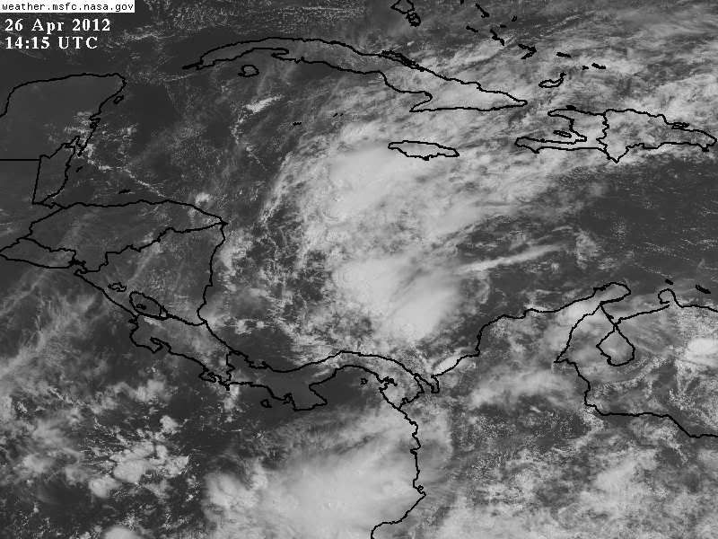
The latest IR imagery

Last edited by northjaxpro on Mon May 07, 2012 2:22 pm, edited 1 time in total.
0 likes
NEVER, EVER SAY NEVER in the tropics and weather in general, and most importantly, with life itself!!
________________________________________________________________________________________
Fay 2008 Beryl 2012 Debby 2012 Colin 2016 Hermine 2016 Julia 2016 Matthew 2016 Irma 2017 Dorian 2019
________________________________________________________________________________________
Fay 2008 Beryl 2012 Debby 2012 Colin 2016 Hermine 2016 Julia 2016 Matthew 2016 Irma 2017 Dorian 2019
Return to “USA & Caribbean Weather”
Who is online
Users browsing this forum: No registered users and 265 guests