Texas Spring 2018
Moderator: S2k Moderators
Forum rules

The posts in this forum are NOT official forecast and should not be used as such. They are just the opinion of the poster and may or may not be backed by sound meteorological data. They are NOT endorsed by any professional institution or STORM2K.
-
Brent
- S2K Supporter

- Posts: 38741
- Age: 37
- Joined: Sun May 16, 2004 10:30 pm
- Location: Tulsa Oklahoma
- Contact:
Re: Texas Spring 2018
just got back to Dallas and it does not feel like mid April
1 likes
#neversummer
-
northjaxpro

- S2K Supporter
- Posts: 8900
- Joined: Mon Sep 27, 2010 11:21 am
- Location: Jacksonville, FL
Re: Texas Spring 2018
Ntxw wrote:Another crisp, cold April morning at DFW. The wind makes it feel colder than it is. It has been rare to see a below normal month.
You can thank the -NAO for the cooler than average meteorological spring most are experiencing , including where I am in North Florida.
0 likes
NEVER, EVER SAY NEVER in the tropics and weather in general, and most importantly, with life itself!!
________________________________________________________________________________________
Fay 2008 Beryl 2012 Debby 2012 Colin 2016 Hermine 2016 Julia 2016 Matthew 2016 Irma 2017 Dorian 2019
________________________________________________________________________________________
Fay 2008 Beryl 2012 Debby 2012 Colin 2016 Hermine 2016 Julia 2016 Matthew 2016 Irma 2017 Dorian 2019
-
Haris

- Category 5

- Posts: 1814
- Joined: Mon Nov 27, 2017 8:19 pm
- Location: ( Bee Cave) West Austin, Texas
Re: Texas Spring 2018
bubba hotep wrote:1st 1/3 of May?

There are some MASSIVE model disagreements . The euro and eps camp has still 1-3” of rain for Central and N TX while the gfs gefs camp have a 1/2” or so . Which solution do y’all think is more likely ???
0 likes
Weather geek and a storm spotter in West Austin. Not a degreed meteorologist. Big snow fan. Love rain and cold! Despise heat!
-
South Texas Storms

- Professional-Met

- Posts: 4257
- Joined: Thu Jun 24, 2010 12:28 am
- Location: Houston, TX
Re: Texas Spring 2018
The Euro and EPS have been more consistent and are typically more accurate in the medium range. They also have the UKMET model in agreement as well. Plus I'm biased and want the wetter models to win
4 likes
-
Haris
- Category 5
- Posts: 1814
- Joined: Mon Nov 27, 2017 8:19 pm
- Location: ( Bee Cave) West Austin, Texas
Re: Texas Spring 2018
South Texas Storms wrote::uarrow:
The Euro and EPS have been more consistent and are typically more accurate in the medium range. They also have the UKMET model in agreement as well. Plus I'm biased and want the wetter models to win
Indeed and , the dumb gfs trended towards the euro in its 18z run!
1 likes
Weather geek and a storm spotter in West Austin. Not a degreed meteorologist. Big snow fan. Love rain and cold! Despise heat!
-
cheezyWXguy

- Category 5
- Posts: 6282
- Joined: Mon Feb 13, 2006 12:29 am
- Location: Dallas, TX
Re: Texas Spring 2018
Haris wrote:bubba hotep wrote:1st 1/3 of May?
There are some MASSIVE model disagreements . The euro and eps camp has still 1-3” of rain for Central and N TX while the gfs gefs camp have a 1/2” or so . Which solution do y’all think is more likely ???
I don't know which model camp to believe, but I will say, the GFS's shear profiles for NTX Friday night into Saturday are impressive. Large rounded hodographs, 0-3km SRH values above 500 m2/s2 at hour 138 in DFW. The major drawback to this event seems to be instability, according to both the GFS and Euro. The 12z Euro and 18z GFS also seem to be converging on the idea of a line of storms moving through at that time, but with such strong directional shear, I am reluctant to believe that activity wouldn't be discrete, or at least broken. I guess the majority of questions will be answered with time, but does anyone know why instability is forecast by both models to be so low?
0 likes
-
Brent
- S2K Supporter
- Posts: 38741
- Age: 37
- Joined: Sun May 16, 2004 10:30 pm
- Location: Tulsa Oklahoma
- Contact:
Re: Texas Spring 2018
cheezyWXguy wrote:Haris wrote:bubba hotep wrote:1st 1/3 of May?
There are some MASSIVE model disagreements . The euro and eps camp has still 1-3” of rain for Central and N TX while the gfs gefs camp have a 1/2” or so . Which solution do y’all think is more likely ???
I don't know which model camp to believe, but I will say, the GFS's shear profiles for NTX Friday night into Saturday are impressive. Large rounded hodographs, 0-3km SRH values above 500 m2/s2 at hour 138 in DFW. The major drawback to this event seems to be instability, according to both the GFS and Euro. The 12z Euro and 18z GFS also seem to be converging on the idea of a line of storms moving through at that time, but with such strong directional shear, I am reluctant to believe that activity wouldn't be discrete, or at least broken. I guess the majority of questions will be answered with time, but does anyone know why instability is forecast by both models to be so low?
i'm assuming time of day is keeping the parameters down... looks like an early morning event(plus it looks more like a big line/MCS atm). Not to say it couldn't be significant still(it is 5-6 days out and things look different by then), but that's my theory right now
0 likes
#neversummer
-
Ralph's Weather
- S2K Supporter
- Posts: 3371
- Age: 38
- Joined: Fri Dec 13, 2013 11:55 am
- Location: Lindale, TX
- Contact:
Re: Texas Spring 2018
Down to 34 at 440am it's gonna be a close call for a freeze.
2 likes
Follow on Facebook at Ralph's Weather.
-
Yukon Cornelius
- S2K Supporter
- Posts: 1842
- Age: 42
- Joined: Thu Dec 20, 2012 9:23 pm
- Location: Dean, TX/Westcliffe, CO
Re: Texas Spring 2018
Ralph's Weather wrote:Down to 34 at 440am it's gonna be a close call for a freeze.
yall beat us this morning. Only down to 39 here.
0 likes
#neversummer
-
gboudx

- S2K Supporter
- Posts: 4090
- Joined: Thu Sep 04, 2003 1:39 pm
- Location: Rockwall, Tx but from Harvey, La
Re: Texas Spring 2018
Late week storm discussion from jeff:
A powerful storm system will arrive across TX late this week/early this weekend.
Extremely nice mid April weather will continue today and tomorrow before a weak cool front slides into the area on Wednesday and stalls near the coast on Thursday. Strong capping aloft during this period should prevent much in the way of thunderstorms, but a few scattered showers will be possible from Wednesday afternoon through Thursday over the region. The front will wash out late Thursday with onshore flow developing Thursday night.
Main forecast focus this week will be on the late week/weekend time period as a strong storm system looks poised to impact the region. It should be understood that we are still several days away from any impacts and the forecast will change, but decent global model consistency is pointing toward a very active period late Friday into much of Saturday over the area. Moisture values will rise to impressive mid April levels and the jet stream structure over SE TX looks mostly favorable for strong lifting along an advancing frontal boundary. Severe thunderstorms and heavy rainfall look possible with this system given it will be further south than the recent systems to slide just NE of our area. This system deserves close watch as we move through the week.
0 likes
-
Haris
- Category 5
- Posts: 1814
- Joined: Mon Nov 27, 2017 8:19 pm
- Location: ( Bee Cave) West Austin, Texas
Re: Texas Spring 2018

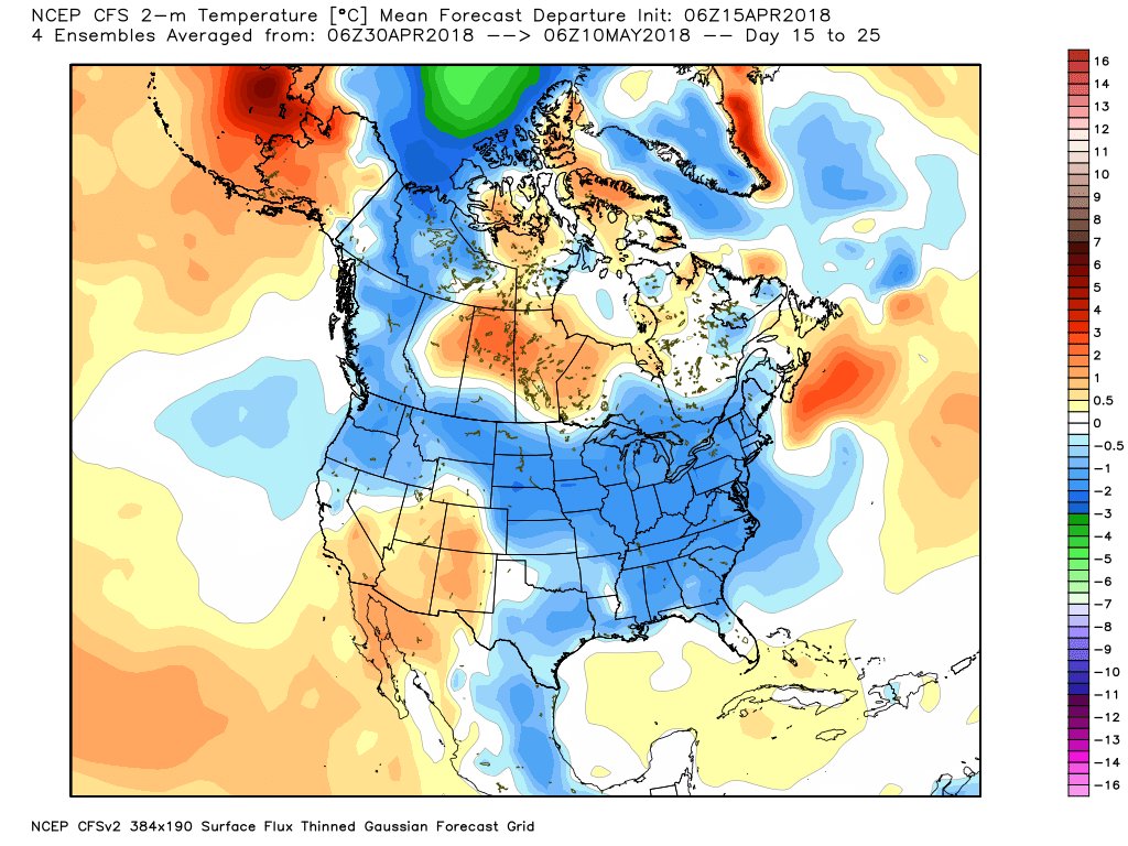
EPS precip anomalies for MAY!
5 likes
Weather geek and a storm spotter in West Austin. Not a degreed meteorologist. Big snow fan. Love rain and cold! Despise heat!
-
bubba hotep

- S2K Supporter
- Posts: 6014
- Joined: Wed Dec 28, 2016 1:00 am
- Location: Collin County Texas
Re: Texas Spring 2018
Lol Where were these runs during the winter? New Euro Weeklies are below avg temp and above avg rain...
3 likes
Winter time post are almost exclusively focused on the DFW area.
-
South Texas Storms
- Professional-Met
- Posts: 4257
- Joined: Thu Jun 24, 2010 12:28 am
- Location: Houston, TX
Re: Texas Spring 2018
bubba hotep wrote:Lol Where were these runs during the winter? New Euro Weeklies are below avg temp and above avg rain...
To me, it's more important we see cooler and wetter weather in the spring so that we can keep the death ridge of summer away.
10 likes
-
weatherdude1108
- Category 5
- Posts: 4228
- Joined: Tue Dec 13, 2011 1:04 pm
- Location: Northwest Austin/Cedar Park, TX
Re: Texas Spring 2018
South Texas Storms wrote:bubba hotep wrote:Lol Where were these runs during the winter? New Euro Weeklies are below avg temp and above avg rain...
To me, it's more important we see cooler and wetter weather in the spring so that we can keep the death ridge of summer away.
AMEN to that!
2 likes
The preceding post is NOT an official forecast, and should not be used as such. It is only the opinion of the poster and may or may not be backed by sound meteorological data. It is NOT endorsed by any professional institution including storm2k.org. For Official Information please refer to the NHC and NWS products.
-
South Texas Storms
- Professional-Met
- Posts: 4257
- Joined: Thu Jun 24, 2010 12:28 am
- Location: Houston, TX
Re: Texas Spring 2018
Potent storm system forecast to track eastward across the state this weekend bringing a heavy rain and severe threat. Surprised there isn't more chatter in here about it. SPC already has portions of central TX highlighted in the day 5 (Saturday) severe outlook.
3 likes

Re: Texas Spring 2018
South Texas Storms wrote:Potent storm system forecast to track eastward across the state this weekend bringing a heavy rain and severe threat. Surprised there isn't more chatter in here about it. SPC already has portions of central TX highlighted in the day 5 (Saturday) severe outlook.
Yea I'm pretty interested in this coming up weekend system. Just wanted to get closer to the event before getting too excited.
3 likes
Resident Rain Miser
I am a weather hobbyist living 3.5 miles south of Downtown Austin and in no way or fashion should anything I say concerning forecasts be taken seriously. Please check your local NWS for accurate weather forecasting and conditions.
I am a weather hobbyist living 3.5 miles south of Downtown Austin and in no way or fashion should anything I say concerning forecasts be taken seriously. Please check your local NWS for accurate weather forecasting and conditions.
-
cheezyWXguy
- Category 5
- Posts: 6282
- Joined: Mon Feb 13, 2006 12:29 am
- Location: Dallas, TX
Re: Texas Spring 2018
South Texas Storms wrote:Potent storm system forecast to track eastward across the state this weekend bringing a heavy rain and severe threat. Surprised there isn't more chatter in here about it. SPC already has portions of central TX highlighted in the day 5 (Saturday) severe outlook.
Agreed, it's hard to ignore the shear profiles models have been showing since wednesday or thursday last week over central and north tx for friday night into saturday. Instability is virtually non-existent, except for a brief window where values jump to about 1500 j/kg, according to both the GFS and Euro. It seems that saturday's potential, along with the instability available, are likely to be significantly hampered by periodic waves of rain that would precede any potential severe event.
I have heard at various times in the past, particularly with winter-time severe episodes, where favorable wind shear and low level moisture are able to compensate for a lack of instability though, but I don't know much about those events. Is this the type of setup that might warrant a second glance in that regard, or will we be able to just enjoy the rain?
1 likes
-
Brent
- S2K Supporter
- Posts: 38741
- Age: 37
- Joined: Sun May 16, 2004 10:30 pm
- Location: Tulsa Oklahoma
- Contact:
Re: Texas Spring 2018
I'm expecting Saturday to be more of a heavy rain event at least up here but I'm definitely getting more intrigued
0 likes
#neversummer
-
South Texas Storms
- Professional-Met
- Posts: 4257
- Joined: Thu Jun 24, 2010 12:28 am
- Location: Houston, TX
Re: Texas Spring 2018
As of now it seems like more of a heavy rain threat in north TX and a severe threat in central TX. I'm guessing based on today's data, SPC would have the Marginal Risk area in DFW with the Slight Risk area down across SA, Austin, CS, and Houston.
0 likes

Re: Texas Spring 2018
South Texas Storms wrote:As of now it seems like more of a heavy rain threat in north TX and a severe threat in central TX. I'm guessing based on today's data, SPC would have the Marginal Risk area in DFW with the Slight Risk area down across SA, Austin, CS, and Houston.
I have a question for you. The mets here in Houston are calling for 1-3” of rain across the area, but I don’t understand where they’re getting that from. The GFS is barely calling for anything across the area. I guess the Euro is different? I don’t have access to it.
0 likes
Return to “USA & Caribbean Weather”
Who is online
Users browsing this forum: Stratton23 and 24 guests