Texas Spring-2015

U.S. & Caribbean Weather Discussions and Severe Weather Events

Moderator: S2k Moderators

Forum rules

The posts in this forum are NOT official forecast and should not be used as such. They are just the opinion of the poster and may or may not be backed by sound meteorological data. They are NOT endorsed by any professional institution or STORM2K.

Help Support Storm2K
Message
Author
User avatar
cheezyWXguy
Category 5
Category 5
Posts: 6108
Joined: Mon Feb 13, 2006 12:29 am
Location: Dallas, TX

Re: Texas Spring-2015

#761 Postby cheezyWXguy » Sun Apr 26, 2015 3:41 pm

Brent wrote:
cheezyWXguy wrote:Okay so, I've noticed that the cell north of abilene is starting to become embedded in a cluster or line of storms oriented SSW to NNE. Is this the beginning stages of what is supposed to become the southeastward-moving derecho that was mentioned earlier?


That's supposed to be after 0z(aka dark) but who knows.


Ah, ok. Thanks for clarifying that (EDIT: And to you too, Ntxw) . I'm very curious to see how that evolves tonight. It seems like most of the derechos I've seen in the past move purely west to east instead of dropping southeast.
0 likes   

User avatar
Ntxw
Storm2k Moderator
Storm2k Moderator
Posts: 22785
Joined: Wed Oct 21, 2009 6:34 pm
Location: DFW, Texas

Re: Texas Spring-2015

#762 Postby Ntxw » Sun Apr 26, 2015 3:42 pm

cheezyWXguy wrote:Ah, ok. Thanks for clarifying that (EDIT: And to you too, Ntxw) . I'm very curious to see how that evolves tonight. It seems like most of the derechos I've seen in the past move purely west to east instead of dropping southeast.


Yeah the "derecho" will be moving west to east as upper lift comes out.
0 likes   
The above post and any post by Ntxw is NOT an official forecast and should not be used as such. It is just the opinion of the poster and may or may not be backed by sound meteorological data. It is NOT endorsed by any professional institution including Storm2k. For official information, please refer to NWS products.

  Help support Storm2K!
Help Support Storm2K

User avatar
Texas Snowman
Storm2k Moderator
Storm2k Moderator
Posts: 6179
Joined: Fri Jan 25, 2008 11:29 am
Location: Denison, Texas

Re: Texas Spring-2015

#763 Postby Texas Snowman » Sun Apr 26, 2015 3:42 pm

Larry Mowry's Twitter feed:

Image
0 likes   
The above post and any post by Texas Snowman is NOT an official forecast and should not be used as such. It is just the opinion of the poster and may or may not be backed by sound meteorological data. It is NOT endorsed by any professional institution including storm2k.org. For official information, please refer to NWS products.

Brent
S2K Supporter
S2K Supporter
Posts: 38089
Age: 36
Joined: Sun May 16, 2004 10:30 pm
Location: Tulsa Oklahoma
Contact:

Re: Texas Spring-2015

#764 Postby Brent » Sun Apr 26, 2015 3:45 pm

Just to further explain it, this is round 2 starting up... the "derecho" talk is round 3:

'Image
0 likes   
#neversummer

User avatar
Ntxw
Storm2k Moderator
Storm2k Moderator
Posts: 22785
Joined: Wed Oct 21, 2009 6:34 pm
Location: DFW, Texas

Re: Texas Spring-2015

#765 Postby Ntxw » Sun Apr 26, 2015 3:47 pm

SEVERE WEATHER STATEMENT
NATIONAL WEATHER SERVICE FORT WORTH TX
334 PM CDT SUN APR 26 2015

TXC093-262100-
/O.CON.KFWD.TO.W.0005.000000T0000Z-150426T2100Z/
COMANCHE TX-
334 PM CDT SUN APR 26 2015

...A TORNADO WARNING REMAINS IN EFFECT UNTIL 400 PM CDT FOR CENTRAL
COMANCHE COUNTY...

AT 334 PM CDT...A CONFIRMED LARGE AND EXTREMELY DANGEROUS TORNADO WAS
LOCATED NEAR MAY...OR 16 MILES NORTHWEST OF COMANCHE...MOVING EAST AT
25 MPH.


THIS IS A PARTICULARLY DANGEROUS SITUATION.

HAZARD...DAMAGING TORNADO.

SOURCE...WEATHER SPOTTERS CONFIRMED TORNADO.

IMPACT...YOU ARE IN A LIFE THREATENING SITUATION. FLYING DEBRIS MAY
BE DEADLY TO THOSE CAUGHT WITHOUT SHELTER. MOBILE HOMES
WILL BE DESTROYED. CONSIDERABLE DAMAGE TO
HOMES...BUSINESSES AND VEHICLES IS LIKELY AND COMPLETE
DESTRUCTION IS POSSIBLE.

LOCATIONS IMPACTED INCLUDE...
COMANCHE AND DE LEON.
0 likes   
The above post and any post by Ntxw is NOT an official forecast and should not be used as such. It is just the opinion of the poster and may or may not be backed by sound meteorological data. It is NOT endorsed by any professional institution including Storm2k. For official information, please refer to NWS products.


  Help support Storm2K!

Help Support Storm2K


User avatar
cheezyWXguy
Category 5
Category 5
Posts: 6108
Joined: Mon Feb 13, 2006 12:29 am
Location: Dallas, TX

Re: Texas Spring-2015

#766 Postby cheezyWXguy » Sun Apr 26, 2015 3:47 pm

Ntxw wrote:
cheezyWXguy wrote:Okay so, I've noticed that the cell north of abilene is starting to become embedded in a cluster or line of storms oriented SSW to NNE. Is this the beginning stages of what is supposed to become the southeastward-moving derecho that was mentioned earlier?


Not yet, northeast movement overall it seems. A bigger line will form late this evening further west. HRRR is depicting a few more supercells (one over the same area being hit now, Brown, Erath, Comanche counties etc. However HRRR is not the best model of late.


Interesting you say that about the HRRR, as the SPC included this in one of their recent mesoscale discussions:

--- NOTE ---
RAP MODEL HAS HAD A SUBSTANTIAL DRYING/OVER-MIXING PROBLEM OVER MUCH
OF CENTRAL TX AND SRN OK ALL DAY LONG. THIS APPEARS TO BE STRONGLY
AFFECTING MOISTURE FIELDS AND AUTOMATED ANALYSES OF PARAMETERS
DEPENDENT ON MOISTURE. USE BUOYANCY/MOISTURE/CONVECTIVE PROGS FROM
RAP...RAP-DEPENDENT HRRR...AND SPC/SFCOA FIELDS...WITH GREAT
CAUTION.

Does this mean that it is underdoing the activity that is expected in the central texas later on?
0 likes   

User avatar
Texas Snowman
Storm2k Moderator
Storm2k Moderator
Posts: 6179
Joined: Fri Jan 25, 2008 11:29 am
Location: Denison, Texas

#767 Postby Texas Snowman » Sun Apr 26, 2015 3:47 pm

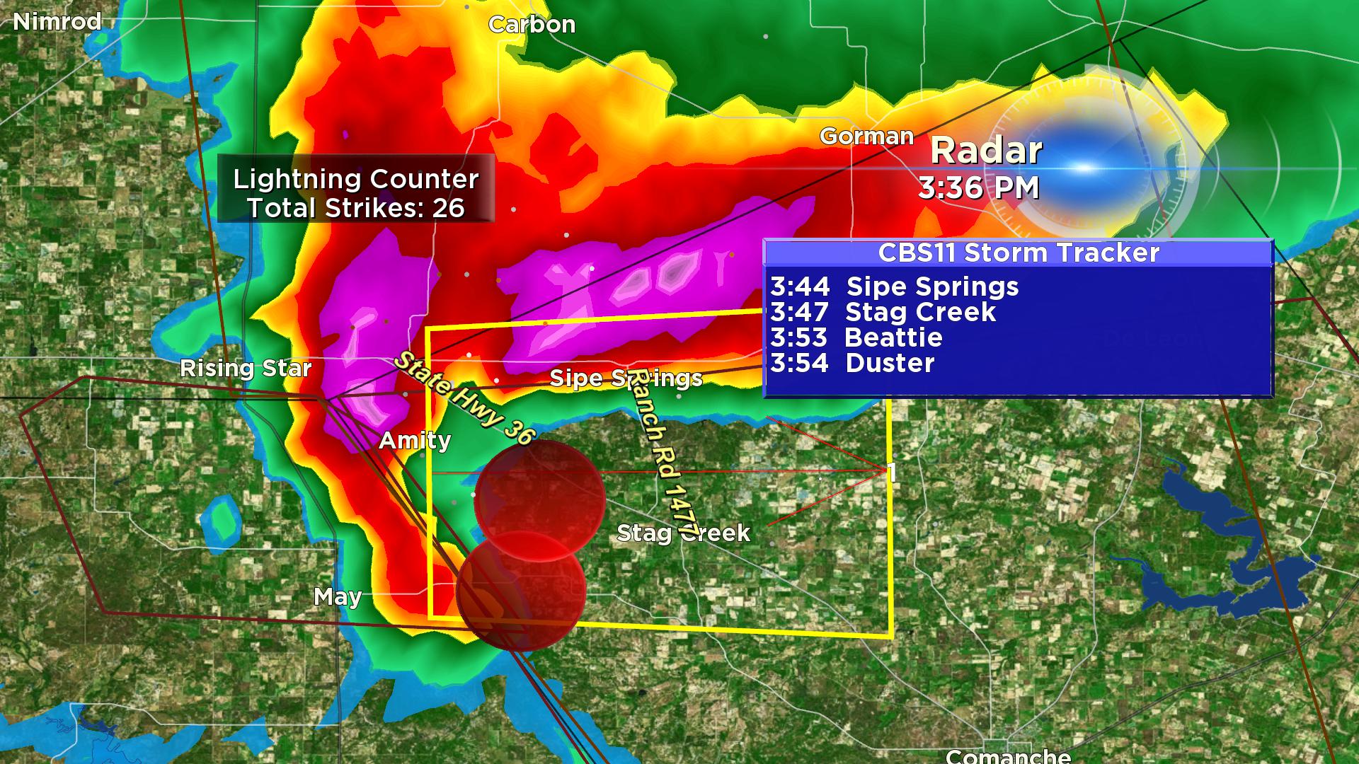
Weather Channel Tweet says debris is detected in the tornado near May.
0 likes   
The above post and any post by Texas Snowman is NOT an official forecast and should not be used as such. It is just the opinion of the poster and may or may not be backed by sound meteorological data. It is NOT endorsed by any professional institution including storm2k.org. For official information, please refer to NWS products.

User avatar
Texas Snowman
Storm2k Moderator
Storm2k Moderator
Posts: 6179
Joined: Fri Jan 25, 2008 11:29 am
Location: Denison, Texas

#768 Postby Texas Snowman » Sun Apr 26, 2015 3:48 pm

This is going to be a really close call for Deleon and Dublin if it stays on the ground.
0 likes   
The above post and any post by Texas Snowman is NOT an official forecast and should not be used as such. It is just the opinion of the poster and may or may not be backed by sound meteorological data. It is NOT endorsed by any professional institution including storm2k.org. For official information, please refer to NWS products.

Brent
S2K Supporter
S2K Supporter
Posts: 38089
Age: 36
Joined: Sun May 16, 2004 10:30 pm
Location: Tulsa Oklahoma
Contact:

Re: Texas Spring-2015

#769 Postby Brent » Sun Apr 26, 2015 3:49 pm

Image

Steve McCauley says as long as this map holds any rotations will weaken approaching the metroplex
0 likes   
#neversummer

User avatar
Texas Snowman
Storm2k Moderator
Storm2k Moderator
Posts: 6179
Joined: Fri Jan 25, 2008 11:29 am
Location: Denison, Texas

#770 Postby Texas Snowman » Sun Apr 26, 2015 3:51 pm

Pete Delkus/WFAA tweet:

"Latest tornado info out of Comanche County: tornado on the ground 4mi north of Sidney (9mi NW of Comanche). Moving E/30 mph. #wfaaweather"
0 likes   
The above post and any post by Texas Snowman is NOT an official forecast and should not be used as such. It is just the opinion of the poster and may or may not be backed by sound meteorological data. It is NOT endorsed by any professional institution including storm2k.org. For official information, please refer to NWS products.

User avatar
Texas Snowman
Storm2k Moderator
Storm2k Moderator
Posts: 6179
Joined: Fri Jan 25, 2008 11:29 am
Location: Denison, Texas

#771 Postby Texas Snowman » Sun Apr 26, 2015 3:54 pm

Larry Mowry:

"LARGE TORNADO near Beattie and DeLeon in Comanche County moving east at 25 mph."
0 likes   
The above post and any post by Texas Snowman is NOT an official forecast and should not be used as such. It is just the opinion of the poster and may or may not be backed by sound meteorological data. It is NOT endorsed by any professional institution including storm2k.org. For official information, please refer to NWS products.

WeatherGuesser
Category 5
Category 5
Posts: 2672
Joined: Tue Jun 29, 2010 6:46 am

#772 Postby WeatherGuesser » Sun Apr 26, 2015 3:55 pm

Image
0 likes   

User avatar
Texas Snowman
Storm2k Moderator
Storm2k Moderator
Posts: 6179
Joined: Fri Jan 25, 2008 11:29 am
Location: Denison, Texas

#773 Postby Texas Snowman » Sun Apr 26, 2015 3:55 pm

:uarrow: Deleon has about 2,500 residents, Dublin has about 3,500 residents.
0 likes   
The above post and any post by Texas Snowman is NOT an official forecast and should not be used as such. It is just the opinion of the poster and may or may not be backed by sound meteorological data. It is NOT endorsed by any professional institution including storm2k.org. For official information, please refer to NWS products.

User avatar
TheProfessor
Professional-Met
Professional-Met
Posts: 3506
Age: 28
Joined: Tue Dec 03, 2013 10:56 am
Location: Wichita, Kansas

#774 Postby TheProfessor » Sun Apr 26, 2015 3:58 pm

Looks like these storms are going to miss DFW, seems like we are going to escape round 2 here.
0 likes   
An alumnus of The Ohio State University.

Your local National Weather Service office is your best source for weather information.

User avatar
Texas Snowman
Storm2k Moderator
Storm2k Moderator
Posts: 6179
Joined: Fri Jan 25, 2008 11:29 am
Location: Denison, Texas

#775 Postby Texas Snowman » Sun Apr 26, 2015 3:59 pm

PDS warning, no tornado emergency now for Comanche, Deleon:

"TORNADO WARNING
TXC093-262145-
/O.NEW.KFWD.TO.W.0006.150426T2056Z-150426T2145Z/

BULLETIN - EAS ACTIVATION REQUESTED
TORNADO WARNING
NATIONAL WEATHER SERVICE FORT WORTH TX
356 PM CDT SUN APR 26 2015

THE NATIONAL WEATHER SERVICE IN FORT WORTH HAS ISSUED A

* TORNADO WARNING FOR...
CENTRAL COMANCHE COUNTY IN CENTRAL TEXAS...

* UNTIL 445 PM CDT

* AT 356 PM CDT...A CONFIRMED LARGE AND EXTREMELY DANGEROUS TORNADO
WAS LOCATED 7 MILES NORTHWEST OF COMANCHE...MOVING EAST AT 30 MPH.

THIS IS A PARTICULARLY DANGEROUS SITUATION.

HAZARD...DAMAGING TORNADO.

SOURCE...WEATHER SPOTTERS CONFIRMED TORNADO.

IMPACT...YOU ARE IN A LIFE THREATENING SITUATION. FLYING DEBRIS
MAY BE DEADLY TO THOSE CAUGHT WITHOUT SHELTER. MOBILE
HOMES WILL BE DESTROYED. CONSIDERABLE DAMAGE TO
HOMES...BUSINESSES AND VEHICLES IS LIKELY AND COMPLETE
DESTRUCTION IS POSSIBLE.

* THE TORNADO WILL BE NEAR...
COMANCHE AROUND 405 PM CDT.

PRECAUTIONARY/PREPAREDNESS ACTIONS...

TO REPEAT...A LARGE...EXTREMELY DANGEROUS AND POTENTIALLY DEADLY
TORNADO IS ON THE GROUND. TO PROTECT YOUR LIFE...TAKE COVER NOW! MOVE
TO A BASEMENT OR AN INTERIOR ROOM ON THE LOWEST FLOOR OF A STURDY
BUILDING. AVOID WINDOWS. IF YOU ARE OUTDOORS...IN A MOBILE HOME...OR
IN A VEHICLE...MOVE TO THE CLOSEST SUBSTANTIAL SHELTER AND PROTECT
YOURSELF FROM FLYING DEBRIS.

&&

LAT...LON 3210 9864 3212 9845 3194 9833 3184 9830
3185 9869 3201 9875
TIME...MOT...LOC 2056Z 265DEG 24KT 3199 9867

TORNADO...OBSERVED
TORNADO DAMAGE THREAT...CONSIDERABLE
HAIL...4.25IN

$$

CAVANAUGH/SCHROEDER"
0 likes   
The above post and any post by Texas Snowman is NOT an official forecast and should not be used as such. It is just the opinion of the poster and may or may not be backed by sound meteorological data. It is NOT endorsed by any professional institution including storm2k.org. For official information, please refer to NWS products.

WeatherGuesser
Category 5
Category 5
Posts: 2672
Joined: Tue Jun 29, 2010 6:46 am

#776 Postby WeatherGuesser » Sun Apr 26, 2015 4:00 pm

* TORNADO WARNING FOR...
CENTRAL COMANCHE COUNTY IN CENTRAL TEXAS...

* UNTIL 445 PM CDT

* AT 356 PM CDT...A CONFIRMED LARGE AND EXTREMELY DANGEROUS TORNADO
WAS LOCATED 7 MILES NORTHWEST OF COMANCHE...MOVING EAST AT 30 MPH.

THIS IS A PARTICULARLY DANGEROUS SITUATION.

HAZARD...DAMAGING TORNADO.

SOURCE...WEATHER SPOTTERS CONFIRMED TORNADO.

IMPACT...YOU ARE IN A LIFE THREATENING SITUATION. FLYING DEBRIS
MAY BE DEADLY TO THOSE CAUGHT WITHOUT SHELTER. MOBILE
HOMES WILL BE DESTROYED. CONSIDERABLE DAMAGE TO
HOMES...BUSINESSES AND VEHICLES IS LIKELY AND COMPLETE
DESTRUCTION IS POSSIBLE.

* THE TORNADO WILL BE NEAR...
COMANCHE AROUND 405 PM CDT.
0 likes   

User avatar
Texas Snowman
Storm2k Moderator
Storm2k Moderator
Posts: 6179
Joined: Fri Jan 25, 2008 11:29 am
Location: Denison, Texas

#777 Postby Texas Snowman » Sun Apr 26, 2015 4:01 pm

Going between Comanche and Deleon it looks like to me.

Dublin could be - COULD BE - in the direct path however if motion continues.
0 likes   
The above post and any post by Texas Snowman is NOT an official forecast and should not be used as such. It is just the opinion of the poster and may or may not be backed by sound meteorological data. It is NOT endorsed by any professional institution including storm2k.org. For official information, please refer to NWS products.

WeatherGuesser
Category 5
Category 5
Posts: 2672
Joined: Tue Jun 29, 2010 6:46 am

#778 Postby WeatherGuesser » Sun Apr 26, 2015 4:04 pm

Looks like VanDyke and Proctor

Maybe Downing
0 likes   

User avatar
Texas Snowman
Storm2k Moderator
Storm2k Moderator
Posts: 6179
Joined: Fri Jan 25, 2008 11:29 am
Location: Denison, Texas

#779 Postby Texas Snowman » Sun Apr 26, 2015 4:06 pm

Baseball sized hail in Deleon as per Channel 11
0 likes   
The above post and any post by Texas Snowman is NOT an official forecast and should not be used as such. It is just the opinion of the poster and may or may not be backed by sound meteorological data. It is NOT endorsed by any professional institution including storm2k.org. For official information, please refer to NWS products.

User avatar
Texas Snowman
Storm2k Moderator
Storm2k Moderator
Posts: 6179
Joined: Fri Jan 25, 2008 11:29 am
Location: Denison, Texas

#780 Postby Texas Snowman » Sun Apr 26, 2015 4:08 pm

SevereStudios ‏@severestudios
4:04pm - Spotter report: Tornado 3 miles south of De Leon, TX.
DUBLIN, TX should be in shelter!
0 likes   
The above post and any post by Texas Snowman is NOT an official forecast and should not be used as such. It is just the opinion of the poster and may or may not be backed by sound meteorological data. It is NOT endorsed by any professional institution including storm2k.org. For official information, please refer to NWS products.


Return to “USA & Caribbean Weather”

Who is online

Users browsing this forum: Cpv17, opticsguy and 12 guests