Texas Spring 2025

U.S. & Caribbean Weather Discussions and Severe Weather Events

Moderator: S2k Moderators

Forum rules

The posts in this forum are NOT official forecast and should not be used as such. They are just the opinion of the poster and may or may not be backed by sound meteorological data. They are NOT endorsed by any professional institution or STORM2K.

Help Support Storm2K
Message
Author
User avatar
South Texas Storms
Professional-Met
Professional-Met
Posts: 4226
Joined: Thu Jun 24, 2010 12:28 am
Location: Houston, TX

Re: Texas Spring 2025

#841 Postby South Texas Storms » Sun Apr 27, 2025 4:34 pm

Cpv17 wrote:
txtwister78 wrote:I've often said when we're under these long droughts we typically bust out with a flooding event of some sort (whether it be pattern driven or of tropical origin).

While I'm not suggesting we're about to cash in to a point where the drought is completely erased (that would take some doing and probably too much of a good thing), I do continue to feel good about the opportunities on the table that lie ahead next week and perhaps beyond. Lots to watch over the coming days.


That’s promising coming from a very conservative person like yourself.


I'll be very surprised if you get less than 1 inch in the next 10 days. Should have several rounds of good rain chances through early May.
1 likes   

User avatar
wxman22
Category 5
Category 5
Posts: 1492
Joined: Mon Jan 30, 2006 12:39 am
Location: Wichita Falls, TX
Contact:

Re: Texas Spring 2025

#842 Postby wxman22 » Sun Apr 27, 2025 4:48 pm

An Enhanced Risk may be needed Tuesday, per the SPC Day 3 afternoon discussion. This stormy pattern has been almost non stop since mid April up here with over 6 inches of rain this month so far. We could make a run at 10 inches for the month depending on where the heaviest rains end up this week. Hopefully as we move into May the heavier rains will expand further south into the state.

Image


...TX/OK...
Multiple rounds of thunderstorms are expected through the period
along a convectively modulated, quasi-stationary baroclinic zone.
This renders enough uncertainty to mitigate a corridor of greater
severe potential, but a mesoscale-driven Enhanced Risk may be needed
in later outlooks. Adequate mid-level southwesterlies will persist
through the period for supercells, with most guidance hinting at
training convection along the west/southwest to east-northeast
oriented portion of the zone near the Red River. More probable
scenario for very large hail should exist to the southwest of that
corridor, with a few dryline supercells favored in the late
afternoon to early evening.


..Grams.. 04/27/2025


Image
0 likes   

Stratton23
Category 5
Category 5
Posts: 2521
Joined: Fri Jul 21, 2023 10:59 pm
Location: Katy, Tx

Re: Texas Spring 2025

#843 Postby Stratton23 » Mon Apr 28, 2025 12:56 am

That Euro 00z run is an absolute doozy
0 likes   

User avatar
wxman22
Category 5
Category 5
Posts: 1492
Joined: Mon Jan 30, 2006 12:39 am
Location: Wichita Falls, TX
Contact:

Re: Texas Spring 2025

#844 Postby wxman22 » Mon Apr 28, 2025 8:19 am

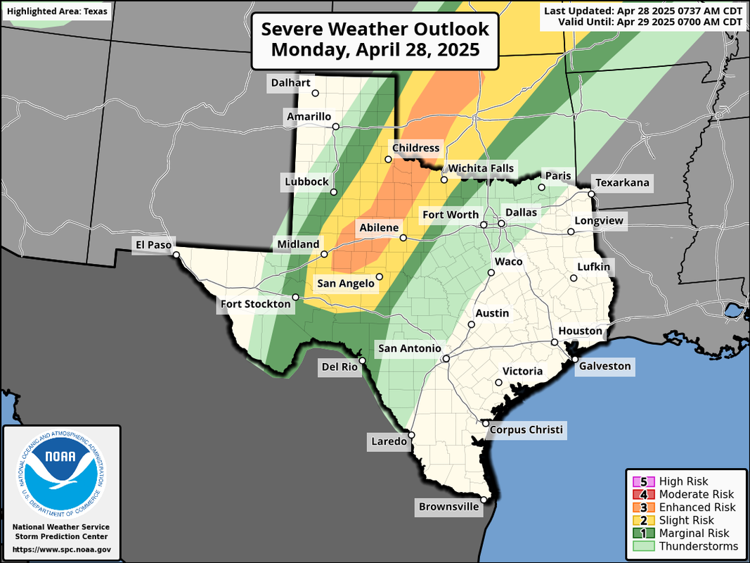
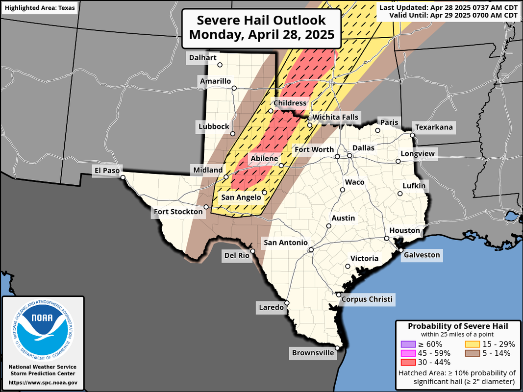
Enhanced Risk issued today.

Image

Image

Image
0 likes   

User avatar
Edwards Limestone
S2K Supporter
S2K Supporter
Posts: 476
Age: 36
Joined: Tue Dec 28, 2021 11:05 am
Location: Smithson Valley, TX

Re: Texas Spring 2025

#845 Postby Edwards Limestone » Mon Apr 28, 2025 11:34 am

Based on the ensembles, the bullseye for this week/next week's precip looks to be N/NE TX and Oklahoma.
0 likes   
The above post is NOT an official forecast and should not be used as such. It is just the opinion of the poster and may or may not be backed by sound meteorological data. It is NOT endorsed by any professional institution including Storm2k. For official information, please refer to NWS products.

User avatar
ElectricStorm
Category 5
Category 5
Posts: 5044
Age: 24
Joined: Tue Aug 13, 2019 11:23 pm
Location: Skiatook, OK / Norman, OK

Re: Texas Spring 2025

#846 Postby ElectricStorm » Mon Apr 28, 2025 12:09 pm

For OK/TX, probably going to see splitting supercells as we approach 0z (and probably into the night) Best chance for a tornado might be near the Red River around Wichita Falls or a little west. SPC added a small 10# area at the 13z update but removed it at the previous update. Honestly surprised it was even added in the first place as that area seems too far west for sigtor potential to me but we'll see. Probably going to see at least some big hailers and probably a couple tors. Luckily forcing in very weak down here compared to further north otherwise this would be a much more dangerous event.
0 likes   
B.S Meteorology, University of Oklahoma '25

Please refer to the NHC, NWS, or SPC for official information.

User avatar
wxman22
Category 5
Category 5
Posts: 1492
Joined: Mon Jan 30, 2006 12:39 am
Location: Wichita Falls, TX
Contact:

Re: Texas Spring 2025

#847 Postby wxman22 » Mon Apr 28, 2025 12:52 pm

Afternoon update

Image

OK/TX...
Strong heating occurring along a dryline that will extend from
western OK into west TX. Large-scale forcing mechanisms are weak
across this region, but a consensus of CAM solutions show scattered
intense thunderstorm development over southwest OK/northwest TX by
mid-afternoon, and further development southward during the evening.
Very large hail and a few tornadoes are possible across this region.
0 likes   

User avatar
wxman22
Category 5
Category 5
Posts: 1492
Joined: Mon Jan 30, 2006 12:39 am
Location: Wichita Falls, TX
Contact:

Re: Texas Spring 2025

#848 Postby wxman22 » Mon Apr 28, 2025 3:42 pm

Image


Mesoscale Discussion 0588
NWS Storm Prediction Center Norman OK
0333 PM CDT Mon Apr 28 2025

Areas affected...Edwards Plateau into western/central Oklahoma

Concerning...Severe potential...Tornado Watch likely

Valid 282033Z - 282300Z

Probability of Watch Issuance...80 percent

SUMMARY...A tornado watch will likely be needed this afternoon as
storms are expected to develop along the dryline in the next 2-3
hours. All severe hazards will be possible. The tornado threat will
steadily increase from late afternoon into the evening.

DISCUSSION...Signs of mid-level ascent have been evident across the
southern Plains with visible satellite showing increasing amounts of
mid/high-level clouds moving in from the southwest. As a shortwave
perturbation lifts northeastward this afternoon/evening, this ascent
and additional surface heating should erode capping along/near the
dryline. A high-based storm has already formed northeast of Fort
Stockton in the last hour. Additional storms are expected to develop
later this afternoon, perhaps within the next 2-3 hours.

The environment will be quite favorable for supercells capable of
all severe hazards. Very steep mid-level lapse rates were observed
within the High Plains region on this mornings soundings. Large to
potentially giant hail will be possible along with severe winds.
Tornadoes will also be possible, particularly from southwest
Oklahoma into the Texas Rolling Plains where dewpoints have remained
in the upper 60s/low 70s F. The tornado threat will steadily
increase with time as 850 mb winds increase east of the dryline from
late afternoon into the evening. A strong tornado cannot be ruled
out within this more favorable mesoscale zone.

..Wendt/Hart.. 04/28/2025
0 likes   

User avatar
wxman22
Category 5
Category 5
Posts: 1492
Joined: Mon Jan 30, 2006 12:39 am
Location: Wichita Falls, TX
Contact:

Re: Texas Spring 2025

#849 Postby wxman22 » Mon Apr 28, 2025 4:07 pm

Image
0 likes   

Brent
S2K Supporter
S2K Supporter
Posts: 38090
Age: 36
Joined: Sun May 16, 2004 10:30 pm
Location: Tulsa Oklahoma
Contact:

Re: Texas Spring 2025

#850 Postby Brent » Mon Apr 28, 2025 5:58 pm

Looks like somebody up here is gonna make a run for the wettest April ever yikes. Tulsa only needs about 3 inches
1 likes   
#neversummer

User avatar
wxman22
Category 5
Category 5
Posts: 1492
Joined: Mon Jan 30, 2006 12:39 am
Location: Wichita Falls, TX
Contact:

Re: Texas Spring 2025

#851 Postby wxman22 » Mon Apr 28, 2025 7:03 pm

Image
0 likes   

Brent
S2K Supporter
S2K Supporter
Posts: 38090
Age: 36
Joined: Sun May 16, 2004 10:30 pm
Location: Tulsa Oklahoma
Contact:

Re: Texas Spring 2025

#852 Postby Brent » Mon Apr 28, 2025 8:20 pm

And there it is... Someone just posted about historic flooding here :spam:
0 likes   
#neversummer

User avatar
ElectricStorm
Category 5
Category 5
Posts: 5044
Age: 24
Joined: Tue Aug 13, 2019 11:23 pm
Location: Skiatook, OK / Norman, OK

Re: Texas Spring 2025

#853 Postby ElectricStorm » Mon Apr 28, 2025 11:11 pm

Severe thunderstorm warning with hail here now
0 likes   
B.S Meteorology, University of Oklahoma '25

Please refer to the NHC, NWS, or SPC for official information.

WeatherNewbie
Tropical Storm
Tropical Storm
Posts: 231
Joined: Mon Mar 22, 2010 3:42 pm
Location: Richardson, Texas

Re: Texas Spring 2025

#854 Postby WeatherNewbie » Tue Apr 29, 2025 12:31 am

That line between midland and Lubbock looks nasty.
0 likes   
The above post is NOT an official forecast and should not be used as such. It is just the opinion of the poster and may or may not be backed by sound meteorological data. It is NOT endorsed by any professional institution including storm2k.org. For official information, please refer to NWS products.

User avatar
wxman22
Category 5
Category 5
Posts: 1492
Joined: Mon Jan 30, 2006 12:39 am
Location: Wichita Falls, TX
Contact:

Re: Texas Spring 2025

#855 Postby wxman22 » Tue Apr 29, 2025 7:22 am

Another Enhanced Risk issued today.

Image

West TX into the Ozarks...
Multiple rounds of thunderstorms are expected across the southern
Plains in the vicinity of the surface front, with widely scattered
diurnal development also possible along the southward trailing
dryline into the Permian Basin vicinity. Strong midlevel flow east
of the Southwest trough will provide sufficient deep-layer shear for
storm organization, within a moderate to strongly unstable
environment near/south of the front. Occasional supercells will be
possible, with a threat of large to very large hail, severe gusts,
and a few tornadoes. One or more clusters are likely to develop and
spread eastward, which could provide localized swaths of more
concentrated strong/severe gusts. The favored corridor of any such
clusters remains somewhat uncertain, with the front expected to
gradually sag south with time.
0 likes   

User avatar
Iceresistance
Category 5
Category 5
Posts: 9288
Age: 21
Joined: Sat Oct 10, 2020 9:45 am
Location: Tecumseh, OK/Norman, OK

Re: Texas Spring 2025

#856 Postby Iceresistance » Tue Apr 29, 2025 9:29 am

Sorry for no posting, but last night was WILD, I had quarter sized hail from a storm that went over me. I also managed to film the lightning from last night. I will post the video and the hail pictures when it's all set and done
0 likes   
Bill 2015 & Beta 2020

Winter 2020-2021 :cold:

All observations are in Tecumseh, OK unless otherwise noted.

Winter posts are focused mainly for Oklahoma & Texas.

Take any of my forecasts with a grain of salt, refer to the NWS, SPC, and NHC for official information

Never say Never with weather! Because ANYTHING is possible!

Tejas89
Category 1
Category 1
Posts: 429
Joined: Mon Dec 28, 2009 9:25 pm
Location: DFW, TX

Re: Texas Spring 2025

#857 Postby Tejas89 » Tue Apr 29, 2025 9:30 am

Good article on the front page of the DMN this past Sunday about how the country’s dividing line between the arid west and humid east is shifting eastward from the 100th parallel and now sits on top of major metros like DFW and Austin.

One of the takeaways…Texas can expect summer to expand to April to November by the end of the century with droughts and 100* days continuing to increase.

Also some interesting background on John Wesley Powell and how he influenced govt policy on climate in the late 1800s. Worth a read!
0 likes   

User avatar
wxman22
Category 5
Category 5
Posts: 1492
Joined: Mon Jan 30, 2006 12:39 am
Location: Wichita Falls, TX
Contact:

Re: Texas Spring 2025

#858 Postby wxman22 » Tue Apr 29, 2025 9:46 am

Higher Tornado probabilities may be needed today per SPC.

Another round of thunderstorms is anticipated this afternoon both
along the outflow-modulated cold front in OK and northwest TX and
along the dryline in West TX as the airmass destabilizes. Strong
buoyancy and shear will support supercells, particularly from west
TX into southwest OK during the late afternoon where low-level
convergence will be strongest. Large to very large hail will be the
primary threat initially, but strong cold pools and close storm
proximity should result in several clusters capable of strong to
significant gusts. A mesoscale corridor of greater tornado potential
may materialize just east of the surface low where stronger
southeasterly low-level flow and higher low-level moisture may
overlap. Current guidance suggests this would be over northwest TX,
but uncertainty exists regarding the outflow/cold front and surface
low positions, precluding the confidence needed to outlook higher
tornado probabilities.


Image
0 likes   

User avatar
txtwister78
Category 5
Category 5
Posts: 1855
Joined: Wed Jan 30, 2019 12:56 pm
Location: San Antonio

Re: Texas Spring 2025

#859 Postby txtwister78 » Tue Apr 29, 2025 11:59 am

Appears tomorrow will be a conditional day for severe weather down across SC TX, specifically around the SA metro points east with the surging dryline from the west. Better dynamics to work with to our NE with the frontal boundary up there, however with some of the severe weather parameters in place tomorrow further south, should we get a storm or two to fire along the dryline, we could see some big damaging hail.

Current hi-res models as expected with that kind of setup are going to be hit or miss so definitely a day to watch real-time trends.
Last edited by txtwister78 on Tue Apr 29, 2025 12:06 pm, edited 1 time in total.
0 likes   

User avatar
South Texas Storms
Professional-Met
Professional-Met
Posts: 4226
Joined: Thu Jun 24, 2010 12:28 am
Location: Houston, TX

Re: Texas Spring 2025

#860 Postby South Texas Storms » Tue Apr 29, 2025 12:06 pm

txtwister78 wrote:Appears tomorrow will be a conditional day for severe weather down across SC TX, specifically around the SA metro points east with the surging dryline from the west. Better dynamics to work with to our NE with the frontal boundary up there, however with some of the severe weather parameters in place tomorrow further south, should we get a storm or two to fire along the dryline, we could see some big damaging hail with any storm that manages to develop.

Current hi-res models as expected with that kind of setup are going to be hit or miss so definitely a day to watch real-time trends.


I'm not expecting much tomorrow south of north TX, but better chances will likely expand southward as a cold front pushes through Thursday into Friday. Still like you said, if anything pops tomorrow it could be strong to severe.
1 likes   


Return to “USA & Caribbean Weather”

Who is online

Users browsing this forum: No registered users and 19 guests