Texas Spring 2018

U.S. & Caribbean Weather Discussions and Severe Weather Events

Moderator: S2k Moderators

Forum rules

The posts in this forum are NOT official forecast and should not be used as such. They are just the opinion of the poster and may or may not be backed by sound meteorological data. They are NOT endorsed by any professional institution or STORM2K.

Help Support Storm2K
Message
Author
User avatar
cheezyWXguy
Category 5
Category 5
Posts: 6108
Joined: Mon Feb 13, 2006 12:29 am
Location: Dallas, TX

Re: Texas Spring 2018

#921 Postby cheezyWXguy » Sat Apr 28, 2018 3:01 pm

Haris wrote:http://i67.tinypic.com/aky0zd.png

Eps remain consistent . I guess gfs is an outlier


Im not surprised. The GFS and Euro look very different at the 500mb level. Euro has the main trough more neutral, almost negative compared to the very positive titled GFS. Euro would naturally be able to fetch more moisture north across the state.
0 likes   

User avatar
Kingarabian
S2K Supporter
S2K Supporter
Posts: 15980
Joined: Sat Aug 08, 2009 3:06 am
Location: Honolulu, Hawaii

Re: Texas Spring 2018

#922 Postby Kingarabian » Sun Apr 29, 2018 4:04 am

Think the reason why there's a discrepancy between the GFS and the Euro is due to their handling of the MJO. GFS has been consistently getting the SOI wrong for the past couple of day likely due to it wanting to take the MJO out of phase 1. Has much lower pressures over Australia compared to the Euro, thus a more positive SOI and verifying poorly. The Euro continues to show a negative SOI for the next 7 days and has been correctly forecasting a negative SOI phase. Likely due to amplifying the MJO further as it sits in phase 1. MJO phase 1 would mean a wetter pattern for most of the CONUS. So maybe that's why the GFS is showing a drier weather pattern for Texas and the Euro is the opposite.
3 likes   
RIP Kobe Bryant

User avatar
bubba hotep
S2K Supporter
S2K Supporter
Posts: 5837
Joined: Wed Dec 28, 2016 1:00 am
Location: Collin County Texas

Re: Texas Spring 2018

#923 Postby bubba hotep » Sun Apr 29, 2018 10:58 am

It looks like Wednesday will be the day with the biggest potential. SPC has expanded things southward from earlier outlooks but the WSI index shows that there is still some possibility for southward expansion into North Central Texas.

Older SPC outlook:

Image

Newest:

Image

WSI:

Image

NWS FWD:

Image
0 likes   
Winter time post are almost exclusively focused on the DFW area.

User avatar
Haris
Category 5
Category 5
Posts: 1810
Joined: Mon Nov 27, 2017 8:19 pm
Location: ( Bee Cave) West Austin, Texas

Re: Texas Spring 2018

#924 Postby Haris » Sun Apr 29, 2018 11:25 am

Image

It may not be too much but I won’t complain . Gfs starting to be consistent on this number
0 likes   
Weather geek and a storm spotter in West Austin. Not a degreed meteorologist. Big snow fan. Love rain and cold! Despise heat!

User avatar
Haris
Category 5
Category 5
Posts: 1810
Joined: Mon Nov 27, 2017 8:19 pm
Location: ( Bee Cave) West Austin, Texas

Re: Texas Spring 2018

#925 Postby Haris » Sun Apr 29, 2018 11:27 am

Image

Also, you know how the euro earlier had a cutoff low (2) and had rain in W TX for days. Well, the latest gfs now has that
3 likes   
Weather geek and a storm spotter in West Austin. Not a degreed meteorologist. Big snow fan. Love rain and cold! Despise heat!

User avatar
Haris
Category 5
Category 5
Posts: 1810
Joined: Mon Nov 27, 2017 8:19 pm
Location: ( Bee Cave) West Austin, Texas

Re: Texas Spring 2018

#926 Postby Haris » Sun Apr 29, 2018 11:30 am

EWX long term

On Wednesday the Great Basin upper trough nudges eastward to bring a
slightly more SSW-NNE flow aloft over TX, setting the table for
increasing pwat values and decreasing cap strength for late Wednesday
into the following few days. A fairly longwave pattern over TX
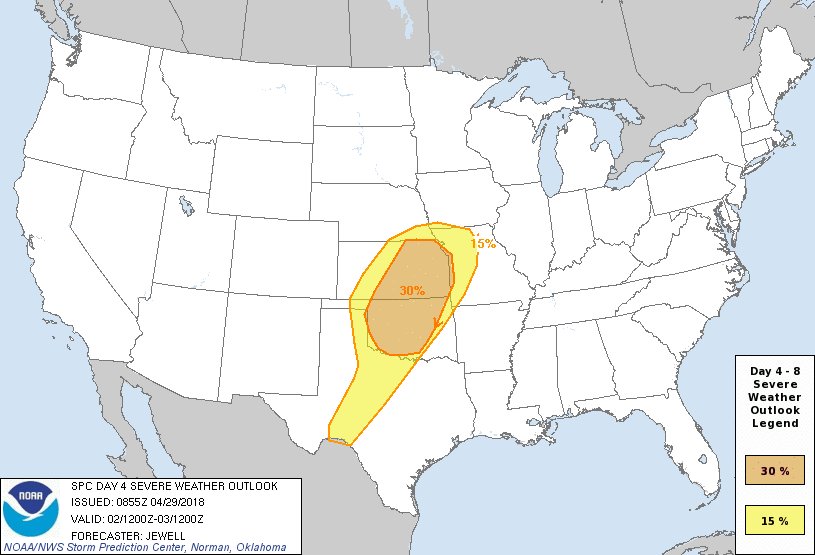
means that a broad area of TX has a chance of showers and
thunderstorms with the climatology for early May suggesting strong to
severe storms possible.

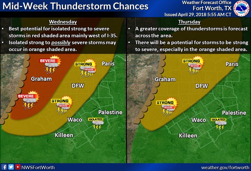
Initially, the dry-line activity should remain dominant with best
rain chances over the southern Edwards Plateau late Wednesday. On
Thursday, a good portion of the mid level dynamics ejects NE into the
Plains and potentially sets up a favorable environment for an MCS
over Central TX. Another piece of energy hangs back and brings a
similar potential over the area late Friday with a cold front adding
to the focus. Should two consecutive MCS type days remain in the
picture for Thursday and Friday, later shifts will need to consider
the potential for locally heavy rainfall.

By Saturday morning, enough of the troughing aloft will have ejected
far enough east to bring a cold front through TX, with rain chances
to continue into late Saturday. Rainfall intenisities should ease off
by daytime Saturday with a more stable pattern developing aloft over
the weakening frontal inversion Sunday morning.
1 likes   
Weather geek and a storm spotter in West Austin. Not a degreed meteorologist. Big snow fan. Love rain and cold! Despise heat!

User avatar
Haris
Category 5
Category 5
Posts: 1810
Joined: Mon Nov 27, 2017 8:19 pm
Location: ( Bee Cave) West Austin, Texas

Re: Texas Spring 2018

#927 Postby Haris » Sun Apr 29, 2018 1:43 pm

Euro
Image

LOCK IT IN
4 likes   
Weather geek and a storm spotter in West Austin. Not a degreed meteorologist. Big snow fan. Love rain and cold! Despise heat!

User avatar
Cpv17
Category 5
Category 5
Posts: 4978
Joined: Wed Dec 07, 2016 2:24 pm
Location: Wharton/El Campo, TX

Re: Texas Spring 2018

#928 Postby Cpv17 » Sun Apr 29, 2018 2:58 pm

Haris wrote:Euro
Image

LOCK IT IN


:uarrow: That would suck for me lol I get 0.1”. High pressure to our east could be too strong for my area to see any significant rains.
0 likes   

User avatar
bubba hotep
S2K Supporter
S2K Supporter
Posts: 5837
Joined: Wed Dec 28, 2016 1:00 am
Location: Collin County Texas

Re: Texas Spring 2018

#929 Postby bubba hotep » Sun Apr 29, 2018 2:59 pm

Image
0 likes   
Winter time post are almost exclusively focused on the DFW area.

weatherdude1108
Category 5
Category 5
Posts: 4228
Joined: Tue Dec 13, 2011 1:04 pm
Location: Northwest Austin/Cedar Park, TX

Re: Texas Spring 2018

#930 Postby weatherdude1108 » Sun Apr 29, 2018 6:55 pm

EWX leaning towards WET. :wink:


000
FXUS64 KEWX 292011
AFDEWX

Area Forecast Discussion
National Weather Service Austin/San Antonio TX
311 PM CDT Sun Apr 29 2018

.SHORT TERM (Tonight through Monday Night)...
Breezy southerly winds continue this evening into the overnight
hours, specially along the Rio Grande Plains. Increased moisture
moving into the area this afternoon will result in more cloud
coverage for the evening period. Latest Doppler radar regional
mosaic images show thunderstorms firing up along a dry-line across
the Pecos area. This feature is expected to move to the east for the
next several hours before it pushes back to the west this evening.
Storms will continue to develop this afternoon and evening ahead of
the dry-line with some of them making forward progression to the
northwest part of the Rio Grande. Most of the Hi-res models bring
convection to the far northwest corner of Val Verde County this
evening with activity coming down to an end before midnight tonight.

This dry-line will be the weather maker for the next few days as it
moves back and forth over west Texas with storms developing ahead of
it. With that said, another line of storms is forecast to develop
Monday evening and once again affect the northwest part of the Rio
Grande. The storm Prediction Center Day 2 categorical outlook
highlights the potential for isolated strong to marginally severe
thunderstorms Monday evening across the far northwest corner of Val
Verde County with main hazard threats being large hail and damaging
gust.

&&

.LONG TERM (Tuesday through Sunday)...
Once again, the dry-line will aid storms to develop across west
Texas while others develop across the Mexican mountains Tuesday
evening into Wednesday. The Rio Grande and southern Edwards Plateau
areas will have the better chances for rain for that period.

The weather pattern becomes interesting and more active on Wednesday
night into Thursday as an upper level disturbance pushes across the
four corners region into the Southern Plains and the dry-line pushes
closer to Val Verde County. Then on Friday, a cold front is forecast
to move down to the northern part of the area and stalls over the
Hill Country.

For the latter part of the forecast package, we could see strong to
severe thunderstorms in addition to episodes of heavy rains. Weather
models keep the area with chances for rain through the weekend. Make
sure you check us out frequently for updates and the latest
information on the wet pattern.
1 likes   
The preceding post is NOT an official forecast, and should not be used as such. It is only the opinion of the poster and may or may not be backed by sound meteorological data. It is NOT endorsed by any professional institution including storm2k.org. For Official Information please refer to the NHC and NWS products.

User avatar
bubba hotep
S2K Supporter
S2K Supporter
Posts: 5837
Joined: Wed Dec 28, 2016 1:00 am
Location: Collin County Texas

Re: Texas Spring 2018

#931 Postby bubba hotep » Sun Apr 29, 2018 7:49 pm

Welcome rain across far West Texas and the Panhandle

Image
4 likes   
Winter time post are almost exclusively focused on the DFW area.

User avatar
bubba hotep
S2K Supporter
S2K Supporter
Posts: 5837
Joined: Wed Dec 28, 2016 1:00 am
Location: Collin County Texas

Re: Texas Spring 2018

#932 Postby bubba hotep » Mon Apr 30, 2018 6:46 am

SPC D3

Image
0 likes   
Winter time post are almost exclusively focused on the DFW area.

User avatar
1900hurricane
Category 5
Category 5
Posts: 6059
Age: 34
Joined: Fri Feb 06, 2015 12:04 pm
Location: Houston, TX
Contact:

Re: Texas Spring 2018

#933 Postby 1900hurricane » Mon Apr 30, 2018 8:13 am

Preliminary thinking is Altus for Wednesday. I've done that and back in a day before, but man that is a long drive.
0 likes   
Contract Meteorologist. TAMU & MSST. Fiercely authentic, one of a kind. We are all given free will, so choose a life meant to be lived. We are the Masters of our own Stories.
Opinions expressed are mine alone.

Follow me on Twitter at @1900hurricane : Read blogs at https://1900hurricane.wordpress.com/

Yukon Cornelius
S2K Supporter
S2K Supporter
Posts: 1798
Age: 41
Joined: Thu Dec 20, 2012 9:23 pm
Location: Dean, TX/Westcliffe, CO

Re: Texas Spring 2018

#934 Postby Yukon Cornelius » Mon Apr 30, 2018 10:46 am

bubba hotep wrote:SPC D3

Image

Looks like some severe weather is finally in store for up this way.
0 likes   
#neversummer

User avatar
cheezyWXguy
Category 5
Category 5
Posts: 6108
Joined: Mon Feb 13, 2006 12:29 am
Location: Dallas, TX

Re: Texas Spring 2018

#935 Postby cheezyWXguy » Mon Apr 30, 2018 12:43 pm

I can see why the slight risk was expanded east to encompass the dfw area on Wednesday. 12z 3knam skew-t’s are pretty interesting in the dfw area at hour 60. Doesn’t show any convection in the area during this time, obviously since forcing is pretty weak until you get out to west tx, but anything that can make its way through the cap should be pretty strong. It should also be noted that the 0z euro shows what are likely supercells moving into the dfw area around 7pm Wednesday.
0 likes   

gpsnowman
S2K Supporter
S2K Supporter
Posts: 3185
Joined: Fri Jan 07, 2011 10:35 am
Location: Grand Prairie Tx

Re: Texas Spring 2018

#936 Postby gpsnowman » Mon Apr 30, 2018 1:32 pm

With much of the month below normal temp wise with pushes of dry air quite frequent, the humidity today is very noticeable. Here it comes folks.
2 likes   

weatherdude1108
Category 5
Category 5
Posts: 4228
Joined: Tue Dec 13, 2011 1:04 pm
Location: Northwest Austin/Cedar Park, TX

Re: Texas Spring 2018

#937 Postby weatherdude1108 » Mon Apr 30, 2018 2:18 pm

The 12Z keeps the highest QPF across central and south central Texas. The GEFS is similar, with more evenly distributed QPF and a tad north in latitude. I would go with a blend of the two, given we RARELY see evenly distributed precipiation.
:P

GFS
Image

GEFS
Image
0 likes   
The preceding post is NOT an official forecast, and should not be used as such. It is only the opinion of the poster and may or may not be backed by sound meteorological data. It is NOT endorsed by any professional institution including storm2k.org. For Official Information please refer to the NHC and NWS products.

User avatar
TheProfessor
Professional-Met
Professional-Met
Posts: 3506
Age: 28
Joined: Tue Dec 03, 2013 10:56 am
Location: Wichita, Kansas

Re: Texas Spring 2018

#938 Postby TheProfessor » Mon Apr 30, 2018 2:31 pm

Question: Does Storm2K have a discord? I just saw that another forum that I don't visit often made one and I thought how cool would it be for there to be a discord server for storm2K
1 likes   
An alumnus of The Ohio State University.

Your local National Weather Service office is your best source for weather information.

User avatar
Haris
Category 5
Category 5
Posts: 1810
Joined: Mon Nov 27, 2017 8:19 pm
Location: ( Bee Cave) West Austin, Texas

Re: Texas Spring 2018

#939 Postby Haris » Mon Apr 30, 2018 2:34 pm

Euro gives Austin around 1.2” .. Gfs at 2” . Still good but the high amounts are gone for this weekend :( . Still fingers crossed.
0 likes   
Weather geek and a storm spotter in West Austin. Not a degreed meteorologist. Big snow fan. Love rain and cold! Despise heat!

User avatar
JDawg512
Category 5
Category 5
Posts: 1076
Age: 45
Joined: Mon Aug 26, 2013 8:56 pm
Location: Austin
Contact:

Re: Texas Spring 2018

#940 Postby JDawg512 » Mon Apr 30, 2018 3:02 pm

At this point, I'll be happy with 1-2 inches. Too much too quickly won't do a ton of good.
1 likes   
Resident Rain Miser

I am a weather hobbyist living 3.5 miles south of Downtown Austin and in no way or fashion should anything I say concerning forecasts be taken seriously. Please check your local NWS for accurate weather forecasting and conditions.


Return to “USA & Caribbean Weather”

Who is online

Users browsing this forum: AnnularCane, Greener and 13 guests