Page 1 of 3
Powerful Winter Storms on US West Coast & North of Hawaii
Posted: Sat Feb 23, 2008 12:17 pm
by Ed Mahmoud
Re: Posilutely frontal, but looks tropical, sort of
Posted: Sat Feb 23, 2008 12:24 pm
by Ed Mahmoud
Snip from NWS MTR AFD (SFO area)
THE CENTER OF THIS MAJOR STORM IS LOCATED 37.7/134.7 WITH A CENTRAL
PRESSURE OF 976 MB ACCORDING TO THE LATEST 15Z HPC SURFACE
ANALYSIS. BUOY 59 AT 38/130 SHOWS WINDS AHEAD OF THE LOW GUSTING TO
50 KTS. SCATTEROMETER WINDS FROM A 1315Z PASS ALSO SHOW WINDS OF 40
TO 50 KTS 250 NMI TO THE WEST OF SAN FRANCISCO. SO WILL SEE A RAMP
UP OF WINDS DURING THE DAY AS WELL AS RAINFALL. HIGHEST WINDS
AGAIN WILL BE ALONG COASTAL AREAS ESPECIALLY NEAR CANYONS AND GAPS
WHERE THE SE WINDS WILL ACCELERATE. ALSO NORTHERN SALINAS VALLEY IS
PRONE TO STRONG WINDS WITH A SE FLOW. PROBABLY WILL NOT SEE THE
STRONGEST WINDS UNTIL THE WARM FRONT PASSES WHICH WILL BE JUST
AFTER 4 PM TO 5 PM TODAY. THIS SHOULD THEN ALLOW GOOD MIXING OF THE
925 MB WINDS DOWN TO NEAR THE SURFACE. SO FROM ALL INDICATIONS
CURRENT WIND WARNING IS ON TRACK AND WILL NOT MODIFY. WILL UPDATE
ZONES TO REFINE TIMING OF RAIN FOR TODAY.
Re: Posilutely frontal, but looks tropical, sort of
Posted: Sat Feb 23, 2008 1:15 pm
by Ed Mahmoud
Hey, this would be a 20 post thread if this thing was North of the Azores now instead of off the Cali coast. ( IN case you know not of what I talk, there was a 2 page thread on an occluded low in the North Atlantic last week).
Yes, it is frontal, but it could bring hurricane force winds to the windier places in California...
Posted: Sat Feb 23, 2008 1:30 pm
by HURAKAN
Posted: Sat Feb 23, 2008 2:43 pm
by RL3AO
Thats impressive. That is also the storm that will bring snow to such snow starved areas as Northern Iowa and Southern Wisconsin.

Re: Posilutely frontal, but looks tropical, sort of
Posted: Sat Feb 23, 2008 3:10 pm
by Sanibel
These back to back systems have been sending rain over the worst drought areas in the Idaho, Utah, Montana areas. And there's one behind it.
The above average California snowpack will get another 2 feet from this one.
Posted: Sat Feb 23, 2008 3:44 pm
by brunota2003
WOW...that is an impressive little system. I know several people from around the San Fran area, so things ought to be interesting.
Posted: Sat Feb 23, 2008 4:45 pm
by HURAKAN

Beautiful system!
Posted: Sat Feb 23, 2008 6:09 pm
by RL3AO
Here is the unnamed unnamed cyclone from the Central Pacific in 2006.

Posted: Sat Feb 23, 2008 8:43 pm
by HURAKAN

Great storm!
Posted: Sat Feb 23, 2008 9:20 pm
by Squarethecircle

If it counts only for the center of the storm, it would look like a hurricane. Nice little eye-ish thing in the middle right there.
Posted: Sat Feb 23, 2008 9:23 pm
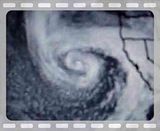
by HURAKAN
Loop:
Posted: Sat Feb 23, 2008 9:30 pm
by Squarethecircle
This is seriously cool for a west-coast non-tropical thing.
Posted: Sat Feb 23, 2008 9:58 pm
by CrazyC83
Kinda has the look and feel of a European windstorm...
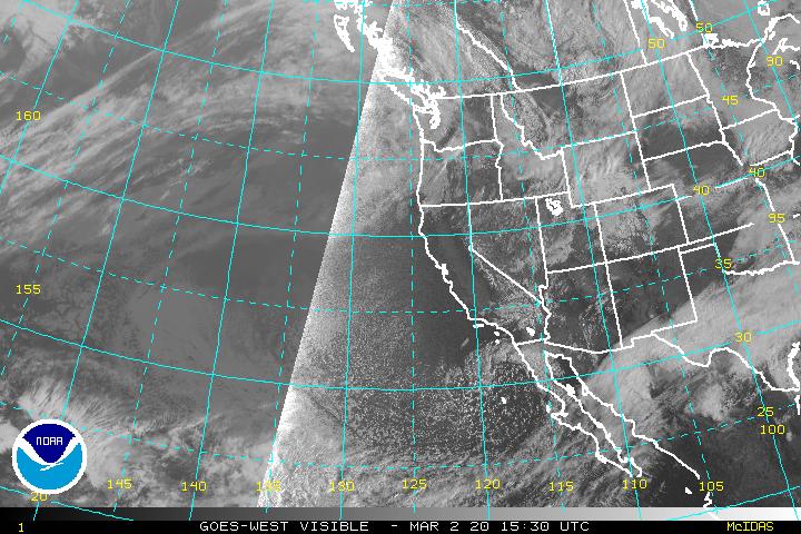
Posted: Sun Feb 24, 2008 8:10 am
by HURAKAN
Posted: Sun Feb 24, 2008 8:17 am
by HURAKAN
Posted: Sun Feb 24, 2008 8:56 am
by HURAKAN
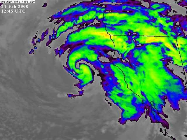
Posted: Sun Feb 24, 2008 10:59 am
by HURAKAN

Beautiful storm!
Posted: Sun Feb 24, 2008 11:02 am
by Squarethecircle
Just to ask, does anyone know the current pressure in the center?
Re:
Posted: Sun Feb 24, 2008 11:25 am
by HURAKAN
Squarethecircle wrote:Just to ask, does anyone know the current pressure in the center?


It's filling up!