Page 1 of 1
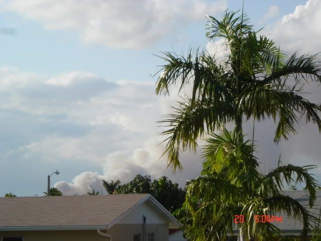
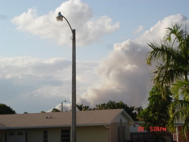
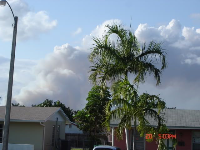
NW Miami Brush Fire (pictures from my home)
Posted: Mon Apr 28, 2008 5:10 pm
by HURAKAN
Metro West Prison Evacuated Due To Brush FirePrisoners Are Being Picked Up By Bus
NW MIAMI DADE (CBS4) ―
Prisoners being held at a county corrections facility are being evacuated due to a large smoky brush fire in Northwest Miami Dade.
Police say prisoners are being loaded onto buses at the Metro West Detention Center and being transferred to another facility as a precaution.
The fire broke out Monday afternoon near Northwest 137th Avenue and Northwest 17th Street; dangerously close to the county's jail facility and Florida's Detention Center and the Reception Center
Forestry officials say the blaze has scorched about 50 acres and is growing rapidly.
Miami-Dade Fire Rescue helicopters are performing water drops to try and bring the flames under control. They are using water from a nearby lake to fill up giant bags with water and then dropping the water on the fire.
No injuries have been reported at this time
_____________________________________

Re: NW Miami Brush Fire (pictures from my home)
Posted: Mon Apr 28, 2008 9:27 pm
by tropicana
great pics as always! Even with 3.57 inches of rain this month in Miami, there hasnt been any significant amounts of rainfall recorded at Miami International Airport ever since Apr 8.... so that tells us the last 20 days have been relatively dry, along with generally warm weather, no doubt thats why brush fires have broken out.
-justin-
Posted: Tue Apr 29, 2008 4:12 pm
by HURAKAN
News Clip:
http://cbs4.com/video/?id=54090@wfor.dayport.comThe brush fire is almost completely out but you can still smell the smoke in the air.
Re: NW Miami Brush Fire (pictures from my home)
Posted: Tue Apr 29, 2008 4:20 pm
by flwxwatcher
The next month or so until the Rainy Season starts will be a nervous time for Florida for wildfires.
Re: NW Miami Brush Fire (pictures from my home)
Posted: Tue Apr 29, 2008 8:34 pm
by MiamiensisWx
This brush fire was visible from the NWS Miami office's sky cam earlier today. If you didn't have knowledge of storm structures and access to the local doppler radar, you might have mistakenly identified the smoke as a tornado, especially if you harbored poorer eyesight.
April is definitely the driest month across the state. This is the heart of the dry season...
Re: NW Miami Brush Fire (pictures from my home)
Posted: Wed Apr 30, 2008 7:54 pm
by tropicana
0.21 inches fell Tuesday night at Miami International Airport, bringing the month's total to 3.78 inches at this site. Many areas of South Florida didn't even get 3 inches this month .
Posted: Wed Apr 30, 2008 7:56 pm
by Cyclone1
Wow, nice pictures Sandy. I've had fires like that VERY close to my house before. The smoke plume was twisting like a tornado, it was awesome. Just a harmless, semi-controlled brush fire, though.
Re: NW Miami Brush Fire (pictures from my home)
Posted: Thu May 01, 2008 4:54 am
by liveweatherman

That was battling the 80-acre fire..Were their injuries on that brush Fire?..
HAZARDOUS WEATHER OUTLOOK
Issue Date: 520 AM EDT THU MAY 01 2008
Expiration: 500 PM EDT THU MAY 01 2008
FLZ063-066>075-168-172>174-012100-
GLADES-HENDRY-INLAND PALM BEACH-METRO PALM BEACH-COASTAL COLLIER-
INLAND COLLIER-INLAND BROWARD-METRO BROWARD-INLAND MIAMI DADE-
METRO MIAMI DADE-MAINLAND MONROE-COASTAL PALM BEACH-
COASTAL BROWARD-COASTAL MIAMI DADE-FAR SOUTH MIAMI DADE-
451 AM EDT THU MAY 1 2008
...DANGEROUS RIP CURRENTS AT ALL ATLANTIC BEACHES...
THIS HAZARDOUS WEATHER OUTLOOK IS FOR SOUTH FLORIDA.
.DAY ONE...TODAY AND TONIGHT
RIP CURRENTS: STRONG EASTERLY WINDS OF 20 MPH ALONG THE ATLANTIC
COAST WILL RESULT IN A HIGH RISK OF DANGEROUS RIP CURRENTS TODAY
AT THE BEACHES OF PALM BEACH, BROWARD AND MIAMI-DADE COUNTIES. THE
STRONGEST RIP CURRENTS WILL TEND TO OCCUR AT THE TIME OF LOW TIDE
WHICH IS BETWEEN 11 AM AND NOON TODAY.
NO OTHER HAZARDOUS WEATHER IS EXPECTED AT THIS TIME.
.DAYS TWO THROUGH SEVEN...FRIDAY THROUGH WEDNESDAY
STRONG AND DANGEROUS RIP CURRENTS WILL CONTINUE ON FRIDAY WITH THE
STRONG EASTERLY FLOW PERSISTING. THE EASTERLY WINDS WILL DECREASE
SOMEWHAT ON SATURDAY BUT THERE WILL STILL BE A RISK OF MODERATE
RIP CURRENTS BEFORE DIMINISHING ON SUNDAY.
NO OTHER HAZARDOUS WEATHER IS EXPECTED AT THIS TIME.
.SPOTTER INFORMATION STATEMENT...
SPOTTER ACTIVATION WILL NOT BE NEEDED.
Posted: Thu May 01, 2008 5:35 am
by HURAKAN
I think the brush fire didn't move towards any neighborhood and no one was injured.