Page 1 of 7
Severe weather Tuesday may 13th...30% hatched area already :
Posted: Sun May 11, 2008 6:12 pm
by 6SpeedTA95
Pretty far in advance to be calling for that type of forcast.
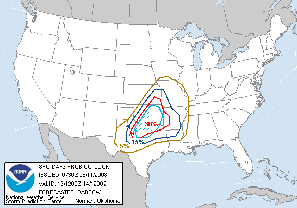
I guess we'll have to look at the day two updates tomorrow to get a better grasp on what exactly we should expect. Things could get interesting on Tuesday. Some of the OKC stations have already issued their own moderate boxes to include the hatched area.
Posted: Sun May 11, 2008 6:24 pm
by CrazyC83
The threat could very well continue into Wednesday and Thursday as well...it is like will we ever get a break?
Re:
Posted: Sun May 11, 2008 7:07 pm
by RL3AO
CrazyC83 wrote:it is like will we ever get a break?
Its the middle of May in one of the busiest seasons recorded and you want a break?

Posted: Sun May 11, 2008 8:09 pm
by Bunkertor
I think i´ll need a break - and maybe folks in MO and AR.
Re: Severe weather Tuesday may 13th...30% hatched area already :
Posted: Sun May 11, 2008 8:47 pm
by Ed Mahmoud
Utah U web site hasn't updated the GFS or WRF models since April 30th, so no posting images, but AccuWeather PPV site 18Z WRF shows rain breaking out before 4 pm CDT Tuesday afternoon in North Central Texas, with 50 to 70 knots shear in the area, and in excess of 2000 Joules/Kg CAPE, with a narrow area near Wichita Falls over 3500 Joules/Kg.
Storm relative helcities 100 to 150 J/Kg at 4 pm, increasing to in excess of 150 J/Kg.
Surface winds of 10 to 15 knots limit the helicity a tad. Ditto 20 to 30 knot 850 mb winds, which would suggest more of a large hail threat than a tornado threat, but I've read enough SPC and local NWS discussions to know that helicity may be enhanced near boundaries and boundary intersections, and high CAPE and strong deep shear might still be a recipe for trouble.
0Z WRF starting to come in.
older 12Z GFS had a similar depiction, storms in the area, strong mid level winds and instability, relatively weak low level winds.

Re: Severe weather Tuesday may 13th...30% hatched area already :
Posted: Mon May 12, 2008 2:48 am
by zaqxsw75050
Posted: Mon May 12, 2008 6:01 am
by Extremeweatherguy
The 30% hatched area now extends into Wednesday as well...

Re: Re:
Posted: Mon May 12, 2008 8:15 am
by CrazyC83
RL3AO wrote:CrazyC83 wrote:it is like will we ever get a break?
Its the middle of May in one of the busiest seasons recorded and you want a break?
Could 2008 be to tornadoes what 2005 was to hurricanes?
Re: Re:
Posted: Mon May 12, 2008 8:46 am
by snoopj
CrazyC83 wrote:RL3AO wrote:CrazyC83 wrote:it is like will we ever get a break?
Its the middle of May in one of the busiest seasons recorded and you want a break?
Could 2008 be to tornadoes what 2005 was to hurricanes?
That's a scary, scary thought.
I feel bad for that southern Missouri/Northern Arkansas corridor that seems to be slammed right now. The worst part is that the patterns will start shifting north as the season wears on. Will we see the KC Severe Weather Express? Who knows, but given the track record, it could happen.
Never fails. Buy a new house, get slammed with something. I've already missed one tornado by 3/4-mile. A quick hitting EF3 at that.
--snoopj
Re: Re:
Posted: Mon May 12, 2008 8:50 am
by CrazyC83
snoopj wrote:CrazyC83 wrote:
Could 2008 be to tornadoes what 2005 was to hurricanes?
That's a scary, scary thought.
I feel bad for that southern Missouri/Northern Arkansas corridor that seems to be slammed right now. The worst part is that the patterns will start shifting north as the season wears on. Will we see the KC Severe Weather Express? Who knows, but given the track record, it could happen.
Never fails. Buy a new house, get slammed with something. I've already missed one tornado by 3/4-mile. A quick hitting EF3 at that.
--snoopj
At this rate, come June, the northern Plains and Great Lakes from the Dakotas to New England are sure to be slammed constantly...
Re: Severe weather Tuesday may 13th...30% hatched area already :
Posted: Mon May 12, 2008 9:53 am
by Ed Mahmoud
New WRF starting to come in, with first shot of rain East Texas, Oklahoma and West Arkansas by early evening, and a new shot of rain in Northwest/North Central Texas by late evening.
WRF forecast soundings show generally under 1000 J/Kg CAPE for East Texas/Arkansas early evening activity.
Relatively light lower level winds, instability about 2500 J/Kg in North Central Texas in early evening, when storms arrive (per WRF) late evening loss of daytime heating has dropped CAPE to about 1500 J/Kg.
The WRF shows a fair amount of rain tomorrow in places, but doesn't have rain, instability and goo low level shear together all in one place, so at least per the WRF, tomorrow shouldn't be a high level severe event in Texas/Oklahoma/Louisiana/Arkansas.
Re: Severe weather Tuesday may 13th...30% hatched area already :
Posted: Mon May 12, 2008 10:04 am
by Ed Mahmoud
One thing in favor for later evening severe in DFW tomorrow, despite modest low level winds and CAPE down to about 1500 J/Kg as storms arrive due diurnal cooling, deep layer shear is between 50 and 80 knots, and while storms could be elevated above the cap, there is very strong speed shear in the area of greatest instability, so hail may be in the offing.
If the WRF is correct.

Posted: Mon May 12, 2008 10:45 am
by RL3AO
Lets see if they go MDT at 1730z.
Re: Re:
Posted: Mon May 12, 2008 10:49 am
by RL3AO
CrazyC83 wrote:RL3AO wrote:CrazyC83 wrote:it is like will we ever get a break?
Its the middle of May in one of the busiest seasons recorded and you want a break?
Could 2008 be to tornadoes what 2005 was to hurricanes?
2004 had 1819 confirmed tornadoes. Will 2008 get there? Might depend on the hurricane season. Ivan and Frances caused 222 tornadoes. Personally I think we will get to about 1600, but its just a guess.
Re: Re:
Posted: Mon May 12, 2008 10:53 am
by CrazyC83
RL3AO wrote:
2004 had 1819 confirmed tornadoes. Will 2008 get there? Might depend on the hurricane season. Ivan and Frances caused 222 tornadoes. Personally I think we will get to about 1600, but its just a guess.
The difference is that a larger percentage in 2004 were fairly weak (as normal from tropical outbreaks) - we are way ahead of that year for strong/violent tornadoes and (especially) killer tornadoes.
Re: Severe weather Tuesday may 13th...30% hatched area already :
Posted: Mon May 12, 2008 12:18 pm
by Ed Mahmoud
1730 SWODY2 out a bit early.Kansas City to near DFW in a hatched and greater than 30% risk area, with talk of an upgrade of Kansas and Oklahoma sections to
MODERATE RISK on the early morning SWODY1
Re: Severe weather Tuesday may 13th...30% hatched area already :
Posted: Mon May 12, 2008 4:03 pm
by Ed Mahmoud
TOP and EAX doubt sufficient moisture return, plus low clouds much of the day, will allow enough destabilization for widespread severe.
However, SGF, further South, anticipates enough instability for an active severe pm tomorrow
MEANWHILE THE AIRMASS WILL DESTABILIZE FARTHER WEST ACROSS EASTERN
KANSAS AND FAR SOUTHWEST MISSOURI. SOME QUESTION REMAINS ON THE
EXTENT OF LOW LEVEL MOISTURE ADVECTION BUT SURFACE DEWPOINTS IN
THE MIDDLE 60S SEEM REASONABLE ALONG THE KANSAS MISSOURI BORDER BY
MID AFTERNOON. ALSO SHEAR PARAMETERS WILL BECOME MORE FAVORABLE AS
A STRONG MID AND UPPER LEVEL JET STREAK INTO THE SOUTHERN PLAINS.
EXISTING CAPPING INVERSION SHOULD BREAK MID TO LATE AFTERNOON WITH
THE INFLUENCE OF THE UPPER JET AND LOW LEVEL MASS CONVERGENCE
ALONG THE SURFACE COLD FRONT. PROGGED SOUNDINGS INDICATE THAT
CELLS WILL QUICKLY BECOME SUPER CELLS OVER SOUTHEAST KANSAS LATE
TUESDAY AFTERNOON. LACK OF DEFINED SURFACE LOW MAY INHIBIT
PRONOUNCED LOW LEVEL BACKING OF THE WINDS BUT LOW LEVEL HELICITIES
WILL STILL BE SUFFICIENT FOR TORNADIC DEVELOPMENT. ANY INCREASE IN
SURFACE DEWPOINTS AND LOW LEVEL WIND SHEAR WOULD INCREASE THE RISK
FOR TORNADOES. SOUNDINGS ALSO SUPPORTIVE OF LARGE HAIL AND
DAMAGING WINDS. THE RISK OF SEVERE WEATHER WILL BE GREATEST WEST
OF HIGHWAY 65 FROM LATE AFTERNOON INTO THE EVENING. THE STORMS
WILL LIKELY TRANSITION TO A SQUALL LINE OR LINE SEGMENTS DURING THE
NIGHT AND GRADUALLY WEAKEN.
Norman, being further South, are confident of sufficient instability for severe:
SOUTH WINDS AND DEVELOPING LLJ WILL BRING LOW LEVEL MOISTURE
NORTHWARD QUICKLY OVERNIGHT INTO EARLY TUE AHEAD OF STORM SYSTEM
TAKING SHAPE TO OUR WEST. SHOULD SEE STRATUS OVERSPREAD MUCH OF THE
AREA AFTER MIDNIGHT. SFC COLD FRONT WILL ENTER NORTHWEST OKLAHOMA
EARLY TUE MORNING AS AREA OF SFC LOW PRES DROPS SE OUT OF SE
COLORADO. MUCH OF THE DAY SHOULD REMAIN QUIET AS WARM LAYER ABOVE
THE GROUND WILL KEEP CONVECTION AT BAY. HOWEVER BY LATE AFTN AS LIFT
DEVELOPS ALONG SFC BOUNDARIES... CAP SHOULD ERODE SUFFICIENTLY FOR
SCATTERED TSTMS ALONG COLD FRONT AND DRYLINE ACROSS CENTRAL SECTIONS
OF OKLAHOMA... EVEN WITH MAIN UPPER LOW WELL WEST OF AREA. IF MODELS
ARE CLOSE WITH RETURN MOISTURE AND GETTING UPPER 60 DEWPOINTS INTO
AREA AHEAD OF FRONT... SFC CAPES APPROACHING 4000 J/KG WILL BE
AVAILABLE IN WARM SECTOR WITH VERY LITTLE CIN BY 21Z. SEVERE STORMS ARE
ANTICIPATED BY LATE AFTN INTO THE EVENING HOURS.
FWD
MOISTURE RETURN COMMENCING THIS AFTERNOON AND 60 DEWPOINTS
EXPECTED BACK INTO NORTH TEXAS BY MORNING...ALONG WITH THE USUAL
STRATUS. UPPER WAVE MOVES OVER COASTAL TEXAS AND HAVE INDICATED
CHANCE POPS IN THE SOUTH AND SOUTHEAST TUESDAY...THE NORTHERN END
OF THIS SYSTEM. NEW FRONT MOVES INTO NW ZONES AND STALLS TUESDAY
EVENING AND I HAVE DRAMATICALLY INCREASED POPS BEGINNING TUESDAY
NIGHT...WITH LIKELY POPS OVER ALL NORTH TEXAS WEDNESDAY MORNING.
SEVERE WEATHER PARAMETERS INDICATE LARGE HAIL AND DAMAGING WINDS
AS THE PRIMARY THREATS.
Posted: Mon May 12, 2008 8:47 pm
by wx247
I want a break.

Posted: Mon May 12, 2008 8:51 pm
by 6SpeedTA95
Right now they're saying a wide swath (basically the main body of the state) of Oklahoma will have dewpoints in the mid/upper 60s tomorrow with temperatures in the upper 70s to mid 80s. Cape values will range from 3000 to 4500 J/kg with LI's of -8 to -10. Thats substantial and each passing model run has so far increased the likely hood of a severe weather outbreak tomorrow. New runs come in late this evening and early tomorrow morning.
Posted: Mon May 12, 2008 9:01 pm
by 6SpeedTA95
The dewpoint is beginning to steadily rise here with a moderate south wind. We've gone from 42* at 6pm to 45* at 9pm
