Page 1 of 3
996MB Gale Center to bomb off Eastern Seaboard
Posted: Sat Jun 20, 2009 8:07 pm
by TropicalWXMA
GFS Day 3 - 66 hours out:

Buoy 44018 30 miles east of Cape Cod:

Posted: Sat Jun 20, 2009 8:09 pm
by TropicalWXMA
Buoy 44011 170 miles east of Hyannis, MA.

Posted: Sat Jun 20, 2009 8:11 pm
by TropicalWXMA
Re: 996MB Gale Center to bomb off Eastern Seaboard
Posted: Sat Jun 20, 2009 8:21 pm
by TropicalWXMA
Current Marine Advisories/Statements:
COASTAL HAZARD MESSAGE
NATIONAL WEATHER SERVICE GRAY ME
157 PM EDT SAT JUN 20 2009
...SEVERAL SPLASH-OVER OR MINOR COASTAL FLOOD EVENTS ARE POSSIBLE
OVER THE NEXT FEW DAYS...
.LOW PRESSURE WILL ORGANIZE SOUTHEAST OF LONG ISLAND NEW YORK ON
SUNDAY. THIS ANOMOLOUS COASTAL SYSTEM WILL REMAIN NEARLY
STATIONARY EARLY NEXT WEEK AS HIGH PRESSURE STAYS SITUATED OVER
THE CANADIAN MARITIMES. THE TWO WEATHER SYSTEMS WILL CREATE A LONG
DURATION OF NORTHEAST WINDS AND MODERATELY BUILDING WAVES OVER THE
NEW ENGLAND COASTAL WATERS.
THE NORTHEAST WINDS AND BUILDING WAVES MAY COMBINE WITH THE
HIGHEST ASTRONOMICAL TIDES OF THE MONTH TO PRODUCE SPLASH-OVER
DURING SOME OF OUR HIGH TIDES THROUGH EARLY NEXT WEEK. IN
ADDITION...STORM TIDES A HALF FOOT TO A FOOT IN MAGNITUDE WILL PRODUCE
STORM TIDES NEAR OR ABOVE THE 12 FOOT FLOOD BENCHMARK IN PORTLAND
HARBOR. THIS WOULD CAUSE PERIODS OF MINOR COASTAL FLOODING. EAST
OR NORTHEAST FACING BEACHES ALONG COASTAL CUMBERLAND...YORK AND
ROCKINGHAM COUNTIES WILL HAVE THE GREATEST RISK FOR SPLASH-OVER OR
COASTAL FLOODING.
ALSO...THE MOST VULNERABLE STORM TIDE APPEARS TO BE THE 1026 PM
SUNDAY NIGHT HIGH TIDE WHEN SPLASH-OVER AND BEACH EROSION IS
POSSIBLE. OTHER STORM TIDES TO WATCH FOR BOTH SPLASH-OVER AND
COASTAL FLOODING WILL BE 1120 PM MONDAY NIGHT AND 1215 AM
WEDNESDAY MORNING. THESE TIDES MAY BE SIMILAR TO THE MAY...2005
COASTAL EVENTS.
SPLASH-OVER IS DEFINED AS BEACH EROSION OR STRUCTURAL DAMAGE DUE TO
THE COMBINED PRESENCE OF BUILDING WAVES AND STORM TIDES ALONG
BEACH PROPERTIES. COASTAL INUNDATION IS THE SUBMERSION OF WATER
AROUND LOW LEVEL PROPERTIES AND ESTUARIES DUE TO HIGH WATER
LEVELS.
Also, Gale Warning up from Sunday afternoon through Monday morning for coastal waters from the Merrimack River, MA to Watch Hill, RI out to 25 NM.
Re: 996MB Gale Center to bomb off Eastern Seaboard
Posted: Sat Jun 20, 2009 9:05 pm
by TropicalWXMA
Latest AFD from KBOX is pretty much exclusively about the gale low:
http://forecast.weather.gov/product.php ... roduct=AFDif other people want to chime in, please by all means feel free too!
Re: 996MB Gale Center to bomb off Eastern Seaboard
Posted: Sat Jun 20, 2009 9:14 pm
by TropicalWXMA
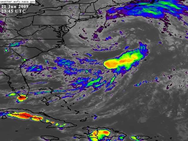
Starting to get it's act together:

Posted: Sun Jun 21, 2009 12:19 am
by TropicalWXMA
http://www.ssec.wisc.edu/data/east/anim ... astwv.htmlMain LLC is still over SE NY. Some offshore convective flaring taking place away from the center.
More in the morning.
Posted: Sun Jun 21, 2009 1:07 am
by brunota2003
For those who do not know (I had to look it up myself), 29.50" is also 999 millibars. (Reference buoy charts above)
Re: 996MB Gale Center to bomb off Eastern Seaboard
Posted: Sun Jun 21, 2009 3:50 am
by HurricaneBill
Late season nor'easter?
Posted: Sun Jun 21, 2009 11:55 am
by brunota2003
29.41" is 996 millibars!
Re: 996MB Gale Center to bomb off Eastern Seaboard
Posted: Sun Jun 21, 2009 12:19 pm
by TropicalWXMA
this thing is starting to BOMB!
http://www.ssec.wisc.edu/data/east/anim ... astwv.htmlBTW, coastal flood statement extended south into eastern mass.
Posted: Sun Jun 21, 2009 2:25 pm
by brunota2003
29.38 is 995 millibars
29.35 is 994 millibars
The buoy thus far has reached 29.38, so it is one millibar stronger (thus far) than predicted.
Re: 996MB Gale Center to bomb off Eastern Seaboard
Posted: Sun Jun 21, 2009 5:38 pm
by Persepone
29.38 at 6:25 p.m. in Marstons Mills, MA
Re: 996MB Gale Center to bomb off Eastern Seaboard
Posted: Sun Jun 21, 2009 6:29 pm
by cpdaman
not sure if this is a double barrell system (lined up N-S) or just elongated ......pretty sure the lower part or (low pressure east of delmarva) is getting into the gulf stream waters ......which begins around 37.5 or so ....
http://metofis.rsmas.miami.edu/~dortt/s ... 1_loop.gifgood chart from navy site as of 6-19
https://oceanography.navy.mil/legacy/we ... index.html
Posted: Sun Jun 21, 2009 6:43 pm
by DanKellFla
Is this system going to cause some crazy weather in South Florida on Monday?
Re: 996MB Gale Center to bomb off Eastern Seaboard
Posted: Sun Jun 21, 2009 8:19 pm
by TropicalWXMA
Buoy #44011 at 41.111N 66.58W (170 NM East of Hyannis, MA) is registering an atmospheric pressure reading at 29.35 inches, which converts to 993 Millibars.
By the way, the outflow from this storm is reaching just south of Cuba and is causing a few diurnal thunderstorms over Cuba.
Re: 996MB Gale Center to bomb off Eastern Seaboard
Posted: Sun Jun 21, 2009 8:28 pm
by TropicalWXMA
CMC:

GFS (Note heavy QPF over eastern/coastal Mass.):
 Gale, Coastal Flood, and High Surf Advisories/Warnings up all along the coasts of Mass., NH, and ME.
Expecting 15 foot waves to arrive in the outer coastal waters by Monday morning.
Re: 996MB Gale Center to bomb off Eastern Seaboard
Posted: Sun Jun 21, 2009 8:33 pm
by TropicalWXMA
Also a LOT of upwelling is forecasted with this storm, which will ironically help weaken it by Tuesday as it exits into the Canadian Maritimes.
Keep an eye on the Gulf Stream SST maps and you'll start to see the cooler waters under the storm showing!
Posted: Sun Jun 21, 2009 8:40 pm
by HURAKAN
Posted: Sun Jun 21, 2009 8:45 pm
by TropicalWXMA

