Larger Moderate Risk area at latest update.
Day 2 Convective Outlook
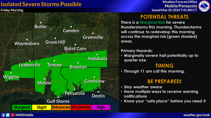
NWS Storm Prediction Center Norman OK
1230 PM CDT Tue Apr 04 2017
Valid 051200Z - 061200Z
...THERE IS A MODERATE RISK OF SEVERE THUNDERSTORMS ACROSS PARTS OF
AL/GA/SC AND THE FL PANHANDLE... ...THERE IS AN ENHANCED RISK OF SEVERE THUNDERSTORMS ACROSS PARTS OF
THE OH/TN VALLEYS TO THE SOUTHEAST...
...THERE IS A SLIGHT RISK OF SEVERE THUNDERSTORMS FROM THE OH VALLEY
TO THE SOUTHEAST AND MID-ATLANTIC...
...THERE IS A MARGINAL RISK OF SEVERE THUNDERSTORMS SURROUNDING THE
SLIGHT RISK...
...SUMMARY...
An outbreak of severe thunderstorms is likely Wednesday across much
of the Southeast, continuing northward along and west of the
Appalachians into the Tennessee and Ohio Valleys. This will include
supercell development with a risk for tornadoes, some of which will
be strong and long-lived, particularly across the Southeast. Large
to very large hail and damaging straight-line winds also appear
likely.
...Synopsis...
A highly amplified mid/upper-level trough will be present across the
Plains at the beginning of the period, moving eastward to the MS
Valley by Wednesday evening, and continuing to the OH/TN Valleys and
Southeast by early Thursday morning. Two 100+ kt upper-level jets
will be present across areas of severe potential Wednesday, one
associated with the eastward-moving trough over LA/MS/AL/TN, and
another 90-100+ kt sub-tropical jet nosing over southeastern AL, the
FL Panhandle, and GA through Wednesday evening. Strong 50-80+ kt
mid-level southwesterly winds will overspread much of the OH/TN
Valleys and Southeast through the peak of the diurnal heating cycle,
and these winds will then overspread much of the East Coast
Wednesday evening through the end of the period.
A strong southwesterly low-level jet is expected to advect rich Gulf
moisture northward across portions of MS/AL/GA by Wednesday morning.
This jet will shift eastward across GA/SC/NC/VA through the
afternoon and early evening before strengthening further late
Wednesday into early Thursday morning across the Mid-Atlantic. A
somewhat separate corridor of strong southerly/southwesterly
low-level winds will be associated with the mid/upper-level trough,
and will overspread much of the OH/TN Valleys through the period. At
the surface, an area of low pressure initially over southeastern MO
will develop northeastward to IL/IN by Wednesday evening while
deepening. This low will then slowly continue northeastward to the
vicinity of the eastern Great Lakes by the end of the period. An
attendant cold front will move eastward across the OH/TN Valleys and
Southeast Wednesday, reaching the Mid-Atlantic by the end of the
period.
...Southeast into the Mid-Atlantic...
Warm air advection/LLJ related convection should form along the
northward-moving warm front early Wednesday morning across parts of
eastern MS, AL, and perhaps GA. This initial activity will pose a
threat for all severe hazards, including tornadoes along/south of
the front where surface-based convection will be more likely.
Additional supercell development appears likely within the broad
warm sector across the central Gulf Coast States, particularly
across AL into GA/SC Wednesday morning/afternoon as large-scale
ascent associated with the upper trough begins to overspread the
Southeast. Forecast soundings across this region suggest strong
tornadoes will be possible with any discrete storm that can form in
this environment, in addition to very large hail and damaging
straight-line winds. Severe probabilities have been
increased/expanded westward slightly in western AL/eastern MS with
latest model guidance showing convective development both Wednesday
morning and another round associated with the large-scale forcing
for ascent with the upper trough Wednesday afternoon ahead of the
cold front.
As the convection that develops Wednesday morning/afternoon moves
across the Carolinas in the evening, a nocturnal increase in
instability and resulting severe potential are possible across parts
of the Carolinas into southeastern VA. This would occur in tandem
with increasing low-level winds associated with a previously
mentioned low-level jet, and strengthening mid/upper-level winds
attendant to the approaching upper trough. If convection can become
surface based in this region, then all severe hazards may occur,
including a threat for tornadoes. Have accordingly
expanded/increased severe probabilities across the Carolinas and
southern/southeastern VA to account for this threat late Wednesday
night into early Thursday morning.
...OH/TN Valleys...
The northward advance of low-level moisture will be more limited
across the OH/TN Valleys Wednesday, but will still be more than
sufficient to support surface-based convection. A band of supercells
appear likely per latest model guidance given the strength of low
and mid-level winds coupled with weak to locally moderate
instability. Large to very large hail and damaging winds appear to
be the main threats, with a few tornadoes also possible. Given the
forecast coverage of convection, it is not out of the question that
higher severe probabilities may need to be considered in a later
outlook update.
..Gleason.. 04/04/2017

