Texas Summer 2018
Moderator: S2k Moderators
Forum rules

The posts in this forum are NOT official forecast and should not be used as such. They are just the opinion of the poster and may or may not be backed by sound meteorological data. They are NOT endorsed by any professional institution or STORM2K.
-
weatherdude1108
- Category 5

- Posts: 4172
- Joined: Tue Dec 13, 2011 1:04 pm
- Location: Northwest Austin/Cedar Park, TX
Re: Texas Summer 2018
I like the trend, especially the ECMWF.
My house has not reached 100 since last week, much less 103. So my streak already broke.
Camp Mabry tends to be hotter than everybody else 95 percent of the time, and it's next to MOPAC. Anyway, could be some influences there with nearby asphalt and concrete IMO.
ECMWF

GFS

Extended

My house has not reached 100 since last week, much less 103. So my streak already broke.
Camp Mabry tends to be hotter than everybody else 95 percent of the time, and it's next to MOPAC. Anyway, could be some influences there with nearby asphalt and concrete IMO.
ECMWF
GFS
Extended
1 likes
The preceding post is NOT an official forecast, and should not be used as such. It is only the opinion of the poster and may or may not be backed by sound meteorological data. It is NOT endorsed by any professional institution including storm2k.org. For Official Information please refer to the NHC and NWS products.
-
Haris

- Category 5
- Posts: 1808
- Joined: Mon Nov 27, 2017 8:19 pm
- Location: ( Bee Cave) West Austin, Texas
Re: Texas Summer 2018
If the EPS verify , our last 100s of the season are this weekend in Austin. 90-91 beyond that thru mid sep
2 likes
Weather geek and a storm spotter in West Austin. Not a degreed meteorologist. Big snow fan. Love rain and cold! Despise heat!
-
weatherdude1108
- Category 5
- Posts: 4172
- Joined: Tue Dec 13, 2011 1:04 pm
- Location: Northwest Austin/Cedar Park, TX
Re: Texas Summer 2018
Haris wrote:If the EPS verify , our last 100s of the season are this weekend in Austin. 90-91 beyond that thru mid sep
Good riddance!
2 likes
The preceding post is NOT an official forecast, and should not be used as such. It is only the opinion of the poster and may or may not be backed by sound meteorological data. It is NOT endorsed by any professional institution including storm2k.org. For Official Information please refer to the NHC and NWS products.
-
South Texas Storms

- Professional-Met

- Posts: 4018
- Joined: Thu Jun 24, 2010 12:28 am
- Location: Houston, TX
Re: Texas Summer 2018
weatherdude1108 wrote:Haris wrote:If the EPS verify , our last 100s of the season are this weekend in Austin. 90-91 beyond that thru mid sep
Good riddance!
Yeah don't let the door hit ya on the way out.
2 likes
-
CaptinCrunch

- S2K Supporter

- Posts: 8579
- Age: 56
- Joined: Mon Nov 03, 2003 4:33 pm
- Location: Lake Worth, TX (Tarrant Co.)
Re: Texas Summer 2018
81% of the State seeing some sort of drought condictions......we need some serious rains this Fall and Winter!

1 likes
-
bubba hotep

- S2K Supporter
- Posts: 5527
- Joined: Wed Dec 28, 2016 1:00 am
- Location: Collin County Texas
Re: Texas Summer 2018
Got to love the 12z GFS, keeps the wave moving across the Gulf weak and pumps a steady stream of moisture into Texas.

3 likes
Winter time post are almost exclusively focused on the DFW area.
-
Brent
- S2K Supporter
- Posts: 37124
- Age: 35
- Joined: Sun May 16, 2004 10:30 pm
- Location: Tulsa Oklahoma
- Contact:
Re: Texas Summer 2018
Euro looks pretty active too and keeps the Gulf thing also weak
2 likes
#neversummer
-
weatherdude1108
- Category 5
- Posts: 4172
- Joined: Tue Dec 13, 2011 1:04 pm
- Location: Northwest Austin/Cedar Park, TX
Re: Texas Summer 2018
Brent wrote:Euro looks pretty active too and keeps the Gulf thing also weak
Weak is better. It keeps the moisture going, instead of getting sucked up by a strong hurricane, leaving the outskirts around it bone dry.
3 likes
The preceding post is NOT an official forecast, and should not be used as such. It is only the opinion of the poster and may or may not be backed by sound meteorological data. It is NOT endorsed by any professional institution including storm2k.org. For Official Information please refer to the NHC and NWS products.
Re: Texas Summer 2018
weatherdude1108 wrote:Brent wrote:Euro looks pretty active too and keeps the Gulf thing also weak
Weak is better. It keeps the moisture going, instead of getting sucked up by a strong hurricane, leaving the outskirts around it bone dry.
True. The only thing Harvey brought North Texas was clouds and slightly cooler air.
1 likes
-
Brent
- S2K Supporter
- Posts: 37124
- Age: 35
- Joined: Sun May 16, 2004 10:30 pm
- Location: Tulsa Oklahoma
- Contact:
Re: Texas Summer 2018
gpsnowman wrote:weatherdude1108 wrote:Brent wrote:Euro looks pretty active too and keeps the Gulf thing also weak
Weak is better. It keeps the moisture going, instead of getting sucked up by a strong hurricane, leaving the outskirts around it bone dry.
True. The only thing Harvey brought North Texas was clouds and slightly cooler air.
and then a heat wave after... no thanks
1 likes
#neversummer
-
weatherdude1108
- Category 5
- Posts: 4172
- Joined: Tue Dec 13, 2011 1:04 pm
- Location: Northwest Austin/Cedar Park, TX
Re: Texas Summer 2018
Brent wrote:gpsnowman wrote:weatherdude1108 wrote:
Weak is better. It keeps the moisture going, instead of getting sucked up by a strong hurricane, leaving the outskirts around it bone dry.
True. The only thing Harvey brought North Texas was clouds and slightly cooler air.
and then a heat wave after... no thanks
Yeah, it usually leaves central and south Texas hot and dry (if it heads towards Beaumont or points east). But as far as now, I'm seeing a wetter pattern shift on the horizon.
1 likes
The preceding post is NOT an official forecast, and should not be used as such. It is only the opinion of the poster and may or may not be backed by sound meteorological data. It is NOT endorsed by any professional institution including storm2k.org. For Official Information please refer to the NHC and NWS products.
-
weatherdude1108
- Category 5
- Posts: 4172
- Joined: Tue Dec 13, 2011 1:04 pm
- Location: Northwest Austin/Cedar Park, TX
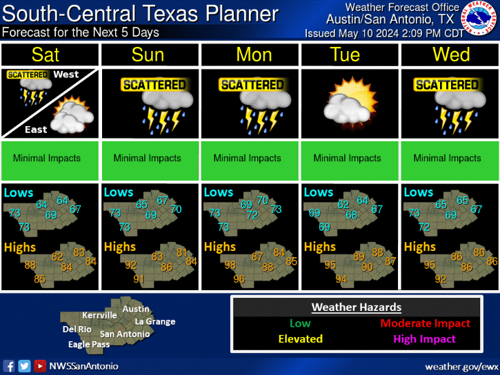
Re: Texas Summer 2018
000
FXUS64 KEWX 302010
AFDEWX
Area Forecast Discussion
National Weather Service Austin/San Antonio TX
310 PM CDT Thu Aug 30 2018
.SHORT TERM (Tonight through Friday Night)...
Afternoon temperatures across most of the region are running roughly
1-3 degrees cooler when compared to yesterday`s readings. A slight
uptick in moisture and cloud cover along with some weakening of the
subtropical high is likely the reason for the temperature change.
However, we should still see afternoon highs peak at or just above
climatological normals today. Otherwise, some showers are noted
across the coastal plains, mainly south of a Hallettsville to Karnes
City line.
The above mentioned showers should mostly remain confined to the
coastal plains through this afternoon, although some showers could
drift westward to a Giddings to Floresville line. This activity is
drive by diurnal heating and we expect most of the showers and storms
to dissipate with the loss of daytime heating. We expect a very
similar pattern tomorrow with high temperatures in the 90s and some
afternoon convection mainly confined to the coastal plains.
&&
.LONG TERM (Saturday through Thursday)...
The weather pattern begins to change slightly for the upcoming
weekend as an upper trough axis begins to slowly move into the
southern Rockies. This will help displace the subtropical ridge axis
eastward into the southeastern U.S. With less of an influence from
the subtropical ridge axis and a gradual increase in deep layer
moisture, we can expect isolated to scattered showers and
thunderstorms mainly in the afternoon and early evening hours for
most of the Hill Country and along and east of I-35. We will also
keep a low chance for convection across Val Verde county on Sunday to
account for any activity that develops over the higher terrain of
Mexico.
For the early and middle portion of the upcoming work week, the
subtropical ridge axis over the southeastern U.S. strengthens and
expands, while the upper trough deepens over the Pacific Northwest.
This should keep a fairly deep and moist southeasterly flow across
south central Texas. With this pattern intact, it appears our
temperatures should remain at or just below climatological normals
Monday through Thursday. We can also expect isolated to scattered
showers and thunderstorms across most of the region given deep layer
moisture and diurnal heating. For now, we will keep rain chances
fairly low, but may need to increase pending later model runs.
0 likes
The preceding post is NOT an official forecast, and should not be used as such. It is only the opinion of the poster and may or may not be backed by sound meteorological data. It is NOT endorsed by any professional institution including storm2k.org. For Official Information please refer to the NHC and NWS products.

Re: Texas Summer 2018
Today is the last day to post in this thread. I will open the Fall thread at midnight marking the end of 2018 meteorological Summer and begin meteorological Fall.
2 likes
The above post and any post by Ntxw is NOT an official forecast and should not be used as such. It is just the opinion of the poster and may or may not be backed by sound meteorological data. It is NOT endorsed by any professional institution including Storm2k. For official information, please refer to NWS products.
Help support Storm2K!
-
Yukon Cornelius
- S2K Supporter
- Posts: 1738
- Age: 40
- Joined: Thu Dec 20, 2012 9:23 pm
- Location: Dean, TX/Westcliffe, CO
Re: Texas Summer 2018
I don't know if this has been discussed yet or not but is there any correlation between all of the hurricanes and storms in the Pacific this year and the possible developing El Nino?
0 likes
#neversummer
Re: Texas Summer 2018
Yukon Cornelius wrote:I don't know if this has been discussed yet or not but is there any correlation between all of the hurricanes and storms in the Pacific this year and the possible developing El Nino?
There is a strong correlation between Pacific (both West Pacific and East Pacific) and El Nino. Not only that, El Nino tends to promote more intense Hurricanes/Typhoons in larger numbers due to warming the Pacific Ocean and decreased wind shear. 2015 is a prime example of being the second busiest EPAC season, creating one of the wettest Falls on record amid a Super El Nino. You could probably name significantly wet Falls and 9/10 it will probably be due to an active EPAC and an El Nino.
As for Texas the East Pacific hurricane season correlates to rainfall patterns in the Fall. During El Nino, there is an increase of systems that gets caught up and re-curves into Western Mexico and subsequently sends moisture towards Texas. Part of the reason why October is often the second wettest month for many in the state is aided by this phenomenon.
During La Nina the opposite tends to occur. Pacific hurricanes are depressed thus summer heat tends to extend well into the fall with lower rain prospect. La Nina has a history of extended drought beyond summer in Texas. La Nina however can increase Atlantic activity (such as last season) and bring anomalous singular events such as Harvey but is usually followed by drought.
**note this is mostly true for the inland areas of the state.
3 likes
The above post and any post by Ntxw is NOT an official forecast and should not be used as such. It is just the opinion of the poster and may or may not be backed by sound meteorological data. It is NOT endorsed by any professional institution including Storm2k. For official information, please refer to NWS products.
Help support Storm2K!
Help support Storm2K!
-
Yukon Cornelius
- S2K Supporter
- Posts: 1738
- Age: 40
- Joined: Thu Dec 20, 2012 9:23 pm
- Location: Dean, TX/Westcliffe, CO
Re: Texas Summer 2018
Ntxw wrote:Yukon Cornelius wrote:I don't know if this has been discussed yet or not but is there any correlation between all of the hurricanes and storms in the Pacific this year and the possible developing El Nino?
There is a strong correlation between Pacific (both West Pacific and East Pacific) and El Nino. Not only that, El Nino tends to promote more intense Hurricanes/Typhoons in larger numbers due to warming the Pacific Ocean and decreased wind shear. 2015 is a prime example of being the second busiest EPAC season, creating one of the wettest Falls on record amid a Super El Nino. You could probably name significantly wet Falls and 9/10 it will probably be due to an active EPAC and an El Nino.
As for Texas the East Pacific hurricane season correlates to rainfall patterns in the Fall. During El Nino, there is an increase of systems that gets caught up and re-curves into Western Mexico and subsequently sends moisture towards Texas. Part of the reason why October is often the second wettest month for many in the state is aided by this phenomenon.
During La Nina the opposite tends to occur. Pacific hurricanes are depressed thus summer heat tends to extend well into the fall with lower rain prospect. La Nina has a history of extended drought beyond summer in Texas. La Nina however can increase Atlantic activity (such as last season) and bring anomalous singular events such as Harvey but is usually followed by drought.
**note this is mostly true for the inland areas of the state.
I assumed it had to be tied together, just wasn't sure. Thanks for the explanation. Hopefully we can get that wet fall to set up and fall into place.
2 likes
#neversummer
-
weatherdude1108
- Category 5
- Posts: 4172
- Joined: Tue Dec 13, 2011 1:04 pm
- Location: Northwest Austin/Cedar Park, TX
Re: Texas Summer 2018
Looking nice!
000
FXUS64 KEWX 310832
AFDEWX
Area Forecast Discussion
National Weather Service Austin/San Antonio TX
332 AM CDT Fri Aug 31 2018
.SHORT TERM (Today through Saturday)...
The persistent upper level ridge of high pressure will stick around
for two more days, centered around the ArkLaTex for Friday and
Saturday. Friday will likely be the warmest day through the middle of
next week with highs reaching into the upper 90s one more time before
the synoptic weather pattern begins to change tomorrow. With flow
still coming off of the Gulf of Mexico another round of sea breeze
showers and storm will be possible for the Coastal Plains Friday
afternoon and evening. These chances should be limited to areas south
of a La Grange to Gonzales to Floresville line.
Saturday will see a change in the synoptic weather pattern across the
CONUS. A trough will slowly move across the West, with the trough
axis near the Four Corners region by Saturday. This will force the
ridge to the east with the ridge axis setting up over the Carolinas
rather than over Texas. Without the ridge overhead afternoon highs
will begin to moderate slightly. In addition, sea breeze activity
could make it farther inland during the day on Saturday. Any of these
isolated storms could bring brief gusty winds in addition to a brief
downpour that could help cool temperatures further. While areas west
of I-35 will remain dry through Saturday, the high moving to the east
will open up the Gulf of Mexico and lead to better chances of rain in
the long term forecast.
&&
.LONG TERM (Saturday Night through Thursday)...
Texas will be sandwiched between the high centered over the
Carolinas and the Northeast and the slow moving trough through much
of next week. This will allow disturbances to move east to west
across the Gulf of Mexico and also increase moisture flowing into
Central Texas. While there are still model discrepancies from run-
to-run in individual models and between some of the global models the
general consensus is that the weather will get wetter through much
of next week. A parade of upper level disturbances will move into
Texas from the Gulf pulling in Gulf moisture upping Precipitable
Water values to near 2.0 inches at times. The lift from these
disturbances will interact with the abundant moisture and spread
fairly good rain chances through much of Central Texas for Monday
through Thursday.
Without a main feature to focus on there is a good chance models will
continue to waffle back and forth with rainfall timing and amounts,
but the wetter pattern is not only welcome drought relief but also a
break from the temperatures. With the increased cloudcover highs for
Monday through Thursday will be near or just below seasonal normals,
dropping into the low 90s Tuesday. In terms of rainfall amounts
generally models are currently running anywhere between 3/4 of an
inch to about 1.5 inches of beneficial rainfall through the middle of
next week. Each day will not be a total washout, including any Labor
Day activities as activity is expected to be scattered showers and
storms that will mainly be diurnally driven. With the deeper moisture
and high precipitable water values a few tropical downpours are
possible, along with storms producing gusty outflow winds.
1 likes
The preceding post is NOT an official forecast, and should not be used as such. It is only the opinion of the poster and may or may not be backed by sound meteorological data. It is NOT endorsed by any professional institution including storm2k.org. For Official Information please refer to the NHC and NWS products.
-
Portastorm

- Storm2k Moderator

- Posts: 9787
- Age: 61
- Joined: Fri Jul 11, 2003 9:16 am
- Location: South Austin, TX
- Contact:
Re: Texas Summer 2018
Ntxw wrote:Today is the last day to post in this thread. I will open the Fall thread at midnight marking the end of 2018 meteorological Summer and begin meteorological Fall.
Aww shucks ... I sure am going to miss talking about what a wonderful summer we had this year.
4 likes
Any forecasts under my name are to be taken with a grain of salt. Get your best forecasts from the National Weather Service and National Hurricane Center.
I'm a certified Advanced SKYWARN-trained spotter and am active on Twitter at @TravisCOSW, a social media partner of the NWS Austin-San Antonio office.
I'm a certified Advanced SKYWARN-trained spotter and am active on Twitter at @TravisCOSW, a social media partner of the NWS Austin-San Antonio office.
Return to “USA & Caribbean Weather”
Who is online
Users browsing this forum: Cpv17 and 61 guests