Texas Fall 2018
Moderator: S2k Moderators
Forum rules

The posts in this forum are NOT official forecast and should not be used as such. They are just the opinion of the poster and may or may not be backed by sound meteorological data. They are NOT endorsed by any professional institution or STORM2K.
-
bubba hotep

- S2K Supporter

- Posts: 5523
- Joined: Wed Dec 28, 2016 1:00 am
- Location: Collin County Texas
Re: Texas Fall 2018
That ended up being legit. Crazy light show and a lot of pea size hail.
2 likes
Winter time post are almost exclusively focused on the DFW area.
-
Haris

- Category 5

- Posts: 1808
- Joined: Mon Nov 27, 2017 8:19 pm
- Location: ( Bee Cave) West Austin, Texas
Re: Texas Fall 2018

Few more degrees colder and a major storm!!!!!!
3 likes
Weather geek and a storm spotter in West Austin. Not a degreed meteorologist. Big snow fan. Love rain and cold! Despise heat!
-
bubba hotep
- S2K Supporter
- Posts: 5523
- Joined: Wed Dec 28, 2016 1:00 am
- Location: Collin County Texas
Re: Texas Fall 2018
Haris wrote:[url]https://i.ibb.co/zSRS04w/gem-mslp-pcpn-frzn-scus-30.png [/url]
Few more degrees colder and a major storm!!!!!!
Convert those yellows and oranges to snow and that is like 5" hr rates!
1 likes
Winter time post are almost exclusively focused on the DFW area.
-
bubba hotep
- S2K Supporter
- Posts: 5523
- Joined: Wed Dec 28, 2016 1:00 am
- Location: Collin County Texas
-
Haris
- Category 5
- Posts: 1808
- Joined: Mon Nov 27, 2017 8:19 pm
- Location: ( Bee Cave) West Austin, Texas
Re: Texas Fall 2018

Some action in ATX later?!
1 likes
Weather geek and a storm spotter in West Austin. Not a degreed meteorologist. Big snow fan. Love rain and cold! Despise heat!

Re: Texas Fall 2018
The models are starting to converge for late week. We're going into the winter thread with a bang!
Now just stay away from the bulls-eye 7 days out.
Now just stay away from the bulls-eye 7 days out.
3 likes
The above post and any post by Ntxw is NOT an official forecast and should not be used as such. It is just the opinion of the poster and may or may not be backed by sound meteorological data. It is NOT endorsed by any professional institution including Storm2k. For official information, please refer to NWS products.
Help support Storm2K!
-
bubba hotep
- S2K Supporter
- Posts: 5523
- Joined: Wed Dec 28, 2016 1:00 am
- Location: Collin County Texas
-
gboudx

- S2K Supporter
- Posts: 4047
- Joined: Thu Sep 04, 2003 1:39 pm
- Location: Rockwall, Tx but from Harvey, La
Re: Texas Fall 2018
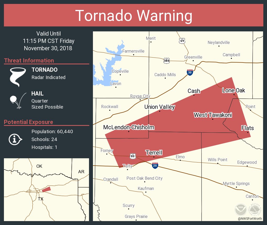
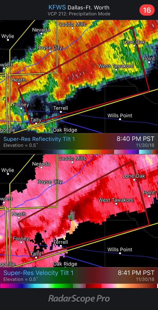
Nado sirens just turned off here. Threat was much further south near Terrell.
0 likes

Re: Texas Fall 2018
Haris wrote:[url]https://i.ibb.co/zSRS04w/gem-mslp-pcpn-frzn-scus-30.png [/url]
Few more degrees colder and a major storm!!!!!!
Lets do this!
0 likes
-
starsfan65

- Category 2

- Posts: 675
- Age: 46
- Joined: Thu Dec 17, 2015 1:18 pm
- Location: Garland,Tx
Re: Texas Fall 2018
passed away about an hour agoEnnisTx wrote:R.I.P President George H.W. Bush
2 likes
Re: Texas Fall 2018
FV3 is oh so close to something significant. Cold air aloft, plenty of qpf but just missing at surface. Very, very close nearby for DFW.
4 likes
The above post and any post by Ntxw is NOT an official forecast and should not be used as such. It is just the opinion of the poster and may or may not be backed by sound meteorological data. It is NOT endorsed by any professional institution including Storm2k. For official information, please refer to NWS products.
Help support Storm2K!
Help support Storm2K!

Re: Texas Fall 2018
Soooo.... Is it safe for me to start getting at least a little cautiously optimistic?? 
2 likes
-
weatherdude1108
- Category 5
- Posts: 4172
- Joined: Tue Dec 13, 2011 1:04 pm
- Location: Northwest Austin/Cedar Park, TX
Re: Texas Fall 2018
R.I.P George H,W, Bush.  Good man.
Meanwhile, thundering here with a lot of lightning. About to get a thunderstorm it seems. Fast moving.
Meanwhile, thundering here with a lot of lightning. About to get a thunderstorm it seems. Fast moving.
1 likes
The preceding post is NOT an official forecast, and should not be used as such. It is only the opinion of the poster and may or may not be backed by sound meteorological data. It is NOT endorsed by any professional institution including storm2k.org. For Official Information please refer to the NHC and NWS products.
Re: Texas Fall 2018
JayDT wrote:Soooo.... Is it safe for me to start getting at least a little cautiously optimistic??
Get your popcorn ready!
2 likes
-
Brent
- S2K Supporter
- Posts: 37123
- Age: 35
- Joined: Sun May 16, 2004 10:30 pm
- Location: Tulsa Oklahoma
- Contact:
Re: Texas Fall 2018
So sad about 41 but at least he's with Barbara again
See yall in the winter thread for hopefully a crazy start
See yall in the winter thread for hopefully a crazy start
3 likes
#neversummer
-
weatherdude1108
- Category 5
- Posts: 4172
- Joined: Tue Dec 13, 2011 1:04 pm
- Location: Northwest Austin/Cedar Park, TX
Re: Texas Fall 2018
Special Weather Statement
National Weather Service Austin/San Antonio TX
1100 PM CST FRI NOV 30 2018
TXZ172-173-192-010600-
Williamson TX-Burnet TX-Travis TX-
1100 PM CST FRI NOV 30 2018
...SIGNIFICANT WEATHER ADVISORY FOR WILLIAMSON...NORTHERN TRAVIS AND
SOUTHWESTERN BURNET COUNTIES UNTIL MIDNIGHT CST...
At 1100 PM CST, Doppler radar was tracking a strong thunderstorm over
Marble Falls, moving east at 60 mph.
Nickel size hail will be possible with this storm.
Locations impacted include...
Austin, Round Rock, Cedar Park, Georgetown, Pflugerville, Taylor,
Marble Falls, Granger, Bertram, Serenada, Anderson Mill, Windemere,
Leander, Hutto, Lago Vista, Hudson Bend, Bartlett, Meadowlakes,
Liberty Hill and Jarrell.
PRECAUTIONARY/PREPAREDNESS ACTIONS...
This storm may intensify, so be certain to monitor local radio
stations and available television stations for additional information
and possible warnings from the National Weather Service.
&&
1 likes
The preceding post is NOT an official forecast, and should not be used as such. It is only the opinion of the poster and may or may not be backed by sound meteorological data. It is NOT endorsed by any professional institution including storm2k.org. For Official Information please refer to the NHC and NWS products.
Re: Texas Fall 2018
EnnisTx wrote:JayDT wrote:Soooo.... Is it safe for me to start getting at least a little cautiously optimistic??
Get your popcorn ready!
Popcorn, chips, cookies, all kinds of snacks, and drinks of course.. Ive been waiting for this for way too long already
2 likes
Return to “USA & Caribbean Weather”
Who is online
Users browsing this forum: bubba hotep, ejburas and 47 guests