Texas Summer 2019

U.S. & Caribbean Weather Discussions and Severe Weather Events

Moderator: S2k Moderators

Forum rules

The posts in this forum are NOT official forecast and should not be used as such. They are just the opinion of the poster and may or may not be backed by sound meteorological data. They are NOT endorsed by any professional institution or STORM2K.

Help Support Storm2K
Message
Author
Brent
S2K Supporter
S2K Supporter
Posts: 37109
Age: 35
Joined: Sun May 16, 2004 10:30 pm
Location: Tulsa Oklahoma
Contact:

Re: Texas Summer 2019

#61 Postby Brent » Wed Jun 05, 2019 11:08 am

Cpv17 wrote:No telling how much rain I got here. My rain gauge stops at 5” and it’s overflowing. If I would’ve known we were supposed to get this much rain, I would’ve woken up in the middle of the night and dumped it out. Everything is flooded here.


8-10 inches reported on the warning near Wharton :double: :eek:
0 likes   
#neversummer

weatherdude1108
Category 5
Category 5
Posts: 4172
Joined: Tue Dec 13, 2011 1:04 pm
Location: Northwest Austin/Cedar Park, TX

Re: Texas Summer 2019

#62 Postby weatherdude1108 » Wed Jun 05, 2019 11:12 am

Brent wrote:
Cpv17 wrote:No telling how much rain I got here. My rain gauge stops at 5” and it’s overflowing. If I would’ve known we were supposed to get this much rain, I would’ve woken up in the middle of the night and dumped it out. Everything is flooded here.


8-10 inches reported on the warning near Wharton :double: :eek:


I was just wondering about you Cpv17(?). I saw this flood warning. :eek:

Flash Flood Warning
TXC015-039-089-157-239-321-473-481-051745-
/O.NEW.KHGX.FF.W.0022.190605T1449Z-190605T1745Z/
/00000.0.ER.000000T0000Z.000000T0000Z.000000T0000Z.OO/

BULLETIN - EAS ACTIVATION REQUESTED
Flash Flood Warning
National Weather Service Houston/Galveston TX
949 AM CDT Wed Jun 5 2019

The National Weather Service in League City has issued a

* Flash Flood Warning for...
East central Colorado County in southeastern Texas...
Wharton County in southeastern Texas...
Southeastern Austin County in southeastern Texas...
Southeastern Jackson County in south central Texas...
Fort Bend County in southeastern Texas...
Western Brazoria County in southeastern Texas...
South central Waller County in southeastern Texas...
Matagorda County in southeastern Texas...

* Until 1245 PM CDT.

* At 948 AM CDT, emergency management reported flash flooding in and
around the Wharton area. Numerous water rescues from vehicles are
occuring and a few homes are beginning to take on water. 8 to 10
inches of rain have fallen. Flash flooding is ongoing. Emergency
officials are urging people to stay home until the flood threat
has diminished.

* Some locations that will experience flooding include...
Southwestern Pearland, Sugar Land, Missouri City, Rosenberg,
Stafford, Bay City, Richmond, El Campo, Wharton, Sealy, Palacios,
Brookshire, West Columbia, Sweeny, South Texas Nuclear Plant,
Fresno, Town West, Pecan Grove, First Colony and Mission Bend.

Additional rainfall amounts of 1 to 3 inches are possible in the
warned area.

PRECAUTIONARY/PREPAREDNESS ACTIONS...

Turn around, don`t drown when encountering flooded roads. Most flood
deaths occur in vehicles.

A Flash Flood Warning means that flooding is imminent or occurring.
If you are in the warned area move to higher ground immediately.
Residents living along streams and creeks should take immediate
precautions to protect life and property.
0 likes   
The preceding post is NOT an official forecast, and should not be used as such. It is only the opinion of the poster and may or may not be backed by sound meteorological data. It is NOT endorsed by any professional institution including storm2k.org. For Official Information please refer to the NHC and NWS products.

User avatar
SoupBone
Category 5
Category 5
Posts: 3073
Joined: Tue Sep 20, 2005 5:24 pm

Re: Texas Summer 2019

#63 Postby SoupBone » Wed Jun 05, 2019 11:15 am

Cpv17 wrote:No telling how much rain I got here. My rain gauge stops at 5” and it’s overflowing. If I would’ve known we were supposed to get this much rain, I would’ve woken up in the middle of the night and dumped it out. Everything is flooded here.


According to the NOAA site, you got over 10".
0 likes   
Personal Forecast Disclaimer:
The posts in this forum are NOT official forecast and should not be used as such. They are just the opinion of the poster and may or may not be backed by sound meteorological data. They are NOT endorsed by any professional institution or storm2k.org. For official information, please refer to the NHC and NWS products.

Cpv17
Category 5
Category 5
Posts: 4330
Joined: Wed Dec 07, 2016 2:24 pm
Location: Wharton/El Campo, TX

Re: Texas Summer 2019

#64 Postby Cpv17 » Wed Jun 05, 2019 11:16 am

weatherdude1108 wrote:
Brent wrote:
Cpv17 wrote:No telling how much rain I got here. My rain gauge stops at 5” and it’s overflowing. If I would’ve known we were supposed to get this much rain, I would’ve woken up in the middle of the night and dumped it out. Everything is flooded here.


8-10 inches reported on the warning near Wharton :double: :eek:


I was just wondering about you Cpv17(?). I saw this flood warning. :eek:

Flash Flood Warning
TXC015-039-089-157-239-321-473-481-051745-
/O.NEW.KHGX.FF.W.0022.190605T1449Z-190605T1745Z/
/00000.0.ER.000000T0000Z.000000T0000Z.000000T0000Z.OO/

BULLETIN - EAS ACTIVATION REQUESTED
Flash Flood Warning
National Weather Service Houston/Galveston TX
949 AM CDT Wed Jun 5 2019

The National Weather Service in League City has issued a

* Flash Flood Warning for...
East central Colorado County in southeastern Texas...
Wharton County in southeastern Texas...
Southeastern Austin County in southeastern Texas...
Southeastern Jackson County in south central Texas...
Fort Bend County in southeastern Texas...
Western Brazoria County in southeastern Texas...
South central Waller County in southeastern Texas...
Matagorda County in southeastern Texas...

* Until 1245 PM CDT.

* At 948 AM CDT, emergency management reported flash flooding in and
around the Wharton area. Numerous water rescues from vehicles are
occuring and a few homes are beginning to take on water. 8 to 10
inches of rain have fallen. Flash flooding is ongoing. Emergency
officials are urging people to stay home until the flood threat
has diminished.

* Some locations that will experience flooding include...
Southwestern Pearland, Sugar Land, Missouri City, Rosenberg,
Stafford, Bay City, Richmond, El Campo, Wharton, Sealy, Palacios,
Brookshire, West Columbia, Sweeny, South Texas Nuclear Plant,
Fresno, Town West, Pecan Grove, First Colony and Mission Bend.

Additional rainfall amounts of 1 to 3 inches are possible in the
warned area.

PRECAUTIONARY/PREPAREDNESS ACTIONS...

Turn around, don`t drown when encountering flooded roads. Most flood
deaths occur in vehicles.

A Flash Flood Warning means that flooding is imminent or occurring.
If you are in the warned area move to higher ground immediately.
Residents living along streams and creeks should take immediate
precautions to protect life and property.


There’s even water in homes in places, power poles snapped in half, power lines down over roads.. crazy here.
1 likes   

User avatar
Haris
Category 5
Category 5
Posts: 1808
Joined: Mon Nov 27, 2017 8:19 pm
Location: ( Bee Cave) West Austin, Texas

Re: Texas Summer 2019

#65 Postby Haris » Wed Jun 05, 2019 11:23 am

Image

Tomorrow looks interesting
1 likes   
Weather geek and a storm spotter in West Austin. Not a degreed meteorologist. Big snow fan. Love rain and cold! Despise heat!

User avatar
SoupBone
Category 5
Category 5
Posts: 3073
Joined: Tue Sep 20, 2005 5:24 pm

Re: Texas Summer 2019

#66 Postby SoupBone » Wed Jun 05, 2019 11:27 am


Your image isn't displaying.
0 likes   
Personal Forecast Disclaimer:
The posts in this forum are NOT official forecast and should not be used as such. They are just the opinion of the poster and may or may not be backed by sound meteorological data. They are NOT endorsed by any professional institution or storm2k.org. For official information, please refer to the NHC and NWS products.

Cpv17
Category 5
Category 5
Posts: 4330
Joined: Wed Dec 07, 2016 2:24 pm
Location: Wharton/El Campo, TX

Re: Texas Summer 2019

#67 Postby Cpv17 » Wed Jun 05, 2019 11:59 am


Looks like that’s headed right towards me so there could be another round tomorrow here...after this it looks to be pretty dry for a while so hopefully everyone can get some decent rains the next couple days. We could go into a drought after this from what I’m seeing on the models. GFS looks terrible. All the rain shifts to the SE and nothing over Texas..how typical.
0 likes   

User avatar
wxman22
Category 3
Category 3
Posts: 825
Joined: Mon Jan 30, 2006 12:39 am
Location: Houston,Tx
Contact:

Re: Texas Summer 2019

#68 Postby wxman22 » Wed Jun 05, 2019 12:09 pm

:uarrow: You got over 10+ inches in your area..., the southeast has been very dry over the last few months...they can use some rain. We've had plenty of rain here locally in southeast Texas over the last month.
1 likes   

Cpv17
Category 5
Category 5
Posts: 4330
Joined: Wed Dec 07, 2016 2:24 pm
Location: Wharton/El Campo, TX

Re: Texas Summer 2019

#69 Postby Cpv17 » Wed Jun 05, 2019 12:28 pm

wxman22 wrote::uarrow: You got over 10+ inches in your area..., the southeast has been very dry over the last few months...they can use some rain. We've had plenty of rain here locally in southeast Texas over the last month.


I’m not just talking about my area though. We’ll be fine here now for the rest of the month, but I don’t want a death ridge to set up over Texas for the rest of the summer and that kind of looks like what the GFS is doing...well at least after tomorrow.
1 likes   

User avatar
Haris
Category 5
Category 5
Posts: 1808
Joined: Mon Nov 27, 2017 8:19 pm
Location: ( Bee Cave) West Austin, Texas

Re: Texas Summer 2019

#70 Postby Haris » Wed Jun 05, 2019 12:40 pm

just got enhanced risk!
1 likes   
Weather geek and a storm spotter in West Austin. Not a degreed meteorologist. Big snow fan. Love rain and cold! Despise heat!

User avatar
SoupBone
Category 5
Category 5
Posts: 3073
Joined: Tue Sep 20, 2005 5:24 pm

Re: Texas Summer 2019

#71 Postby SoupBone » Wed Jun 05, 2019 12:44 pm

Cpv17 wrote:
wxman22 wrote::uarrow: You got over 10+ inches in your area..., the southeast has been very dry over the last few months...they can use some rain. We've had plenty of rain here locally in southeast Texas over the last month.


I’m not just talking about my area though. We’ll be fine here now for the rest of the month, but I don’t want a death ridge to set up over Texas for the rest of the summer and that kind of looks like what the GFS is doing...well at least after tomorrow.


the death ridge is a nasty trade-off for being protected from tropical systems. I remember the one years ago was brutal.
0 likes   
Personal Forecast Disclaimer:
The posts in this forum are NOT official forecast and should not be used as such. They are just the opinion of the poster and may or may not be backed by sound meteorological data. They are NOT endorsed by any professional institution or storm2k.org. For official information, please refer to the NHC and NWS products.

Cpv17
Category 5
Category 5
Posts: 4330
Joined: Wed Dec 07, 2016 2:24 pm
Location: Wharton/El Campo, TX

Re: Texas Summer 2019

#72 Postby Cpv17 » Wed Jun 05, 2019 12:47 pm

SoupBone wrote:
Cpv17 wrote:
wxman22 wrote::uarrow: You got over 10+ inches in your area..., the southeast has been very dry over the last few months...they can use some rain. We've had plenty of rain here locally in southeast Texas over the last month.


I’m not just talking about my area though. We’ll be fine here now for the rest of the month, but I don’t want a death ridge to set up over Texas for the rest of the summer and that kind of looks like what the GFS is doing...well at least after tomorrow.


the death ridge is a nasty trade-off for being protected from tropical systems. I remember the one years ago was brutal.


I remember growing up as a kid we would have a 20 or 30% for afternoon pop ups almost every day. Whatever happened to those days.
2 likes   

weatherdude1108
Category 5
Category 5
Posts: 4172
Joined: Tue Dec 13, 2011 1:04 pm
Location: Northwest Austin/Cedar Park, TX

Re: Texas Summer 2019

#73 Postby weatherdude1108 » Wed Jun 05, 2019 2:11 pm

Haris wrote:just got enhanced risk!


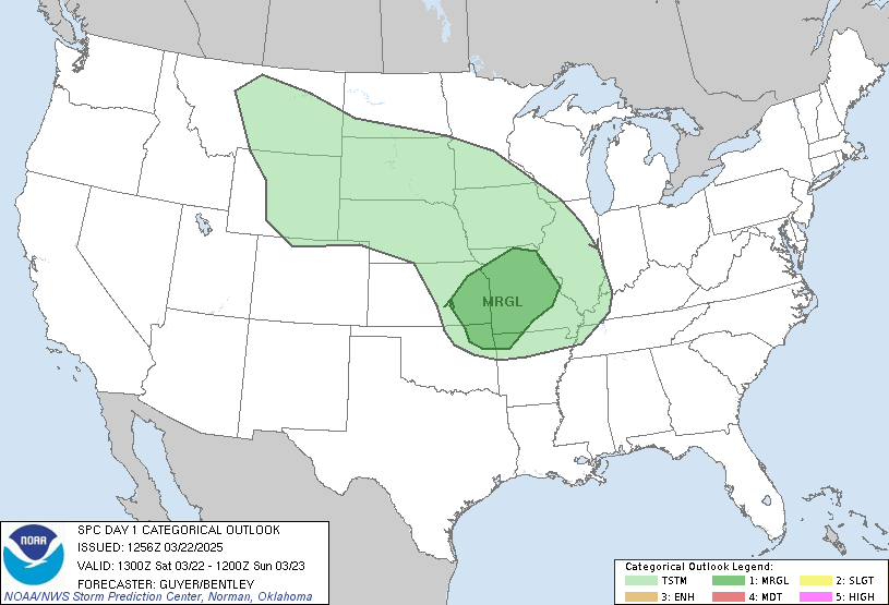
I was shocked by that. I read up on the discussion. They mentioned an area of drier mid-level air in our area, developing a cold pool-driven MCS, with a scattered large hail threat initially around the Edwards Plateau/Hill Country, and subsequent increased wind potential downstream towards I35 and the coastal plains. I may or may not take off a couple hours early tomorrow. Have to see what happens with the mesoscale features.

...TX into the Central Gulf Coast States...
A closed upper low initially centered over the southern High Plains
is forecast to slowly move eastward towards the lower MS Valley
through the period. A belt of somewhat enhanced mid-level westerly
winds (around 30-45 kt) will likely be present across much of TX to
the central Gulf Coast region, and a strongly veering wind profile
should support 35-45 kt of effective bulk shear across much of
central/east TX by Thursday afternoon. Ample heating of a very moist
low-level airmass will occur from the Edwards Plateau eastward
across the Hill Country and into the Coastal Plain of TX, and MLCAPE
of 1500-3000+ J/kg will likely develop across these areas.
Convective development should occur by Thursday afternoon in the
vicinity of the Edwards Plateau
as a mid/upper-level speed maximum
overspreads this area.

Given the forecast combination of instability and shear, supercells
appear probable initially, with both scattered large hail and
damaging wind threats. There is concern that upscale growth into an
MCS with potential for at least scattered damaging winds may occur
across parts of the Hill Country into the middle TX Coastal Plain
late Thursday afternoon into the evening. Somewhat drier mid-level
air noted on forecast soundings across this region should encourage
development of a substantial cold pool, and 12Z convection-allowing
model guidance is showing this increased wind potential in a
relatively focused corridor. Have therefore increased severe
probabilities for parts of this area in TX to account for the
likelihood of both scattered large hail initially and damaging winds
later in the convective life cycle
.


https://www.spc.ncep.noaa.gov/products/ ... 2otlk.html
1 likes   
The preceding post is NOT an official forecast, and should not be used as such. It is only the opinion of the poster and may or may not be backed by sound meteorological data. It is NOT endorsed by any professional institution including storm2k.org. For Official Information please refer to the NHC and NWS products.

Cpv17
Category 5
Category 5
Posts: 4330
Joined: Wed Dec 07, 2016 2:24 pm
Location: Wharton/El Campo, TX

Re: Texas Summer 2019

#74 Postby Cpv17 » Wed Jun 05, 2019 2:44 pm

weatherdude1108 wrote:
Haris wrote:just got enhanced risk!


I was shocked by that. I read up on the discussion. They mentioned an area of drier mid-level air in our area, developing a cold pool-driven MCS, with a scattered large hail threat initially around the Edwards Plateau/Hill Country, and subsequent increased wind potential downstream towards I35 and the coastal plains. I may or may not take off a couple hours early tomorrow. Have to see what happens with the mesoscale features.

...TX into the Central Gulf Coast States...
A closed upper low initially centered over the southern High Plains
is forecast to slowly move eastward towards the lower MS Valley
through the period. A belt of somewhat enhanced mid-level westerly
winds (around 30-45 kt) will likely be present across much of TX to
the central Gulf Coast region, and a strongly veering wind profile
should support 35-45 kt of effective bulk shear across much of
central/east TX by Thursday afternoon. Ample heating of a very moist
low-level airmass will occur from the Edwards Plateau eastward
across the Hill Country and into the Coastal Plain of TX, and MLCAPE
of 1500-3000+ J/kg will likely develop across these areas.
Convective development should occur by Thursday afternoon in the
vicinity of the Edwards Plateau
as a mid/upper-level speed maximum
overspreads this area.

Given the forecast combination of instability and shear, supercells
appear probable initially, with both scattered large hail and
damaging wind threats. There is concern that upscale growth into an
MCS with potential for at least scattered damaging winds may occur
across parts of the Hill Country into the middle TX Coastal Plain
late Thursday afternoon into the evening. Somewhat drier mid-level
air noted on forecast soundings across this region should encourage
development of a substantial cold pool, and 12Z convection-allowing
model guidance is showing this increased wind potential in a
relatively focused corridor. Have therefore increased severe
probabilities for parts of this area in TX to account for the
likelihood of both scattered large hail initially and damaging winds
later in the convective life cycle
.


https://www.spc.ncep.noaa.gov/products/ ... 2otlk.html


Wasn’t expecting this at all.
0 likes   

Brent
S2K Supporter
S2K Supporter
Posts: 37109
Age: 35
Joined: Sun May 16, 2004 10:30 pm
Location: Tulsa Oklahoma
Contact:

Re: Texas Summer 2019

#75 Postby Brent » Wed Jun 05, 2019 4:05 pm

still dont see much reason to complain, even this weekend's heat wave(which was mid to upper 90s) is backing off closer to normal up here and another front seems plausible beyond that
1 likes   
#neversummer

User avatar
Rgv20
S2K Supporter
S2K Supporter
Posts: 2456
Age: 37
Joined: Wed Jan 05, 2011 5:42 pm
Location: Edinburg/McAllen Tx

Re: Texas Summer 2019

#76 Postby Rgv20 » Wed Jun 05, 2019 5:01 pm

NWS Brownsville afternoon discussion....a bit toasty this weekend :sun:

.LONG TERM (Friday through Wednesday): The long term period begins
with a mid level trough slowly meandering from the Plains into
the SE, with a ridge building over Mexico. With high pressure in
control and dry air aloft, any thunderstorm chance will become
capped off Friday afternoon, and temperatures are expected to bump
well above normal through the weekend. Highs on Saturday and
Sunday could approach 112 degrees out west, with 100 degrees into
the lower valley. With the entire RGV forecast to top off near or
above 100, Heat Advisories are likely, and an Excessive Heat Watch
may be needed, with Excessive Heat Warnings possible.
0 likes   
The following post is NOT an official forecast and should not be used as such. It is just the opinion of the poster and may or may not be backed by sound meteorological data. It is NOT endorsed by any professional institution including storm2k.org For Official Information please refer to the NHC and NWS products.

User avatar
bubba hotep
S2K Supporter
S2K Supporter
Posts: 5476
Joined: Wed Dec 28, 2016 1:00 am
Location: Collin County Texas

Re: Texas Summer 2019

#77 Postby bubba hotep » Wed Jun 05, 2019 9:45 pm

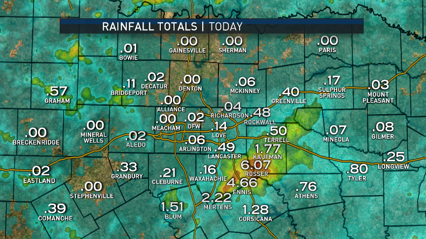
So close, yet so far away

Image
2 likes   
Winter time post are almost exclusively focused on the DFW area.

User avatar
CaptinCrunch
S2K Supporter
S2K Supporter
Posts: 8576
Age: 56
Joined: Mon Nov 03, 2003 4:33 pm
Location: Lake Worth, TX (Tarrant Co.)

Re: Texas Summer 2019

#78 Postby CaptinCrunch » Thu Jun 06, 2019 9:32 am

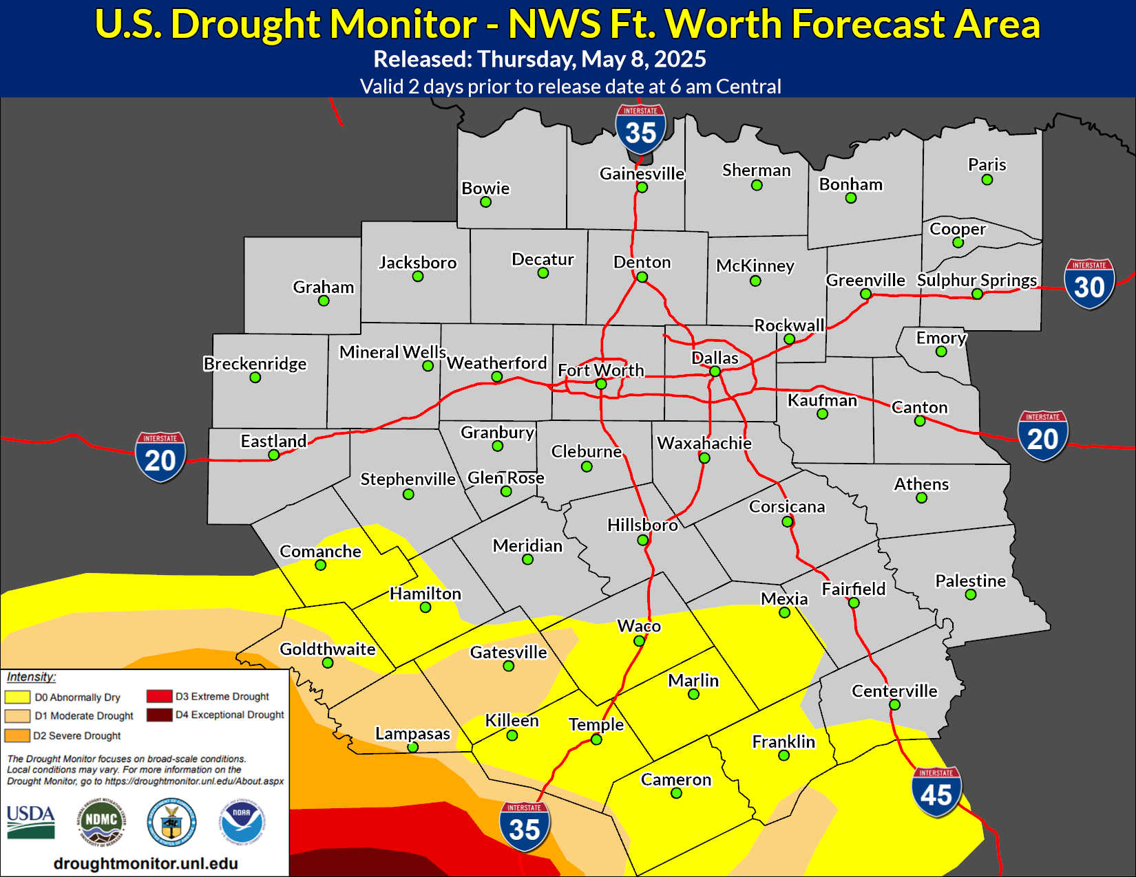
I think models over estimated the precip for NTX this go around, have only saw lite showers in the over night hours.

Delkus talked up his Summer outlook again lastnight, going with a slightly cooler and wetter than avg Jun-Aug forecast because of the ongoing El Nino. While I do think the current El Nino will continue through late Winter, this summer is going to be sticky and humid so stock up on deodorant now. :fantastic: :break:
2 likes   

Cpv17
Category 5
Category 5
Posts: 4330
Joined: Wed Dec 07, 2016 2:24 pm
Location: Wharton/El Campo, TX

Re: Texas Summer 2019

#79 Postby Cpv17 » Thu Jun 06, 2019 11:12 am

We had 8” at my house yesterday, a severe thunderstorm this morning around 6am, and more severe storms expected later this afternoon. Exciting times for me over here lol

Image
3 likes   

User avatar
CaptinCrunch
S2K Supporter
S2K Supporter
Posts: 8576
Age: 56
Joined: Mon Nov 03, 2003 4:33 pm
Location: Lake Worth, TX (Tarrant Co.)

Re: Texas Summer 2019

#80 Postby CaptinCrunch » Thu Jun 06, 2019 3:06 pm

Image

Well DUH!! :ggreen:
2 likes   


Return to “USA & Caribbean Weather”

Who is online

Users browsing this forum: No registered users and 149 guests