Texas Spring 2020
Moderator: S2k Moderators
Forum rules

The posts in this forum are NOT official forecast and should not be used as such. They are just the opinion of the poster and may or may not be backed by sound meteorological data. They are NOT endorsed by any professional institution or STORM2K.
-
wxman57

- Moderator-Pro Met

- Posts: 22482
- Age: 66
- Joined: Sat Jun 21, 2003 8:06 pm
- Location: Houston, TX (southwest)
Re: Texas Spring 2020
Some ice not far from north Texas on the 12z GFS valid St. Patrick's Day. Y'all getting excited up there?
4 likes
Re: Texas Spring 2020
wxman57 wrote:Some ice not far from north Texas on the 12z GFS valid St. Patrick's Day. Y'all getting excited up there?
The closest ice on St. Patrick's day will be in my freezer..
4 likes
-
Brent
- S2K Supporter

- Posts: 37099
- Age: 35
- Joined: Sun May 16, 2004 10:30 pm
- Location: Tulsa Oklahoma
- Contact:
Re: Texas Spring 2020
gpsnowman wrote:wxman57 wrote:Some ice not far from north Texas on the 12z GFS valid St. Patrick's Day. Y'all getting excited up there?
The closest ice on St. Patrick's day will be in my freezer..
Lol tell me about it
I was in Philadelphia today for a day trip(been in NY/Boston the last few days) and let me tell you... I almost got hot walking around. Winter is dead and gone.
Even in Boston I overheard some guy talking about his snow shovel was collecting dust(the snowstorm on the models last week was about 10 flakes)
2 likes
#neversummer
Re: Texas Spring 2020
Looks like y’all north TX folks are about to get hammered with severe weather and flooding over the next couple weeks.
0 likes
-
bubba hotep

- S2K Supporter
- Posts: 5459
- Joined: Wed Dec 28, 2016 1:00 am
- Location: Collin County Texas

Re: Texas Spring 2020
87 degrees out. A little early for that nonsense. I am ready for all the rain.
2 likes

Re: Texas Spring 2020
gpsnowman wrote:87 degrees out. A little early for that nonsense. I am ready for all the rain.
I'm loving it, the warm feels good. Agree completely on the rain - always a good thing.
1 likes
The above post and any post by dhweather is NOT an official forecast and should not be used as such. It is just the opinion of the poster and may or may not be backed by sound meteorological data. It is NOT endorsed by any professional institution including storm2k.org. For official information, please refer to NWS products.
-
Brent
- S2K Supporter
- Posts: 37099
- Age: 35
- Joined: Sun May 16, 2004 10:30 pm
- Location: Tulsa Oklahoma
- Contact:
Re: Texas Spring 2020
I just got back last night so I missed the 87 but I'm ready for the rain  Didn't see much when I was on vacation
1 likes
#neversummer
Re: Texas Spring 2020
Man, this place is completely dead. Even more dead than at any point we just had during our dreadful winter.
1 likes
-
Texas Snowman

- Storm2k Moderator

- Posts: 6011
- Joined: Fri Jan 25, 2008 11:29 am
- Location: Denison, Texas
Re: Texas Spring 2020
371
WWUS54 KSJT 130749
SVSSJT
Severe Weather Statement
National Weather Service San Angelo TX
249 AM CDT Fri Mar 13 2020
TXC081-451-130815-
/O.CON.KSJT.TO.W.0001.000000T0000Z-200313T0815Z/
Coke TX-Tom Green TX-
249 AM CDT Fri Mar 13 2020
...A TORNADO WARNING REMAINS IN EFFECT UNTIL 315 AM CDT FOR SOUTHERN COKE AND NORTH CENTRAL TOM GREEN COUNTIES...
At 249 AM CDT, a severe thunderstorm capable of producing a tornado was located near Water Valley, or 17 miles southwest of Robert Lee, moving east at 35 mph.
HAZARD...Tornado and quarter size hail.
SOURCE...Weather spotters reported a funnel cloud.
IMPACT...Flying debris will be dangerous to those caught without shelter. Mobile homes will be damaged or destroyed. Damage to roofs, windows, and vehicles will occur. Tree damage is likely.
This tornadic thunderstorm will remain over mainly rural areas of southern Coke and north central Tom Green Counties, including the following locations...
The Intersection Of Highway 208 And Ranch Road 2662 and Us-87 Near The Coke-Tom Green County Line.
PRECAUTIONARY/PREPAREDNESS ACTIONS...
TAKE COVER NOW! Move to a basement or an interior room on the lowest floor of a sturdy building. Avoid windows. If you are outdoors, in a mobile home, or in a vehicle, move to the closest substantial shelter and protect yourself from flying debris.
&&
LAT...LON 3160 10078 3178 10081 3188 10024 3168 10024
TIME...MOT...LOC 0749Z 259DEG 31KT 3171 10069
TORNADO...RADAR INDICATED
HAIL...1.00IN
$$
0 likes
The above post and any post by Texas Snowman is NOT an official forecast and should not be used as such. It is just the opinion of the poster and may or may not be backed by sound meteorological data. It is NOT endorsed by any professional institution including storm2k.org. For official information, please refer to NWS products.

Re: Texas Spring 2020
Crazy how dead it is with these massive rain totals in store. I can't remember the last time I've seen such a large 5-7 inch area on the WPC 7 Day map.
1 likes
Re: Texas Spring 2020
DonWrk wrote:Crazy how dead it is with these massive rain totals in store. I can't remember the last time I've seen such a large 5-7 inch area on the WPC 7 Day map.
It’s crazy because most of the people on here are from the DFW area and that’s the area that looks like it’s really gonna get hammered and still no chatter about it on here. Severe weather threat looks to be on the tabs too.
0 likes
Re: Texas Spring 2020
Cpv17 wrote:DonWrk wrote:Crazy how dead it is with these massive rain totals in store. I can't remember the last time I've seen such a large 5-7 inch area on the WPC 7 Day map.
It’s crazy because most of the people on here are from the DFW area and that’s the area that looks like it’s really gonna get hammered and still no chatter about it on here. Severe weather threat looks to be on the tabs too.
I'm here but at work currently. We did have some massive downpours earlier with much more on the way the next week. If it's gonna spring, let it spring!!!
0 likes
-
weatherdude1108
- Category 5

- Posts: 4172
- Joined: Tue Dec 13, 2011 1:04 pm
- Location: Northwest Austin/Cedar Park, TX
Re: Texas Spring 2020
I think everyone is probably preoccupied with other current events going on.
Being outside viewing the storms might be the best place to be!
Being outside viewing the storms might be the best place to be!
2 likes
The preceding post is NOT an official forecast, and should not be used as such. It is only the opinion of the poster and may or may not be backed by sound meteorological data. It is NOT endorsed by any professional institution including storm2k.org. For Official Information please refer to the NHC and NWS products.

Re: Texas Spring 2020
Yep, I am up in Roanoke N of Ft Worth. The line of storms blasted through with some gusty winds 35-40MPH and very heavy rain. Looks like W TX is going to see some action starting in the next few hours.
0 likes
The following post is NOT an official forecast and should not be used as such. It is just the opinion of the poster and may or may not be backed by sound meteorological data. It is NOT endorsed by any professional institution including storm2k.org For Official Information please refer to the NHC and NWS products.
-
1900hurricane

- Category 5
- Posts: 6044
- Age: 32
- Joined: Fri Feb 06, 2015 12:04 pm
- Location: Houston, TX
- Contact:
Re: Texas Spring 2020
Hey y'all! Since NCAA March Madness got canceled and we're weather enthusiasts here, I put together a March Madness Bracket of sorts for tropical cyclones! Check it on the thread here or in the Twitter thread beginning below!
https://twitter.com/1900hurricane/status/1238975016223547393
https://twitter.com/1900hurricane/status/1238975016223547393
3 likes
Contract Meteorologist. TAMU & MSST. Fiercely authentic, one of a kind. We are all given free will, so choose a life meant to be lived. We are the Masters of our own Stories.
Opinions expressed are mine alone.
Follow me on Twitter at @1900hurricane : Read blogs at https://1900hurricane.wordpress.com/
Opinions expressed are mine alone.
Follow me on Twitter at @1900hurricane : Read blogs at https://1900hurricane.wordpress.com/
-
bubba hotep
- S2K Supporter
- Posts: 5459
- Joined: Wed Dec 28, 2016 1:00 am
- Location: Collin County Texas
Re: Texas Spring 2020
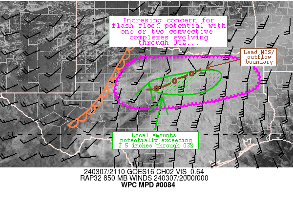
Mesoscale Precipitation Discussion 0084
NWS Weather Prediction Center College Park MD
1200 AM EDT Sun Mar 15 2020
Areas affected...Northeast TX...Extreme Southeast OK...Southwest
to Central AR
Concerning...Heavy rainfall...Flash flooding possible
Valid 150400Z - 150900Z
SUMMARY...Some isolated flash flooding potential exists overnight
from locally training showers and thunderstorms.
DISCUSSION...The latest GOES-16 satellite imagery is showing an
area of rapid convective cloud top cooling over portions of
northeast TX, generally involving portions of Collin, Hunt and
Delta counties. Showers and thunderstorms have been developing
across this region in response to a notable increase in elevated
instability north of a quasi-stationary front, and within an zone
of favorable right-entrance region jet dynamics. In fact, 3-hour
MUCAPE delta values across much of central to northeast TX, and
across central AR have been on the order of 400 to 500 j/kg.
Already the latest dual-pol radar estimates have shown some peak
rainfall rates of as much as 1.5 inches/hr, and some localized
training of cells that has resulted in storm totals of as much as
2 to 3+ inches.
Over the next few hours, the corridor of stronger jet-aided
forcing aloft should translate downstream across areas of
southwest and central AR, and parallel to the aforementioned
elevated instability axis with overall MUCAPE values of 1000+
j/kg. This coupled with increasingly confluent flow in vicinity of
the 850/925 mb frontal placement should result in an expanding
axis of showers and thunderstorms, with activity likely continuing
to redevelop over areas of northeast Texas, but expanding in
coverage downstream across areas of southwest and central AR.
PWs across the lower MS Valley are on the order of 1.5 to 1.7
inches which are about 2 to 2.5 standard deviations above normal
for this time of the year. Some of the anomalous moisture
contribution is certainly connected to the southwesterly mid-level
(700/500 mb) flow emanating from the eastern tropical Pacific
Ocean, where the latest CIRA-LPW data is showing a well-defined
zone of moisture transport.
Given the anomalously higher PWs and efficient mid-level moisture
transport, the rainfall rates within the deeper convective cores
should remain quite high, with rates that perhaps even locally
approaching 2 inches/hr. This coupled with a fairly decent set-up
for some periodic training of cells should result in a threat of
locally excessive totals. The 00Z HREF suite of guidance favors
some additional storm totals of as much as 3 inches going toward
dawn, which may perhaps be a tad underdone given the instability
and moisture parameters that are in place. As a result, at least
some isolated areas of flash flooding will be possible going
through the remainder of the overnight time-frame.
Orrison
ATTN...WFO...FWD...LZK...OUN...SHV...TSA...
0 likes
Winter time post are almost exclusively focused on the DFW area.
-
bubba hotep
- S2K Supporter
- Posts: 5459
- Joined: Wed Dec 28, 2016 1:00 am
- Location: Collin County Texas
Re: Texas Spring 2020
Lake levels look good across N. Texas with more rain on the way.

1 likes
Winter time post are almost exclusively focused on the DFW area.
-
bubba hotep
- S2K Supporter
- Posts: 5459
- Joined: Wed Dec 28, 2016 1:00 am
- Location: Collin County Texas
Re: Texas Spring 2020
Legit long lasting t-storm ongoing right now 
2 likes
Winter time post are almost exclusively focused on the DFW area.
Return to “USA & Caribbean Weather”
Who is online
Users browsing this forum: bubba hotep, Google [Bot], Google Adsense [Bot] and 157 guests