Page 28 of 30
Re: Texas Fall 2020
Posted: Tue Nov 24, 2020 9:18 pm
by cheezyWXguy
cheezyWXguy wrote:Storms are pretty numerous, but not too strong. Probably having trouble getting rooted to the surface, given the cap. Plus they’re close to the front which minimizes their ability to capitalize on the SRH without being undercut. Things could change, but I prefer they don’t. A decent quick rain with some lightning sounds pretty good right about now.
This didn’t age well, haha
Re: Texas Fall 2020
Posted: Tue Nov 24, 2020 9:24 pm
by HockeyTx82
I took some good ones too, don't have a good way to share
Re: Texas Fall 2020
Posted: Tue Nov 24, 2020 9:26 pm
by bubba hotep
Might have another tornado moving into NW Collin County but no warning on that yet.
Re: Texas Fall 2020
Posted: Tue Nov 24, 2020 9:30 pm
by bubba hotep
Re: Texas Fall 2020
Posted: Tue Nov 24, 2020 9:52 pm
by Texas Snowman
Pretty big blow up here in northern Grayson County. Lots of wind and more than a half-inch of rain in a half hour.
If only it would snow like that!

Re: Texas Fall 2020
Posted: Tue Nov 24, 2020 9:53 pm
by cheezyWXguy
Could be a circulation forming on the cell in Arlington. Dallas needs to watch this.
Re: Texas Fall 2020
Posted: Tue Nov 24, 2020 10:03 pm
by bubba hotep
Re: Texas Fall 2020
Posted: Tue Nov 24, 2020 10:04 pm
by Texas Snowman
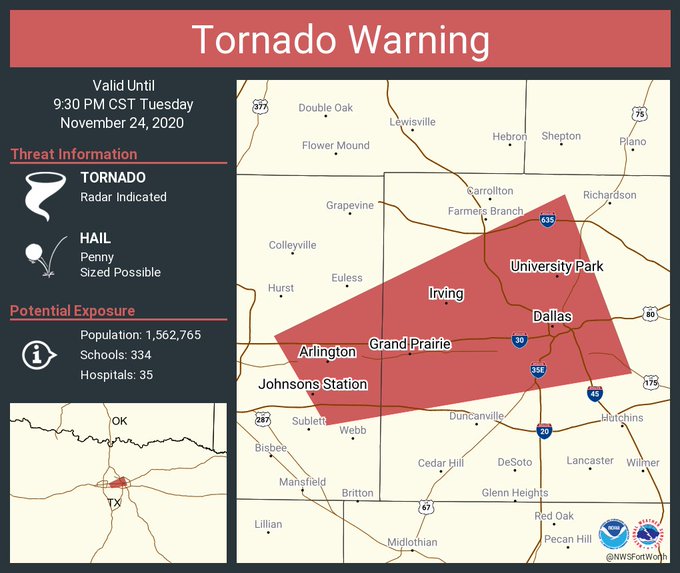
671
WFUS54 KFWD 250258
TORFWD
TXC113-439-250330-
/O.NEW.KFWD.TO.W.0037.201125T0258Z-201125T0330Z/
BULLETIN - EAS ACTIVATION REQUESTED
Tornado Warning
National Weather Service Fort Worth TX
858 PM CST Tue Nov 24 2020
The National Weather Service in Fort Worth has issued a
* Tornado Warning for...
East central Tarrant County in north central Texas...
Northwestern Dallas County in north central Texas...
* Until 930 PM CST.
* At 858 PM CST, a severe thunderstorm capable of producing a tornado
was located near Grand Prairie, moving east at 45 mph.
HAZARD...Tornado.
SOURCE...Radar indicated rotation.
IMPACT...Flying debris will be dangerous to those caught without
shelter. Mobile homes will be damaged or destroyed.
Damage to roofs, windows, and vehicles will occur. Tree
damage is likely.
* This dangerous storm will be near...
Cockrell Hill around 910 PM CST.
Highland Park around 920 PM CST.
University Park around 925 PM CST.
PRECAUTIONARY/PREPAREDNESS ACTIONS...
TAKE COVER NOW! Move to an interior room on the lowest floor of a
sturdy building. Avoid windows. If you are outdoors, in a mobile
home, or in a vehicle, move to the closest substantial shelter and
protect yourself from flying debris.
&&
LAT...LON 3265 9711 3277 9718 3296 9679 3272 9670
TIME...MOT...LOC 0258Z 250DEG 39KT 3272 9706
TORNADO...RADAR INDICATED
HAIL...<.75IN
$$
--
NWS Warnings Provided by AllisonHouse.com
Re: Texas Fall 2020
Posted: Tue Nov 24, 2020 10:19 pm
by bubba hotep
That Bow looks like it is tracking right over the airport..
Re: Texas Fall 2020
Posted: Tue Nov 24, 2020 10:43 pm
by Brent
Well that was interesting for a bit
At least it finally really rained
Re: Texas Fall 2020
Posted: Tue Nov 24, 2020 10:47 pm
by bubba hotep
Straight up gully washer here!
Re: Texas Fall 2020
Posted: Tue Nov 24, 2020 11:01 pm
by Texas Snowman
Looks like some significant wind damage in Arlington. Even talk of a possible tornado.
Whether it was a tornado or straight line wind damage, pics on Twitter showing damage to trees and even a few buildings.
Re: Texas Fall 2020
Posted: Tue Nov 24, 2020 11:02 pm
by Texas Snowman
@ArlingtonTxFire - The Arlington Fire Department and @ArlingtonPD have responded to multiple locations in Arlington with reports of collapsed buildings. Our units are currently assessing the structures, triaging potential patients, and moving to other reported locations. We will keep you updated.
Re: Texas Fall 2020
Posted: Tue Nov 24, 2020 11:04 pm
by Texas Snowman
@TxStormChasers - 937PM: Do *NOT* go to Arlington to sight-see. Search and rescue operations (simply to check damaged areas at a minimum) are underway by emergency crews. Do not clog roadways. #dfwwx
Re: Texas Fall 2020
Posted: Wed Nov 25, 2020 12:37 am
by Texas Snowman
Wow, looking at the Twitter photos, there is certainly a fair amount of damage in Arlington. Clearly, something out of the ordinary happened there tonight.
Re: Texas Fall 2020
Posted: Wed Nov 25, 2020 12:39 am
by Texas Snowman
@ArlingtonPD - Continuing to assist @ArlingtonTxFire at a few locations tonight due to roof collapses and debris field. Pioneer Parkway is closed in both directions between Center Street and Collins Street due to debris from area apartment complexes on roadway.
Re: Texas Fall 2020
Posted: Wed Nov 25, 2020 1:51 pm
by Texas Snowman
@NWSFortWorth - 12:17 PM: Our survey team has found EF-2 damage in south Arlington, near Pioneer Pkwy & S Center St. Estimated max winds of 115 mph. We will have more information on the path length and width later today.
Here's a snapshot of the radar last night. #dfwwx #ctxwx
Re: Texas Fall 2020
Posted: Wed Nov 25, 2020 1:54 pm
by TheProfessor
My Ohio friends are going crazy right now

The teleconnections favor something big happening on the east coast, however, it will come down to how strong that first storm is. Meanwhile the current Euro run shows a bit of wintry mischief for NW Texas. The 2nd storm is the one to watch imo, it could really dig behind the first one. I do think we're look at quite a unique pattern the next few weeks with the warm PDO and La Nina combination. I think we might see some more potent severe weather events but further west over the Southern Plains this winter. If the PDO inexplicably stays positive then I think this will be a fun winter for the DFW folks if you can find some cold.
Re: Texas Fall 2020
Posted: Wed Nov 25, 2020 2:10 pm
by Ntxw
TheProfessor wrote:My Ohio friends are going crazy right now
The teleconnections favor something big happening on the east coast, however, it will come down to how strong that first storm is. Meanwhile the current Euro run shows a bit of wintry mischief for NW Texas. The 2nd storm is the one to watch imo, it could really dig behind the first one. I do think we're look at quite a unique pattern the next few weeks with the warm PDO and La Nina combination. I think we might see some more potent severe weather events but further west over the Southern Plains this winter. If the PDO inexplicably stays positive then I think this will be a fun winter for the DFW folks if you can find some cold.
The extreme +PNA is going to drive something nuts. There isn't a ton of cold air around but big ULL systems we can work with. I'm not a huge fan of the +PNA for the south central states but it can work too if there is something digging or hanging back.
Re: Texas Fall 2020
Posted: Wed Nov 25, 2020 2:22 pm
by Brent
Only 200 hours out