Page 45 of 46
Re: Texas Spring 2021
Posted: Fri May 28, 2021 6:30 am
by bubba hotep
gpsnowman wrote:Bust city. Just woke up and from what I can tell not a drop fell here, at least in Irving anyway.
Massive bust. 100% chance of storms lol
I give up.
Re: Texas Spring 2021
Posted: Fri May 28, 2021 8:05 am
by rwfromkansas
Yep, 0 inches. Lol.
Re: Texas Spring 2021
Posted: Fri May 28, 2021 9:44 am
by HockeyTx82
Well Ponder and Denton got rocked. That wind was going hard. It was about 3AM ish..... woke me up and we grabbed the kids from upstairs and brought them down just incase.
Re: Texas Spring 2021
Posted: Fri May 28, 2021 10:10 am
by dhweather
We had 0.19" fall in Heath around 2AM, gusts to 30.
Re: Texas Spring 2021
Posted: Fri May 28, 2021 10:50 am
by bubba hotep
HockeyTx82 wrote:Well Ponder and Denton got rocked. That wind was going hard. It was about 3AM ish..... woke me up and we grabbed the kids from upstairs and brought them down just incase.
Looking at reports, it looks like the line fell apart as it moved into DFW. As you mention above, reports show decent rain totals up north but Alliance, DFW, & Love all reported 0.00".
The front is still to our NW and the outflow didn't totally stabilize the DFW area, so maybe better storm coverage this afternoon than currently anticipated?
Re: Texas Spring 2021
Posted: Fri May 28, 2021 12:38 pm
by dhweather
Storms initiating southwest of the Metroplex, we will see if any make it here. 2-3 severe thunderstorm warnings already issued.
Re: Texas Spring 2021
Posted: Fri May 28, 2021 3:31 pm
by Ntxw
DFW proper has been kind of unlucky yesterday and today with the best forcing to the north and then today to the south.
Re: Texas Spring 2021
Posted: Fri May 28, 2021 7:34 pm
by JDawg512
We got slammed in Austin. Impressive wind and torrential rain.
Re: Texas Spring 2021
Posted: Fri May 28, 2021 7:39 pm
by Haris
60mph winds and torrential rains down here indeed.
Re: Texas Spring 2021
Posted: Sat May 29, 2021 2:18 am
by South Texas Storms
Wow what a night! The San Antonio International Airport had a wind gust of 77 mph when those storms rolled through earlier!
Re: Texas Spring 2021
Posted: Sat May 29, 2021 6:38 am
by gpsnowman
Nice to see some southern members got beneficial rains. After all the rain and storms predicted for DFW, I didn't see one drop. On to the next round.
Re: Texas Spring 2021
Posted: Sat May 29, 2021 10:45 am
by bubba hotep
IIRC, that deep S. Texas MCS wasn't well forecasted? It probably knocked out the last of the drought down there.

Then the pattern looks to stay wet during the 1st half of June. At some point we might have to start considering that a below normal temp and above normal precipitation summer might be in the cards for Texas.

Re: Texas Spring 2021
Posted: Sat May 29, 2021 12:01 pm
by rwfromkansas
Those are impressive numbers for the West Texas desert. Wow. 3 inches would be 1/4 of the annual rainfall.
Re: Texas Spring 2021
Posted: Sat May 29, 2021 10:25 pm
by Texas Snowman
Multi vortex wedge tornado approaching Boise City, Oklahoma. PDS tornado warning, headed SE and could make it into the Texas Panhandle...
————-
880
WWUS54 KAMA 300311
SVSAMA
Severe Weather Statement
National Weather Service Amarillo TX
1011 PM CDT Sat May 29 2021
OKC025-300345-
/O.CON.KAMA.TO.W.0025.000000T0000Z-210530T0345Z/
Cimarron OK-
1011 PM CDT Sat May 29 2021
...A TORNADO WARNING REMAINS IN EFFECT UNTIL 1045 PM CDT FOR CENTRAL
CIMARRON COUNTY...
At 1010 PM CDT, a confirmed large and extremely dangerous tornado was
located 12 miles northwest of Boise City, moving southeast at 20 mph.
This is a PARTICULARLY DANGEROUS SITUATION. TAKE COVER NOW!
HAZARD...Damaging tornado.
SOURCE...Storm chaser confirmed a large tornado causing damage 12
miles northwest of Boise City.
IMPACT...You are in a life-threatening situation. Flying debris may
be deadly to those caught without shelter. Mobile homes
will be destroyed. Considerable damage to homes,
businesses, and vehicles is likely and complete destruction
is possible.
Locations impacted include...
Boise City.
PRECAUTIONARY/PREPAREDNESS ACTIONS...
Tornadoes are extremely difficult to see and confirm at night. Do not
wait to see or hear the tornado. TAKE COVER NOW!
A large and extremely dangerous tornado is on the ground. take
immediate tornado precautions. this is an emergency situation.
&&
LAT...LON 3685 10281 3698 10263 3685 10234 3658 10266
TIME...MOT...LOC 0310Z 316DEG 11KT 3683 10273
TORNADO...OBSERVED
TORNADO DAMAGE THREAT...CONSIDERABLE
HAIL...2.75IN
$$
--
Re: Texas Spring 2021
Posted: Sat May 29, 2021 10:27 pm
by Texas Snowman
Continues on the ground...
————
028
WWUS54 KAMA 300324
SVSAMA
Severe Weather Statement
National Weather Service Amarillo TX
1024 PM CDT Sat May 29 2021
OKC025-300345-
/O.CON.KAMA.TO.W.0025.000000T0000Z-210530T0345Z/
Cimarron OK-
1024 PM CDT Sat May 29 2021
...A TORNADO WARNING REMAINS IN EFFECT UNTIL 1045 PM CDT FOR CENTRAL
CIMARRON COUNTY...
At 1023 PM CDT, a confirmed large and extremely dangerous tornado was
located 9 miles northwest of Boise City, moving southeast at 20 mph.
This is a PARTICULARLY DANGEROUS SITUATION. TAKE COVER NOW!
HAZARD...Damaging tornado.
SOURCE...Live storm chaser video showing damaging tornado 9 miles
northwest of Boise City.
IMPACT...You are in a life-threatening situation. Flying debris may
be deadly to those caught without shelter. Mobile homes
will be destroyed. Considerable damage to homes,
businesses, and vehicles is likely and complete destruction
is possible.
Locations impacted include...
Boise City.
PRECAUTIONARY/PREPAREDNESS ACTIONS...
Tornadoes are extremely difficult to see and confirm at night. Do not
wait to see or hear the tornado. TAKE COVER NOW!
A large and extremely dangerous tornado is on the ground. take
immediate tornado precautions. this is an emergency situation.
&&
LAT...LON 3685 10281 3698 10263 3685 10234 3658 10266
TIME...MOT...LOC 0323Z 299DEG 22KT 3681 10266
TORNADO...OBSERVED
TORNADO DAMAGE THREAT...CONSIDERABLE
HAIL...2.75IN
$$
Re: Texas Spring 2021
Posted: Sun May 30, 2021 10:40 am
by bubba hotep
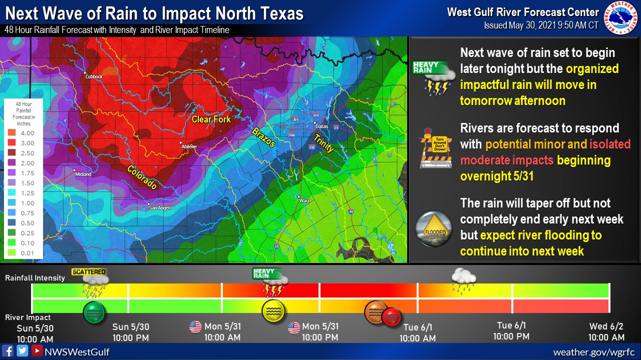
More rain on the way, it's always good when the Panhandle and/or West Texas can pick up some rain heading into Summer.
Re: Texas Spring 2021
Posted: Sun May 30, 2021 7:19 pm
by JDawg512
Had a few rounds of heavy rain this evening here in S. Austin. Over an inch so far last I saw the rain guage.
Re: Texas Spring 2021
Posted: Mon May 31, 2021 9:47 am
by rwfromkansas
Rain much more widespread than expected in DFW. Wonder if that will diminish the widespread storms tonight.
Over .50 and still largely training.
Re: Texas Spring 2021
Posted: Mon May 31, 2021 10:07 am
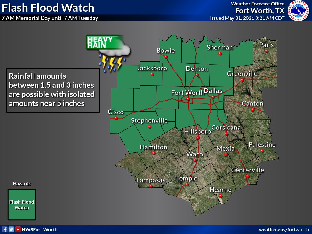
by bubba hotep
Flash Flood Watch up for DFW
and MOD Risk of Excessive Rainfall
Re: Texas Spring 2021
Posted: Mon May 31, 2021 10:14 am
by bubba hotep
rwfromkansas wrote:Rain much more widespread than expected in DFW. Wonder if that will diminish the widespread storms tonight.
Over .50 and still largely training.
It looks like this current band will spend the next few hours dying over DFW and it doesn't have a big stable cold pool behind in like some nocturnal storm complex's. In fact, CAPE is already increasing out West of DFW and strong southerly flow will keep pumping in the moisture today with storms firing again later as the cold front starts to move in.