Re: Texas Spring 2021
Posted: Mon May 31, 2021 10:52 am
Over an inch and still going. It will be a problem if areas get 2 plus tonight.
Welcome to Storm2k! Your Year Round Weather Community since 2002!
http://www.storm2k.org/phpbb2/
bubba hotep wrote:IIRC, that deep S. Texas MCS wasn't well forecasted? It probably knocked out the last of the drought down there.
https://i.ibb.co/x3YXhLW/Drought.png
Then the pattern looks to stay wet during the 1st half of June. At some point we might have to start considering that a below normal temp and above normal precipitation summer might be in the cards for Texas.
https://i.ibb.co/vVMVG21/Wet-Outlook.png
captainbarbossa19 wrote:bubba hotep wrote:IIRC, that deep S. Texas MCS wasn't well forecasted? It probably knocked out the last of the drought down there.
https://i.ibb.co/x3YXhLW/Drought.png
Then the pattern looks to stay wet during the 1st half of June. At some point we might have to start considering that a below normal temp and above normal precipitation summer might be in the cards for Texas.
https://i.ibb.co/vVMVG21/Wet-Outlook.png
I think the time for considering is about over now for the majority of June. The question is how long will this pattern continue this summer? June can often be quite wet. When June is wet, usually July features at least average temperatures and precipitation. Another thing to consider is even if the temperatures are below normal, heat index values will be above normal due to higher humidity. I would still rather have higher heat index values than drought.
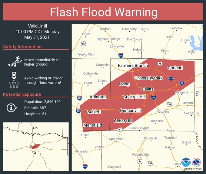
I don't think it will be a swing and miss.bubba hotep wrote:It looks like this might be another swing and miss Flash Flood watch for DFW (which is a good string of luck). Things look to be trending towards a MCS forming and then surging SE and missing DFW this afternoon.
starsfan65 wrote:I don't think it will be a swing and miss.bubba hotep wrote:It looks like this might be another swing and miss Flash Flood watch for DFW (which is a good string of luck). Things look to be trending towards a MCS forming and then surging SE and missing DFW this afternoon.

Texas Snowman wrote:Hey everyone, just a reminder that meteorological summer starts tomorrow. Hopefully this summer will be cooler and wetter than normal!
After tonight, we’ll move over to the Texas Summer 2021 thread at http://www.storm2k.org/phpbb2/viewtopic.php?f=24&t=121841.
See you in the Texas Summer 2021 thread - next up is fall and then winter!!!
bubba hotep wrote:starsfan65 wrote:I don't think it will be a swing and miss.bubba hotep wrote:It looks like this might be another swing and miss Flash Flood watch for DFW (which is a good string of luck). Things look to be trending towards a MCS forming and then surging SE and missing DFW this afternoon.
Latest HRRR run is pretty extreme with 4-5" totals across DFW, which is change from earlier runs that had the storms out west diving more SE and eventually forming a MCS. That line of showers lifting north through DFW is probably associated with the leading edge of some moisture/instability return and the axis along it is where I would watch for bigger totals.
https://i.ibb.co/ryhXYmC/CODNEXLAB-NEXRAD-FWS-N0-Q-20210531-2011-24-100.gif