Page 99 of 103

Re: Texas Spring 2022

Posted: Tue May 24, 2022 9:51 am
by Ntxw
Brent wrote:Still raining here :spam: hasn't been much of a break since yesterday around lunch. Tulsa was approaching 8 inches for the month already


You're setting yourself up for humid excessive heat warning days in the summer when Texas ridge flexes. 90 with heat indexes in Tulsa 110F with all that moisture :lol:. Glad for you guys, share some with us!

Re: Texas Spring 2022

Posted: Tue May 24, 2022 10:24 am
by HockeyTx82
Thoughts on the moring rain in NTX lessening our severe later on? Decent stuff moving in now it looks like.

Re: Texas Spring 2022

Posted: Tue May 24, 2022 10:36 am
by Ntxw
HockeyTx82 wrote:Thoughts on the moring rain in NTX lessening our severe later on? Decent stuff moving in now it looks like.


SPC discussion on enhanced is for MCS/QLCS and bowing sections for wind threats. They do note possible short tornado spinups. Main threat is heavy rain, small hail, and wind.

Re: Texas Spring 2022

Posted: Tue May 24, 2022 11:45 am
by bubba hotep
Latest HRRR really unloads on NTX.

Image

Re: Texas Spring 2022

Posted: Tue May 24, 2022 12:01 pm
by gpsnowman
On and off light rain here. It's something and it is during the daytime.

Re: Texas Spring 2022

Posted: Tue May 24, 2022 12:04 pm
by Brent
Ntxw wrote:
Brent wrote:Still raining here :spam: hasn't been much of a break since yesterday around lunch. Tulsa was approaching 8 inches for the month already


You're setting yourself up for humid excessive heat warning days in the summer when Texas ridge flexes. 90 with heat indexes in Tulsa 110F with all that moisture :lol:. Glad for you guys, share some with us!


Yeah I'm definitely dreading the humidity after this

Here comes another round. Y'all can have some now :lol: I'm about over it

Re: Texas Spring 2022

Posted: Tue May 24, 2022 12:06 pm
by WeatherNewbie
Looks like the current shield is going to miss most of the Metroplex.

Re: Texas Spring 2022

Posted: Tue May 24, 2022 12:41 pm
by Ntxw
WeatherNewbie wrote:Looks like the current shield is going to miss most of the Metroplex.


Minor blip, tonight for sure. Surely can't be less than 1" :lol:. Frustrating though watching it look decent earlier out west.

Re: Texas Spring 2022

Posted: Tue May 24, 2022 12:47 pm
by EnnisTx
Pouring on me in Arlington. :D

Re: Texas Spring 2022

Posted: Tue May 24, 2022 12:53 pm
by cstrunk
Why do I feel like the MCS moving north from SE TX/SW LA is going to evaporate but then ruin any instability for any later storms and I end up with less than an inch? :cry:

*Edit - I know why... because the HRRR is showing that too.

Re: Texas Spring 2022

Posted: Tue May 24, 2022 1:37 pm
by bubba hotep
WeatherNewbie wrote:Looks like the current shield is going to miss most of the Metroplex.


The outflow boundary associated with that is washing out and we are starting to see recovery of the air mass out west of DFW. It looks like DFW should retain it's CAPE and see recovery in areas that were impacted by this complex of storms, thus keeping heavy rain and storms on the table for later. We should see storms increase across West Texas as forcing moves in and then storms should overtake most of NTX later this afternoon and evening.

Re: Texas Spring 2022

Posted: Tue May 24, 2022 1:45 pm
by bubba hotep
Image

Re: Texas Spring 2022

Posted: Tue May 24, 2022 2:48 pm
by bubba hotep
Image

Re: Texas Spring 2022

Posted: Tue May 24, 2022 2:49 pm
by EnnisTx


URGENT - IMMEDIATE BROADCAST REQUESTED
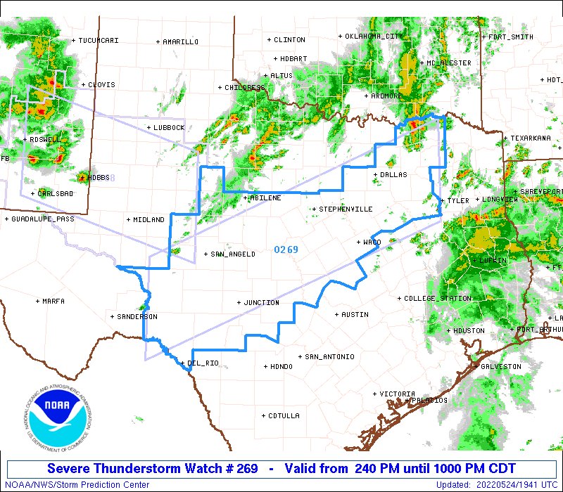
Severe Thunderstorm Watch Number 269
NWS Storm Prediction Center Norman OK
240 PM CDT Tue May 24 2022

The NWS Storm Prediction Center has issued a

* Severe Thunderstorm Watch for portions of
Central and Northeast Texas

* Effective this Tuesday afternoon and evening from 240 PM until
1000 PM CDT.

* Primary threats include...
Scattered large hail and isolated very large hail events to 2.5
inches in diameter likely
Scattered damaging wind gusts to 70 mph likely
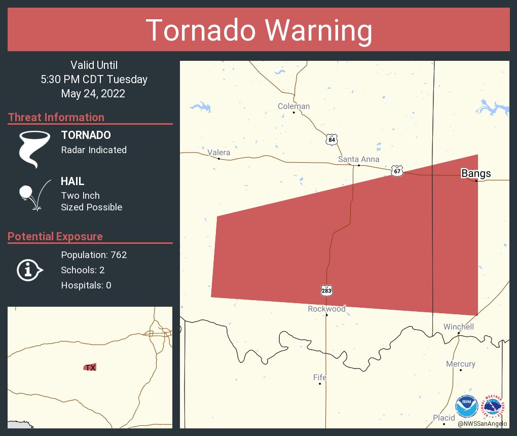
A tornado or two possible

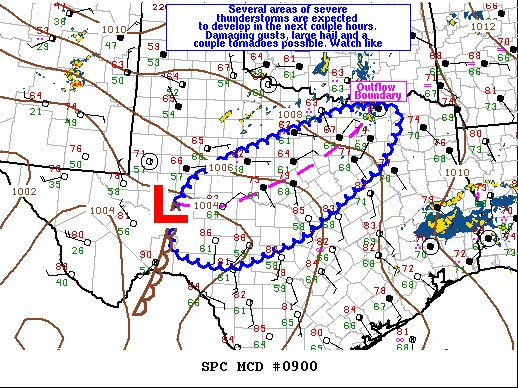
SUMMARY...Thunderstorms will intensify along a boundary from
northeast into central Texas. The stronger cells will pose a risk
of very large hail and damaging wind gusts through the afternoon and
evening. An isolated tornado cannot be ruled out.

The severe thunderstorm watch area is approximately along and 65
statute miles north and south of a line from 100 miles southwest of
San Angelo TX to 50 miles south of Paris TX. For a complete
depiction of the watch see the associated watch outline update
(WOUS64 KWNS WOU9).

PRECAUTIONARY/PREPAREDNESS ACTIONS...

REMEMBER...A Severe Thunderstorm Watch means conditions are
favorable for severe thunderstorms in and close to the watch area.
Persons in these areas should be on the lookout for threatening
weather conditions and listen for later statements and possible
warnings. Severe thunderstorms can and occasionally do produce
tornadoes.

&&

OTHER WATCH INFORMATION...CONTINUE...WW 268...

Re: Texas Spring 2022

Posted: Tue May 24, 2022 4:52 pm
by bubba hotep
Tornado warned cell SW of DFW

Image

Re: Texas Spring 2022

Posted: Tue May 24, 2022 5:20 pm
by jasons2k
0.35" here today so far.

Re: Texas Spring 2022

Posted: Tue May 24, 2022 5:35 pm
by rwfromkansas
.19.

And the rain coming in looks to be mostly for north metro. Bust again.

Re: Texas Spring 2022

Posted: Tue May 24, 2022 5:37 pm
by Edwards Limestone
My hometown of Midland is getting pounded. They need the rain so badly out there though.

 https://twitter.com/NWSMidland/status/1529229843249786880


 https://twitter.com/larrylee83/status/1529230371577114627


Re: Texas Spring 2022

Posted: Tue May 24, 2022 6:09 pm
by Ntxw
Fyi a similar set up the same week in 2015 with a big western low and Hudson PV dumped nearly 10" of rain on through memorial day at DFW (some crazy totals in central TX also.) Quite the same 5h but totally different background state.

Re: Texas Spring 2022

Posted: Tue May 24, 2022 6:32 pm
by cheezyWXguy
Ntxw wrote:Fyi a similar set up the same week in 2015 with a big western low and Hudson PV dumped nearly 10" of rain on through memorial day at DFW (some crazy totals in central TX also.) Quite the same 5h but totally different background state.

I remember that, the squall line marched its way toward the dfw area, and then rapidly slowed down right on my doorstep. I remember wondering when it would get here, and then wondering when it would stop, lol.